
Abstract
A key tenant of risk reduction models in archaeology the world over is that changes in resource availability drove mobility increases and created a need for an extension of stone tool use life. This manuscript directly addresses the question, is retouch intensity of tools related to distance from freshwater, by using extant localities of major Gorges, Rivers and water holes in the southern Kimberley region of northern Australia. Previous research has argued that retouched stone points during the mid to late-Holocene were part of a risk minimisation strategy, within broader technological organisation models. Modelling the distance from primary water sources, in arid to semi-arid regions of the southern Kimberley, reduction intensity of points is found to increase with distance from water sources consistently. This research provides an appropriate test of existing risk minimisation models and highlights global significance for similar studies where retouch tool reduction and forager mobility are linked to environmental change.
Introduction
Variation in stone tool morphology and resharpening rates can provide an insightful glimpse into ancient forager lifeways. Quantifying this variation in tool resharpening has led to theories dominating scientific interpretations of the Palaeolithic, including links with foraging risk minimisation (Bamforth and Bleed, 1997; Stiner and Kuhn, 2016; Torrence, 1989).Rarely are these models tested with proxy data, such as that extrapolated from stone tools and environmental records. That latter two data sources are at the forefront of explanations for a swathe of technological and cultural changes found in Archaeological records of mid to late-Holocene northern Australia. Here, the ubiquitous stone tool assemblages have revealed wide spread changes related to the production and proliferation of retouched tools, including bifacial points. Australian archaeologists have dedicated much research to understanding these Holocene changes, seeing various models proposed, tested and refuted, before a more recent focus on ecological modelling (see Hiscock, 2018). One proposition seeking to explain development and proliferation of bifacial point technology at this time, largely draws on shifts recorded in point retouching and tool provisioning, being linked to periods of Holocene aridity – forming a now wide spread model (e.g. Clarkson, 2007; Hiscock, 2011; Maloney, 2020b). Key to these studies, is the relationship between increasing mobility and point reduction; a challenging concept to quantify from archaeological records, yet one which holds promise for direct testing of this pervasive model for technological change in Australia. Using reduction indices and mid to late-Holocene stone points from the southern Kimberley of north Western Australia, this manuscript will test a key component of these point reduction and environmental risk models, the distance decay principle. These artefacts provide a case study of global relevance, as stone points are essentially convergent retouched flakes, with many archaeological parallels across the world.
Finding decaying exponential trends within reduction sequences of flaked stone tools can establish robust models of settlement and mobility (e.g. Andrefsky, 2008: 199; Goodale et al., 2008). Finding links between mobility, reduction trends and proxy records of aridity is more challenging, despite a wealth of study into Holocene climatic variability. Chiefly, the value of bifacial points in these examinations of the past is there exceptional preservation, often, as in this case study, in the complete absence of most other records of material culture. In Australia, Hiscock (1988: 108) demonstrated that at Lawn Hill, northern Queensland, people’s forays away from raw material sources, increased reduction intensity on stone points (Hiscock, 1994b, 2009, 2011). Raw material variability, being a general assessment of both the abundance and quality of stone resources (Andrefsky, 1994), is found to have no bearing on the level of point reduction in this study, leaving other factors to be explored.
Distance decay from freshwater has been otherwise neglected, despite its central importance to human lifeways. Studies of the Mound springs around Lake Eyre in Central Australia (Florek, 1993; Hughes and Hiscock, 2005) are some of very few which directly link stone tools to water availability and mobility change in Australia. Models for seasonal adjustments in ancient settlement systems have been employed in studies of the deserts of Western Australia (e.g. Veth, 2005), where seasonal rainfall was paramount to mobility adjustments and risk minimisation. Globally, researchers have had success using GIS applications in modelling settlement pattern relationships with distance from water; such as the Chalcolithic settlements of the Israeli Negev Desert, strongly linked to water sources (Fletcher and Winter, 2008: 2–3). These GIS-based studies identified a lack of insight into the structure of these settlements, or the meaning of the water-distance relationship for people’s lifeways. Stone tool variation across arid landscapes can shed light into these matters; and reveals global implications for forager mobility and adaption, via this Australian study.
Local environmental records within the study area are few, complex and varied; yet, consistently suggest increasing aridity beginning around the mid-Holocene which variably peaks between 2000 and 1000 years BP. Although dealt with in greater detail shortly, these proxy records and the abundant continuous records of Indigenous Australian culture, are assumed to reflect successful adaptations to climate change, and a continuous connection to freshwater.
For this reason, gorges have featured prominently in risk minimisation models of arid Australia (e.g. Hiscock, 1988; Maloney et al., 2019; Marwick, 2002; Veth, 2005). The assumption that these deep gorges amongst the arid study area, were indeed water sources during the mid to late-Holocene, is an assumption supported by arid zone lakes with aquatic records (e.g. Fitzsimmons et al., 2012), although none are available for the immediate site locations water resources. With these assumptions in mind, retouch intensity of stone points is found to increase with distance from water sources, providing further support for the risk reduction model and a case study of global significance for technological organisation theory testing.
This manuscript first outlines the risk minimisation model as applied to stone points of mid-to-late-Holocene northern Australia. With a model testing focus, this study recognises points as an adaptive technological response to increased foraging risks brought on by environmental change; which fuelled a need for higher mobility, and assumes that people adjusted their mobility to maintain reliable access to fresh water, amongst other factors. Predictions surrounding mobility increase during this time are examined by comparing point reduction intensity with distance from extant primary water sources, very likely to have been refuges of freshwater in the southern Kimberley during the mid to late-Holocene.
Technological organisation, foraging risk and Australia’s stone points
…an ingenious suggestion, but not a well demonstrated one (White, 2011: 69).
The ingenious suggestion criticised above is the risk minimisation model, which in part advocates that points were developed as a technological response to late-Holocene environmental change. For technological organisation theory, foraging risk is the severity and magnitude of failure in subsistence. Technological organisation is the structuring of technology around subsistence and settlement patterns (Bamforth and Bleed, 1997: 112–113; Torrence, 1989: 59). These subsistence patterns are organised around the variation in time and space of desired resources, and technology has an embedded relationship with those subsistence practices (Torrence, 1989: 58). Freshwater is a resource of the highest priority to human life; perhaps no more so, then for ancient foragers of the mid-to-late-Holocene arid phases in the southern Kimberley.
The development of Holocene point assemblages found across northern Australia are now widely argued to have been part of such a technological response to foraging risks (e.g. Clarkson, 2006, 2007; Hiscock, 1994a, 1994b, 2011; Maloney, 2012, 2019, 2020b; Maloney et al., 2017). These points are direct percussion retouched flakes with converging margins, produced on macro blade blank (Figure 1). They are found throughout the southern Kimberley after 5500 cal BP (Maloney et al., 2014). Use wear and experimental data suggest projectile use was rare, in favour of multipurpose functions and provisioning strategies (Brindley and Clarkson, 2015; Maloney, 2020b).
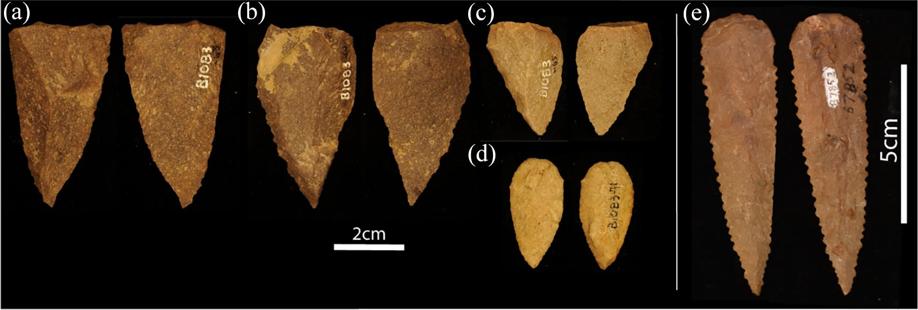
Stone points from the study area. A) Convergent flake or macro blade B) Unifacial point C) Unifacial point D) Bifacial point E) Pressure flaked ‘Kimberley Point’.
During periods of peak aridity in the late-Holocene throughout the Kimberley (McGowan et al., 2012: 4), point production, retouch intensity and tool recycling were correspondingly found to peak (Maloney, 2019, 2020b; Maloney et al., 2017). Similar trends have been identified in other areas of Australia using points and other stone tools (Clarkson, 2006, 2007; Hiscock, 1994a, 199b; Hiscock and Veth, 1991: 333–334). These temporal correlations are compelling enough to justify an examination for relationships between point reduction and distance from freshwater sources – this study being the first to do so from these contexts. The latter is reasonably established from extant major water sources and available proxy data.
A lingering critique of the risk reduction models applied to the variability of these stone tools, is indeed the lack of local environmental records, leading to problems in the direct testing of stone tools as risk-reducing technologies (White, 2011: 69). Australian risk models contrast periods of aridity gleaned from regional records of environmental change. The premise is that during periods of heightened aridity, there were probably roll-on effects to hunter-gatherer resources such as freshwater availability, to which people adapted and continued to thrive. Although this approach to mobility pattern modelling is global (Kuhn, 2012), the local record for the Australian environment requires summary.
A regional trend in environmental records of northern Australia
Australian researchers have used proxy records of El Nino-Southern Oscillation (ENSO) intensification, to model these likely changes or ‘roll-on’ affects to ecological resources; focusing on the impacts of increased aridity and periodicity of rainfall (Clarkson, 2006, 2007, 2008; Clarkson and Wallis, 2003; Hiscock, 1994a, 1994b, 2006; Veth, 1995, 2005; Veth et al., 2011). Intensification of ENSO moves the inter-tropical convergence zone to the north, which acts to reduce monsoonal rainfall, overall rainfall and the predictability of rainfall for northern Australia.
Generally, Australian paleoenvironmental records reveal a widely recognised pattern of intensified ENSO occurring around 5000 years BP, with locally varying peaks and troughs in this intensity between 6000 and 1000 years BP (Conroy et al., 2008; Denniston et al., 2013; Donders et al., 2007; Donders et al., 2008; Gagan et al., 2004; Moy et al., 2002; Rodbell et al., 1999; Schulmeister, 1999; Schulmeister and Lees, 1995). There is an equally widespread decline in ENSO intensity within the last 1000 years BP (Donders et al., 2007; Gagan et al., 2004; Lees et al., 1990), or slightly earlier (Denniston et al., 2013; McGowan et al., 2012).
Other proxy records, such as effective precipitation, likewise indicate increasing aridity after 5000 years BP (Schulmeister and Lees, 1995), causing patchy freshwater abundance. Hiscock (2018: 86) also adds that the introduction of the dingo, probably around 4000 years BP (Balme et al., 2018; Fillios et al., 2010) created resource reductions and altered fauna distribution at almost the same time as the ENSO driven changes.
Records of freshwater perennial lakes from the southern Kimberley provide support that the Gorge locations used in this study, are reasonable proxy water sources, for the model testing (Nanson et al., 1995; Wende et al., 1997). At Lake Mulan (Gregory) for example, there was no period detected within the past 50,000 years, where aridity was greater than during the Last Glacial Maximum (Fitzsimmons et al., 2012: 477), suggesting water availability during the mid to late-Holocene. The Black Springs Pollen records, suggested that during dryer phases of the past 5700 years, plant life supported by water, was always present (McGowan et al., 2012). From the latter records at Black Springs, the correlation between peak aridity, between 2600 and 1300 cal BP (Field et al., 2017; McGowan et al., 2012), show remarkable temporal correlation with point production, levels of retouch intensity and tool recycling at Mount Behn, between 2602 and 1747 cal BP (Maloney, 2019, 2020a; Maloney et al., 2017). While these proxy environmental records across the board region of north Western Australia (Figure 2), may seem spatially distant, they form the best and only local environmental proxy records, which can support water availiability and shifts in aridity during the mid to late-Holocene. This summary is given in support of the Gorge locations used in this study, as being probable to likely as freshwater stands during this time period.
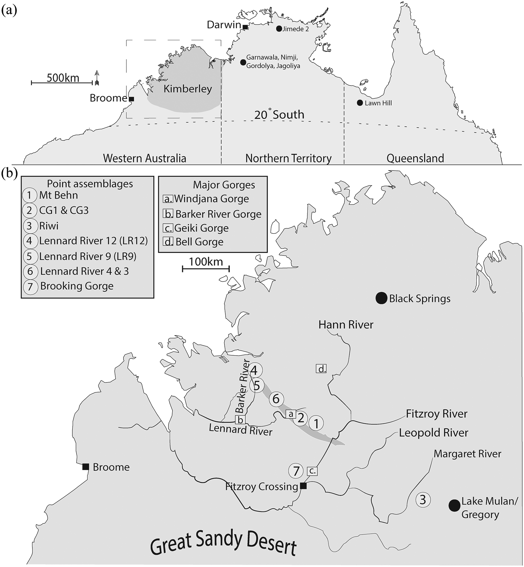
(a) Kimberley study area. (b) Sites, major rivers and gorges analysed in study.
The altered distribution and abundance of freshwater implied by these records are reasonably assumed to have immediate foraging risks regarding peoples day to day access to freshwater, but would have also promoted longer-term change in the distribution of edible plant species, fish and game animals. Hiscock (2006: 88) noted that the onset of a dominant ENSO pattern after 5000 cal BP would have not only made ecological resources less abundant, but less predictable. These roll-on effects of environmental change (Kuhn, 2011: 76) are thought to be the drivers of mid-to-late-Holocene foraging risk, responded to one technological way with adjustments in technology and mobility. Whether these adjustments were directly affected by distance to water is examined here, by comparing tool reduction from bifacial point assemblages with distance from likely contemporary water sources.
Stone tool reduction and risk minimisation in the Kimberley
While the Northern Territory and north Queensland sites (Figure 2) have a reasonably established risk reduction model argued to underlie variation in stone points (e.g. Clarkson, 2006, 2007; Hiscock, 1994b, 2011); this model is relatively new to the Kimberley record (Maloney, 2015). At Mount Behn (Figure 2), points peak in discard frequency, reduction intensity and recycling rates between 2602 and 1747 cal BP (Maloney et al., 2017). This proliferation period shows a notable temporal correlation with environmental proxy data, predicting extreme aridity (McGowan et al., 2012: 4; see also Whitau et al., 2018) as well as more regional records indicating more significant periodicity in rainfall. With the decrease in the predictability of subsistence resources and freshwater, Maloney (2015, 2019, 2020b) argues that southern Kimberley people probably expanded their foraging range during this time.
The increased mobility theoretically required a technology that could equip people for longer foraging trips and reduce the magnitude and severity of foraging risks. The extension of point use life is thought to offset part of this foraging risk, by increasing the likelihood that foragers would have an adaptable and ready tool kit to exploit resources when they were encountered (Hiscock, 2006: 81; Veth et al., 2011: 12). This technology reduced the frequency at which replacement raw material was needed, which would be advantageous when foraging in less familiar regions, where replacement raw material is not at hand, or access is unassured. Maintainability is manifest in the ability to continuously re-sharpen these tools, in predictable, and reliable ways. Standardisation of point technologies has been argued to provide an additional benefit, by facilitating regular blanks, consistent morphologies for hafting and predictable morphological transformations during maintenance (Clarkson, 2007: 150–160; Hiscock, 1994b: 278). The cost of this standardisation, particularly in producing regular blank morphologies, has been suggested as being recouped by the extension of point use life (Clarkson, 2008: 302). Archaeologists employ similar theoretical approaches to explaining retouched tool variation in most areas of the world (e.g. Bousman, 2005; Elston and Bratingham, 2002), yet few have quantified distance relationships relative to mobility (e.g. Andrefsky, 2008; Feblot-Augustins, 1993: 244).
Like most areas of the world, risk reduction models for tool variability in Australia are certainly not free of theoretical issues or complete objection (see White, 2011). In the Mitchell Plateau area of the northern coastal Kimberley, researchers have not found compelling evidence for a correlation between environmental change and stone points for example; instead, suggesting points offered a functional improvement to hunting gear (Veitch, 1999: 36), better correlated to occupation intensification (see Lourandos and Ross, 1994; Veitch, 1999: 363–365, 370).
Veth et al. (2000: 60) cautioned that potentially undermining ecological explanations of technology is the applicability of proxy records to local conditions. They suggested an acute need for investigation of local responses to local environmental change, leading to the imposing question for Australian archaeologists: …if the proximate cause of these Holocene technological changes is largely or partially the same. . .[ENSO]. . .what is the reason that different mechanisms of change occurred for different tool classes? (Veth, 2011: 120).
Despite feasibility and popularity, there remains scepticism of the consensus between point reduction and foraging risk in Australia; with far-reaching implications for archaeology more broadly. The major criticism is the lack of compelling local data, where the correlation between environmental and technological change is not enough. This research addresses this issue by comparing the distance to freshwater with retouched tool assemblages from the mid-to-late-Holocene in the southern Kimberley.
Social responses to foraging risk
Another criticism of ecological models explaining tool variability has been a perceived lack of social connections, with Bowlder (2011: 70) proclaiming a ‘risk minimisation confetti’ in Australian archaeology. Other researchers questioned how risk minimisation explanations could be applied to such spatially dispersed observations of technologies across diverse environments (Layton, 1997: 378; Mulvaney and Kamminga, 1999: 267; White, 2011: 68).
Firstly, it must be acknowledged that all forms of foraging and learning by humans are inherently social (Sterelny, 2012). Manufacturing certain tools across the Australian continent, or anywhere else in the world, were therefore ultimately products of social learning. Social interaction is implicit in all technological strategies. For example, in a discussion of highly mobile strategies, Kuhn (2012: 76) argues that there would be a higher probability of intergroup contact, which would incorporate social signalling. In the Australian Holocene context, Hiscock (2006: 86) suggested that increased mobility would have required ‘radical revision of inter-group social and political agreements’. These forms of social change have also been argued for the Kimberley study area (Hiscock and Maloney, 2017). If increased mobility during the mid-to-late-Holocene is associated with a distance decay relationship between water and point reduction; this would surely increase the frequency of intergroup connections and cultural exchange.
Samples and study area
The excavated and dated assemblages derive from Bunuba and Gooniyandi Country in the southern Kimberley (Figure 2). This region is arid to semi-arid, and home to several spectacular Gorges, including Windjana, Geikie, Barker River and Bell Gorge (Figure 2b). All of the sites can be said to have a strong cultural affiliation with the Fitzroy River; the principal waterway of the Kimberley basin. The Fitzroy River traverses around 730 km of the Kimberley, many Traditional lands and covers 94,000 km2 of the catchment (Creswell, 2009: 1). The Lennard River, which forms Windjana Gorge, covers some 15,000 km2 of the basin (Creswell, 2009: 1) and likely provided permanent water for the sites close to this Gorge. The Lennard joins the Barker River to the west and drains into King Sounds with the Fitzroy (Figure 2b).
All the sites and artefacts analysed in this study are within the Fitzroy River catchment, bounded to the North by the Leopold Ranges and the Canning Basin to the south, where the Great Sandy Desert begins. Within the past century (1930–2007), mean annual rainfall for this region is 577 mm, with strong seasonality (Creswell, 2009: 2). From these recent data, there is a notable, rainfall gradient, transitioning towards more arid areas of the Canning Basin to the south and the Gooniyandi site of Riwi (Balme et al., 2019).
Excavated and dated sites containing mid-to-late-Holocene units and points, within this study area, include Mount Behn (n = 137), Riwi (n = 9), Carpenters Gap 3 (n = 9), Carpenters Gap 1 (n = 2) and Brooking Gorge (n = 1) – see Figure 2b and Table 1 (Balme et al., 2019; Maloney et al., 2015, 2017, 2018a, 2018b; O’Connor et al., 2014).
Point assemblages and linear distance measurements.

Undated assemblages throughout this study area were also analysed. These sites include the Lennard River sites originally collected by Blundell (1975: 212–213, 218–221, 232–236), and reanalysed by Maloney (2015: 341–349; 2020b), which contain large numbers of points. While undated, these assemblages probably date to within the mid-to-late-Holocene, based on the association of stone points and absence of more recent tool forms (Maloney et al., 2014). All analysed sites are rock shelters or caves, which follow the Devonian limestone ranges (Playford et al., 2009: 234, 336).
Raw material availability, in the Andrefsky (1994) sense, throughout this study area is generally established as high abundance and low-quality north of the Fitzroy River; and low abundance and high quality to the south (Maloney, 2015: 42–44). Elsewhere, regional descriptions of raw material availability are provided by Akerman and Bindon (1995: 93), Akerman et al. (2002: 17) and Blundell (1975: 597–599) which support this distribution. There were no statistically significant differences in point reduction, using the invasiveness index, between the raw materials (Mann-Whitney: Z = −0.351, p = 0.725). With this established, shifts in point reduction are likely to relate to other factors faced by foraging groups.
Access to water must have been critical to the Bunuba and Gooniyandi people who lived in this Country during the mid to late-Holocene. The major gorges and rivers (Figure 3) provide a record of probable distance to reliable freshwater resources during this time. Gorges likely provided pools of freshwater between seasons, as they do today. For this reason, gorges have featured prominently in risk minimisation models of arid Australia (e.g. Hiscock, 1988; Maloney et al., 2019; Marwick, 2002; Veth, 2005).
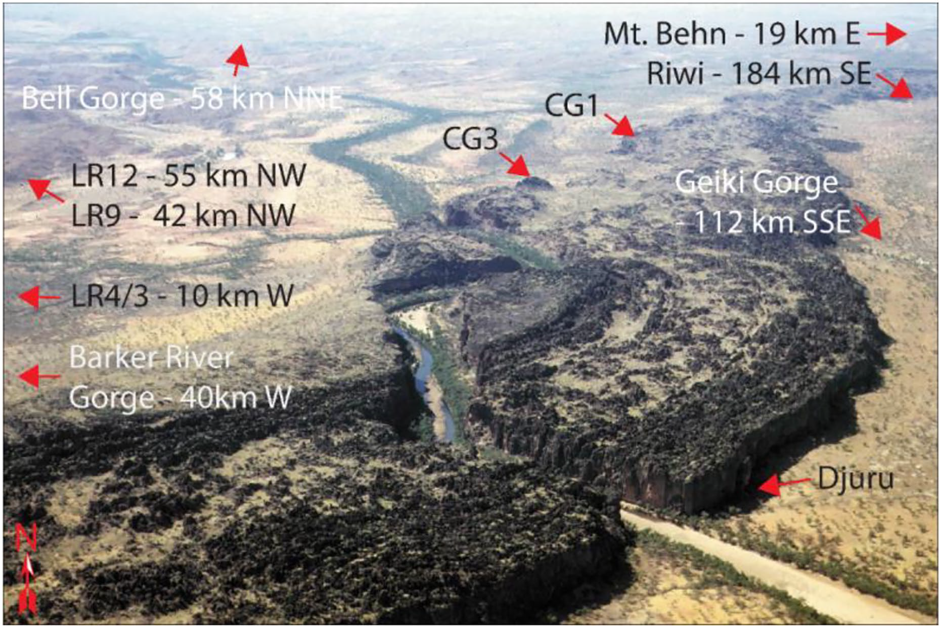
Proximity and bearing of sites to Windjana Gorge.
Carpenters Gap 1 (CG1) and Carpenters Gap 3 (CG3) are both located on the northern side of the range forming Windjana Gorge and contain deposits that span the Pleistocene to Holocene (Maloney et al., 2018a; O’Connor et al., 2014). Mt Behn, excavated in 2012, uncovered a vast lithic assemblage dating to the mid-to-late-Holocene (Maloney et al., 2017). Of these, an assemblage of direct percussion points was uncovered with varied and shifting retouch intensity. Shell beads were also uncovered throughout the site’s occupation record, and conform to a regional trend of increased shell bead trade/exchange towards the late-Holocene (Balme and O’Connor, 2016). Immediately adjacent to this site, a dry creek and gully trap a small amount of spring water during the dry season. While it is unknown how reliable this source was and is; the next closest likely permanent water source in Windjana Gorge. To the south-west, Riwi is located within the Laidlaw Ranges of Gooniyandi Country (Balme et al., 2019) and is further from major gorges and rivers, although water holes the author visited with Traditional Owners provide closer water sources.
The Lennard River sites provide a useful record of points to the west of Windjana Gorge following the Limestone Ranges. These sites also straddle distances between other major gorges and rivers (Figure 2b).
Hypotheses
If freshwater availability during the mid-to-late-Holocene did have a bearing on point technological design and curation, and precisely reduction intensity; it is hypothesised, that retouch intensity will increase with distance from primary freshwater resources in the study area. Furthermore, it is expected that point standardisation should maintain a consistent morphology with increasing distance from water sources. Point morphology should be generally maintained throughout increasing reduction and with increasing distance from water if standardisation was indeed emphasised. Thus, measures of retouch intensity should show increases with distance, and measures of morphological standardisation, should not significantly change with distance from water.
Methods
Distance from water calculations
Calculation of distance used Google Earth Pro (Google Earth Pro©). The coordinates used are the centre of each locality, and the linear distance calculated using Google Earth Pro, ‘path’ function (Google Earth Pro©). This linear distance is by no means intended to reflect the exact pathways walked by people and should be taken as a minimum distance between sites and water resources. More realistic tracks were only walked between some of the water sources and closer sites – for consistency; only linear measurements are used. This method, while approximate, is widely available.
Central localities are used for each coordinate. Windjana Gorge and Barker Gorge, for example, are taken from the central-most point of the extant water pool. The coordinates for each of the excavated rock shelters represent the central most position immediately to the entrance. All sites and water sources are illustrated in Figure 2b. Figure 3 shows the proximity of several sites around Windjana Gorge and its dry season pool of freshwater.
Comparison between sites reduction measures and distance to water also uses several mean values. For example, the mean distance from water is calculated as the average distance between all Gorges, closest water holes and linear distances to major rivers; for each site. Another value employed calculates the average distance from just the significant gorges. The closest water source is dependent on the site, although it includes water holes, springs, rivers and gorges.
Stone tool reduction measures
Distance to water is contrasted with stone tool retouch intensity measures such as the Index of Invasiveness (II) (Clarkson, 2002), percentage of perimeter retouched and Kuhn’s (1990) Average Geometric Index of Unifacial Reduction (AGIUR). All three indices have empirical support as viable measures of mass lost from retouched points (Maloney, 2020b) and are capable of quantifying the gradual spread of retouch. Not all indices were able to be applied to every specimen; AGIUR was not applicable to ventral retouch and was measured only on unifacial points, whereas the II could be applied to unifacially retouched specimens although it is less sensitive than when applied to bifacial specimens.
Morphological variables recorded with digital callipers include length, width and thickness. Length is recorded as maximum or box length, due to the tendency of retouch to obliterate the point blanks platform landmarks. Width is a perpendicular measure at the midpoint of length; where the thickness between ventral and dorsal surfaces is also taken (Figure 4). Shape indices calculated from these values include elongation and width to thickness ratio. All data used in this study is available in Supplemental File A.

Reduction indices employed in this study. (a) AGIUR on unifacial point. (b) Index of invasiveness on bifacial point. (c) Percentage of perimeter retouched. (d) Morphological measures of length, width and thickness.
Statistical tests
Appropriate statistical tests were performed using SPPSS v25. Following tests of normality, Univariate General Linear Models (GLM) and Linear Regression (LR) with analysis of variance (ANOVA), were selected as appropriate for the distance decay data and Mann-Whitney U (MU) tests for non-parametric data. The strength and significance (0.05) of these tests are taken as reflective of the effects of distance decay on the points being analysed.
Individually, some sites point numbers are too small for robust statistical comparison; Djuru and CG1, for example, each recovered 2 points respectively. CG1, CG3, Djuru and Mount Behn are combined as a single batch of Bunuba Country sites – with individual distance measures used for each site, within the batch. Similarly, batch tests are conducted for the overall sample, relative to the mean distances from water.
Results
Reduction intensity tests
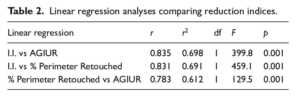
Firstly, the three measures of point retouch intensity are each in strong and positive agreement with one another (Table 2). The raw material availability of the study area is not drastically different (Maloney, 2015); which is supported by a lack of significant difference between retouch intensity and raw material types (MU: Z = −0.351, p = 0.725).
Linear regression analyses comparing reduction indices.
Collectively, the combined sample of points has a weak but highly significant correlation between reduction measures and the linear distance from each Gorge (Table 3). Examining these trends with distance from the closest water source, which includes water holes and rivers, reveals a similar pattern with the Index of Invasiveness (LR: r = 0.153, r2 = 0.023, df = 1, F = 7.846, p = 0.005). The greater the distance from these Gorges, the higher the invasiveness scores are, and the greater the marginal spread of retouch, across all points. The AGIUR is not widely applicable to the mostly bifacial points across the composite sample, although still supports distance decay with the unifacial points in the composite sample (r2 = 0.696, df = 1, F = 0.532, p = 0.001). These tests exhibit that distance from water across the study area is indeed correlated with increasing point reduction, as measured using these indices, despite the palimpsest of points within this initial study wide test. Individual site comparisons made below, show similar correlations, albeit with lower r values.
Linear regression comparing reduction indices with distance from gorges.

Comparing sites’ points with their respective closest gorge or water source is only viable for the Mount Behn assemblage, due to sample size (n = 137). As expected, the short distance from the immediately adjacent water hole (~200 m) has no bearing on Mount Behn point retouch intensity (MU: Z = −1.113, p = 0.266); while distance from the two closest major gorges, Windjana and Geikie (GLM: Ss = 7.106, F = 136.56, df = 1, p = 0.001), support distance decay. The more arid site of Riwi revealed significant relationships with distance from the major gorges (GLM: Ss = 0.148, F = 8.422, df = 1, p = 0.020), although the sample of complete points is notable smaller (n = 9).
Irrespective of the varied sample size at Mt Behn (n = 137) and Riwi (n = 9) for example, point reduction is found to increase with distance from major water sources – with both these sources being from dated mid to late-Holocene contexts. Performing the same tests on the Mount Behn points recovered only from units dated to before the last 1000 years (n = 126), when climate amelioration may have occurred, produces significant results for distance from the closest major gorges (p = 0.004) to the whole sample.
Lennard River 12 revealed significant correlations between retouch intensity and distance from the Barker Gorge, using both Index of Invasiveness for all points (GLM: Ss = 13.741, df = 1, F = 162.565, p = 0.001), and the AGIUR for unifacial points (GLM: Ss = 2.704, df = 1, F = 108.698, p = 0.001). The AGIUR is used on the Lennard River sites as there are substantially more unifacial points than the other sites.
Lennard River 9 also revealed significant correlations between retouch intensity and distance from the Barker River Gorge, using both Index of Invasiveness (GLM: Ss = 10.595, df = 1, F = 114.582, p = 0.001), and the AGIUR (GLM: Ss = 3.525, df = 1, F = 63.022, p = 0.001).
The other Lennard River sites, which contained smaller samples of points (LR4 = 15, LR3 = 16), are closer to Windjana Gorge then the Barker. Combining these two samples (n = 31) reveals distance from both gorges is nonetheless, significantly correlated with retouch intensity (Windjana GLM: rs = 1.020, df = 1, F = 6.071, p = 0.019 | Barker GLM: rs = 1.020, df = 1, F = 6.071, p = 0.003).
Combining all of the analysed points into a single batch (n = 1026), the distance from both Windjana Gorge (LR: r = 0.165, r2 = 0.027, df = 1, F = 9.313, p = 0.002) and Barker Gorge (LR: r = 0.132, r2 = 0.017, df = 1, F = 5.885, p = 0.016) are weakly, but significantly correlated with retouch intensity, gauged by the Index of Invasiveness. The same weak but highly significant trend is evident when focusing on the closest water sources (LR: r = 0.153, r2 = 0.023, df = 1, F = 7.969, p = 0.005). The mean distance from water, which includes local water holes as well as major rivers and gorges; reveals weak but highly significant trends between distance from water and retouch intensity (LR: r = 0.116, r2 = 0.014, df = 1, F = 4.562, p = 0.033 | GLM: ss = 3.303, df = 1, f = 44.960, p = 0.001).
Proximity to the Fitzroy River, the major waterway of the entire region, reveals significant relationships with the Index of Invasiveness (LR: r = 0.200, r2 = 0.040, df = 1, F = 13.761, p = 0.001) and percentage of perimeter retouched (LR: r = 0.149, r2 = 0.022, df = 1, F = 4.827, p = 0.029). Excluding Riwi from these analyses, provides a test of ever-increasing northwest distances from the Fitzroy River, following the limestone range some 75 km through Bunuba Country. This sample reveals the same weak but highly significant trends in retouch intensity, with ever-increasing distances from the Fitzroy River, and generally away from the more arid zone of the southern Kimberley (LR: r = 0.098, r2 = 0.010, df = 1, F = 3.075, p = 0.008). Overall, these tests suggest that distance from this major river influenced point reduction intensity, regardless of more local water sources; and together with the gorges, probably represents the best proxy for standing water during the mid-to-late-Holocene.
The statistical tests support the hypothesis that increasing distance from freshwater increases retouch intensity on all points. This trend is highly significant for all of the direct percussion stone points associated with the mid-to-late-Holocene across the southern Kimberley.
Morphological tests
Some morphological aspects of points are affected by mean distance from water. For example, length significantly decreases with mean distance from water (LR: r = 0.160, r2 = 0.026, df = 1, F = 17.961, p = 0.001), as well as major gorges (LR: r = 0.130, r2 = 0.017, df = 1, F = 11.862, p = 0.001). This is unsurprising, as continued resharpening generally makes for increasingly shorter points.
Relative thickness also changes with mean distance from water (LR: r = 0.170, r2 = 0.029, df = 1, F = 20.1, p = 0.001), and from gorges (LR: r = 0.153, r2 = 0.023, df = 1, F = 16.3, p = 0.001). The progressive thinning of bifacial points throughout reduction is expected with pressures to resharpen driving continual bifacial retouching. While reduction increases with mean distance from water, so too does point elongation values (LR: r = 0.205, r2 = 0.042, df = 1, F = 28.941, p = 0.001), point width on the other hand, does not (LR: r = 0.045, r2 = 0.002, df = 1, F = 1.345, p = 0.247). This suggests that with increasing distance from water, and increasing pressures to resharpen points, the relative width remains constant. The mass of points also did not reveal significant differences with mean distance from water (LR: r = 0.038, r2 = 0.001, df = 1, F = 1.496, p = 0.222), or from gorges (LR: r = 0.033, r2 = 0.001, df = 1, F = 1.123, p = 0.290).
These morphological trends are likely a result of maintaining the pointed morphology throughout reduction and conserving as much point mass and sharp working edge as possible. These trends and statistical tests provide support for the hypothesis that standardisation of points was being maintained throughout reduction, away from water sources during the mid-to-late-Holocene.
Discussion
Retouch intensity was found to be in weak but highly significant trends with distance from water sources across the southern Kimberley for all direct percussion stone points from the mid to late-Holocene. The distance from gorges and rivers appears to be associated with ever-higher levels of retouch intensity. These reduction sequences are also known to be concurrent with multipurpose use (Maloney, 2020b), and provide further support for high mobility settlement systems and enhanced social interactions amongst groups during the mid to late-Holocene (Hiscock, 2018: 87; Hiscock and Maloney, 2017). In this way, both ecological and social aspects of the point risk minimisation model are supported by distance decay from freshwater associated with point reduction.
While people continually resharpened their points, a general pointed morphology is maintained, where points became shorter and relatively thinner; although overall width and mass did not significantly alter. These trends provide reasonable support for point standardisation being maintained throughout reduction across the landscape. Standardisation provides predictable retouching patterns which help prolong tool use-life, but also, support reliable hafting arrangements regardless of the degree of resharpening (Clarkson, 2007: 155, 2008: 302; Hiscock, 1994b: 278). Standardisation for hafting could have influenced the consistency in point width. In an analysis of this same batch of points, Maloney (2020b) found use-wear evidence for multipurpose functions and only occasional projectile damage. Taking this use to have been concurrent with the continual reduction of points throughout the study area, distance from water sources appears to suit multifunctional and maintainability arguments for these tools. It seems, the further people were away from primary freshwater resources; the more likely point margins were renewed, rejuvenated and damaged points recycled (Maloney, 2020b). While point hafting and projectile use did occur occasionally (Maloney et al., 2015); the technological organisation properties of maintainability, standardisation and multifunctionality appear to be emphasised on all points from the study area. This phenomenon finds support from the consistent increase in point retouching with distance from likely water sources of the mid-to-late-Holocene.
It is also noteworthy that shell beads were uncovered at all of the excavated sites, most directly dated to the late-Holocene (Balme and O’Connor, 2016). These marine shell artefacts imply that distances of 500 km were no barrier at the time; whether these items made it to their final deposits as down the line exchange items or not. Mid-to-late-Holocene people of the southern Kimberley were highly mobile, maintained substantial economic and cultural connections to water and between widely distributed social groups.
An answer to the Veth et al. (2011: 120) question on the varied technological responses to late-Holocene environmental change; is that the effects of climate change on Holocene people’s subsistence and technological organisation was not unimodal. Areas in coastal Queensland, for example, may have had positive effects on local resource abundance (Turney and Hobbs, 2006). Research from both the Whitsunday Islands in Queensland by Genever et al. (2003: 141) and from Allen’s Cave in South Australia by Munt et al. (2018); provide case studies where no technological response to environmental change is manifest at this time.
Similar scenarios may have led to people in arid to semi-arid settlement systems across the Kimberley study area, adapting their technology and mobility to suit increased foraging risk beginning in the mid-Holocene. In contrast, coastal areas of the Kimberley, where no such response was detected (Veitch, 1999: 363–365, 370); the foraging risk could have been far less severe. The earlier development of points in the southern Kimberley, by at least 5500 cal BP (Maloney et al., 2014); and its later proliferation between 2746 and 3145 cal BP (Wk-1615) at Ngurini (Moore et al., 2020: 35) on the northwest coast; could reflect the earlier severity of foraging risks closer to the arid zone, which later spread north during peaks of aridity, point production and enhanced social interconnectedness.
It is plausible that environmental change in the mid-to-late-Holocene could have had both positive and negative effects on ecological resources, varying spatially as well as temporally. Diverse patterns of economic restructuring during the mid to late-Holocene, now appears to be a wide spread phenomenon, with multiple archaeological manifestations, outside of Northern Australia (e.g. Attenbrow, 2004; Smith, 1982).
Local proxy records remain essential for testable hypotheses of the ecological explanations underlying ancient technology, as demonstrated in this study. It is challenging to employ other proxy records from this study area to test risk minimisation theory for the mid-to-late-Holocene directly. Detailed faunal records from CG1 (Maloney et al., 2018a) document changes in prey selection at this time, indicative of multiple foraging environments and altered prey species, yet there are no comparable faunal records further away from Windjana Gorge. From macrobotanical and anthracological records at Mt Behn, Whitau et al. (2018: 30) argued that vegetation communities and people during the arid phases of the late-Holocene might not have been affected to the extent suggested by aridity from the regional climate signal. These data suggest people were exploiting multiple landscapes throughout the study area during arid phases of the late-Holocene at Mount Behn (Whitau et al., 2018: 30), which is indicative of high mobility and fits with the distance decay principles supported by this study.
Similar records from CG1 may suggest better preservation holds promise for comparative economic records (Dilkes-Hall et al., 2019). This latter research found a notable increase in economic plant use during the mid-to-late-Holocene, perhaps indicative of greater reliance on Windjana Gorge during the more arid phase (Dilkes-Hall et al., 2019: 43). Freshwater mussel shell is also a documented food source in all of the excavated sites of the study area, demonstrating further freshwater connections throughout the mid-to-late-Holocene.
Conclusion
Risk minimisation remains a compelling argument for the underlying causes of reduction and morphological variability amongst mid-to-late-Holocene point assemblages in Australia. Distance from water, calculated with the simple linear measure method in this study, provides one local proxy, with which to test principles of distance decay; which this study sought to examine. This method is simple and widely accessible for future archaeological studies and hence shows global significance for future studies of ancient mobility gleaned from stone tools. Point retouch intensity was found to increase with distance from probable freshwater sources of the mid-to-late-Holocene, while the pointed morphology is maintained. This trend is argued to reflect a highly standardised and extendible multipurpose technology, employed by mobile foragers responding to environmental change and its roll-on effects to subsistence risks, by expanded mobility.
Both economic and social factors were likely incorporated into the technological response, which led to this increased mobility. There is no evidence for a dichotomy between these two theoretical agents manifest in stone tool technology. Niche construction theory applied to similar arguments for backed artefacts in Australia (Hiscock, 2018); may provide a more prosperous understanding of late-Holocene stone point variability in future studies.
At the time of writing this manuscript, water access in the Kimberley is a contested issue, involving dams, irrigation, multinational corporations and Indigenous land and water rights (Department of the Premier and Cabinet, 2006; Moodie, 2019; Morgan, 2012; Vukovic, 2018). This research provides a timely case study of the longevity of cultural and economic connections to water across the southern Kimberley; and waters essential role in the adaptions, which lead to flourishing Indigenous cultures there. Using the methods demonstrated here, Archaeological science could potentially contribute to establishing the longevity of social and economical water connections with Indigenous people in other areas of contention around the world, such as Dakota, USA (Colwell, 2016).
Supplemental Material
sj-xlsx-1-hol-10.1177_09596836211033199 – Supplemental material for Thirsty work: Testing the risk reduction model of mid- to late-Holocene stone points with distance decay from freshwater in northern Australia
Supplemental material, sj-xlsx-1-hol-10.1177_09596836211033199 for Thirsty work: Testing the risk reduction model of mid- to late-Holocene stone points with distance decay from freshwater in northern Australia by Tim Ryan Maloney in The Holocene
Footnotes
Acknowledgements
My respects to the elders past and present on whose land this study was conducted. Thank you to Western Australian Museum staff Moya Smith and Alice Beale for access and assistance during analysis.
Funding
The author(s) disclosed receipt of the following financial support for the research, authorship, and/or publication of this article: The excavations featured in this study were funded by the Australian Research Council ‘Lifeways of the first Australians’ project (LP100200415). Thank you to Professors Sue O’Connor and Jane Balme. Thanks also to support from Professor Maxime Aubert’s Australian Research Council project, ‘The unknown “Ice Age” artists of Borneo’ (FT170100025).
Supplemental material
Supplemental material for this article is available online.
References
Supplementary Material
Please find the following supplemental material available below.
For Open Access articles published under a Creative Commons License, all supplemental material carries the same license as the article it is associated with.
For non-Open Access articles published, all supplemental material carries a non-exclusive license, and permission requests for re-use of supplemental material or any part of supplemental material shall be sent directly to the copyright owner as specified in the copyright notice associated with the article.