
Abstract
Volcanic eruptions are key drivers of climate variability, with complex environmental consequences at regional and local scales that are rarely documented in high-resolution sedimentary records. In this work we present the results of a 15 m long paleolake core (Pla de les Preses core, Vall d’en Bas, Girona, NE Spain) covering the Late Pleistocene-Holocene transition. Multiproxy analyses including chronostratigraphy, sedimentology, micropalaeontology and geochemistry are used to reconstruct the paleoenvironmental framework of the Late Pleistocene-Holocene transition and to detect the youngest Holocene volcanic eruptions in the Garrotxa Volcanic Field (GVF) and the Iberian Peninsula. The studied sedimentary record covers the last ca. 13.5 ka cal BP and was punctuated by several rapid climatic changes including the 9.3, 8.2 and 7.1 ka events, affecting the hydrological evolution of a barrier-lake formed due to the volcanic damming of the Fluvià river. Sedimentological and geochemical analyses unveil the environmental history of Vall d’en Bas valley; the formation of a lacustrine area within a fluvial environment around 13.5 ka cal BP and later a wetland phase between 9.3 and 8.2 ka cal BP. Abrupt sedimentary changes marking the onset and demise of the wetland phase were linked to hemispheric cooling and drying events (e.g. 9.3 and 8.2 ka cal BP), provoking a decline in the water table during these phases. In addition, 30 tephra layers are detected thorough the core, showing previously unknown intense volcanic activity from 13.5 to 8.3 ka cal BP in the GVF. In that sense, the Pla de les Preses sequence provides, for the first time, evidence for early Holocene volcanic activity in NE Iberia that should be taken into account in future tephra studies in the western Mediterranean realm.
Keywords
Introduction
Pyroclastic fall deposits are common in most volcanic areas, produced by many styles of volcanic eruptions. Field measurement and mapping of deposit thickness is an essential tool in the reconstruction of the past eruption histories of active volcanoes. The geological record of such events is severely biased towards larger eruptions, and the understanding of the preservation potential of thin, or distal, tephra deposits is far from complete (Pyle, 2016). In this work new Early Holocene volcanic activity is evidenced in the Quaternary La Garrotxa Volcanic Field (GVF) (northeastern Spain) through the detailed analysis of a paleolake core where many distal tephra layers represent the youngest known volcanic activity in the Iberian Peninsula.
The monogenetic Quaternary La Garrotxa Volcanic Field (GVF) forms part of the Catalan Volcanic Zone (Girona, NE Iberian Peninsula), one of the alkaline volcanic provinces of the European rift system (Martí et al., 1992). It is located in the Northeast of the Iberian Peninsula and covers an area of 600 km2, between the cities of Olot and Girona, 90 km NNE of Barcelona, in the pre-Pyrenees (Figure 1). The GVF contains more than 50 well preserved basaltic monogenetic cones that range in age from the Middle Pleistocene to the Early Holocene and include scoria cones, lava flows and maar-craters, which rest on Upper Palaeozoic granites and schists or on sedimentary Eocene and Quaternary substrates (Bolós, 2014; Bolós et al., 2014). Recent studies in this area have addressed the characterisation of the volcanic activity and petrology of the volcanic products (e.g. Cimarelli et al., 2010, 2013; Di Traglia, 2020; Gisbert et al., 2009; Martí et al., 2011; Pedrazzi et al., 2016, 2022) and the geological and structural controls of this magmatism and related volcanism (Bolós, 2014; Bolós et al., 2014, 2015).

Pla de les Preses core location in the Vall d’en Bas valley (Girona, NE Spain). The volcanic lava flows corresponding to the last 20 kyr eruptions are mapped in the digital elevation map. The PdP core detailed location, the Croscat volcano (in the background) and Olot city are visible.
The volcanic eruptions in the central GVF have been dated at ca. 700 ka (Araña et al., 1983), 247 ± 17 ka (Guérin and Valladas, 1980) and 13 ka cal BP (Puiguriguer et al., 2012). The last dated flows were likely associated with the most recent eruptions from the Croscat and the Puig Jordà volcanoes during the latest Pleistocene between 17 and 13.2 ka cal BP (Bolós et al., 2014; Puiguriguer et al., 2012). Nevertheless, the ages of the eruptions are not well resolved as they have high uncertainty and low reliability due to the difficulty of dating this type of young volcanic rocks.
The Vall d’en Bas valley is located in the SW area of the GVF (Figure 1). It consists of a tectonic graben (90.8 km2) involved in a complex fault system that is drained by the Fluvià river and its affluents. Successive lava flows in the GVF seem to have dammed the Fluvià river through the Quaternary and lead to the intermittent formation of a lacustrine basin in the deepest part of the Vall d’en Bas. In this work, we present the results of a multidisciplinary study of a 15 m long core obtained in the Pla de les Preses area at the Vall d’en Bas valley (Figure 1). The chronostratigraphic, sedimentological and high-resolution geochemical analysis of the core sediments, together with the characterisation of lacustrine biological proxies (aquatic pollen, non-pollen palynomorphs: NPPs, ostracods and charophyte gyrogonites) has allowed the identification and characterisation of a Late Glacial to Middle Holocene lacustrine and Late-Holocene fluvial infilling in the Vall d’en Bas valley and to perform its paleoenvironmental reconstruction. Moreover, several tephra layers related to previously unknown volcanic eruptions in the GVF between 14.0 and 8.3 ka cal BP are identified, which likely correspond to the youngest volcanic eruptions in the Iberian Peninsula, showing the potential of the volcanic barrier-lake deposits to identify and date volcanic eruptions in the GVF.
Material and methods
Pla de les Preses Core
A 15 m long core was obtained using a mechanical rotary drilling machine (TP-50/D) from the lowest part of the Vall d’en Bas valley (UTM 455189.0 X/4667356.0 Y/458.1 m a.s.l.), in the area known as Pla de les Preses (PdP) (Figure 1). The core is located in the central Garrotxa tectonic depression, one of the main depocenters in the GVF, and was selected based on previous data from nearby cores (Sidera and Les Palanques, Pérez-Obiol (1988); Cimarelli et al., 2013) and Capisa (unpublished technical report) pointing to the existence of a paleolake (Figure 1). The climate in the NE Iberian Peninsula is described as Mediterranean but with variations depending on altitude and distance from the sea. The topography of La Garrotxa represents an orographic barrier to humid and warm winds coming from the Mediterranean, which are forced to rise, causing high precipitation that is clearly differentiated in humid (spring and autumn) and dry (summer and winter) seasons (Linares et al., 2017). The annual precipitation in Vall d’en Bas (450–500 m a.s.l.) is 1014 mm and the mean annual temperature is 13°C. The average maximum temperature in summer is 21.6°C and the minimum is 5.8°C in winter. The main hydrographic features in the area are the Fluvià river and its tributaries, draining the major portion of the GVF (Candela et al., 2016; Linares et al., 2017; Figure 1).
Core chronology
The chronology for the recovered sedimentary sequence was obtained using 15 Accelerator Mass Spectrometry (AMS) 14C dates at the Beta Analytic Laboratory (Florida) and Poznan Radiocarbon Laboratory (Poland) (Table 1). An depth-age model, constrained by 15 AMS dates and the surface (Table 1), was built using the rBacon software (Blaauw and Christen, 2019).
Radiocarbon dated samples from Pla de les Preses core. The reported 16 control points were used to constrain the depth-age model.
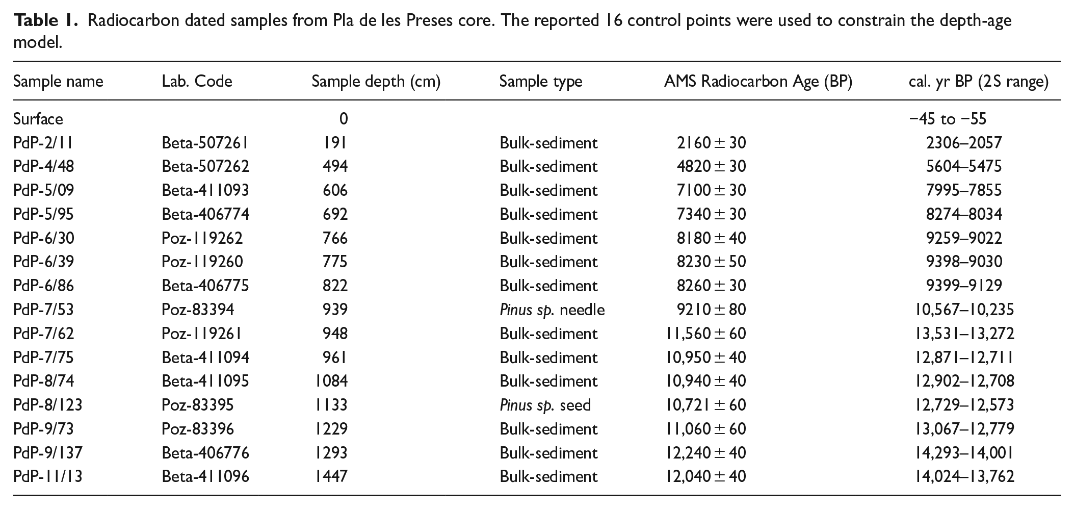
Most radiocarbon dates were measured on bulk organic sediment, but there are two dates that were measured on terrestrial plant remains (Pinus sp. needles and seeds). We assume that the latter dates provide more accurate sediment-deposition ages (e.g. Finsinger et al., 2019). Therefore, we assigned narrower Student’s t-distributions to plant-microfossil dates, and wider distributions to the bulk sediment dates.
The sedimentary sequence includes several volcanic tephra layers that were likely deposited in a very short period of time (days). These layers, representing abrupt events of sedimentation, were excised to calculate the age-depth model.
Stratigraphy and sedimentology
The stratigraphic study of the core was carried out considering the different sedimentary lithofacies. Sedimentary facies were defined by visual macroscopic description and microscopic observation of smear slides following LRC procedures (Schnurrenberger et al., 2003) and by mineralogical (DRX) (Suppl. Inf. Table I, available online), organic and geochemical (XRF-CS) compositions. Different stratigraphic units were defined along the core and their depositional processes and environments inferred based on their sedimentological characteristics (Reading, 1996; Walker and James, 1992).
XRF-Core scanner geochemistry
A high-resolution geochemical analysis (1 cm, and locally 2 mm, step-size) of the core was performed using an Avaatech XRF Core-Scanner at the Corelab Laboratory (University of Barcelona). The analysis was performed using a Rhodium source under two different working conditions: (1) with an X-ray current of 800 μA, at 10 s count time and 10 kV x-ray voltage for the measurement of Al, Si, P, S, Cl, Ar, K, Ca, Ti, V, Rh, Cr, Mn and Fe; (2) with an X-ray current of 2000 μA, at 25 s count time, 30 kV X-ray voltage and using a Pd filter, for the measurement of Ni, Cu, Zn, Ga, Ge, As, Br, Rb, Sr, Y, Zr, Nb and Pb. This method allowed a semi-quantitative analysis of the elemental chemical composition from Al to U, based on the proportion of counts per second (cps) for each element compared to the rest.
The most abundant and significant elements (Al, Si, Cl, K, Ca, Ti, V, Mn, Fe, Ni, Cu, Zn, Ga, Br, Rb, Sr and Pb) were selected for Principal Component Analysis (PCA), to reduce the number of variables and define the main stratigraphic units and processes involved in the formation of the core record according to their chemostratigraphy. The PCA was performed using SPSS 23.0 software with correlation mode, and factor scores for each sample and rotated (Varimax) solution were also calculated. Before the PCA analysis all unreliable measurements were removed to avoid biases in the statistical treatment of the data. XRF geochemical data was normalised using centred log-ratio transformation (Weltje and Tjallingii, 2008; Weltje et al., 2015) using CoDaPack software (Comas-Cufí and Thió-Henestrosa, 2011).
Aquatic pollen and non-pollen palynomorphs
Pollen samples were obtained each 3–5 cm in organic clayish and peaty facies and each 10 cm in inorganic terrigenous fine sediments. Samples were processed following standard methods (Girard and Renault-Miskovsky, 1969; Goeury and Beaulieu, 1979): treatment with HCl and NaOH, flotation in Thoulet heavy liquid, treatment in HF, and finally mounting in glycerine. 300–400 pollen grains of terrestrial taxa were counted using an Olympus Bx43 microscope fitted with x10 oculars and x40/60 objectives. Hygrophytic plants (Cyperaceae, Ranunculaceae Typha latifolia and Typha/Sparganium), fern spores and aquatic plants (Myriophyllum, Nuphar, Nymphaea, Potamogeton) were excluded from the pollen sum, which includes pollen of trees, shrubs and herbs. Pollen and spores were identified and counted with the help of a pollen atlas (Reille, 1992). The identification of non-pollen palynomorphs (NPPs) followed Van Geel (1978), van Geel et al. (2003), Revelles et al. (2016) and Revelles and van Geel (2016). Pollen and NPP percentages were calculated with reference to the pollen sum. As samples in the top 650 cm were poor in pollen content, we focus on the bottom part of the core (14.0–8.0 ka cal BP). In this work, we focused on those non-pollen palynomorphs and aquatic pollen taxa which mostly inform about the paleohydrological evolution of the Vall d’en Bas paleolake.
Some plant macrofossils were recovered from sediment samples and identified using a stereoscopic microscope (Leica M80 at 60x). Identifications were done based on the literature (Cappers et al., 2006; Mauquoy and van Geel, 2007) and a reference collection of seeds at the University of Monpellier.
Ostracods and charophyte gyrogonites
Sediment samples of around 20 g were retrieved for ostracod and charophyte analyses every 10 cm in the peaty and lacustrine facies (600–1470 cm depth). The samples were rinsed in water (using H2O2 to disaggregate clayish samples) and sieved at 250 μm. Finally, the samples were dried and all the ostracods and charophyte gyrogonites were picked up with a fine brush.
All ostracod remains (shells and disarticulated valves) were identified to species level whenever possible, following mainly Meisch (2000) and Fuhrmann (2012). Densities were estimated as the number of valves per gram of dry sediment.
The qualitative taxonomic characteristics used to identify the charophyte gyrogonites were the apical zone, the basal structures (presence or absence of a basal column, shape of the basal plate, etc.) as well as other features such as overall outline and number of spiral turns (or ridges) visible in lateral view (Soulié-Märsche, 1989; Soulié-Märsche and García, 2015). The observation and measurements were made with a stereomicroscope at 400x. Length was measured as the longest polar axis (LPA = vertical axis); width as the largest equatorial diameter (LED = horizontal axis at the largest diameter). The length/width ratio was also calculated and expressed as the isopolarity index (ISI = LPA/LED × 100).
Results
Pla de les Preses Core Chronology
The 15 radiocarbon dates obtained from bulk sediment and Pinus sp. remains (Table 1) constrain the core record between 14,024–2057 cal. yr BP (Table 1). Nevertheless, the depth-age model calculated through rBacon allowed to calculate the age of the entire core, ranging from present to ca.14 ka cal. BP, covering the Late Glacial to the Late-Holocene (Figure 2).
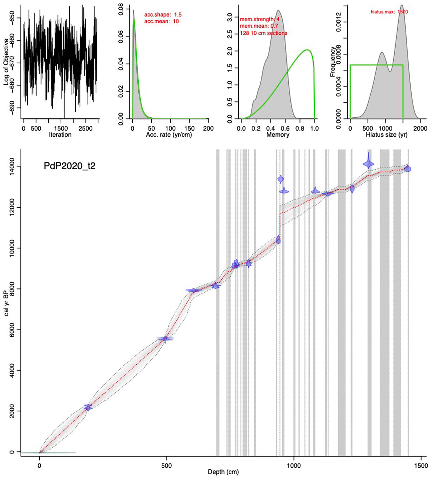
Depth-age model of PdP core with Student’s t error distributions. Note the excised abrupt sedimentation volcanic tephra layers (grey vertical bands), and a gap at 945 cm depth.
We set a gap at 945 cm depth, where a transition between two core drives coincides with an abrupt pollen-assemblage change that suggests the occurrence of a sediment gap at that depth; the occurrence of a hiatus in sedimentation is not supported by sedimentological or climatic indicators and seems to be caused by a sediment loss during coring operation. The maximum gap interval was set to 1500 years, between 11.7 and 10.5 ka cal BP.
Finally, the sedimentary sequence includes several volcanic tephra layers that were likely deposited in a very short period of time (days). These layers, representing abrupt events of sedimentation, were excised to stablish the depth-age model (vertical grey bands in Figure 2).
Stratigraphy and sedimentology
Four lithostratigraphic units (U1 to U4) were defined in the core including eight different sedimentary facies (Figure 3 and Table 2). In the basal part of the core, U1 ranges from the bottom up to 13 m depth. It includes orange to greyish carbonate mud with centimetre-scale fine sandy alternations (Facies G) that evolves to massive grey carbonate mud (Facies B) at 14.12 m and is present until 13.8 m depth. The grey carbonate mud includes a 5-cm-wide black peaty organic layer with vegetal remains (Facies C) at the bottom and gradually becomes sandier upwards (Figure 3). Between 13.8 and 13.05 m depth very coarse to gravelly siliciclastic sands (Facies D) with abundant organic mud clasts and bioclasts are present in two 20 and 33-cm-thick sand layers separated by a 20-cm-thick siliciclastic grey to black organic mud layer (Figure 3). The siliciclastic mud between both sand layers and another 2 mm to cm scale whitish to grey clay layers with sharp contacts at 14 and 13.5 m depth are significantly enriched in Zr and Al (also Mn and Fe) indicating a possible content of volcaniclastic sediment (Facies E) (Figures 3 and 4 and Suppl. Inf. Table I, available online).
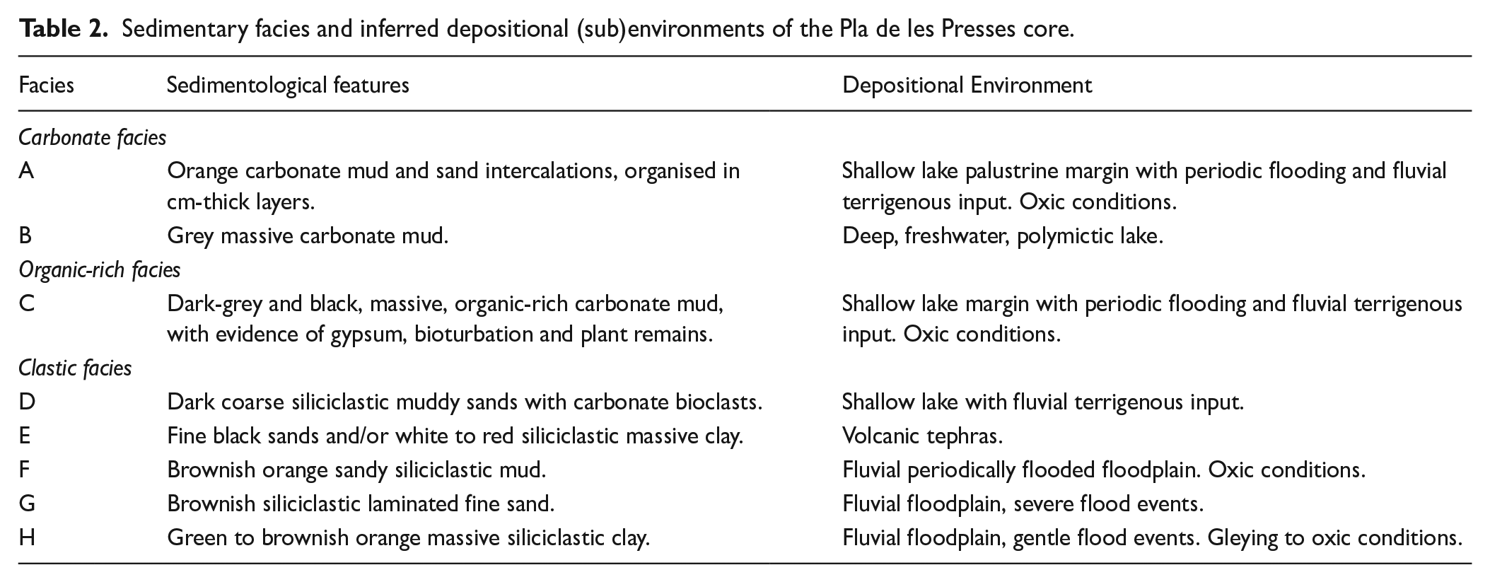
Sedimentary facies and inferred depositional (sub)environments of the Pla de les Presses core.
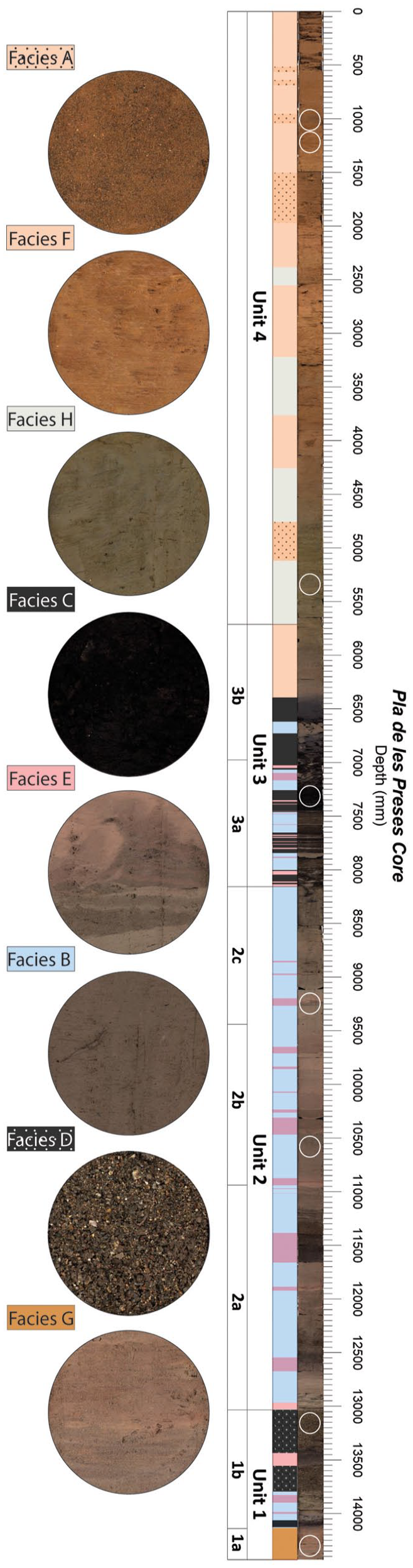
PdP core stratigraphy and main lithofacies (see Table 2 for facies description).

Main geochemical features of the PdP core indicated by most significant chemical element variation through depth. Most significative lithofacies changes are also indicated (Red bars: volcanic tephra layers; Grey bars: organic intervals; Orange bars: sandy layers; Greenish bars: greenish mud). Element abundance is expressed in counts per second (cps).
From 13.05 to 8.15 m depth, U2 is mainly composed of massive grey carbonate mud with some carbonate bioclast-rich intervals (Facies B) (Figure 3). It includes 15 intercalations of 5 mm to 25 cm-thick Zr-rich fine black sand and/or whitish to reddish grey laminated clay layers (Facies E) similar to the ones observed before in U1. Soft sediment deformation structures are visible in some of these layers, mainly when they include basal coarser sediment layers that form flame structures (Figure 3).
U3 (8.15–5.7 m depth) is mainly composed of an alternation of black organic carbonate to peaty mud (Facies C) that includes abundant centimetre- to decametre-scale bioclastic carbonate mud layers, and millimetre- to centimetre-scale whitish grey siliciclastic clay laminae (Facies E) (Figure 3). Fine laminations are sometimes disturbed due to soft sediment deformation features and possible root bioturbation traces. At the top of U3 the massive organic mud becomes less organic and more siliciclastic (Facies F), rapidly changing to massive greyish mud with fine sandstone intercalations.
Finally, from 5.7 m depth until the top, U4 is mainly composed of brownish orange siliciclastic sandy mud composed of an alternation of centimetre-scale fine sand and clay layers (Facies F) (Figure 3). Facies F presents intercalations of sandy intervals of brown fine sands with mud laminations (Facies A) in the upper 3 m of the core, intercalated in green to brownish orange massive siliciclastic mud intervals (Facies H) between 5 and 2.5 m depth (Figures 3 and 4). Some scattered millimetre-scale charcoal fragments are present.
In general, the arrangement of the sedimentary facies indicates a progressive transition from fine carbonate sediments (U1 & U2) to organic sediments (U3) that gradually change to siliciclastic terrigenous facies (U4) (Figures 3 and 4), all of them with episodic intercalations of Zr-rich mud and/or sand layers.
Geochemical analysis
The described lithostratigraphic units consist of geochemically well differentiated sediment types (Table 2 and Figure 4): mixed carbonate mud (Ca-rich) (U1, U2 and U3), sometimes with relatively high organic content (high Cu, Ni, Br presence) (U2), siliciclastic (Al, Si, K) fine-grained and sandy terrigenous sediments (U4) and Zr-rich terrigenous mud and sandy layers intercalated thorough U1, U2 and U3.
After PCA, the geochemical composition variation observed along the core sediments is summarised in four principal components (PC) which explain 83.4% of the total variance (Table 3). PC1 explains 38.4% of the variance and it is defined by Rb, Ti, Zn, Fe, V and Ga showing high positive loadings (>0.7) and Ca and Sr with a high negative factor loading (<−0.7) (Table 3). Factor scores show that chemical elements with negative loading in PC1 (Ca and Sr) are dominant in units 1, 2 and the first half of unit 3 (Table 3 and Figure 6). They show oscillations (reduced Ca content) in intervals where Zr-rich siliciclastic (red bands) or organic facies (grey bands) are present (Figure 4). The upper half of U3 and the entire U4 are characterised by the major presence of positive loading bearing PC1 elements: Rb, Ti, Zn, Fe, V and Ga (Table 3 and Figure 4).
Results from PCA analysis of the XRF-CS geochemical data from Pla de les Preses core. Communalities and factor load of the analysed 17 chemical elements are presented. Bold values indicate the maximum explained variance (factor loading) for each.
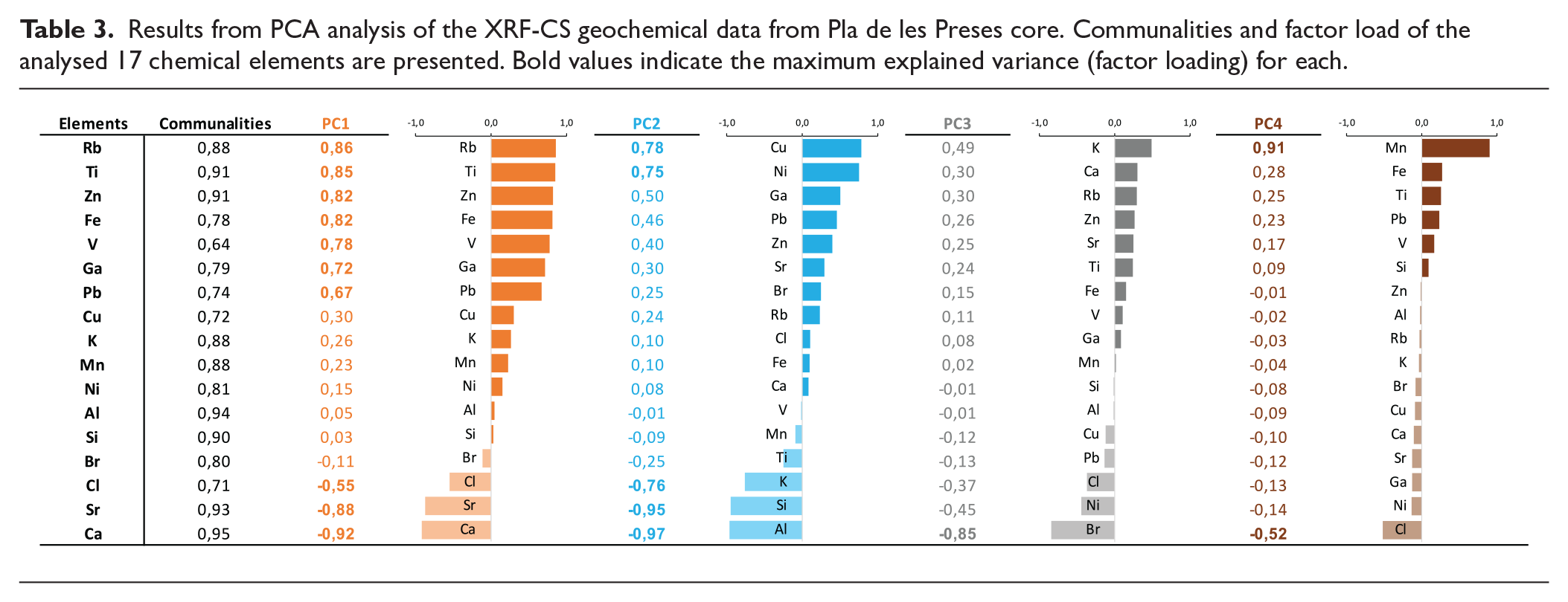

PC2 explains 26.5% of the variance. Cu and Ni show high positive loadings, and Al, Si and K show high negative loadings (Table 3). Factor scores (Table 3 and Figure 4) are positive in U1 and U3 pointing to a relevant presence of Cu and Ni. In U2 and U4 PC2 shows negative values, more negative in U4 than in U2, indicating a relatively higher Al, Si and K content in the former.
PC3 explains 10.2% of the variance. This PC includes only Br with a high negative loading (−0.85) (Table 3). The record of PC3 scores shows negative intervals, with higher Br content, mainly in the lower half of U3 and U4 (Figure 4).
PC4 explains 8.2% of the variance. Again, this PC includes only one element, Mn, with a high positive loading (0.91) (Table 3).
Aquatic pollen and non-pollen palynomorphs
In U1 (14.0–13.6 ka cal BP), high values of Cyperaceae are recorded, as well as the occurrence of Myriophyllum, Botryococcus and Spirogyra (Figure 5). Later, in the first half of U2 (13.6–12.5 ka cal BP), Myriophyllum, with regular occurrence of seeds, and Gloeotrichia predominate, in addition to peaks in Botryococcus and a continuous curve in Spirogyra. In that period, Cyperaceae declines. In the middle part of U2 (ca. 12.5 ka cal BP), a reduction in Myriophyllum and Gloeotrichia occurs, as well as the occurrence of low values of Cyperaceae and Spirogyra, high values of Botryococcus and Tetraedron, and the presence of Anabaena (Figure 5).

Main aquatic pollen, Ostracoda and charophyte gyrogonite taxa identified in PdP core sediments. Note the sedimentary gap between 10.5 and 11.7 ka cal BP.
At the end of U2 (10.5 ka cal BP), Botryococcus predominates and there is a continuous occurrence of Anabaena, a decline in Tetraedron, low values in Cyperaceae and Gloeotrichia and sporadic occurrence of Myriophyllum, Nuphar and Nymphaea. Later, during the U2-U3 transition (10.1–9.15 ka cal BP), there is a continuous presence of Botryococcus, showing some peaks, the sporadic occurrence of Tetraedron and Spirogyra, and low values of Gloeotrichia. The sporadic occurrence of Nuphar and Nymphaea around 10–9.7 ka cal BP becomes continuous with high values of Nuphar at 9.6–9.4 ka cal BP and of Nymphaea at 9.5–9.2 ka cal BP. In the case of Nymphaea, apart from pollen, seeds and suberised cells have also been documented in this period.
Finally, in U3, there is a clear change in the aquatic pollen spectra, with the disappearance of Nuphar, Nymphaea, Gloeotrichia, Botryococcus and Tetraedron, and the expansion in Cyperaceae (pollen and roots), ferns (mainly monolete spores, also Polypodium and Pteridium) and Spirogyra (Figure 5).
Ostracoda and charophyte gyrogonites
Four main Ostracoda assemblages have been differentiated through the sedimentary sequence. The first and richer one is observed in the lower half of U2 between ca. 1300 and 1050 cm (ca. 13.5 and 12.5 ka cal BP). The dominant species include typical forms of lakes in central Europe, such as Neglecandona neglecta, Candona candida, Ilyocypris gibba, Cypria ophtalmica and Cypridopsis vidua, but there is also presence of Herpetocypris sp. and a tuberculated unidentified form of Ilyocypris close to I. gibba and I. monstrifica, which we adscribed to I. cf. gibba (Figure 5). These last species disappear in the upper part of U2, up to 915 cm (11.7 ka cal BP), remaining only the most dominant five species mentioned above, but with a marked reduction in the density of the phytophilous C. vidua and an increase in C. ophtalmica (Figure 5). The third assemblage, present between 905 and 775 cm (top of U3 and lower part of U2) (between 10.5 and 9.3 ka cal BP) is dominated by N. neglecta, with a remarkable absence of previously abundant C. candida and C. ophtalmica, while Darwinula stevensoni and Cyclocypris ovum appear at some levels in this section (Figure 5). After one millennium without ostracod remains, at the end of U3, ca. 675 cm depth (ca. 8.2 ka cal BP), a very different and poor ostracod assemblage appears, including only two Candoninae forms of the genera Pseudocandona and Mixtacandona, the last one being close to the subterranean species M. idrisi (Figure 5).
Concerning charophyte gyrogonites, four different charophyte species were found in PdP core sediments: Chara aspera, Chara hispida, Chara vulgaris and Nitellopsis obtusa. Three species, C. aspera, C. vulgaris and C. hispida, are present from U1 to the lower half of U3 (1200–759 cm depth), with a maximum abundance during the upper half of U2. Nitellopsis obtusa is less abundant and is present throughout U2 (from ca. 1200 to 850 cm) (Figure 5). It disappears at 850 cm when fructifications from the other charophyte species are still present up to ca. 750 cm. In general, the gyrogonites of four charophyte species are present in U2 and the lower half of U3, with an increase in the number of gyrogonites (particularly of C. vulgaris) around 900 cm, with a maximum in 850–860 cm, at the upper part of U2 (Figure 5).
Discussion
In this section we present and interpret the main characteristics and changes observed in the PdP core over distinct phases. The sedimentary sequence from PdP core reveals both local and regional signals mainly related to palaeoclimatological, geomorphological and volcanic dynamics of the GVF area. Analysed aquatic proxies, sedimentology and geochemistry mostly report local hydrological variations, which are often related both to the inferred geomorphological evolution of the PdP lake and major Holocene climatic trends and rapid climate changes.
Pla de les Preses paleolake formation and evolution
The integration of sedimentological and geochemical data together with paleoenvironmental inferences obtained from ostracod, charophyte gyrogonite, aquatic pollen and non-pollen palynomorph analyses enabled the reconstruction of the lake formation processes in Vall d’en Bas valley and its limnological evolution thorough the Holocene (Figure 6). Seven evolutionary phases could be differentiated.
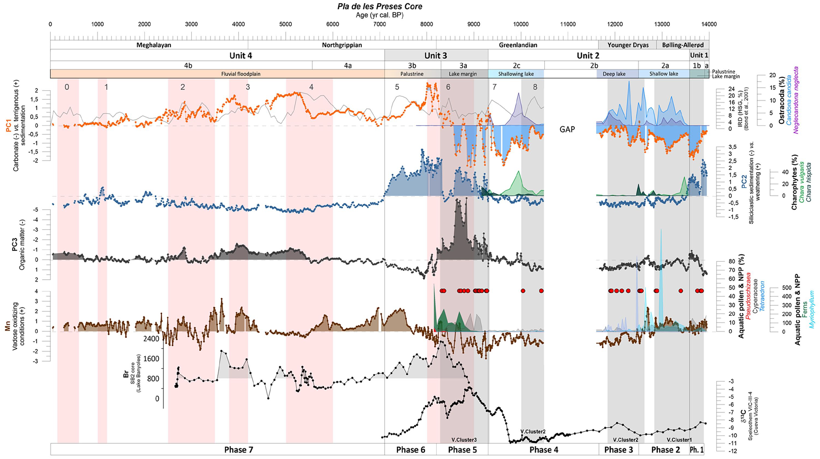
Main geochemical trends and micropaleontological content along PdP core. Extracted 4 principal components (PC) of the geochemical data and their inferred interpretation are shown together with the nearby Banyoles lake SB2 core Br content (Revelles et al., 2015) and Cueva de la Victoria (Murcia, SE Spain; Budsky et al., 2019) speleothem δ13C curve for reference. Red dots indicate the occurrence of tephra layers that are grouped in 3 volcanic clusters (grey shadow areas). Orange shadow intervals correspond to Holocene RCCs (after Mayewski et al., 2004), and the 0–8 IRD (Ice Rafted Debris) maxima to Bond Events (after Bond et al., 2001).
Phase 1: Late Glacial Fluvià river volcanic damming (Unit 1, 14–13.6 ka cal BP; 1445–1300 cm)
The core sequence starts with brownish mixed carbonate muds (Facies G, B) (see Ca curve in Figure 4 and PC1 in Figure 6) interpreted as subaerially exposed oxidised shallow lake margin sediments, indicating a possible shallowing trend during Subunit 1a. The shallowing trend ends with the subaerial exposure of previously deposited Subunit 1a carbonate mud (from >14 until 13.8 ka cal BP). The relatively high content of Cu and Ni (PC2 in Figure 6) and Mn in these sediments also point to frequent exposure and vegetation colonisation of the sediments in a palustrine environment, since Cu and Ni are usually bonded to hydrous Fe/Mn-oxides and humic substances in lacustrine sediments (e.g. Bendell-Young and Harvey, 1991; Schmoll and Förstner, 1979). The enrichment in Fe and Mn is probably related to vadose oxic conditions on sediments, which involve more favourable conditions for oxidised, less mobile forms of these elements to form (Chesworth et al., 2006; Jimenez-Espejo et al., 2020).
Afterwards, during Subunit 1b, a sequence of deepening upwards facies is observed, shallow vegetated lake margin organic sediments (Facies C) were deposited followed by carbonate-rich lacustrine grey muds (Facies B) denoting shallow water depth. Subunit 1b includes two decimetric intercalations of very coarse bioclastic sand (Facies D) that are interpreted as channel facies that reached the lake margin forming channel-mouth bars in small-scale delta (Wright, 1977). These sandy layers indicate high fluvial and sediment inflow events to the lake pointing to a relatively warm and humid interval at the end of the Bølling-Allerød (BA) as observed in other nearby western Mediterranean lacustrine records (González-Sampériz et al., 2017; Morellón et al., 2009; Pèrez-Obiol and Julià, 1994).
The inferred sedimentological changes and hydrological evolution are supported by the aquatic faunal and vegetal proxies. The high values of Cyperaceae pollen in facies B, which would have resisted better seasonal droughts in a floodplain or palustrine area, and the variable content of aquatic plants (Myriophyllum) and freshwater algae (Botryococcus) in Subunit 1b, shows the intercalation of low water level and even subaerial exposure phases during drier time periods (Figures 4 and 6). The lack of ostracod and charophyte remains during this phase may indicate a bad preservation environment for carbonate shells, either very shallow and temporarily dry and/or relatively acidic.
Although the shallowing trend and subaerial exposure inferred from Subunit 1a sediments could be attributed to a decrease of water level/table in the Vall d’en Bas basin due to humidity fluctuations during the Bølling–Allerød (BA) interestadial (GI-1) (e.g. Clark et al., 2012; Morellón et al., 2009), the subsequent deepening trend initiation at ca. 13.8 ka cal BP and evolution thorough the Early Holocene includes the Younger Dryas (YD) stadial (GS-1). The volcanic damming of the Fluvià river provoked the formation of a lake in the Vall d’en Bas valley during the latest BA interval and its deepening thorough the Early Holocene, even during the YD, as it is inferred in the PdP core. During the lake formation, in Units 1, 2 and 3, numerous tephra layers (Facies E) are found intercalated within lacustrine sediments (Figure 4). Their characteristics and implications are discussed in section 4.2.
Phase 2: Late Pleistocene shallow lake formation (Unit 2a, 13.6–12.5 ka cal BP; 1300–1095 cm)
During this phase, a progressive deepening of the dammed lake is observed (Unit 2). The sedimentary facies and aquatic proxies from Unit 2a indicate a shallow water lake margin formation. The main facies correspond to carbonate-rich mud (Facies B) with abundant interbedded dark ash volcaniclastic layers (Facies E) and occasionally centimetre-thick organic sediments (Facies C) with root bioturbation traces (Figures 4 and 6). The sedimentary facies from Unit 2a indicate the presence of a shallow lake littoral sedimentation (Facies B) with some lower water level periods evidenced by vegetation colonisation (Facies C). The higher carbonate (Ca) content and the relatively high presence of lithogenic elements indicates major authigenic carbonate production and sedimentation (see Ca and PC1 curves in Figures 4 and 6) together with a significant fine terrigenous siliciclastic input of fluvial origin. The relative absence of Cu and Ni content (PC2 in Figure 6) points to the absence of significant weathering processes, although the presence of Mn oxides indicate redox condition changes in intermittently flooded soils (e.g. Patrick and Jugsujinda, 1992).
The shallow lacustrine littoral environment inferred from sedimentology and geochemistry is supported by the aquatic organisms found in Unit 2a sediments. At the time when the lake is formed (ca. 13.5 ka cal BP), cyanobacteria (mainly Gloeotrichia) predominated, fixing nitrogen in a nutrient-poor environment (Van Geel et al., 1984) (Figures 5 and 6). High values of Myriophyllum and Cypridopsis vidua at 13.5–12.5 ka cal BP (Figures 5 and 6) point to the presence of relatively wide areas of shallow or littoral waters. The ostracod assemblage in this period (Figures 5 and 6) include species common in permanent, deep freshwater lakes, especially from Central and Northern Europe at present (Meisch, 2000), indicating cooler temperatures during the Late Glacial.
Concerning charophyte presence, Chara vulgaris gyrogonites prevail in this phase, especially at the bottom. Chara aspera and Nitellopsis obtusa are also present but they are less abundant (Figures 5 and 6). C. vulgaris and C. aspera are small and fast-growing pioneer species while N. obtusa is a dioecious species with a patchy native distribution throughout Europe and Asia. N. obtusa plants can grow tall (up to 120 cm) and are generally found in depths ranging from 2 to 14 m in oligotrophic to mesotrophic permanent lakes and slow-running freshwaters (Korsch et al., 2008; Rey-Boissezon and Auderset Joye, 2015), but it has been also found in shallower waters (0.5–1.5 m; Boissezon et al., 2018). It behaves as a perennial species that forms dense and large meadows in deep conditions, where it survives vegetatively by means of bulbils and overwintering of the above-ground parts, while rarely producing antheridia and, even more rarely, oogonia and therefore no gyrogonites (Stewart and Church, 1992). But in shallower systems, high sexual fertility has been described (Boissezon et al., 2018). Thus, the presence of N. obtusa gyrogonites in PdP samples suggests a relatively shallow habitat (around 1 m deep).
Unit 2a presents the richest ostracod paleoassemblage of the core and includes mostly species common in permanent, deep freshwater lakes, especially from Central and Northern Europe at present (Meisch, 2000), but also a peak of some species possibly indicating shallow littoral conditions, rich in vegetation, in agreement with the highest density of charophyte remains (Martín-Rubio et al., 2005). Therefore, we would expect a cold-water lake with a variety of habitats, promoting a diverse assemblage. In this sense, we can find species able to dwell in deep habitats such as N. neglecta or C. ophtalmica, and others more common in shallow ones, usually rich in submersed vegetation, including Ilyocypris spp., C. vidua or C. ovum (Meisch, 2000; Rieradevall and Roca, 1995; Figures 5 and 6).
The subsequent deepening trend initiation from Phase 1 continues during Phase 2 and includes the transition from BA (GI-1) to YD (GS-1) stadial, that is characterised by the onset of relatively cold and arid conditions in the northern Iberian Peninsula (e.g. Moreno et al., 2010; Rossi et al., 2018) and in nearby Mediterranean lakes (Morellón et al., 2009). This change to aridity is not observed in PdP core, on the contrary, a deepening trend is observed. As commented before, this contradictory fact is attributed to the water accumulation due to the volcanic damming of the Fluvià river and the onset of a lacustrine water mass in the Vall d’en Bas valley (Figure 1). Moreover, the sedimentation rates show maximum values during this phase related to the high accommodation space formation due to the progressive deepening of the lake and the high sediment inflow from nearby fluvial input points (e.g. littoral lake deltas). Therefore, volcanic and geomorphological changes affecting the drainage system of the Fluvià river and the subsequent lake formation mask the regional hydrological and paleoenvironmental variations related to the onset of the YD in the PdP core sedimentary record.
Phase 3: Younger Dryas lake deepening (Unit 2b, 12.5–11.7 ka cal BP; 1095–945 cm)
During this phase the stratigraphic Unit 2b was deposited. The sedimentary facies observed are like the ones from Unit 2a, being composed of massive mixed carbonate and siliciclastic mud with intercalated volcaniclastic ash layers (Figures 3, 4 and 6). The siliciclastic clay content reaches maximum values during this phase at ca.12 ka cal BP, probably denoting less authigenic carbonate formation due to reduced photosynthetic activity of the phytoplankton in colder and/or deeper conditions (Morellón et al., 2009; Reading, 1996; Figures 4 and 6). Continuous aggradation of relatively deep fine sedimentary facies indicates that the lake reached its maximum depth during this phase. Since maximum water level in dammed lakes is controlled by the height of the dam, the volcanic lava barrier, it is probable that the lake changed from close to open lake hydrological dynamics at the end of this phase.
The deepening trend of the lake is also evidenced by aquatic organisms. During 12.5–11.7 ka cal BP there is a succession from Gloeotrichia-Myriophyllum to Chlorophyta algae (Tetraedron, Botryococcus) and Cyperaceae and Spirogyra show low values, suggesting deeper water environment (Figures 4 and 6). In that context, the near disappearance of the charophyte remains during this phase might also indicate an increase in water depth which could have prevented the profusion of previous forms of Ostracoda and modified the life cycle of N. obtusa towards predominance of vegetative reproduction. Some ostracod species from the previous phases, particularly Ilyocypris cf. gibba forma tuberculata, C. ovum and C. vidua, either disappear or show a decline during this phase. This, together with the increase in C. ophtalmica and the reduction in charophyte remains indicate an increase in lake depth and the consequent proportional reduction of shallow habitats (Figures 5 and 6). Finally, the high abundance of C. candida points to cold water conditions. This species is present through all major glacial cycles during the Quaternary and is especially abundant in the European Late Glacial, and historically in arctic environments (Alm, 1915; Fuhrmann et al., 1997). Indeed, it is one of the European freshwater ostracods with lowest thermal optima (Horne and Mezquita, 2008).
This phase encompasses the Younger Dryas (YD or GS-I Stadial), a cool, and generally dry, abrupt event that very likely resulted from a prolonged weakening of the Atlantic Meridional Overturning Circulation (AMOC) (Bakke et al., 2009; McManus et al., 2004). This abrupt change was precisely dated and recorded in Iberian lake records (Gil-Romera et al., 2014; González-Sampériz et al., 2006; Leunda et al., 2017; Morellón et al., 2018) and speleothems from northern Iberia (Baldini et al., 2019; Bernal-Wormull et al., 2021, 2023; Moreno et al., 2010; Rossi et al., 2018) confirming its cool and dry character in southern Europe. The GS-I stadial was characterised by the onset of relatively cold and arid conditions in North Iberian Peninsula (e.g. Moreno et al., 2010; Rossi et al., 2018) and specially in nearby Mediterranean lakes (Morellón et al., 2009) that did not show a significative impact on vegetation in the milder NE Iberia (González-Sampériz et al., 2017; Pèrez-Obiol and Julià, 1994). This contradictory fact, the deepening of the Vall d’en Bas lake during the drier YD interval, is attributed to geomorphological changes produced by the intense volcanic activity in GVF between 15.7 and 13.2 ka cal BP (Di Traglia et al., 2009; Di Traglia, 2020; Puiguriguer et al., 2012). At that time, the Puig Jordà volcano eruption produced large lava flows towards the west, damming the Fluvià river 1 km downstream from the PdP core (Figure 1). The slightly lower authigenic carbonate production and the ostracod taxa identified suggest relatively cold waters during the first half of the YD in the Vall d’en Bas paleolake. But in contrast to other Iberian lake records, characterised by low water levels during the YD (Morellón et al., 2018), the Vall d’en Bas paleolake shows deeper conditions due to the continuous infilling of the dammed area.
Phase 4: Early Holocene lake shallowing and the 9.3 ka arid event (Unit 2c, 11.7–9.3 ka cal BP; 1095–815 cm)
The Early Holocene Unit 2c is composed of the same sedimentary facies present in previous Unit 2. Carbonate-rich mud, with few intercalated volcanic ash layers, shows the highest Ca (carbonate) content thorough the core (Ca and PC1 from Figures 4 and 6), indicating a maximum authigenic carbonate production during Phase 3. This fact could be related to high organic productivity and photosynthetic activity as it is also observed from a slight but progressive increase in organic matter content (PC3 in Figure 6) related to warmer water temperature as evidenced by the aquatic organisms from this phase.
Since 10.5 ka cal BP (but it probably started with the onset of the Holocene) a major change in the ostracod paleocommunities is observed (Figure 5). The cold indicator species C. candida disappears. This, together with the expansion of the eurytopic Neglecandona neglecta and the increase of Darwinula stevensoni and C. vidua, two species nowadays relatively abundant in the nearby karstic Lake Banyoles (Rieradevall and Roca, 1995) agree with an increase in temperature at the onset of the Holocene. This is confirmed by the increase in the number of gyrogonites (particularly of Chara vulgaris), indicating higher fertility in warmer waters. The presence of Lindavia radiosa (planktonic diatom) at 10 ka cal BP and continuous occurrence of Anabaena (cyanobacteria) at 10.3–10.2 ka cal BP points to deep water and eutrophic conditions, but there was a shift soon, since the occurrence of Nitellopsis obtusa gyrogonites at 10.2–10 ka cal BP (Figures 5 and 6) suggests a relatively shallow habitat (around 1 m deep) and oligotrophic to mesotrophic waters. The disappearance of N. obtusa gyrogonites and the general decrease in charophyte remains from 9.8 ka cal BP onwards might indicate more trophic conditions and shading of the water column by the expansion of other macrophytes (Nymphaea and Nuphar) and the occurrence of more turbidity events due to successive volcanic eruptions at 9.7–9.1 ka cal BP time interval (Figures 4–6).
The observed shallowing process during this Early Holocene phase culminated in a marked fall of the lake water level and the onset of vegetated littoral peaty sedimentation environment at 9.3 ka cal BP; it was the onset of Unit 3 (Figures 4 and 6). This event is also present in the nearby Lake Banyoles and also represents a rapid change from charophyte-rich shallow carbonate platform facies to littoral peaty wetland conditions (Revelles et al., 2015) (Figure 6). Similar drying events were previously attested in western Mediterranean lacustrine records, for example, in Siles Lake, in the south-eastern Iberian Peninsula (9.3 ka cal BP) (Carrión, 2002), in Fuentillejo Maar (9.2–8.6 ka cal BP) (central Iberian Peninsula; Vegas et al., 2010), in Basa de la Mora (9.3 and 8.8 ka cal BP) (Pyrenees; Pérez-Sanz et al., 2013), in Lake Cerin (9.0 ka cal BP) (Jura Mountains, France; Magny et al., 2011) and Lake Accesa (9.0 ka cal BP) (central Italy; Magny et al., 2007). This lowering in lake water level corresponds with one of the main Holocene rapid climate changes (Mayewski et al., 2004) that corresponds to a globally detected dry and cold event centred at 9.3 ka cal BP (Fletcher and Zielhofer, 2013; Haas et al., 1998; Rasmussen et al., 2006), expressed as an episode of reduced rainfall and decreasing fluvial activity in Mediterranean areas (Magny et al., 2002) and dry episodes in the western Mediterranean (Budsky et al., 2019; Fletcher et al., 2010; Fletcher and Zielhofer, 2013; Frigola et al., 2007). This situation agrees with the interpretations of northward shift of the westerly storm track (Budsky et al., 2019; Walczak et al., 2015), as pointed out by records of increased moisture from Scandinavia (Bakke et al., 2009) and reduced moisture from southern France (Genty et al., 2006; Wirth et al., 2013) and northern Iberia (Aranbarri et al., 2014; Railsback et al., 2011) at this time.
Since the Vall d’en Bas paleolake was already an open lake, the 9.3 ka dry event most probably resulted in a lowering of the lake level, due to a lower water table, that promoted the fluvial incision of the volcanic dam. A higher incision rate would lead to the lowering of the position of the fluvial outflow point and the subsequent lowering of the water level, and the onset of the irreversible emptying of the lake. The concurrence of an arid event and increased incision rate amplified the lake water level drop around the 9.3 ka event and made it ostensible in the PdP core record.
Phase 5: Lake shallowing and the 8.2 ka arid event (Unit 3a, 9.3–8.2 ka cal BP; 8150–6950 cm)
During Subunit 3a further shallowing of the lake is observed, shallow vegetated lake margin organic peaty sediments (Facies C) were deposited with fine intercalations of carbonate-rich lacustrine grey muds (Facies B) and abundant millimetre- to centimetre-thick whitish volcaniclastic ash layers (Facies E) (Figures 3, 4 and 6). The onset of a shallow lake littoral sedimentation coincides with some lower water level periods when vegetation colonisation occurred (Facies C). The higher Ca content and the relatively high presence of lithogenic elements indicate major authigenic carbonate production and sedimentation (see Ca and PC1 curves in Figures 4 and 6) together with a significant fine terrigenous siliciclastic input of fluvial origin. The intermittent relatively high content of Cu and Ni (Figures 4 and 6) points to the onset of subaerial weathering processes in intermittently flooded soils (e.g. Patrick and Jugsujinda, 1992). PC3, related to the high presence of Br, is associated to the organic character of the sediments in Unit 3a (Figures 4 and 6). Bromine is incorporated to organic matter during natural formation of organohalogen compounds that are especially well retained in peaty sediments (Biester et al., 2004, 2006).
The shallow lacustrine littoral environment inferred from sedimentology and geochemistry is again supported by the aquatic organisms found in Unit 3a sediments. In fact, the lack of ostracod remains during the 9.3–8.3 ka cal BP period may indicate the presence of a bad preservation environment for ostracod carbonate shells, either very shallow and temporarily dry and/or relatively acidic. From 9.3 ka cal BP onwards, a change in the aquatic pollen spectra occurs, Nuphar, Nymphaea, Gloeotrichia, Botryococcus and Tetraedron disappear and the expansion of Cyperaceae (pollen and roots), ferns (mainly monolete spores, also Polypodium and Pteridium) and Spirogyra point to shallower and drier conditions in the core area (Figures 5 and 6).
Thus, the shallowing process initiated during Phase 4 (since 9.3 ka cal BP) continued through Phase 5 forming a vegetated lake margin. Moreover, at the end of Phase 4, at ca. 8.2 kyr cal BP, the shallowing process led to the abrupt results in the abrupt disappearance of the lacustrine facies and the subaerial exposure of the core area. Again, the 8.2 ka cal BP event is interpreted as an arid interval that enhanced the lowering of the water table and the lake level and thus promoted the fluvial incision of the volcanic dam. The lowering of the fluvial outflow point and the subsequent lowering of the water level promoted the transition from shallow vegetated margin during Unit 3a to the subaerial palustrine environment of Unit 3b. It is noteworthy to mention the presence of abundant thin, millimetre-thick, volcaniclastic ash layers interspersed in organic sediments that indicate the occurrence of numerous volcanic eruptions from 9.3 to 8.3 ka cal BP that constitute the first evidence of Holocene volcanic activity in the GVF and the youngest volcanic activity recorded in the Iberian Peninsula.
As mentioned above, the climatic stability of the Holocene was punctuated by a series of sudden climate changes, particularly during the Early Holocene (e.g. Mayewski et al., 2004). Among these, the ‘8.2 ka event’ has been identified as the largest and most abrupt climatic event of the Holocene (Rohling and Pälike, 2005) and interpreted as the result of an outburst of glacial meltwater from the Laurentide lakes in North America (Lewis et al., 2012). The influx of cold water into the Atlantic Ocean led to a reduction of sea surface salinity and a decline of the Atlantic meridional overturning circulation (AMOC), provoking a reduction in sea surface temperatures (SST) across the North Atlantic (Mary et al., 2017). The cooling effects of this event have been documented in proxies from the Greenland ice cores and across Europe (Prasad et al., 2009; Rohling and Pälike, 2005; Seppä et al., 2007). Short and sharp periods of colder or drier conditions have also been recorded at ~8.2 ka throughout the northern (Alley and Agustsdottir, 2005; Morrill and Jacobsen, 2005) and southern hemispheres (Bustamante et al., 2016; Dixit et al., 2014).
In the northern Iberian Peninsula, the 8.2 ka event is widely recorded, and as suggested by our data, it had a hydrological impact on NE Iberia, in agreement with previous studies conducted on pollen (Moreno et al., 2011; Muñoz-Sobrino et al., 2005; Nuñez, 2018; Pérez-Sanz et al., 2013), carbonate tufa sediments (García-Martínez de Lagrán et al., 2016) and speleothems (Rossi et al., 2018; Smith et al., 2016) suggesting drier and cooler conditions in terrestrial ecosystems from ca. 8400 to 7700 yr cal BP. Even human settlements located in a particular harsh region of the Central Ebro basin moved northward towards more humid Pyrenean areas during this interval (García-Escárzaga et al., 2022; González-Sampériz et al., 2009).
Phase 6: Lake draining (Unit 3b, 8.2–7.1 ka cal BP; 6950–5700 cm)
Unit 3b comprises green to brownish orange sandy siliciclastic mud (Facies F) (Figures 3, 4 and 6) interpreted as oxidised palustrine to fluvial sediments that were subaerially exposed. The mud from this unit has a low carbonate content, and together with the relatively high content of Cu, Ni and Mn in these sediments (Figures 4 and 6), it points to incipient weathering due to frequent exposure and vegetation colonisation of these sediments in a palustrine environment (e.g. Bendell-Young and Harvey, 1991; Schmoll and Förstner, 1979). The gradual increase of Mn oxides at the top of Unit 3b indicates redox condition changes in intermittently flooded soils (e.g. Patrick and Jugsujinda, 1992) in agreement with the onset of a fluvial sedimentary environment. The sedimentation rate shows a marked maximum during this phase, probably related to the high flooding frequency and fluvial sediment deposition during this phase (Figure 4). Two dark organic sediment intervals (Facies C), representing the last vegetated lake margin episodes, are present in the basal part of Unit 3a. Noteworthy is also the absence of volcaniclastic sediments in the entire unit.
After 8.2 ka cal BP the return to fluvial dynamics in Unit 3b is evidenced by the presence of stygobiotic ostracods (Mixtacandona sp. and Pseudocandona sp.) living in water saturated sediment interstices in palustrine and/or floodplain areas below the water table (Mazzini et al., 2017). In that context, the Cyperaceae-fern succession also points to increasingly drier conditions, with a palustrine lake margin to fluvial floodplain transition, during this phase.
Thus, the shallowing process initiated during Phase 4 (9.3 ka cal BP) culminated in Phase 6 with the draining and disappearance of the lake. At the end of Phase 6, ca. 7.1 kyr, a rapid change from lacustrine/palustrine facies to subaerial fluvial sediments (floodplain facies) is observed. This rapid change is broadly coincident with the arid 7.1–7.4 kyr event detected in northern Spain (e.g. Pyrenean Basa de la Mora lake, Pérez-Sanz et al., 2013), in Minorca Sea (Frigola et al., 2007) and southern Spain (Jalut et al., 2000; Vegas et al., 2010) and also correlates with a phase of forest decline detected in the Western Mediterranean (Fletcher et al., 2010) in relation to a widespread climatic anomaly (Hou et al., 2019). Thus, the final draining of the Vall d’en Bas lake could be promoted by an arid interval that enhanced the lowering of the water table and the fluvial incision and the disappearance of the volcanic damming. Therefore, the PdP area became again a fluvial environment after 7 m of lacustrine sediment aggradation due to the Fluvià river valley volcanic damming at ca. 13,500 yr cal BP.
Phase 7: Fluvial aggradation (Unit 4, 7.1 ka cal BP–present; 6950–0 cm)
This phase is composed by an alternation of siliciclastic sediments with different textures, massive greenish mud (Facies H), brownish orange sandy muds (Facies F) and laminated fine sand (Facies G) (Figures 3 and 4). Geochemically they are enriched in typical lithogenic elements from clay minerals and other silicates as quartz and feldspars (Si, Al, K, Ti, Fe, Rb, Zr) (Figures 4 and 6). The geochemical (Al and Zr-rich and Ca-poor) and mineralogical composition of these sediments (Figures 4 and 6, Suppl. Inf. Table I, available online) is similar to terrigenous siliciclastic and volcanic sediments analysed in the previous lacustrine units, indicating the upstream erosion and resedimentation of older volcaniclastic and fluvio-lacustrine sediments due to fluvial incision. The relatively high Mn content in most of the unit indicates the presence of a fluctuating near surface water table that also explains the differential formation and preservation of Br and edaphic organic matter (PC3 in Figure 6) in the sediments (Takeda et al., 2018). All these features, together with the absence of aquatic organisms and very poor pollen preservation indicate the fluvial character of the sediments from this phase.
The sedimentation rate decreases gradually the last 6500 years probably due to progressively less intense and/or frequent flooding activity, but this fact is not fully supported by previous works on Holocene flooding patterns in the eastern Iberian rivers (e.g. Benito et al., 2015a, 2015b). Alternatively, it could be also related to the ongoing fluvial incision of the Fluvià river in PdP area due to the progressively lower water-flow and the upstream erosion of the knickpoint formed by the volcanic dam, diminishing the flooding frequency and intensity, and subsequently the sedimentary aggradation in the area. Some variations in facies and geochemical indicators are also shown throughout fluvial sediments of Unit 4 (Figures 3, 4 and 6); the variations in PC1 to PC4 through time could indicate environmental and climatic changes, apparently related to Bond events (Bond et al., 2001) but their timing and paleoenvironmental meaning must be cautiously considered since a better chronological control for Unit 4 would be desirable. Dry conditions across much of Iberia between ca. 8 and 5 kyr BP are suggested by many stalagmite records (Baldini et al., 2019; Moreno et al., 2017; Railsback et al., 2011), and a sharp decrease of precipitation in northern Iberia (Stoll et al., 2013). Other lake records from Spain (González-Sampériz et al., 2017; Jambrina-Enríquez et al., 2014; Moreno et al., 2011) and the pollen-based climate reconstruction from Mauri et al. (2015), as well as the lacustrine δ18O record from ostracod shells in Morocco (Zielhofer et al., 2019), support relatively drier conditions increasing in Iberia and north Africa.
In summary, our data shows how the volcanic activity and its geomorphological effect, the Fluvià river valley damming, together with a humid phase during the Early Holocene in the northeastern Iberian Peninsula (Benito et al., 2015a, 2015b; Frigola et al., 2007; Morellón et al., 2018) promoted the formation of a closed lake in the Vall d’en Bas until 9300 yr cal BP. Afterwards, geomorphological processes such as the opening of the lake and the subsequent fluvial incision of the volcanic dam, together with the occurrence of arid events that punctuated the shallowing trend of the lake, promoted the total draining of the lake by 7.1 ka cal BP. Those arid events identified in the PdP core at ca. 9.3, 8.2 and 7.1 ka yr BP coincide with the Early Holocene Rapid Climate Changes (RCC) that promoted the co-occurrence of high-latitude cooling and low-latitude aridity (Mayewski et al., 2004). In the Northern Hemisphere, RCC intervals correspond to the so-called Bond events related to North Atlantic ice-rafting events (Bond et al., 1997, 2001) that changed the intensity and distribution of atmospheric circulation (e.g. westerlies) over the North Atlantic (Hu et al., 2022; Meeker and Mayewski, 2002) that seem to have controlled rapid humidity and ocean circulation pattern changes in western Mediterranean areas during this RCCs (Cisneros et al., 2019; Frigola et al., 2007; Figure 6).
Early Holocene volcanism in GVF: The youngest volcanic eruptions in the Iberian Peninsula
As in the GVF case, basaltic monogenetic volcanism is characterised by the formation of tectonically controlled grouped volcanoes (volcanic fields) that erupt relatively small amounts of mafic magma in short-lived eruptions typically lasting from a few days to a few months. Eruptions of mostly fine-grained ash usually trigger abrupt and considerable erosion, generating pyroclastic flows and lahars, and causing downstream aggradation (e.g. Bolós et al., 2021; De Rita et al., 1997; Hayes et al., 2002; Manville et al., 2009).
Chronologically, the volcanic eruptions in the central GVF have been clustered in four main periods that occurred between 700 ka (Araña et al., 1983) and 13.27–13.04 ka cal BP (Puiguriguer et al., 2012). Detailed stratigraphic studies of this area are reported in Cimarelli et al. (2013) and Bolós et al. (2014). The last dated eruptions were likely associated with the most recent eruptions from the Croscat (15.7–13.2 ka cal BP, Puiguriguer et al., 2012) and the Puig Jordà volcanoes (17 ka BP, Bolós et al., 2014). Nevertheless, the ages of the eruptions are not well resolved as they have high uncertainty and low reliability due to the difficulty of directly dating these young volcanic rocks.
In this context, the sedimentary record from PdP core offers the opportunity to study the volcanic activity in the GVF for the last 14 kyr, and for the first time to extent its activity throughout the Early Holocene, until 8.3 ka cal BP. The sedimentological and geochemical data from the PdP core make it possible to detect numerous tephra layers, mainly composed of millimetre-thick altered ash layers and dark centimetre-thick fine lapilli scoria layers (Figure 7 and Table 4).

Examples of different type tephra layers present in PdP core.
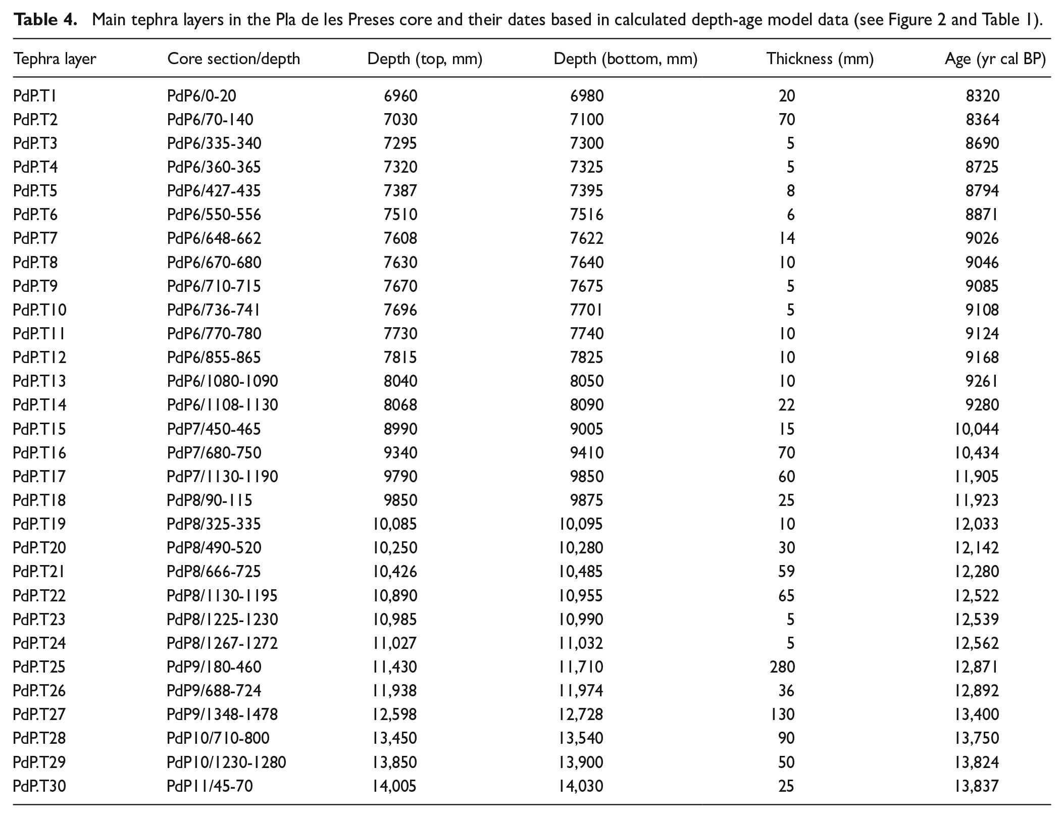
The vitreous composition and the altered character of most tuffaceous sediments make it difficult to obtain their original mineralogical composition (Figure 4 and Suppl. Inf. Table I, available online), but the geochemical (Figure 8) and sedimentary features clearly point to their allochthonous composition and origin (Figure 4 and Suppl. Inf. Table I, available online). In general, fine ash layers have whitish colours, whereas coarser fine lapilli (or very coarse ash) layers are black. They have more siliceous composition (clay minerals, quartz and feldspar presence) than autochthonous lacustrine carbonate sediments and are characterised by a red staining reflecting a high Fe content derived from volcanic mineral alteration and iron oxide (hematite) formation (Longman et al., 2023) (Figures 4 and 8 and Suppl. Inf. Table I, available online). Tephra layers are typically characterised by high Zr and low Ca concentrations (Figures 4 and 8), and hence produce higher value intervals in the Zr/Ca ratio curve (Zhang and Liu, 1996) (Figure 4). Additionally, both elements are known also for carrying textural information (Wu et al., 2020). Zirconium is mainly enriched in heavy mineral species, particularly zircon (ZrSiO4), which is formed by various magmatic (our case) and metamorphic processes (Fralick and Kronberg, 1997). Zircon is also widely distributed in natural terrigenous sediments and usually has a relatively coarse grain size, because it is hard, stable, and resistant to physical and chemical weathering (e.g. Unit 4 sediments) (Pettijohn, 1941). In contrast, Ca is, in this case, indicative of fine-grained authigenic carbonate mud precipitated from carbonate-saturated lacustrine water. Thus, tephra layers in PdP core are geochemically easily inferred using the Zr content through the Ln(Zr/Ca) ratio (Figure 4) in high-resolution XRF-CS records (Toro et al., 2013; Wu et al., 2020). Thirty tephra layers grouped in three different temporal clusters could be differentiated between 13.6 and 8.3 ka cal BP (Figure 4 and Table 3).

High-resolution geochemical XRF-CS analysis of Early Holocene tephra layers in PdP core. (a–c) PCA analysis discriminates lacustrine sediment (carbonate and siliceous) PC1 from allochthonous volcaniclastic sediment (tephras) PC2. Zr-enriched sediment correspond to relatively coarse volcanic tephras, and Fe-enriched sediments are lacustrine fine sediments containing high-content of altered volcanic ash. (d–g) SEM photographs of basaltic tephra fragments. All angular pyroclasts correspond to interior fragments from broken vesicular ash fragments with large, well-developed vesicles and very thick walls between vesicles. Grain surfaces are covered of alteration products and secondary minerals.
Concerning the origin of the tephra and lapilli layers, future geochemical evidence will lead to elucidate its autochthonous (GVF) or allochthonous origin. Different western European volcanic regions in Iceland and Greenland (e.g. Housley et al., 2012), France (Chaîne des Puys; Jouannic et al., 2022; Miallier et al., 2010; Nowell, 2008), Italy (e.g. Milia and Torrente, 2020) and Canary Islands (Rodriguez-Gonzalez et al., 2018) experienced volcanic eruptions during the Late Plesitocene and/or the Holocene. Nevertheless, the presence of relatively proximal lapilli layers and tremor-related deformation structures in the PdP core, and the presence of phreatomagmatism for the youngest GVF eruptions (Cimarelli et al., 2010, 2013; Martí et al., 2011) support the autochthonous origin for the tephra and lapilli layers in the PdP core (Figure 8).
Latest Pleistocene Volcanic Cluster 1 and Fluvià river damming (Unit 1, 13.9 to 12.8 ka cal BP)
Three millimetre- to centimetre-thick tuffaceous layers (Facies E) and two decimetre-thick black sand (Facies D) layers are embedded in fluvio-palustrine carbonate muds of Unit 1. The tephra layers are interpreted as ashfall deposits sedimented in shallow lacustrine margin settings and the sands from Unit 1 as fluvially reworked epiclastic sediments also deposited in a shallow lacustrine margin deltaic bar. The presence of these volcaniclastic sediments is coetaneous to the well-known Croscat and/or Puig Jordà volcano eruption of which the first fissural eruption phase could have formed large lava-flow that dammed the Fluvià river valley 2 km downstream PdP area (Di Traglia, 2020; Puiguriguer et al., 2012; Figure 1). According to Di Traglia (2020) the Croscat eruption involved a 3 -km-long eruption fissure (Bolós et al., 2014; Di Traglia et al., 2009; Martí et al., 2011). The eruption started at the southern end of the fissure with a vent opening phreatomagmatic phase that excavated a relatively large (350 m across and 70 m deep) explosion crater in the Eocene substrate, producing the Santa Margarida maar (Cimarelli et al., 2013; Martí et al., 2011). The activity continued with Hawaiian-type fountaining from several vents (Croscat, Pomareda and Puig Astrol cones) that rapidly changed to a violent strombolian phase from a central vent producing a widespread voluminous (0.013 km3) tephra blanket, composed of lapilli to coarse ash highly vesicular scoria (Cimarelli et al., 2010; Di Traglia et al., 2009; Di Traglia, 2020). Volcaniclastic material was mainly delivered at headwater tributaries of the Fluvià River that deposited it in the newly created lacustrine depocenter at PdP. During the eruption, a lava flow was emitted (0.01 km3) with the consequent breaching of the western side of the Croscat volcano (Cimarelli et al., 2013; Di Traglia et al., 2009). The Croscat effusive to Strombolian eruption evolution and chronology explains the lava flow and the explosive phases necessary for the fluvial damming and the epiclastic and pyroclastic sedimentation observed in Unit 1 in PdP core.
Early Holocene Volcanic Cluster 2 record in Vall d’en Bas lake (Unit 2, 12.6 to 10 ka cal BP)
During Unit 2 the PdP core sedimentary record encompasses at least 15 tephra layers (it must be noted that PdP core has a gap from 11.7 to 10.45 ka cal BP). The volcaniclastic deposits are usually mm-thick altered whitish tuffaceous layers, but some of them include both lapilli and ash, deposited in fining-upwards centimetre-scale beds (Figures 3, 7 and 8). It is noticeable that usually the volcaniclastic beds show distorted bedding and contacts, sometimes forming flame structures (Figures 7 and 8). These soft sediment deformation features are formed by liquefaction of unconsolidated sediments when unstable water-saturated sediments are subjected to additional stress, such as being triggered by earthquakes or volcanic tremor (Brodzikowski and Hałuszczak, 1987; Collison, 1994; Owen, 1996). Thus, the repeated explosive volcanic activity produced tremors that liquefied and deformed previously deposited volcaniclastic and lacustrine sediments (Dugmore et al., 2020; Kluger et al., 2023).
These volcanic deposits from Unit 2 show, for the first time, the occurrence of numerous Holocene volcanic deposits in the GVF between 12.7 and 9.9 ka cal BP (Figure 8). This fact is in accordance with previous authors, who showed stratigraphical evidence pointing to post-13 ky cal BP volcanic activity and rocks in the GVF (Bolós et al., 2014; Cimarelli et al., 2013; Puiguriguer et al., 2012).
Youngest volcanic activity in GVF: Volcanic cluster 3 (Unit 3a, 9.3–8.3 ka cal BP)
The peaty sediment (Facies C) formed in the shallow vegetated PdP paleolake margin recorded in Subunit 3a, shows intercalations of some deeper carbonate-rich lacustrine grey mud (Facies B) and 16 millimetre- to centimetre-thick whitish ashy volcaniclastic layers (Facies E). They correspond to altered fine grained tephra layers, sometimes slightly deformed due to liquefaction processes (Figures 4 and 7). The presence of up to 16 tephra layers in a very short time interval, ca. 500 years, points to explosive volcanic activity in the eruptive vents around the Vall d’en Bass paleolake in the central Garrotxa tectonic depression, and could corroborate the observations of previous authors suggesting that the explosive activity of the youngest Croscat eruptive unit culminated with violent Strombolian activity, which constitutes the most explosive episode known for the central GVF (Cimarelli et al., 2010, 2013) including a phreatomagmatic episode at the contemporaneously active Santa Margarida Volcano (Martí et al., 2011). A shift in eruptive style from predominantly effusive and spatter-forming activity in the older and marginal eruptive vents to more complex and intense activity in the younger and central ones, nearby PDP area, is recorded in the stratigraphic succession and facies distribution of the deposits within the eruptive units (Cimarelli et al., 2013; Di Traglia, 2020). Thus, the early Holocene volcanic activity recorded in PdP core would extend the duration of the youngest stratigraphic volcanic synthem defined in the GVF including the eruptive, lava and epiclastic units derived from different eruptive centres as the Croscat, Puig Jordà, Pomareda, Puig Astrol and Santa Margarida volcanoes (Cimarelli et al., 2013).
After Unit 3a there is no evidence of tephra deposits in the PdP core. Unit 3b comprises palustrine to fluvial siliciclastic mud (Facies F) and lake margin organic muds (Facies C) that do not exhibit any sedimentary or geochemical evidence of tephra content. Likewise, the fluvial siliciclastic sediments from Unit 4 do not exhibit sedimentary or geochemical evidence of tephra deposits, although these terrigenous sediments show a high Zr content that, in this case, is related to the presence of reworked epiclastic sediments from previous volcanic sediments deposited in the Vall d’en Bas area. All this evidence points to the cessation of volcanic activity in the central GVF at ca. 8.3 ka cal BP, but the presence of younger tephra layers reworked by fluvial processes should not be ruled out.
This Early Holocene volcanic activity evidenced in PDP core between 9.25 and 8.3 ka cal BP represents the youngest known volcanic activity in the Iberian Peninsula, and constitutes a potential generator of tephra levels in different continental and marine sedimentary records in the western Mediterranean area that should be taken in account in future tephra studies and tephrochronological frameworks.
Conclusions
The multiproxy results from chronostratigraphy, sedimentology, geochemistry and palaeolimnology in the PdP core show the formation of a paleolake due to the volcanic damming of the Fluvià river in the latest Pleistocene and its geomorphological and paleoenvironmental evolution during the Late Pleistocene to Holocene transition in the GVF. The detailed geochemical and sedimentological study of the sedimentary record suggests the occurrence of novel Early Holocene (10.5–8.3 ka cal BP) volcanic eruptions in the GVF that would constitute the last known volcanic activity in the Iberian Peninsula.
The sedimentary sequence from PdP core reveals both local and regional signals related to geomorphological, palaeoclimatological and volcanic dynamics in the GVF area. Analysed aquatic proxies, sedimentology and geochemistry mostly report local hydrological variations, which are often related to the geomorphological evolution of the Vall d’en Bas paleolake and major Holocene climatic trends and rapid climate changes occurring during the Late Pleistocene and the Early Holocene.
Seven evolutionary phases encompass the formation and the geomorphological and paleoenvironmental evolution of the Vall d’en Bas paleolake. The damming and the subsequent formation and deepening trend of the PdP paleolake from 14 ka cal BP to 9.3 ka cal BP is recorded in the oldest Phases 1–4. Afterwards, once the maximum lake depth was reached, Phases 5 and 6 record the progressive shallowing and draining of the paleolake from 9.3 to 7.1 ka cal BP, punctuated by Early Holocene RCCs or arid events at 9.3, 8.2 and 7.3 ka cal BP that accelerated the incision of the volcanic dam and the draining of the paleolake. Finally, from 7.1 ka cal BP onwards, during Phase 7, lithofacies, aquatic taxa content and geochemical characteristics of the sediments suggest the aggradation of fluvial sediments through the resedimentation of previous lacustrine and volcaniclastic sediments, evidencing the incision of the PdP paleolake sequence and the onset of the current fluvial environment in the Vall d’en Bas area.
The sedimentary record from PdP paleolake offers an outstanding opportunity to study the volcanic activity in the GVF for the last 14 kyr, and for the first time to extend its activity throughout the Early Holocene, until 8.3 ka cal BP. The sedimentological and geochemical data from the PdP core make it possible to detect numerous tephra layers, mainly composed of millimetre-thick altered tuffaceous layers and sometimes dark centimetre-thick fine lapilli layers (Figures 4 and 7). These new Early Holocene volcanic activity evidenced in the PDP core would constitute the youngest known volcanic activity in the Iberian Peninsula and should be considered in future tephra studies in the western Mediterranean area.
Supplemental Material
sj-xlsx-1-hol-10.1177_09596836231169989 – Supplemental material for Youngest Iberian Holocene volcanic eruptions and paleoenvironmental evolution of a barrier-paleolake in the Garrotxa Volcanic Field (NE Spain)
Supplemental material, sj-xlsx-1-hol-10.1177_09596836231169989 for Youngest Iberian Holocene volcanic eruptions and paleoenvironmental evolution of a barrier-paleolake in the Garrotxa Volcanic Field (NE Spain) by Eneko Iriarte, Jordi Revelles, Walter Finsinger, Francesc Mesquita-Joanes, Maria A. Rodrigo, Francesc Burjachs, Isabel Expósito, Joan Marti Molist, Llorenç Planagumà, Gabriel Alcalde and María Saña in The Holocene
Footnotes
Acknowledgements
In memoriam of Dr. Gabriel Alcalde, who contributed significantly to the conception of this research based of his broad expertise in archaeological research in the region of La Garrotxa. We would like to thank to Dr. Maarten Van Daele and Dr. Xavier Bolós and the Associate Editor Dr. Sandra Passchier for taking the time and effort necessary to review the manuscript. We sincerely appreciate all valuable comments and suggestions, which helped us to improve the quality of the manuscript.
CRediT author statement
Eneko Iriarte: Conceptualisation, Investigation, Methodology, Formal analysis, Writing original draft, Visualisation, Supervision. Jordi Revelles: Conceptualisation, Investigation, Methodology, Formal analysis, Writing original draft, Visualisation, Supervision. Walter Finsinger: Investigation, Methodology, Formal analysis, Writing original draft, Visualisation. Francesc Mesquita-Joanes: Investigation, Methodology, Formal analysis, Writing original draft. Maria A. Rodrigo: Investigation, Methodology, Formal analysis, Writing original draft. Francesc Burjachs: Project administration, Funding acquisition, Writing- Reviewing and Editing. Isabel Exposito: Methodology, Investigation. Joan Martí Molist: Investigation, Writing- Reviewing and Editing. Llorenç Planagumà: Investigation, Writing- Reviewing and Editing. Gabriel Alcalde: Project administration, Funding acquisition, Conceptualisation. Project administration, Funding acquisition. Maria Saña: Project administration, Funding acquisition, Conceptualisation, Supervision, Writing- Reviewing and Editing.
Data availability
Funding
The author(s) disclosed receipt of the following financial support for the research, authorship, and/or publication of this article: J.R. developed this research with a contract Juan de la Cierva-Formación (FJC2017) (MCINN, Spain), in the research group GAPS (2017 SGR 836), and in the frame of the programme of Units of Excellence ‘Maria de Maeztu’ (CEX2019-000945-M) awarded to the Institut Català de Paleoecologia Humana i Evolució Social (IPHES-CERCA), funded by MCINN (Spain). This research has been undertaken in the frame of the projects ‘2014/100638- Evolució del poblament i ús del territori al Prepirineu Oriental durant la prehistòria recent (8000-900 cal ANE): Anàlisi arqueoecològica de les dinàmiques de canvi social i de la gestió dels recursos naturals (2014-2017)’ and ‘CLT009/18/00023-Evolució del poblament i ús del territori al Prepirineu oriental durant la prehistòria recent (10000-900 CAL ANE): Anàlisi arqueoecològica de les dinàmiques de canvi social (2018-2021)’.
Supplemental material
Supplemental material for this article is available online.
References
Supplementary Material
Please find the following supplemental material available below.
For Open Access articles published under a Creative Commons License, all supplemental material carries the same license as the article it is associated with.
For non-Open Access articles published, all supplemental material carries a non-exclusive license, and permission requests for re-use of supplemental material or any part of supplemental material shall be sent directly to the copyright owner as specified in the copyright notice associated with the article.