




Abstract
The nature and extent of past indigenous transformations in the Amazon basin is an actively debated topic, and one that has important implications for both conservation policy and the cultural heritage of its indigenous and traditional populations. The use of charcoal and phytoliths to measure past human impacts in non-lacustrine settings has become especially influential in this debate but has also generated disagreement among scholars regarding the possible limits of these proxies for detecting ancient land-use. To contribute empirical data to this issue, our paper presents the first attempt to study charcoal and phytolith signals from areas of modern indigenous land-use, in the Xingu Indigenous Territory, southern Amazonia. Our findings show that, while charcoal and early successional herb phytoliths are good indicators of land-use intensity, certain types of land-use leave subtler traces in the phytolith record that can hinder their detection. We demonstrate how using finer sampling resolution and comparing local proxy data on their own terms are necessary steps in order to identify trends in human land-use across time and space.
Introduction
Research programmes employing phytolith and charcoal analysis to measure scales of impact of pre-Columbian societies on Amazonian environments have become increasingly common in the last 10 years (Bush et al., 2015; Iriarte et al., 2020; McMichael et al., 2012a, 2012b, 2012c, 2015a; Piperno et al., 2015, 2019, 2021; Watling et al., 2017a).
One group of studies (McMichael et al., 2012b, 2015a; Piperno et al., 2015, 2019, 2021) has been especially influential due to both the number of soil cores analysed (over 300 to date) and their ample geographic distribution – which includes areas in western, northern, and central Amazonia (between roughly 60° and 80°W and 0° and 15°S). Such studies show that human impact signals are heterogeneous across the Amazon basin, with higher charcoal and ESH (early successional herb) phytolith counts reported in regions with more seasonal climates, defined as receiving at least 3 months of < 100mm precipitation, and closer to large rivers (Bush et al., 2015; McMichael et al., 2015a). The data are interpreted as a direct reflection of the strength of pre-Columbian human influence – higher in seasonal and riverine environments, lower in a seasonal and interfluvial environments – and consequently, a direct reflection of pre-Columbian population density (McMichael et al., 2012b).
While the evidence for considerable human impacts close to rivers fits well with the available archaeological evidence of dense populations in these areas (Clement et al., 2015b; McMichael et al., 2014), assertions made regarding an absence of evidence of human impacts in interfluvial or aseasonal zones (particularly western Amazonia) – most of which remain unexplored archaeologically – have been the subject of some debate (Clement et al., 2015a, 2015b; Hecht, 2017; McMichael et al., 2015b; Piperno et al., 2017; Stahl, 2015; Watling et al., 2017a, 2017b). One issue has to do with the use of cut-off points for what constitute ‘present’ human activity in the charcoal and ESH data (Stahl, 2015). While the use of such cut-off points has proven useful for regional intercomparisons of charcoal data (McMichael et al., 2012c), it is still not completely clear how different types of burning, as well as taphonomic processes, might influence the size and frequency of charcoal particles preserved in Amazonian soils.
Furthermore, interpretations of palaeoecological phytolith assemblages in the Amazon have, until now, been based upon surface soil analogues from ‘natural’ vegetation plots with little to no recent human disturbance (e.g. Dickau et al., 2013; Watling et al., 2016, 2020). Although the visibility of different types of indigenous land-use in phytolith assemblages has been debated – particularly in relation to forest enrichment with economically important tree species (Piperno et al., 2019; Stahl, 2015; Watling et al., 2017b) – this issue has not been tested with empirical data.
In a first attempt to investigate the effects of Amazonian indigenous land-use upon soil phytolith and charcoal assemblages, this paper presents preliminary work conducted with the Kuikuro people of the Xingu Indigenous Territory, Mato Grosso state, Brazil. Our findings highlight some important issues surrounding the collection and interpretation of phytolith and charcoal data which it is hoped will pave way for increased research in the area.
Study area
The Xingu Indigenous Territory (TIX) is situated at the headwaters of the Xingu river, one of the largest tributaries of the Amazon, and occupies a transitional zone between humid rainforest to the north and cerrado (savanna) to the south. One of the first indigenous territories in Brazil to be demarcated, it is occupied by 16 indigenous groups, including the Kuikuro – a Carib-speaking population that forms part of the multi-ethnic, multi-lingual Xinguano cultural complex (Franchetto and Heckenberger, 2001).
Participatory ethnoarchaeological research carried out with the Kuikuro over the last 30 years has revealed a complex network of archaeological sites characterized by villages, earthworks, roads, ritual centres and anthropogenic soils (Amazonian Dark Earths, or terras pretas) (Heckenberger, 2005; Heckenberger et al., 1999, 2003, 2008). This regional system, of which today’s Xinguano cultures are the direct descendants, developed between ~900 and 1450 CE, and the size and density of archaeological sites is indicative of a much larger indigenous population than today’s. Recently, the Kuikuro Ethnoarchaeological Project has incorporated archaeobotanical and palaeoecological analyses to investigate ancient resource management practices, and part of this work has focussed on creating the modern land-use analogues presented in this paper.
As in other Amazonian indigenous contexts, the Kuikuro agroforestry system is composed not only by cultivated fields, but by mosaics of managed landscapes in different stages of succession where fructiferous trees and other species used for food, medicine and construction materials are managed (Carneiro, 1986) (Figure 1). Freshwater fish and manioc (Manihot esculenta) make up over 80% of the Kuikuro’s daily calory intake (Carneiro, 1961; Heckenberger, 1998). Pequi (Caryocar brasiliensis) is the most important tree crop, and its pulp is stored in tight bundles underwater for use throughout the year. The Kuikuro plant dozens of pequi varieties, including a native spineless type, in swidden fields which over time form pequi orchards or pequizais (Smith and Fausto, 2016). Other cultivated and/or managed plants are grown on both modern (refuse disposal areas) and archaeological dark earth, including maize (Zea mays), sweet potatoes (Ipomoea batatas), squash (Cucurbita sp.), peanuts (Arachis hypogaea), cotton (Gossypium hirsutum), papaya (Carica papaya), sugar cane (Saccharum officinarum), beans (Phaseolus vulgaris), pineapple (Ananas sp.), tobacco (Nicotiana tabacum), mangabeira (Hancornia speciosa), murici (Byrsonima sp.) and annato (Annona crassiflora) (Schmidt, 2013).

Photos showing four Kuikuro land-use areas sampled in this study. (a) 2 years-old swidden field planted with manioc (Pit 5). (b) Swidden field in managed recovery dominated by sapé grasses (Pit 4). (c) pequi orchard or pequizal (Pit 2). (d) Old-growth forest or itsuni (Pit 6).
Materials and methods
Sampling locations
Surface samples (0–20 cm) from nine soil pits measuring 50 cm × 50 cm were selected for phytolith and charcoal analyses to test the signals of different Kuikuro land-use practices. Most pits are situated in the vicinity of Ipatse village and represent a rough gradient from most (Pit 1) to least (Pit 8) intensive land-use, with Pit 9 being a strictly cultural deposit and thus not entering into this gradient (Figure 2).
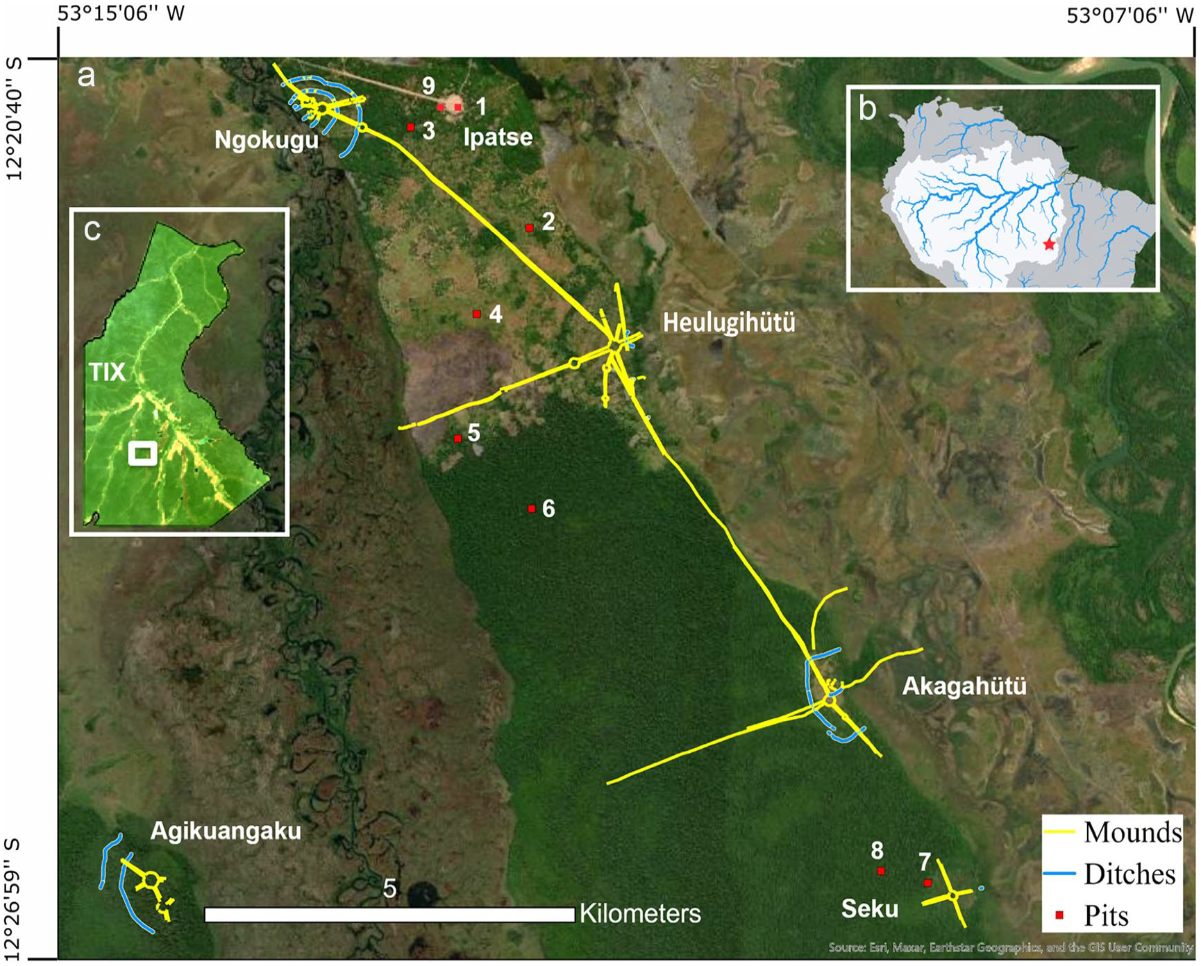
Map of the study area. (a) The location of soil pits 1–9 in relation to the contemporary Kuikuro village of Ipatse and archaeological sites (villages, roads and ditches). (b) Location of area A within the Xingu Indigenous Territory (TIX), located in Mato Grosso state, Brazil. (c) Location of the Xingu Indigenous Territory within the Amazon basin.
Pit 1 was excavated in the middle of the plaza pertaining to the previous Ipatse village. This was an area dominated by sparsely-scattered grasses that underwent regular (sub-annual) cleaning during the 38 years in which the village was active. Pit 2 was located within a pequi orchard (pequizal) belonging to Lümbu Kuikuro which was once a manioc field planted with pequi trees 36 years ago. The Kuikuro burn this area annually to remove weedy understory growth. Pit 3 was excavated in a former manioc field that was fallowed over 15 years ago and is in an intermediate state of recovery, being dominated by scrubby vegetation. Pit 4 is in a former manioc field opened by Tabata Kuikuro in 2002 which is in an early state of managed recovery that includes regular burning. The understory is dominated by sapé (Imperata brasiliensis), a Panicoideae grass that invades fields and is harvested in large quantities for roof thatch. Pit 5 was located in an active (2 years-old) manioc field belonging to Yahila Kuikuro that was still planted with manioc at the time of sampling. Pit 6 is in old-growth forest (itsuni) adjacent to this area of swidden fields which has suffered wildfire incursions during the last two decades. In this context, we use the term ‘old-growth forest’ to describe forests that are in a state of ecological climax, regardless of whether or not they were disturbed in the past. Pit 7 is in itsuni located 8 km away from Ipatse village, 400 m away from the Seku archaeological site, and on the edge of a former manioc field. Pit 8 is in itsuni located 1 km from the same site whose surroundings have not undergone modification in living memory. We also included samples from a 25 years-old kitchen midden (Pit 9) belonging to Yahila Kuikuro and located in the previous Ipatse village to test the phytolith signature of modern waste disposal activities.
Sampling method
Contemporary indigenous occupations in the TIX are superimposed upon a dense network of pre-Columbian archaeological sites. Ipatse village itself is located just 1 km from the fortified village of Ngokugu and 4 km from the ceremonial centre Heulugihütü, both of which are connected by a pre-Columbian road that runs nearby Pits 4 and 5 (see Figure 2). Pits 7 and 8 are located, respectively, 400 m and 1 km away from the Seku archaeological site, southeast of Ipatse. Since this paper focuses on modern land-use signals, we present data from the top 20 cm of the pits, as previous studies have shown that phytoliths and charcoal encountered at these depths are representative of post-colonial activity (post-AD 1500) (Bush et al., 2008; McMichael et al., 2012a, 2012c; Watling et al., 2017a).
Sampling in the field was made from excavated soil profiles, a strategy that allowed us to record the soil stratigraphy at each sampling location, check for the presence of charcoal lenses that could indicate in-situ burning events, and avoid areas of obvious bioturbation while sampling. A sampling resolution of every 5 cm was used to test whether there were any finer temporal patterns detectable in the off-site phytolith and charcoal signatures that could otherwise be obscured by sampling every 10 cm (sensu Heijink et al., 2020, 2023; Iriarte et al., 2020; Piperno et al., 2021) or 20 cm (sensu McMichael et al., 2012b; Piperno et al., 2015). We do this by averaging the proxy data over these different depth intervals and presenting the results alongside our data.
Charcoal analysis
Charcoal extraction and analysis followed the protocol of McMichael et al. (2012b). About 5 cm3 of soil was measured volumetrically in water and left to deflocculate overnight in a solution of 3% H2O2. The sample was then sieved through a 500 µm mesh and transferred to a gridded petri dish for analysis under a Leica S9i binocular loop microscope. The surface area of charcoal particles was measured using Image J software fitted with the plugin CharTool, which allows for particle measurement using a live video image (Snitker, 2020). Surface area measurements (mm2/cm3) were converted into volume (mm3/cm3) by applying the equation volume = area^(3/2) (Weng, 2005). This has the effect of downweighting the importance of smaller charcoal fragments to the total sum.
Phytolith analysis
The very high iron oxide content of the region’s Oxisols meant that a special laboratory protocol had to be applied for the successful extraction and quantification of phytoliths. After several rounds of testing, we applied a version of the ultrasonic bath method (Lombardo et al., 2016) that added an extra step for oxide removal through the dithionite-citrate-sodium bicarbonate method (Calegari et al., 2013; Mehra and Jackson, 1958). This protocol has been applied successfully in similar cerrado soils in Brazil, where it performs better than other methods in terms of the number and variety of phytoliths extracted (Calegari et al., 2013). A step-by-step description of the method is as follows: (1) Samples are deflocculated by treatment in 5% sodium hexametaphosphate heated to 60°C with 15 min of sonication; (2) Carbonates are removed using a solution of 10% HCl; (3) Samples are wet-sieved at 250 µm to remove large particles; (4) Organic matter is removed by heating samples in a solution of 30% H2O2 up to 60°C. Samples are sonicated for 30 min every hour until the reaction ceases and washed with a sodium acetate solution prepared to pH 5 to remove soil cations; (5) Oxides are removed by heating samples to 75°C in a solution of 8:1 sodium citrate (0.3 M) to sodium bicarbonate and adding 1 g of sodium dithionite every 5 min for a total of 15 min. Tubes are then completed with saturated sodium chloride and centrifuged. This stage must be repeated until the supernatant is a greyish white colour; (6) Clays are removed through centrifugation and samples are dried at 105°C for 8 h; (7) Phytoliths are separated from the soil matrix using sodium polytungstate (2.3 g/cm3), washed, and dried again at 105°C for 8 h; (8) Residues are mounted onto microscope slides using Entellan mounting medium.
We did not sieve the soil samples into their respective silt and sand fractions, as is sometimes practiced (Piperno, 2006). In a preliminary test conducted in 2018 with 24 soil samples taken from different contexts in and around Ipatse village (forest soils, dark earths, etc.), not a single sand fraction sample contained phytoliths, leading us to leave out the procedure. An absence of sand-sized phytoliths in soils is not uncommon and has to do with the phytolith production patterns of the plant species endemic to the region (Dickau et al., 2013; Watling et al., 2016).
At least 200 phytoliths were counted using a Leica D750P microscope under 400× and 630× magnification. Taxonomic identifications were made by comparisons with published atlases (e.g. Chen and Smith, 2013; Morcote-Ríos et al., 2016; Piperno, 2006; Piperno and McMichael, 2020; Piperno and Pearsall, 1998; Watling and Iriarte, 2013; Watling et al., 2020) and the modern plant reference collection housed at the Microarchaeology Laboratory at the Museum of Archaeology and Ethnology, University of São Paulo (available online at www.reftropica.com). Wherever possible, phytolith nomenclature followed norms presented in the ICPN 2.0 (ICPN, 2019).
Human impact indicators
In soil phytolith studies, the percentage of morphotypes belonging to early successional herbs (ESHs) – namely Panicoideae and Chloridoideae grasses and the genus Heliconia – is employed as an indicator of anthropogenic forest disturbance in the past. The same is true of palm (Arecaceae) phytoliths, which are important indicators of cultural and managed landscapes, and burned phytoliths, identified by their black to brown colour. While there is evidence to suggest that phytolith discolouration can occur due to factors other than burning (Parr, 2006; Watling et al., 2020), we nevertheless quantified them due to their importance in the present discussion. Most of the following results section thus focuses upon patterns in ESH, palm and burned phytoliths in the assemblages.
Results
Figure 3 shows percentages of ESH, Arecaceae and burned phytoliths and charcoal volume recovered in the soil pit samples. Full raw data tables can be accessed in the Supplemental Materials, available online.
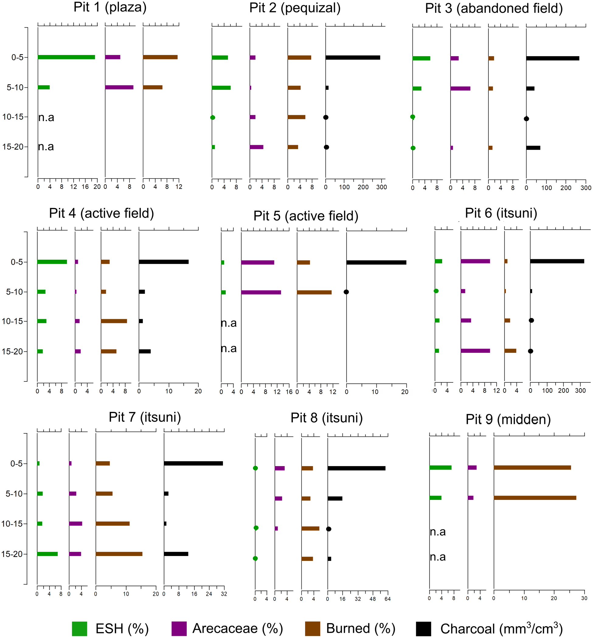
Graph showing phytolith and charcoal data by depth (cm). n.a.: sample data not available.
Charcoal results
Charcoal volumes ranged from 0.53 to 323.75 mm3/cm3 within individual 5 cm samples. Charcoal data was unavailable for Pits 1 and 9 (village plaza and midden) due to these samples having been granulometrically separated (<500 µm) prior to analysis.
Charcoal was overwhelmingly more abundant in the 0–5 cm samples than in sub-surface samples. In the manioc fields and pequizal, this is consistent with modern vegetation clearance and plot maintenance for cultivation. However, the same pattern is also observed in all of the itsuni pits, including Pit 8, which is located some hundreds of metres away from any known modern land-use. Charcoal volume also rose sharply in the basal (15–20 cm) samples of Pits 3 (abandoned field), 4 (active field) and 7 (itsuni), multiplying by between 9 and 16 times in relation to the 10–15 cm samples.
Table 1 ranks the soil pits according to their charcoal content. A broad overall correlation between land-use intensity and surface charcoal volume can be suggested: the pequizal contained more charcoal than the abandoned field, which contained more charcoal than the active fields. However, the surface sample that contained most charcoal was from itsuni (Pit 6), and Pits 7 and 8 (also itsuni) both contained more surface charcoal than the active fields. Potential reasons for this are given in the discussion.
Pits are ranked according to charcoal content in the 0–5 cm surface samples (measured in mm3 charcoal/cm3 of soil). Charcoal volumes for the pits are then averaged over 10 and 20 cm and the percentage difference in volume calculated in relation to the surface sample.

When the surface charcoal volumes are averaged over 10 or 20 cm to simulate coarser sampling strategies, the pits largely maintain their initial ranking, but charcoal values drop by between 37% and 48% and 61% and 74%, respectively, reflecting the fact that most charcoal in the pits is constrained to the 0–5 cm sample. The abandoned field (Pit 3) changed to rank the highest when charcoal values were averaged over 20 cm due to the increase in sub-surface charcoal at that location.
Phytolith results
Table 2 ranks the soil pits based on percentages of ESH, Arecaceae and burned phytoliths in the 0–5 cm assemblages.
Pits are ranked according to ESH, Arecaceae and burned phytolith content (measured in percentage of total assemblage). These values are then averaged over 10 and 20 cm and the percentage difference calculated in relation to the surface sample.

Early successional herb phytoliths
With the exception of one Heliconia sp. phytolith encountered in Pit 6 (itsuni), and the rare presence of Chloridoideae saddle phytoliths, ESH phytoliths consisted exclusively of Panicoideae short cells (bilobates, crosses and polylobates). Several of the pits contained phytoliths from the Bambusoideae subfamily, but these were not included in the ESH count because several of its members are common understory components of tropical forests. Other grass phytoliths such as rondels and bulliforms that cannot be securely assigned to non-bamboo grasses were also left out of the ESH count.
ESH phytolith percentages broadly reflected gradients in land-use intensity. They were most abundant in surface samples from the village plaza (Pit 1) where they made up 19% of the phytolith count, followed by an active field (Pit 4, 10%), the kitchen midden (Pit 9, 7%), the abandoned field (Pit 3, 6%) and the pequizal (Pit 2, 5%). In all the itsuni old growth forests ESH phytoliths made up <3% of the total, while the youngest active field (Pit 5) contained <1% ESH phytoliths.
In areas of most intensive current land-use (Pits 1–4), ESH phytoliths were seen to drop off sharply in the subsurface samples (5–20 cm), while remaining more constant with depth in the old growth forests (Pits 6–8). In Pit 7 (itsuni), ESH phytoliths were most abundant in the 15–20 cm sample, climbing to 7% of total from previous values of 1-2%. These stratigraphic differences are reflected in the different effects that averaging these values over 10 or 20 cm has on the phytolith percentages. When averaged over 10 cm, the pits largely maintained their initial ranking, with the largest percentage differences (+70%) occurring on the smallest values and thus not affecting the overall results. Averaging over 20 cm introduced larger variation in the results (−59% to +220%) and the ranking no longer reflected the modern land-use gradient.
Arecaceae phytoliths
Surface palm phytolith percentages did not show a clear correlation with modern land-use intensity (Table 2). Palms total <3% in surface samples of Pit 7 (itsuni), Pit 4 (active field), Pit 2 (pequizal), Pit 3 (abandoned field) and Pit 9 (midden), and reach ⩾10% only in Pits 5 (active field) and 6 (itsuni). In Pits 5 and 6, this trend is driven by conical phytoliths of the Bactridiinae tribe, most likely from Acrocomia aculeatum (macaúba) which is the most ubiquitous species in the region.
A substantial subsurface increase in palm phytoliths (from 4% to 10%) was observed in the basal sample (15–20 cm) of Pit 6 (itsuni), driven by conical phytoliths, and smaller increases with depth (from 1% to 4%) in Pits 2, 4 and 7, driven by a mixture of conical and spheroid echinate phytoliths. It is interesting to note how more gradual increases in palm phytoliths with depth result in higher percentage values when the data are averaged over 10 and 20 cm, while the more abrupt subsurface increase in Pit 6 is completely diluted.
Burned phytoliths
Burned phytoliths were by far most abundant in the surface sample of the kitchen midden (Pit 9, 25%), followed by the village plaza (Pit 1, 12%). All other surface samples contained ⩽10% of these phytoliths. As noted with the palm phytoliths, the ranking of the pits in Table 2 does not clearly reflect land-use intensity. For instance, burned phytolith percentages in the surface samples reached 8% in Pit 2 (pequizal), 5% in Pit 7 (itsuni) and <2% in Pit 3 (abandoned field) and Pit 6 (itsuni). Subsurface increases in burned phytoliths were observed between 10 and 15 cm in Pit 4 (active field) (from 2% to 9%), between 10 and 20 cm in Pit 7 (itsuni) (from 6% to 16%) and between 5 and 20 cm in Pit 6 (itsuni) (from 0.5% to 4%). Meanwhile, percentages of burned arboreal phytoliths only reached substantial values in the midden (Pit 9, 23%), and ranged between 0% and 6% in all of the other surface samples.
When burned phytolith values were averaged over larger depth intervals, once again the pits largely maintained their initial ranking, and the largest percentage differences mainly occurred on the smallest values. In the case of Pit 7 (itsuni), however, the subsurface increase in burned phytoliths was enough to double their percentage total once averaged over 20 cm.
Looking at the proportion of phytoliths from different taxonomic groups that were burned (Figure 4), in almost all cases, Panicoideae and Arecaceae phytoliths were much more often encountered burned than woody phytoliths and phytoliths produced by non-Panicoideae grasses or other herbs. These phytoliths often made up a small proportion of the total assemblages, however, suppressing their importance in the total burned phytolith counts.
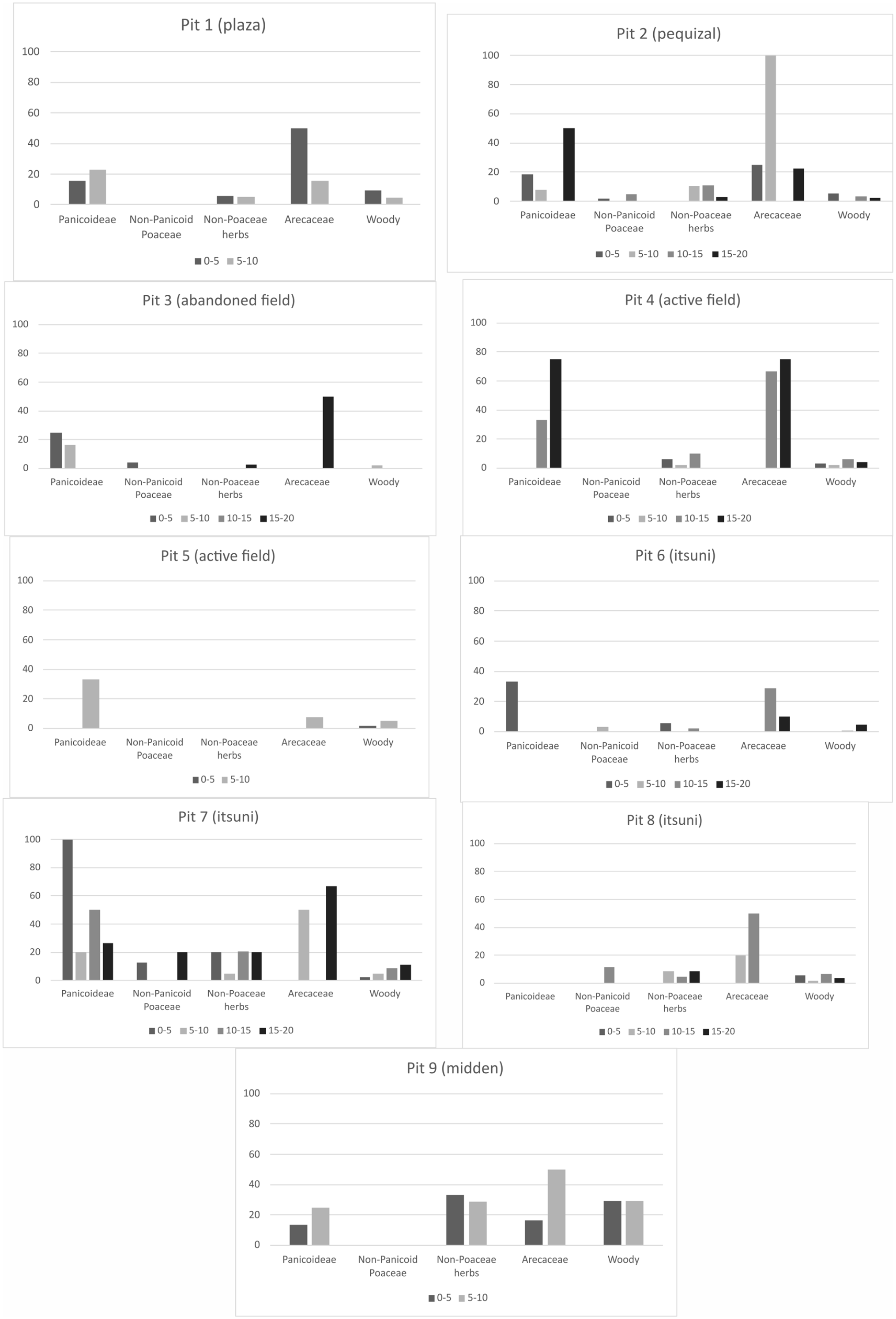
Figure showing percentages of phytoliths from different taxonomic groups that were burned, by soil pit and sample (depth).
Crop phytoliths
The only samples in the study to contain phytoliths from domesticated crops were those from Pit 9, the kitchen midden, which contained troughed phytoliths diagnostic of banana (Musa sp.). Manioc phytoliths were absent from the midden and from all the field samples analysed.
Discussion
While this study is by no means an exhaustive treatment of land-use signals in the Upper Xingu, the results reported herein have important implications regarding the use of soil phytolith and charcoal data to detect past human impact on the environment in the region, and in the Amazon more generally.
Charcoal and ESH phytoliths conform most closely to land-use intensity
While we maintain that soil charcoal content, and ESH, Arecaceae and burned phytoliths are good indicators of human activity, these proxies did not always behave concomitantly with one another or according to the gradient of land-use intensity broadly captured by the soil pits.
Of the four proxies, charcoal volume and ESH phytoliths showed the strongest relationships to modern land-use intensity, and cases that did not conform to this rule can be explained fairly easily. For example, the fact that an itsuni surface sample (Pit 6) yielded the highest volume of charcoal in the study likely reflects the fact that the forest at this location has suffered from many episodes of accidental burning over the past two decades – an unwelcomed effect of regional climate change. Though it is surprising that charcoal volume in this pit would be comparable to the pequizal, which has been intentionally burnt for 36 years, it is possible that factors such as high initial fuel load (since they are uncontrolled fires), or uneven charcoal deposition across the forest floor, may account for this result. We reiterate that we did not analyse charcoal from multiple points within the same sampling location, as other studies have done (McMichael et al., 2012a, 2012b, 2012c). Furthermore, the burning activity recorded in Pit 7 (itsuni), which ranked higher than both active fields in charcoal volume, is likely associated with the former Kuikuro field that once existed close to this sampling location.
The high percentage of ESH phytoliths in the village plaza (Pit 1) is to be expected since this area was kept clean of vegetation and, like the midden location (Pit 9), likely receives Panicoideae phytolith inputs from decomposing house thatch. The difference in ESH values between the two active fields (10% in Pit 4 compared to 1% in Pit 5) is also explained by the fact that sapé grasses dominate the Pit 4 location and are encouraged to grow there through regularly burning, whereas the Pit 5 field had only been open for 2 years and was free of weedy growth at the time of sampling. An additional 15 years of field management at the Pit 4 location also accounts for the higher charcoal volume recorded there.
It is curious to note that the surface sample of Pit 5 (active field) ranked first place for Arecaceae phytoliths, since today there are no members of this family growing in this locale. The most likely explanation is that this signature comes from the vegetation that was cleared to open the field which, coincidentally, is not far from an itsuni location (Pit 6) that ranked second for Arecaceae. Neither Arecaceae nor burned phytoliths clearly reflected gradients in current land-use intensity. Palms, in general, do not appear to be as prominent in the transitional forests of the Upper Xingu as they are in more humid western regions of the Amazon basin, reflecting the correlation between moisture availability and palm species richness in the tropics (Salm et al., 2007). Palm species most used by the Kuikuro include buriti (Mauritia flexuosa), which grows exclusively in lakes and wetlands, macaúba (Acrocomia aculeatum), which grows in fallow fields and on the anthropogenic soils of abandoned villages, and tucum (Astrocaryum sp.), which must be sought for far from the village.
The burned phytolith data from this study raise questions over the conditions under which these phytoliths form. Observing how the samples rank in Table 2, there may be a relationship between fire frequency and burned phytolith percentages – the village plaza and pequizal are areas burned annually or sub-annually, and rank second and third after the midden (Pit 9), a locale where organic waste is burned daily and charcoal from domestic fires is dumped (Schmidt, 2013; Schmidt et al., 2009). In surface soils from modern slash-and-burn fields in Panama, Piperno (2006) reported frequencies of burned arboreal phytoliths of between 30% and 70%. In our study, similar values were only reached in the midden samples (Pit 9). By contrast, active and abandoned fields contained between 0% and 6% burned arboreal phytoliths. This pattern might reflect the more frequent use of low-temperature surface burns to eliminate weedy species in Kuikuro management practices, however, the question remains as to why significant quantities of burned phytoliths were not produced during initial forest clearance for the cultivation of these fields. The data suggest that phytolith burning can differ substantially depending on cultural or environmental context, where factors such as burn type, burn temperature and oxygen availability, experimentally shown to affect phytolith burning (Parr, 2006), may vary.
Finally, the absence of manioc phytoliths in this study is surprising given that four of the pits were located in active or former manioc fields. Although manioc phytoliths are produced in low quantities in the leaves and root rind of the species, and are also small and difficult to identify, their absence in the soil pits – particularly the midden – deserves further investigation. Since the Kuikuro tend to plant other crops such as maize and squash (which produce abundant phytoliths) in house gardens or areas of anthropogenic soils, we cannot rely on these species as indicators of swidden fields in off-site soil pit records.
Finer sampling resolution can reveal temporal patterns that would otherwise be obscured
Our study has demonstrated that considerable heterogeneity in phytolith and charcoal signatures can occur within 5 cm sampling intervals which could be obscured, or even missed, when sampling is conducted over larger depth intervals.
The often-dramatic increases in charcoal, and to a lesser extent ESH phytoliths, in the 0–5 cm samples of the soil pits are best interpreted as representing current land-use signals, while subsurface increases in these proxies show a relationship to their proximity to archaeological sites. In Pit 7, a peak in Arecaceae phytoliths between 5 and 15 cm and increases of ESH and burnt phytoliths with depth are most parsimoniously associated with late pre-Columbian land-use, given that the sampling location is just 400 m away from the Seku archaeological site, with two available dates ranging from cal. AD 1492 to 1646. A charcoal increase is also observed between 15 and 20 cm in Pit 3 (abandoned field) which is located just 1 km away from the Ngokugu site, securely dated to cal. AD 1000–1700 (Heckenberger, 2005). While soil pits cannot be treated the same as laminated lacustrine records due to the vertical mixing of phytoliths and particulate charcoal, these results support the presence of an overall age-depth relationship of proxy data within the top 20 cm of soil.
While sampling over 5 cm intervals was far better able to pick out these trends, 10 cm sampling intervals still gave more coherent results, and better reflected land-use gradients, than 20 cm intervals.
The use of cut-off points for ‘present’ human activity has likely underestimated pre-Columbian land-use in Amazonia
In several impactful publications measuring human impact in Amazon forests, ESH phytoliths have been considered ‘significant’ if they reach values of ⩾10%, while values of <10% have been interpreted as evidence of forest canopy maintenance and thus an absence of human impact (McMichael et al., 2012a, 2012b, 2012c, 2015a; Piperno et al., 2015). The same baseline of 10% has also been more loosely applied to interpret Arecaceae and burned arboreal phytolith counts (McMichael et al., 2012b; Supplemental Fig. S1, available online). Meanwhile, charcoal volumes of >0.25 mm3/cm3 have been seen as representing ‘present’ charcoal (in situ burning events) and <0.25 mm3/cm3 as representing ‘trace’ charcoal (extra-local burning or absent human impact at that location) (McMichael et al., 2012b, 2012c).
While the charcoal content of all the samples in this study exceeded the threshold for ‘present’ burning (⩾0.25 mm3/cm3), very few of the samples from our modern land-use spectrum contained what would be considered ‘significant’ ESH, Arecaceae and burned arboreal phytoliths.
Among the pits containing ‘trace’ values of these phytoliths is the pequizal – a former manioc field that was transformed into a pequi orchard which has been managed and regularly burned by the Kuikuro for over 35 years. Pequi does not produce phytoliths, while frequent surface burns probably mitigate the build-up of early successional herbs. This result echoes previous concerns regarding the visibility of certain types of anthropogenic forest in soil phytolith records (Clement et al., 2015b; Stahl, 2015; Watling et al., 2017b).
As our sample size of Kuikuro land-use areas increases in the future, it will be important to test whether fields and pequizais will be able to be detected using multivariate statistical approaches. In the meantime, it is clear that applying the same cut-off points in the Upper Xingu would lead to an underestimation of past human land-use. Instead, the proxy data must be compared locally and on their own terms.
Conclusion
This study presents one of the first attempts to quantify charcoal and phytolith data from current indigenous land-use areas and assess their implications for identifying pre-Columbian human impact in Amazon forests. Firstly, we have demonstrated how early successional herb (largely Panicoideae) phytoliths and charcoal volumes echo overall gradients of land-use intensity, while palm and burned phytolith frequencies are associated with land-use patterns in more complex ways. There is preliminary evidence to suggest that the overall proportion of burned phytoliths in an assemblage may be related to burn frequency, while (as suggested by McMichael et al., 2012b), the type of burn (i.e. surface vs canopy) likely affects which types of phytoliths become discoloured (i.e. herb vs arboreal).
Secondly, we have shown how using 5 cm sampling intervals is effective for identifying finer temporal trends in proxy data, and how the use of coarser sampling (especially over 20 cm intervals) can have the effect of diluting human land-use signals.
Lastly, we suggest that previous use of phytolith cut-off points to identify ‘present’ anthropogenic landscape modifications has likely had the effect of underestimating past human impacts in the Amazon basin, especially when combined with coarser sampling strategies.
Since this is the first investigation into phytolith and charcoal signals from Amazonian indigenous land-use, its results are of an exploratory nature and must be complemented by data from other regions of the basin. Just as present-day landscapes and biodiversity cannot be understood without knowledge of the millennial-scale processes that formed them, palaeoecological methods cannot accurately reconstruct past landscapes without employing data from relevant modern analogues. The need for more collaborative, local research is amplified by the implications that these studies have for conservation policy and for how indigenous lifeways, knowledge and biocultural heritage are perceived and valued (Clement and Junqueira, 2010; Neves et al., 2021).
Supplemental Material
sj-xlsx-1-hol-10.1177_09596836231183066 – Supplemental material for Assessing charcoal and phytolith signals for pre-Columbian land-use based on modern indigenous activity areas in the Upper Xingu, Amazonia
Supplemental material, sj-xlsx-1-hol-10.1177_09596836231183066 for Assessing charcoal and phytolith signals for pre-Columbian land-use based on modern indigenous activity areas in the Upper Xingu, Amazonia by Jennifer Watling, Morgan Schmidt, Michael Heckenberger, Helena Lima, Bruno Moraes, Kumessi Waura, Huke Kuikuro, Taku Wate Kuikuro, Utu Kuikuro and Afukaka Kuikuro in The Holocene
Footnotes
Acknowledgements
We thank the residents of Ipatse village for their help conducting this research, particularly Yahila, Lümbu, and the late Tabata, for allowing us to sample their fields.
Ethics
Fieldwork and sample collection in the indigenous territory was carried out in 2019 with permission from the National Indian Foundation [FUNAI, 08620.000250/2018-91], the National Institute of Historic and Artistic Heritage [IPHAN, 01425.000070/2018-77], and the Kuikuro Indigenous Association (AIKAX).
Funding
The author(s) disclosed receipt of the following financial support for the research, authorship, and/or publication of this article: This work was supported by a Young Researcher Award from the São Paulo Research Foundation [2017/25157-0 and 2018/19152-9, to JW], and the National Science Foundation Archaeology Programme [BCS 0004487, 0353129, and 1660459 to MH], and the Willian Talbott Hillman Foundation. Research in Brazil was sponsored by the National Museum of Brazil (Rio de Janeiro) and the Emílio Goeldi Museum (Belém). Additional support for the project was provided by the Pennywise Foundation.

Supplemental material
Supplemental material for this article is available online.
References
Supplementary Material
Please find the following supplemental material available below.
For Open Access articles published under a Creative Commons License, all supplemental material carries the same license as the article it is associated with.
For non-Open Access articles published, all supplemental material carries a non-exclusive license, and permission requests for re-use of supplemental material or any part of supplemental material shall be sent directly to the copyright owner as specified in the copyright notice associated with the article.
