



Abstract
In this article we describe and interpret disturbances in the sedimentary records of four lakes on the western flank of Lake Imandra (NE Fennoscandia, Kola Peninsula). The research framework comprises sedimentological and textural criteria for a visual description of sedimentary structures sediment core data, chronological (radiocarbon dating) data, and ground-penetrating radar (GPR) data. Disturbances preserved in lake sequences contain a mixture of chaotic fragments of sand, silt, polychromatic gyttja, peat, and wood fragments embedded in the organogenic matrix. The synchronicity of disturbances, fast sediment accumulation in lakes, relationship with Quaternary faults, the observed mass movements in lake sediments are interpreted as potential consequences of the earthquake shaking. A seismic event with a magnitude Mw no less than 4.5–5 and intensity of shaking I0 = IV–VI took place in the Middle Holocene, 6400–6100 cal. yr BP. Our studies show that although this area is not seismically active today, some of the main fault zones experienced short periods of reactivation also in the postglacial time, when glacioisostatic rebound after the ice retreat was already very low.
Introduction
In recent decades, paleolimnological studies have become quite widespread worldwide, including in the circumpolar regions (Krikunova et al., 2022; Lenz et al., 2021; Melles et al., 2012; Rantala et al., 2015). This growing interest arises from the fact that lacustrine sediments are a great source of information concerning different environmental changes including the Holocene tectonic settings and strong catastrophic events (earthquakes, tsunamis, landslides) (Doig, 1999; Masson et al., 2006; Morey et al., 2013; Schnellmann et al., 2006; Strasser et al., 2007; Кeefer, 1984). Lithostratigraphic evidence of earthquakes in aquatic environment includes displacement of on-shore and offshore strata, such as mass transport deposits, earthquake-triggered slump, homogenites, flood-induced turbidites, breccias, stratigraphic non-conformities. Disturbances in lacustrine records associated with strong earthquakes have been documented not only in seismically active areas and subduction zones but also in regions of moderate or low seismicity (Chapron et al., 1999; Guyard et al., 2007; Lajeunesse et al., 2017; Monecke et al., 2006; Ojala et al., 2019).
The Kola Peninsula is located in the Russian part of the North-Eastern Fennoscandian Shield (Figure 1a). It is surrounded by the Barents Sea from the north and the White Sea from the south. This area is the largest representative of the Early Precambrian crystalline basement of the East European Craton, composed of ancient rocks of the crystalline shield exposed as a result of a long vertical uplift (Mitrofanov et al., 2002). The bedrock is represented by mostly gneisses, granite-gneiss, and amphibolites that were metamorphosed several times in the Archean and Paleoproterozoic. The area was covered by the Scandinavian Ice Sheet during the late Weichselian leading to the deposition of till and glaciofluvial deposits during deglaciation, that finished in the Early Holocene 11,500–9500 cal. yr BP (Yevzerov and Nikolaeva, 2000). Holocene deposits are represented by lacustrine, marine, alluvial and peat sediment (Niemela et al., 1993). The sedimentary cover of the Kola region is thin, reaching 100 m in thickness in some depressions and deep valleys.
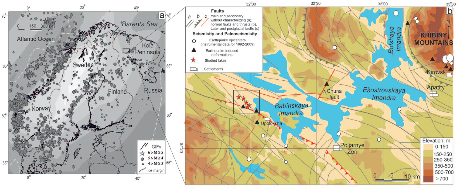
Earthquakes and glacially-induced faults (GIFs) in the Fennoscandian Shield (a), and map showing the Lake Imandra basin, surrounding topography and the lakes discussed in the paper (b). a: Earthquake epicenters (stars and circles) during 1971–2014 from FENCAT (2020), GIFs (black lines) according to Munier et al. (2020). The light gray dashed line shows the maximum ice margin at Last Glacial Maximum (Wu et al., 2021). On the map (b), a square shows the position of Figure 2.
As the eastern periphery of the Fennoscandian Shield the Kola Peninsula has long been considered as a low seismic activity area (FENCAT, 2020; Godzikovskaya et al., 2010). Almost all of the modern earthquake epicenters in this region were located at shallow crustal depths within the 5–25 km range. The magnitudes (Mw) of those earthquakes were usually about 2–4, very rarely exceeding 4.6 (Figure 1a). Although the instrumentally recorded seismicity at the Kola Peninsula during the last 50 years is extremely low, the historic earthquake catalog indicates several damaging earthquakes during the last 1000 years. The strongest earthquake in this area was the one of 1627, which had a magnitude Mw = 6.5 and occurred in the Kandalaksha graben in the White Sea (Nikonov, 2004).
The situation changed at the beginning from the second half of the 21st century, when the evidence of strong ancient earthquakes (intensity I0 ⩾ VIII–IX, magnitude Mw = 7.0 ± 0.5) started to appear over the entire Fennoscandia (Kukkonen et al., 2010; Lagerbäck and Sundh, 2008; Mattila et al., 2019; Mörner, 2004; Nikolaeva, 2008; Olesen et al., 2013; Smith et al., 2014; Sutinen et al., 2018). Most often these earthquakes occurred at the last stage of the glacial age (~9500–12,000 years ago) during the intense postglacial isostatic uplift of the Fennoscandia domain; the uplift rate at this period was ~3.5–10.5 cm/year in different areas of the domain (Stroeven et al., 2016).
However, seismic events in the aquatic environment have been rarely documented thus far. In western Fennoscandia, the most significant event was the giant catastrophic Storegga Slide, which triggered a widespread tsunami in the North Atlantic 8200–8000 cal. yr BP (Bondevik et al., 2003). Individual lake basins located near post-glacial faults of northern Finland contain layers with turbidites and deformations that are interpreted as seismically induced liquefaction and fluidization features and have an age of 9500–10,200 cal. yr BP (Ojala et al., 2019). The occurrence of a strong ancient earthquake in Russian Karelia (Mount Vottovaara area) around 10,000 cal. yr BP is attributed to the sedimentation gap and an abrupt change of dominant diatom species (Lukashov, 1995; Shelekhova and Lavrova, 2019). This implies a rapid decline in the water level of the lake. Sedimentary successions of a small lake, located in the western part of the Kola region, reveal seismically-triggered slumping from the slopes of the basin around 6000–7000 cal. yr BP (Nikolaeva et al., 2017). Tolstobrov et al. (2018) suggested that disturbed sedimentary structures in lacustrine deposits of small basins in the Murmansk coast of the Barents Sea were formed as a result of a tsunami which they dated to 10,400–8200 cal. yr BP and younger 8200 cal. yr BP.
The Murmansk region (Kola Peninsula) belongs to areas with a well-developed infrastructure, mining enterprises, and nuclear power facilities. Currently available seismic database of the Kola Peninsula is limited to instrumental recording, hence the insufficient reliability of predictions and risk estimates. The recurrence intervals of major earthquakes are often longer than those of instrumental and historical seismological records, although they are a key to better understanding of regional seismicity, and related seismic hazards.
In this article we investigate disturbances in the bottom sediments of four small lakes on the western shore of Lake Imandra (NE Fennoscandia, Russia) (Figure 1b) by combining ground-penetrating radar (GPR) data with detailed sedimentological core analysis and radiocarbon dating. The major aim of the work is to reveal and study the spatial distribution of disturbances in lake cross-sections and type and intensity of deformations. We also assess the dominant mechanism initiating the deformation process, identify seismogenic features in sediments, and determine the age of the event. Based on observations of paleo-earthquakes in Western Fennoscandia, the present paper discusses an irregular pattern of seismic activity during the last 10,000–11,500 years in stable areas previously covered by glaciers.
Study area
Geological and geomorphological setting
Lake Imandra is located in the extreme north-western part of the European territory of Russia in the Murmansk region, and fills a depression separating the Kola Peninsula from the mainland. Two differently directed branches, submeridional, Bolshaya Imandra, and sublatitudinal, Ekostrovskaya and Babinskaya Imandra embedded in Precambrian crystalline rocks, are tectonically predetermined and controlled by the morphostructure of the region. The studied lakes are located on the western shore of the Babinskaya Imandra subbasin that is a graben-like depression bounded by faults from the north and south (Figure 1b). In the study area the Late Archean gneisses are overlain by moraine, fluvioglacial, glaciolacustrine, and lacustrine deposits, as well as by peat deposits (Niemela et al., 1993). Large esker ridges stretching northwestward across the area for more than 20 km and sandy deposits of lake terraces of different heights (h = 3.5–13 m) are a noticeable feature of the local environment (Figure 2).
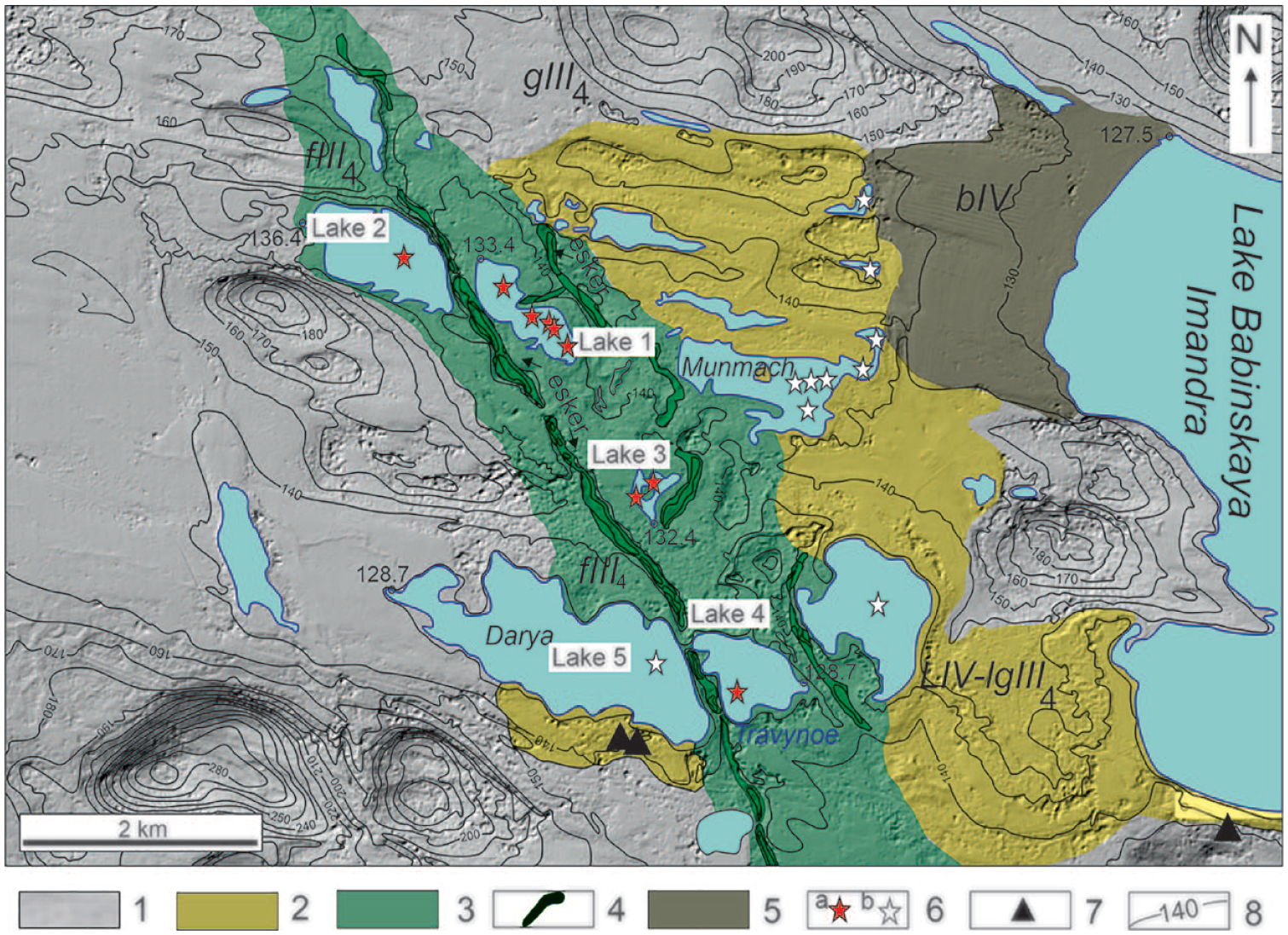
Location of the studied lake basins on the western shore of Lake Babinskaya Imandra. Surface model based on ArcticDEM data (Porter et al., 2018).
Paleogeographic conditions
According to numerous paleogeographic studies, the modern Lake Imandra was formed on the site of a periglacial basin referred to the Late Weichselian glacier (Armand and Samsonova, 1969; Korsakova et al., 2020; Nikolaeva et al., 2015). During the deglaciation and prior to the Younger Dryas (11,550 cal. yr BP) the glacier edge was situated in the Lake Imandra basin, thus covering the western part of Lake Babinskaya Imandra (Korsakova et al., 2020). In this period, the climate cooling was caused by the Scandinavian Ice Sheet readvancement and vegetation reduction (Lenz et al., 2021). At the end of the Preboreal the shore line of Lake Pra-Imandra was about 16–18 m higher than its modern level. From the Early Holocene the ice boundary moved back rapidly to the west. Lake level lowered, and isolated small basins were formed in a previously flooded area, having become the studied lakes 1–4 (Figure 2) (Korsakova et al., 2020, 2022; Nikolaeva et al., 2015). In the early Holocene, prior to c. 10 200 cal. yr BP, a relatively deep and cool water body with very low productivity existed in the Lake Imandra basin. Sparse birch phytocoenoses accompanied by metho- and hygrophilic herb assemblages occurred in the catchment in the interval of c. 10,200–9700 cal. yr BP. Pine forests with birch dominated here in the time span of c. 9700–8800 cal. yr BP, indicating relatively favorable climatic conditions.
Climatic records and palaeoenvironmental history of the central Kola region, indicate that regional Holocene thermal maximum occurred in the time interval of 8000–4600 cal. yr BP (Korsakova et al., 2022; Nikolaeva et al., 2015). During this period, the formation of sapropels and peat continued, and the processes of swamping of the territory were intense. Forests in the study area were dominated by pine and spruce which developed near the shores of lakes. The lakes looked like oligotrophic reservoirs, mostly with sandy, partially swampy shores.
By now the true altitude of the main basin of Lake Imandra is 127.5 m a.s.l. and that of detached lakes is 128.0–148.0 m a.s.l.
Active tectonics and seismicity
Manifestations of active tectonics on the shores of Imandra Lake included observations of uneven shoreline movement, recorded by flooding of peat bogs and disconnection of the lake terraces of the same altitude (Armand and Samsonova, 1969; Shvarev, 2003). The height difference of the terraced levels wash = 1–3 m. According to Shvarev (2003) lower terraces (h ⩽ 3.5 m) were formed under relative tectonic stability, while terraces of higher levels underwent the significant influence of tectonic movements.
The modern seismic activity of the territory is evidenced by weak earthquakes, the epicenters of which are localized in the Imandra Lake depression and on its sides, as well as in the Khibiny Mountains (Figure 1b). Since the 1960s, earthquakes with a magnitude Mw = 2–4 and have occurred in the Khibiny Moutains. The epicenter of the earthquake on June 26, 1996 (Mw = 2.8) with a focus depth of 16 km, was located beneath the bottom of Lake Imandra (Godzikovskaya et al., 2010). Traces of past strong earthquakes with an intensity I0 ⩾ VIII points on the MSK-64 scale were found in the study area and adjacent territories (Nikolaeva, 2022; Nikolaeva et al., 2018; Romanenko et al., 2011).
Materials and methods
Fieldwork
Fieldwork included a combination of ground penetrating radar surveys for Lake 1 and sediment core sampling for all four lakes. All the basins selected for coring were relatively small and located in gently sloping terrain. Table 1 shows the main characteristics of the studied lakes, their localization, and size.
Basic characteristics of the Lakes 1–4.

GPR survey. Three GPR profiles from Lake 1 (NW-SE) were made (Figure 3). The lengths of the GPR profiles were 340–520 m. To carry out the research, we used the GPR OKO-2 with an antenna unit with a center frequency of 150 MHz (Logis-Geotech). We made the fieldwork in winter by towing GPR on ice and recording the distance with an odometer. We registered the echo-signal in a time window up to 800 ns. The step of the GPR traces along the profile is 8 cm. All measurements were implemented with 32-fold stacking, which, as a notable experimental work, increased the stability of the record (Fediuk et al., 2022).
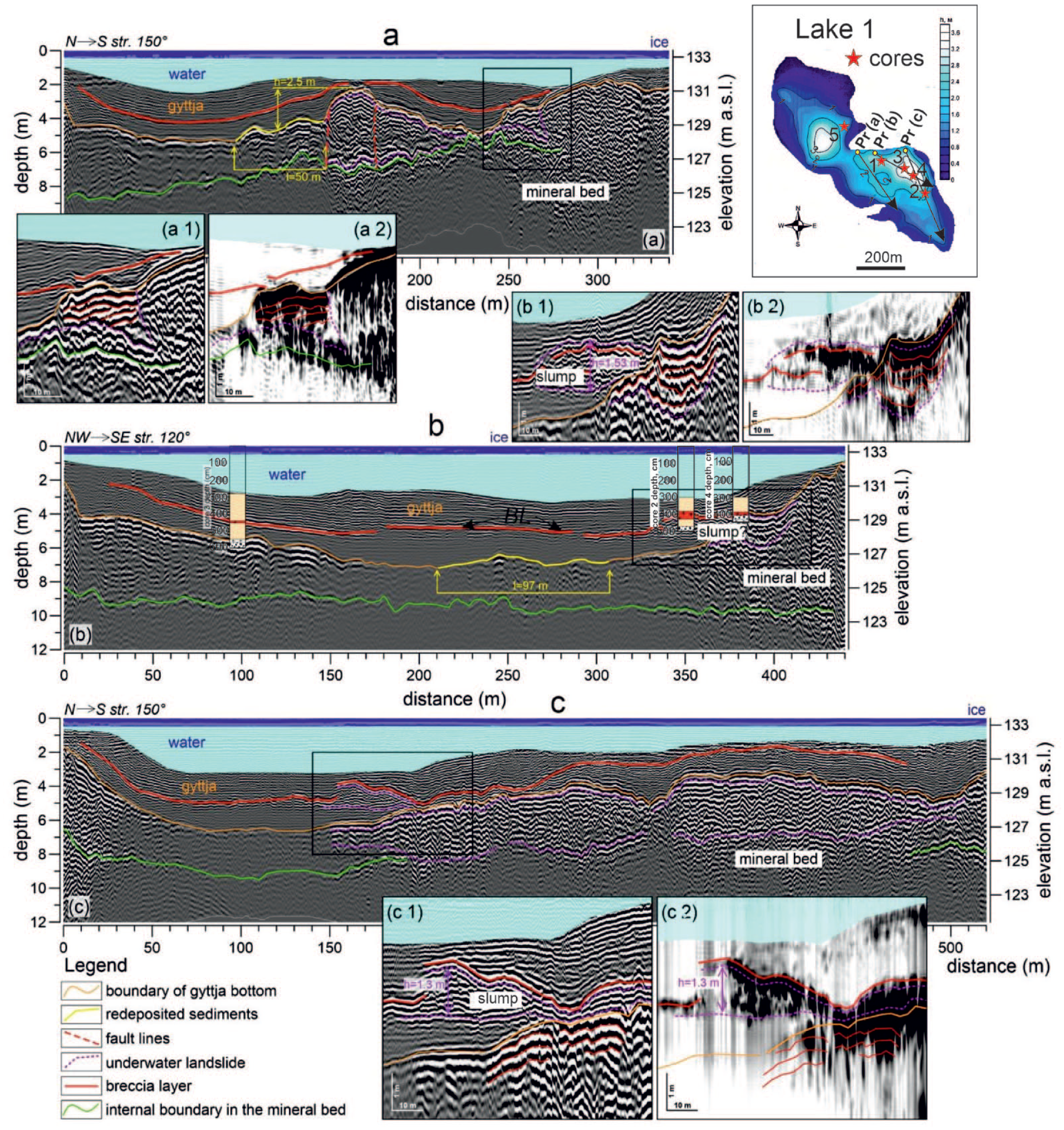
GPR cross-sections from Lake 1 were made according to survey profiles (a–c). Separate black box indicates discovered patterns for areas of washed sediment slump in the gyttja layer and their imaging on the radargram (1) and in envelope peak amplitude (2). Subhorizontal reflectors and high peak amplitudes characterized the boundaries of all sediment slumps. BL: breccia layer.
Initially, we carried out the processing of the GPR cross-sections from lakes. This is known, high-amplitude resonant reflections form when GPR survey doing from ice (Arcone et al., 2006). Therefore, the upper part of our received records was noisy up to times of 65 ns, and this required additional filtering of raw records. We carried processing of data out in the GeoScan32 software (Logis-Geotech). We used the main tools for processing GPR records: zero time correction; band-pass filter and mean subtraction (to remove DC offset and signal saturation); amplitude gain (to restore its own attenuation); and as a last stage picking of reflectors and velocity analysis (to delineation the sediment boundaries). As an addition to velocity analysis, we performed attribute analysis, as it improves signal parameters and facilitates interpretation. We calculated the instantaneous envelope of the reflected signal using the Hilbert transform, the amplitude peak of which was considered as the points of the highest signal reflection intensively. Next, we performed the recalculation from the time-section to the depth-section using velocity analysis and a multi-layer depth calculation. We identified four main separate layers, the velocities for which were assigned based on Moorman (2002) data. The first layer was ice at a velocity (V) of 13.4 cm·ns−1, the second was a water column at V = 3.3 cm·ns−1, the third was organic gyttja at V = 3.8 cm·ns−1, and the base layer was glacio-fluvial deposits at V = 6.7 cm·ns−1. As a result, we received GPR cross-sections with a fixed useful signal up to a depth of 12 m for studied lake. During the subsequent interpretation, we supplemented the sections with manual sampling columns. It should be noted that previously, GPR survey of the basin of Lake 1 have already been carried out, and this showed the existence of specific dislocations in sediments (Rodionov et al., 2018).
Coring. The four lake bottom sediments (Table 1) were sampling the floating catamaran during the summer periods of 2014–2016 (lakes 1 and 2) and in 2020 (lake 3 and 4) using a hand-operated piston corer 1 m length and 75 mm in diameter. Each core was noted to the depth from the surface in the lake, and the cores were taken with an overlap of 5–10 cm, which made it possible to obtain continuous sedimentary sequence. We pushed the equipment as far as we could, normally down to bedrock or glacial till.
The sediments were described in situ. Visually recognizable core attributes (color, texture, inclusions, mechanical composition) were studied to compose a lithological description of core and mark its stratum boundaries. The lake elevation was determined using topographical maps of 1:25,000 scale. Samples for 14C dating were picked from inside the selected horizon as well as from the overlying and underlying sediments. Thus we were able to estimate the age of an event or its lower and upper age limits.
Radiocarbon dating
Radiocarbon dating of 13 bulk organic sediment samples was processed in the Radiocarbon Laboratory of St. Petersburg State University using the conventional approach. Measurements and calculations of radiocarbon dates were provided according to the techniques described by Arslanov et al. (Arslanov et al., 1993). Radiocarbon dates were calibrated to calendar years using the OxCal 4.4 calibration program and the IntCal20 calibration plot (Ramsey, 2008; Reimer et al., 2020).
Results and interpretation
Stratigraphic units of the studied basins located on the western shore of Lake Babinskaya Imandra are classified according to the combined analysis of GPR data, sedimentological data, and chronological information.
GPR results
The basin of Lake 1 was asymmetric, its northern slope had an angle of up to 10°, and the southern angle was 2°. The maximum measured water depth was 3.4 m. For the lake, we identified two layers: mineral bed (sands) and organogenic layer (gyttja) (Figure 3). The gyttja thickness was 2.5–4 m. An additional intense reflector of unclear origin was found in the mineral bed, being possibly associated with the internal lithological boundary in the deposit.
Large hummocky bottom fragments up to 2.5 m high are revealed on the GPR profile (a) (Figure 3) of 340 m long in the southern parts of the bottom, along with the areas of sediment redeposition that indicate disturbances of the sedimentation process. We also established the position of the anomalous layer in the middle part of the gyttja, which lies conformably to the mineral bed of studied lake, but withal had a local gap at the level of 165 m and a depth of 2 m. According to well drilling data, as will be shown below, this is a breccia layer (BL) (Figures 4 and 5). Also the GPR profile (a), we identified an bottom fragment at elevations of 245–267 m with a thickness of up to 1.5, which differs in subhorizontal reflectors from the surrounding sediments with chaotic reflectors (Figure 3, a1 and a2). We interpret this fragment as a local landslide of liquefied soils.
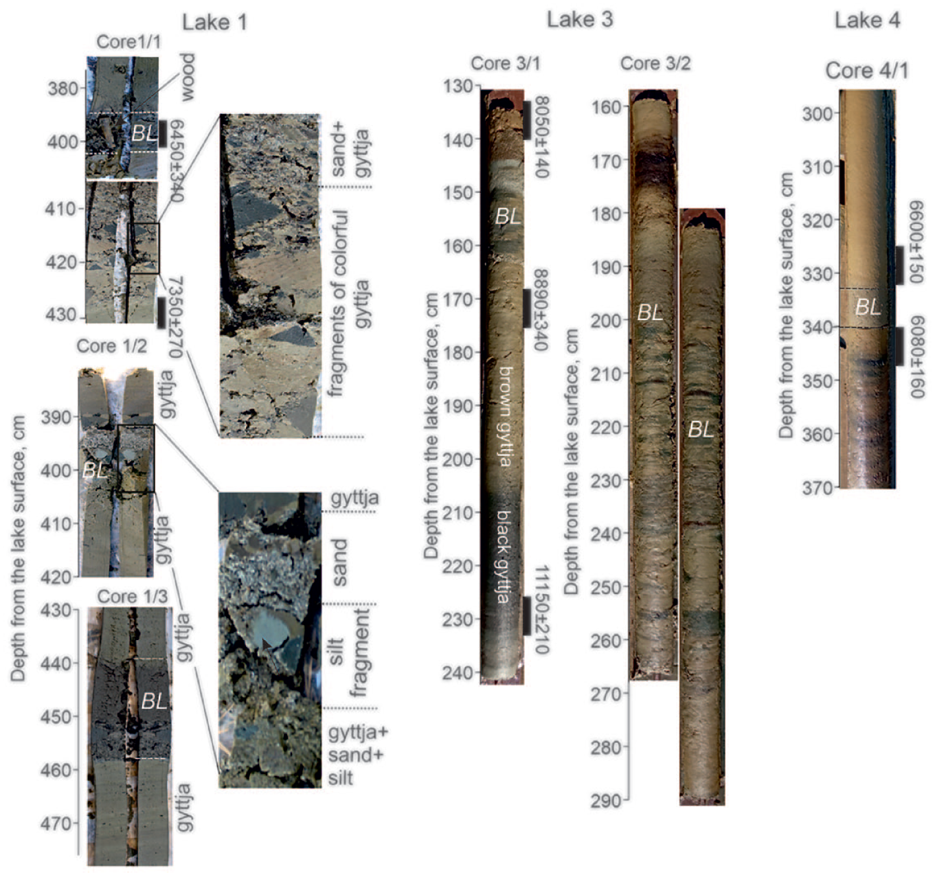
Photographs illustrating the breccia horizon in cores. Lake 1 cores show: fragment of wood with a length of 5 cm and diameter of 1.2 cm (core 1/1); mixed gyttja, sand and silt fragments (core 1/2); peat and plant residues contained in a sapropelic matrix (core 1/3).

Lithology logs of the bottom sediments cored in small lake basins 1–4.
On the GPR profile (b) at marks 340–410 m along the horizontal and intense reflectors, we founded a slump composed liquefied sands that were partially intruded into the gyttja layer (Figure 3, b1 and b2).
On the GPR profile (c), starting from the distance mark of 150 m, we found a layer under the gyttja, which was characterized wavy-hummocky reflectors and hyperbolas and was limited to clear-cut interfaces at the top and bottom. We interpreted this pattern as a large subaquatic slump 450 m long and 0.5–4.1 m thick (Figure 3, c1 and c2). Probably, the upper part of the slump was redeposited, since we identified extended horizontal GPR interfaces to a depth of 0.5–0.8 m, which was not typical for the main body of the landslide with a chaotic GPR pattern. At the level of 195 m, a sandy slump 1.3 m thick adjoins the upper boundary of the landslide, washed into the gyttja and overlain by a breccia layer, which repeats the sedimentary facies from other GPR cross-section (Figure 3b).
We also traced the breccia layer over a larger area of Lake 1, and its average depth was 3.6 ± 1.0 m (129.8 m a.s.l.).
Lithology and chronology
The 150–490 cm long successions from basins are composed of a sedimentary strata with two lithological units, the overlying gyttja and the underlying sands and silts. The gyttja is separated by a chaotic horizon (mixture of sand, gyttja, silt, and wood fragments) a 15 cm to 85 cm thick. This layer, which we called the breccia layer (BL), was found in lakes 1–4 (Figures 4 and 5).
The most representative disturbances were obtained from the Core 1 (from bottom to top): 533 to 514 cm – coarse-to-medium-grained sand with sporadic gravel grains; 514–506 cm – gray layered silt with sand; 506–498 cm – gray non-layered silt; 498–486 cm – black gyttja with mineral particles (sand, silt), the silt-gyttja contact area contains diffused textures formed from the sediments of different colors. The layer dated at 9250 ± 380 cal. yr BP (Table 2); 486–430 cm – brown indistinctly layered gyttja with mineral particles and vegetative detritus. Sample from the layer gave radiocarbon data of 7350 ± 270 cal. yr BP; 430–400 cm – BL: mixed gyttja and silt fragments of various shape (rounded, angular, triangular, irregular), various color (dark brown, black, olive), and size (0.2–4.6 cm), peat, plant residues, and sand contained in a sapropelic matrix. A large fragment of wood with a length of 5 cm and diameter of 1.2 cm was found (Figure 4). The radiocarbon data of 7350 ± 270 cal. yr BP are obtained from the middle of the interval and a wood fragment from the upper part of the BL was dated 6450 ± 340 cal. yr BP; 400–388 cm – dark-brown indistinctly layered gyttja with sand and plant remains; 388–320 cm – brown indistinctly layered gyttja with plant remains.
Radiocarbon dates and calibrated ages based on sediment bulk samples for the sediment succession from Lake 2 to 4.
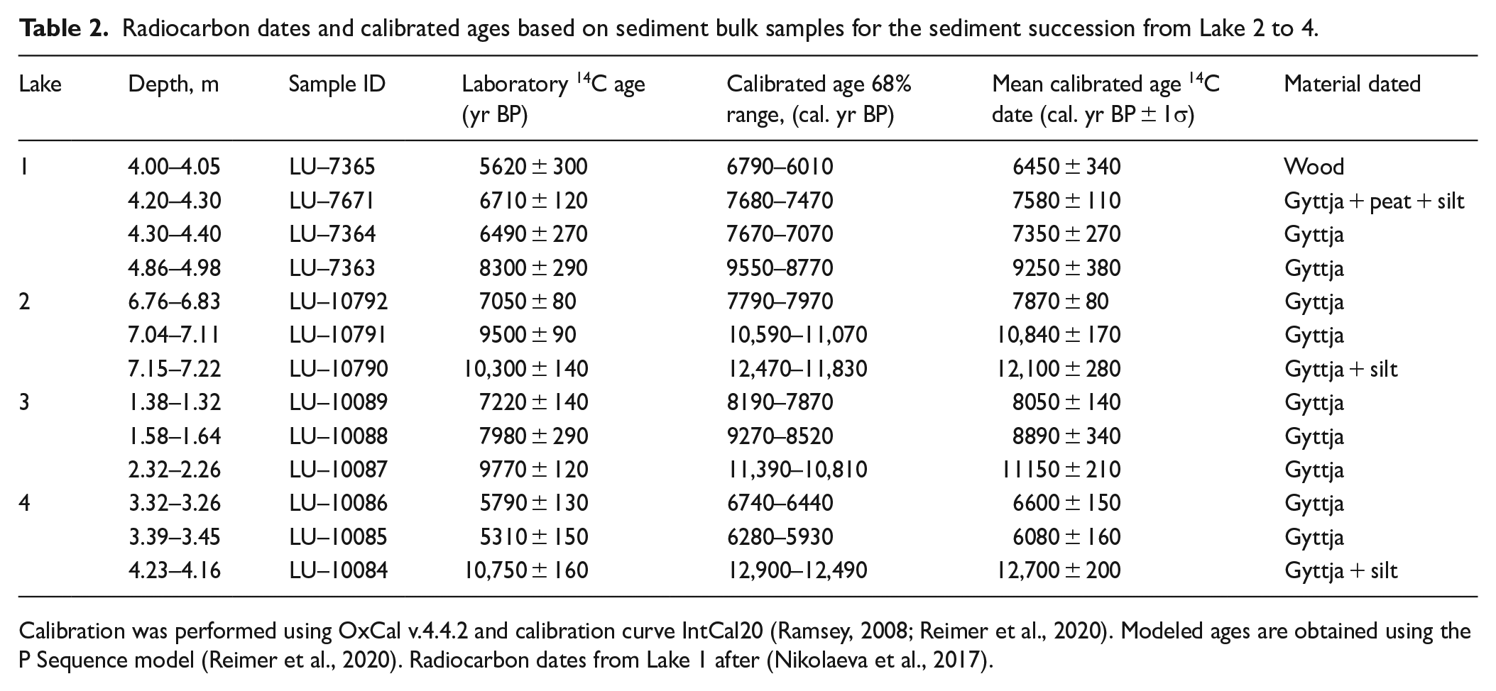
Calibration was performed using OxCal v.4.4.2 and calibration curve IntCal20 (Ramsey, 2008; Reimer et al., 2020). Modeled ages are obtained using the P Sequence model (Reimer et al., 2020). Radiocarbon dates from Lake 1 after (Nikolaeva et al., 2017).
According to the lithological and stratigraphical analysis the accumulation of sediments in the studied lakes began the end of the Younger Dryas and beginning of the Preboreal (12,700 ± 200–11,150 ±210 cal. BP) (Table 2). Since that time the western shore territory of Lake Babinskaya Imandra was already cleared of ice (see Chapter 2). The lakes began accumulating sands and silts of a periglacial lake and in the Preboreal and Boreal they accumulated organogenic sediments of a modern fresh-water lake, that is, gyttja.
There are no disturbances or deformations at the top and bottom of the cores (Figure 5), which indicates a relatively stable depositional environment. In the Middle Holocene there was a disruption of normal sedimentation, as evidenced by the breccia horizon in lake cores (Figures 4 and 5). The BL thickness and lithology vary depending on geometry of each lake and the local environment. The breccia texture is expressed more explicitly in cores from lakes 1 and 3. These are angular isolated fragments of polychromatic gyttja of a size up to 2.5 cm × 3.5 cm, fragments of silt, gravel, broken wood, and abundant vegetative detritus, often with a peat admixture.
The radiocarbon dates indicate the synchroneity of the BL accumulation (6400–6100 cal. yr BP) in lakes 1 and 4 (Table 2). A gyttja sample from non-damaged layer underlying the BL in Lake 1 was dated 7350 ± 270 cal. yr BP, and a wood fragment from the upper part of the BL was dated 6450 ± 340 cal. yr BP. The age of the BL formation in Lake 4 is in 6600 ± 150–6080 ±160 cal. yr BP range. We expected to obtain the similar age from Lake 3. However, the samples indicated an interval between 8050 ± 140 and 8890 ± 340 cal. yr BP which differs from the ages obtained from Lakes 1 and 4 (Table 2). This disagreement can be associated with either blurring of the BL boundaries that probably led to the miscalculation, or another more ancient event.
Detailed sedimentological core analysis correlates well with the GPR data: Two sedimentary strata (mineral and organogenic) are well distinguished, and there is an anomalous breccia horizon (BL) enclosed in gyttja (see Figures 3–5). In addition, GPR data on the lacustrine sediments revealed vertical displacements of glacio-fluvial deposits and various landslides. The intrusion of eroded sands into gyttja allows us to consider them as criteria for additional external (seismotectonic?) impacts that occurred during the accumulation of gyttja, that is, in the Holocene. Thus, both lithological and geophysical data definitely indicate a clear disturbance in the sedimentation and mass movement of lacustrine deposits.
Conceptual model of mass movement in bottom sediments of lakes
A mixture of fragments of sand, silt, peat and wood embedded in the organogenic matrix in lake cores testify to catastrophic mass movement and local landslides. The following conceptual model of their formation can be proposed (Figure 6).
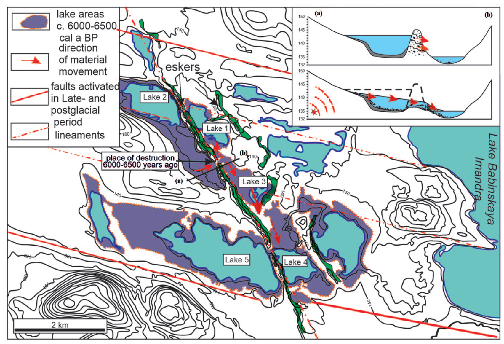
The scenario chart illustrating the trigger mechanism that induces lake disturbance formation. The inset shows a–b profile.
Accumulation of BL layers in the studied lakes could be associated with the catastrophic water breakthrough of the Lake 2 across the esker ridge. It should be noted that all the studied lakes are located along the esker ridges 5 km long that is oriented NW to SE (Figure 2). According to the paleogeographical reconstructions (Armand and Samsonova, 1969; Korsakova et al., 2020; Nikolaeva et al., 2015) the Lake 2 was part of a large paleo-reservoir that occupied a bigger area ca. 6000–6500 years ago than at present. Lake elevations disconnected from the Imandra basin during the period of glacioisostatic uplift of the territory was 4–5 m higher in the Middle Holocene than in present times. Lake 2 was located approximately at the level of 141–143 m a.s.l., and esker ridge at the level of 145–145 m a.s.l. (see Figure 6, inset). As a result of the breaching of esker ridge, that bounded the paleolake two from the east, water was drained from this basin. Part of the sediments was eroded, including the underwater slopes of the basin and the lake margins. Lacustrine sediments were carried by fan-shaped water streams downward the slope eroding the local environment. The direction of these “mud flows” was determined by the topography of the area: they moved from NW to SE a narrow zone between the two esker ridges. “Mud flows” sediments accumulated in lakes 1, 3 and 4 as BL layers. The source of transported material was lacustrine gyttja, mineral sediments from the shores (mainly sands and pebbles), and vegetation. In support of this model, we have noticed that the BL lithology changes with distance from the breaching point (Figure 6). Lakes 1 and 2 contain the BL of 68 cm thick which encompasses polychromatic gyttja with sand interlayers. On the contrary the cross-section of Lake 4, which is the farthest from the breaching point, represents the BL containing only a mixture of gyttja, silt, and sand without breccias and debris.
The observed mass movements in lake sediments are interpreted as potential consequences of the earthquake shaking in the Imandra neotectonic depression.
Discussion
The mixing of fragments of sand, gyttja, wood and peat in the BL horizon, enclosed in a homogeneous massive gyttja from above and below (Figures 3 and 4), happened in the result of an extremely high-energy and instantaneous catastrophic event. Considering that the BL are characterized by large fragments of various rocks (3–5 cm), we consider it unlikely that they are a product of current-driven unequal loading or biological and chemical agents in this type of small lacustrine setting. Fast spontaneous sediment accumulation in lakes, as well as their synchronous formation, testify in favor of strong shaking, which was the trigger for the catastrophic outburst of the lake water basin. Disturbances preserved in lake sequences, presence of traces of strong prehistoric earthquakes in the Imandra neotectonic depression, are interpreted as potential consequences of the earthquake shaking.
Criteria for seismogenic disturbances
The question of how seismogenic disturbances in sediments can be recognized on the basis of specific criteria has been discussed extensively in the literature (Moretti and van Loon, 2014; Owen and Moretti, 2011; Sammartini et al., 2021). The following main criteria to recognize seismogenic disturbances summarizing some studies on this same topic were proposed: (1) type of disturbances in lacustrine; (2) sediments simultaneous formation in more than three lakes; (3) lithological distribution features within the boundaries of one lake to avoid an artifact must be taken into account; (4) lack of indications for any other causal mechanisms; (5) stratigraphic position in between undisturbed layers; (6) location of sedimentary basins within the areas of tectonic or seismic activity; (7) substantial lateral extent. We will consider the breccia layers of lacustrine sediments in the following sub-sections in the context of the criteria above mentioned.
Substantial lateral extent is the best criterion for the seismic origin of the disturbances in lacustrine basins (Owen and Moretti, 2011). Figure 2 shows that the BL horizons are revealed not in a single lake, but in several lakes spaced more than 5 km apart from each other. This completely excludes the artifact. The anomalous layers (BL) are underlane and overlane by non-deformed sediments as shown in Figure 5. As a result, the studied lake deformations satisfy the 1–5 criteria. In addition, detailed sedimentological core analysis correlates well with the GPR data (Figure 3). The intrusion of eroded sands into gyttja allows us to consider them as criteria seismotectonic impacts that occurred during the accumulation of gyttja in the Holocene.
The studied reservoirs are located directly within the sources of large paleoearthquakes confined to active fault zones (Nikolaeva et al., 2018). Therefore, their bottom sediments are expected to confirm major earthquake events. Traces of past strong earthquakes (rock slides, split of the upper parts of watersheds, fractures) are revealed on the western flank of the Lake Imandra depression. The fault activity was manifested as reverse-fault–shear processes along the uplifted vertical western wall of the fault (Figure 1, Chuna fault), which occurred in several stages throughout the Late Glacial and postglacial periods: ~13.5 ka, 10.3–7.1 ka, ~2.5 ka. Another normal fault of the northeastern extension, more than 10 km long, was identified on the western flank of the Babinskaja Imandra, SW of the Upoloksha railway station (Figure 7). Segments of the sublatitudinal fault that bound Lake Babinskaya Imandra from the south were also reactivated. The horizons reflecting the Late Pleistocene and Holocene seismic events are recorded in the loose sediments of the Imandra Lake terraces (Nikolaeva, 2022). These events led to the occurrence of secondary deformations (phenomena of liquefaction, cracks, and dykes) in the sandy-silty sediments. The amplitudes of known fault displacements in loose sediments range from 0.2–0.5 to 1.8–2 m. Weak modern earthquakes also indicate the seismic activity of the territory (Godzikovskaya et al., 2010). As a result, the studied deformations in lakes satisfy several criteria known both from the literature data and from field observations.
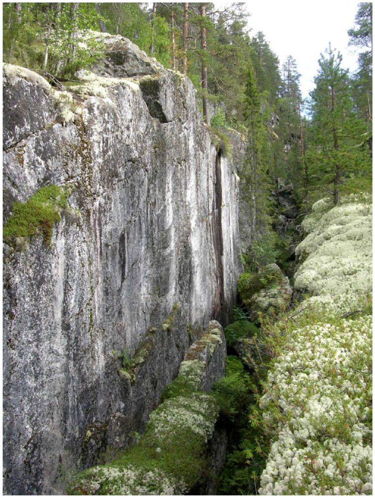
NE trending seismic dislocations in gneiss-granite on the western flank of the Babinskaja Imandra.
The earthquake, which presumably was a trigger for the formation of the deformations, was generated by the activation of ancient fault zone of the NE strike or by the activation of sublatitudinal faults bounded of Babinskaya Imandra depression. The earthquake epicenter could be located either in the tectonic zone under the bottom of Lake Imandra or in the Khibiny center, one of the most seismically active nodes of the Kola region (Godzikovskaya et al., 2010).
Age
The radiocarbon dates indicate the synchroneity of the BL accumulation in lakes 1 and 4 (Table 2), which indicates the age of the earthquake around 6400–6100 cal. yr BP. We expected to obtain the similar age from Lake 3. However, the samples indicated an interval between 8050 ± 140 and 8890 ± 340 cal. yr BP which differs from the ages obtained from Lakes 1 and 4 (Table 2). This disagreement can be associated with two aspects: (1) the boundaries of the breccia layer in the Lake 3 are very indefinite, “blurred,” and mixed, that probably led to the miscalculation due to confusing lithology, (2) or another more ancient event. Event 6400–6100 cal. yr BP is more reliable. The reasons for this conclusion are as follows. There is geological evidence of earthquakes with an age of 6000–7000 cal. yr BP in this area. For example, in the Kola region the sediments of Kovdor Lake 50 km to the west of studied area are eroded and have inclusions of “foreign” material, such as pebbles, gravel, and wood remains formed due to seismic shakes (Nikonov, 2007). The event occurred approximately ca. 6500 cal. yr BP. Deformations and lithological unconformities were discovered in the bottom sediments of Lake Tikozero on the southern shore of Lake Ekostrovskaya Imandra 10 km away from the studied lakes within the time span of 6500 and 3500 cal. yr BP (Korsakova et al., 2022). In fact, we interpret that the BL as a consequence of an earthquake happened around 6400–6100 cal. yr BP. However, it should be noted that we cannot completely exclude another event, more ancient.
Intensities and magnitudes
Noteworthy, the present day archive of seismites of the Eastern Fennoscandia is far from completion. Currently we do not have a fairly representative database on the same-aged paleoseismic deformations and cannot estimate the propagation area of seismic shakes. Thus, the so called “Imandra event” should rather be considered as a local manifestation of seismicity. We can make only a rough estimation of intensity and extent area of seismic shakings.
Liquefaction and deformation in loose sediments usually happen when Mw ⩾ 5 (Ambraseys, 1988; Obermeier et al., 2005). Nevertheless, some seismically induced deformations are known to occur in the result of the earthquakes with the shaking intensity of VI–VII and Mw = 3 (in case the earthquake is not a deep one) (Keefer, 1984; McCalpin, 2009). Regarding the small depth of hypocenters of modern earthquakes in the Eastern Fennoscandia (5–20 km) as well as the intensity on the INQUA scale (Michetti et al., 2007) we may assume that the minimum magnitude of the local Lake Imandra Event was about Mw = 4.5–5, and the shaking intensity was about V–VI.
The generalization of paleoseismic data on Finland, Sweden, Norway, and Russia shows that the high-magnitude peak and frequency of the earthquakes took place during deglaciation and the Early Holocene (Kukkonen et al., 2010; Lagerbäck and Sundh, 2008; Stewart et al., 2000). According to Ojala et al. (2019) faults with 1–2 cm shift in sediments of Lake Immeljarvi in Finland are interpreted as the marks of an earthquake of 6700 cal. yr BP, and a landslide in Lake Laukkujarvi happened ca. 7000 cal. yr BP. Based on deformations of clastic-biogenic varves in Lake Nurmijärvi, a relatively high-magnitude seismic event (Mw ≈ 5.1–6.9) occurred in southern Finland 7400 cal. yr BP, which is about 3500 years after the deglaciation of the area (Ojala et al., 2018). Scientists in the Eastern Norway (Mangerud et al., 2018) made a conclusion that the diamicton (landslide) fragments in Homme region were produced by an earthquake of the age of 6400 cal. yr BP. A number of events have been documented in Sweden. Among them are a regional earthquake with Мw = 6–7 happened in Billingen region ca. 5700 cal. yr BP, a local earthquake with Мw > 8 in Hudiksval region ca. 6100 cal. yr. BP, and regional earthquake in Umea area ca. 6680 cal. yr. BP (Mörner, 2005).
Thus, our data and the studies in recent decades have shown that the eastern Fennoscandian shield was struck by strong earthquakes not only in the Late Glacial and Early Holocene periods, but also at a later time. At the time of deglaciation up to Middle Holocene time, Fennoscandia constituted a high to super-high seismic region in magnitudes as well as in frequency (Mörner, 2005). The seismotectonic manifestations in the Middle Holocene were likely to have been less strong than during the deglaciation. Fault movement and seismicity were caused by a combination of tectonic and glacially induced isostatic stresses, with the magnitude of the glacioisostatic effect decreasing.
Conclusions
The observations from the present study extend the paleoseismic catalog by identifying new evidence of Mid-Holocene earthquake in northeastern Fennoscandia. The paper shows that an earthquake that caused mass movement of sediments and landslides left its traces in sedimentary basins of four lakes situated on the western flank of the Lake Imandra Neotectonic Depression. The lacustrine cores revealed a horizon indicating this event. The horizon contains sedimentary breccia mixed with sand, silt, and peat included in a homogenous gyttja. The simultaneous formation of anomalous sediments in several lakes and their lithology along with the documented Holocene tectonic activity of the Lake Imandra depression all substantiate the idea of a seismic trigger. In accordance with the radiocarbon dating a seismic event with Мw ≈ 4.5–5 and I0 = V–VI took place in the Atlantic Period of the Holocene 6400–6100 cal. yr BP.
Our studies show that although this area is not seismically active today, some of the main fault zones to have experienced short periods of reactivation also in the postglacial time, when glacioisostatic rebound after the ice retreat was already very low. The data obtained form the basis for predicting the state of the natural environment, the frequency of natural disasters and assessing natural risk.
Footnotes
Acknowledgements
We are grateful to our colleagues from the Geological Institute of the Kola Science Center RAS for their help during the fieldwork. We also grateful to the reviewers for their carefull reading and comments, which greatly improved the manuscript.
Funding
The author(s) disclosed receipt of the following financial support for the research, authorship, and/or publication of this article: The research was supported by the Ministry of Science and Higher Education of the Russian Federation, projects AAAA-A19-119100290145-3; FMEZ-2022-0027.
