
Abstract
Endorheic river basins and their terminal lakes are highly sensitive to climate change and human activities. Based on chemical and pollen indicators, lake level, and erosion/accumulation rates of rivers, we explore the phasing of the evolution of the river system in the Hexi Corridor during the Holocene. The results suggest that climate change dominated the evolution of the river system during the early-Mid-Holocene. Entering the historical period, humans began to have an impact on runoff, water resources, and lake evolution, and since 1000 BP, anthropogenic perturbations recorded by regional proxies increased and humans dominated the migrations of river . In addition, we discuss the widespread erosion of rivers in the global endorheic zone and the impact of human activities in this context and found the timing of human influence on river evolution is not the same in different regions.
Keywords
Introduction
Rivers are notoriously effective at reworking terrace sequences, eroding, and redepositing their alluvium (Grant, 1985; Lespez et al., 2011; Nanson and Huang, 2018; Phillips and Jerolmack, 2016). An endorheic basin is one in which the river system within the domain is not connected to any other external river body such as a river or ocean but rather brings the river together in the form of a lake or marsh (Meybeck, 2003; Vii, 2007; Yapiyev et al., 2017). As a river flows from the mountains to the lake, the amount of erosion and deposition changes. This changes what the river looks like from its source to its ends. In its upper-middle course, a river erodes vertically creating steep valleys and terraces, and erodes laterally causing the river to start meandering (Faisal and Hayakawa, 2022). By the time the river reaches its lower course, the eroded material (sediment) carried by the river begins to be deposited in the terminal lakes. These processes create variation in geomorphology across the basin and in such cases fluvial geomorphic features are informative for exploring the evolution of river systems, especially in the Holocene.
Climate change is thought to have been the cause of widespread episodes of river erosion during the Holocene (Brakenridge, 1980). It affects the erosive capacity of the river through intermediaries such as (1) the base level, (2) a change in precipitation and discharge, (3) the river’s sediment load, and (4) the vegetation cover in the catchment (Giguet-Covex et al., 2011). A crucial question is whether the river dynamics during the Holocene have been sensitive to millennial and centennial climate variability or whether they have been conditioned by other factors’ influence (Li et al., 2020a; Tucker and Slingerland, 1997). Most of the world’s classic civilization centers such as China, Mesopotamia, are close to the modern active river branches, or former river branches of the Late-Holocene (Lu et al., 2022). Long-sustained coeval geomorphological and human activity has taken place, creating spatially extensive and continuous fluvial archives (Piccarreta et al., 2011; Stinchcomb, 2012; Wohl, 2006). In these areas rivers continuously changed their course and networks due to avulsion, creating new and abandoning older channels. In addition in these areas cultures changed, and distinct cultural periods emerged and succeeded (Yang et al., 2020). Even though land use and climate are not independent, they change at different spatial and temporal scales, exerting a complex driving pattern on fluvial systems (Yu et al., 2016). When addressing long-term interactions between past climate, human activities, and geomorphological processes, it is fundamental to fully understand erosion and sedimentation’s spatial and temporal dynamics.
A “whole catchment” tactic is essential if we are to better understand our fluvial systems more fully (Macklin and Lewin, 2008). The study of the impacts of human activities and climate change on the evolution of river systems requires an interdisciplinary approach integrating geological and archeological datasets derived from fluvial archives to elucidate geomorphic processes between erosion-prone rivers’ upper course and sediment-dominated rivers’ lower course (Mather et al., 2017). Here, the development of ancient civilizations and the prosperity of the Silk Road coincide with changes in the flow, channel dimensions, and caudal lakes of the major rivers of the Hexi Corridor over the past 10,000 years. In this context, the work of this paper concentrates on reviewing previous geomorphological studies in the Hexi Corridor. In addition, this paper attempts to review some major aspects of the Shiyang-Shule-Heihhe river system and to assess the variability of changes in the downstream tailrace taking into account the regional climatic similarities in the upper reaches. This paper also discusses aspects of human activities that have influenced regional river changes over the last 2000 years, which can help us to maximize the discussion of factors influencing the evolution of global instream flow.
Material and methods
Setting
The Hexi Corridor lies between 36°N and 41°N and 93°E and 104°E. Sandwiched between the Qilian Mountains and a series of deserts on the northern border of the Qinghai-Tibet Plateau, this corridor is the most convenient route between northern China and Central Asia. It is located at the boundary between the typical arid to semi-arid region, the westerly wind region, and the East Asian summer monsoon region (Figure 1) (Zhang et al., 2015). The Shiyang River, Heihe River, and Shule River originate in the Qilian Mountains, and each sink into a catchment basin in the lower course of them, forming a complete endorheic basin (or convert to groundwater). After the river flows out of the mountain, it will diffuse during the flood period and form a vast alluvial fan. When the flow is stable there is a fixed channel, which is usually on the alluvial fan, but at the same time, there are diversions of the river due to various reasons. In the middle-lower course, the location and volume of channel and terminal lakes also change continuously in response to changes in the upper course. The runoff of the three inland rivers is the main source of water for grasslands and farms in the Hexi Corridor and as such, it has historically hosted both farming and nomadic civilizations. The corridor represents the easiest passage between northern China and Central Asia, and therefore, formed the basis for the famous Silk Road, which has been an important route for traders and the military for almost a millenium.
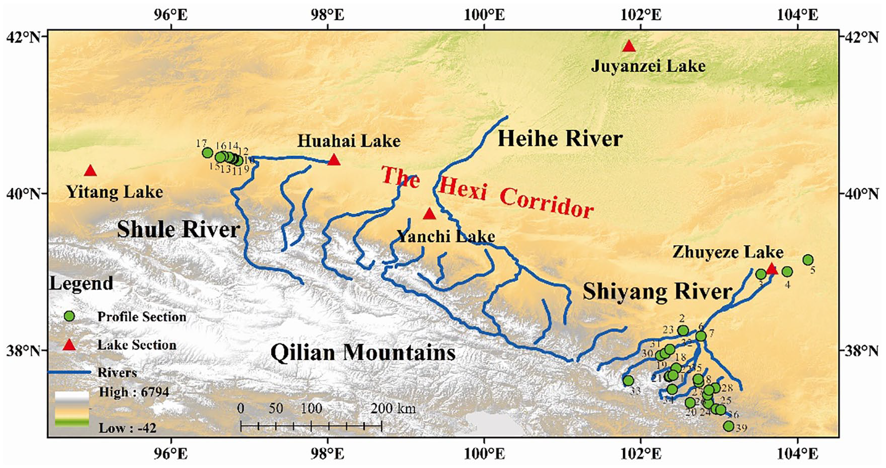
Study region and sampling site. All data are taken from published papers, and these sediment samples were collected from outcrop profiles and excavated lake profiles of the region. The sampling strategy can be found in the corresponding references (Supplemental Table 1–2, Supplemental Figure 1). 1: HX, 2: ZJDZ, 3: XQ, 4: SKJ, 5: JTL, 6: JDT, 7: HSH, 8: XH, 9: SANDG, 10: SIDG, 11: WDG, 12: LDG, 13: QDG, 14: BDG, 15: JDG, 16: SHIDG, 17: AX, 18: Xiazhuangzi, 19: Lijiatai, 20: Gulangxian, 21: Niujuangoutai, 22: Qiaoerlun, 23: Shagouhe, 24: Niufangzicao, 25: Sigouzhaizitan, 26: Xiwan, 27: Sigouzhaizi, 28: Qingdabantan, 29: Yezhigou, 30: Shanggoudadui, 31: Kangningqiao, 32: Donghucun, 33: Ningchanhulinzhan, 34: Shuixiakou, 35: Huangyanghequshouxia, 36: Xitaozigou.
River erosion/deposition and ancient lake extent
To widen our knowledge of the Holocene fluvial in the Hexi Corridor, based on previous field surveys, river downcutting, and accretion rates have been calculated to understand the state of water and sand transport in rivers. Since this comes from our previous work, the rate calculation is described in detail in the references (Li et al., 2015; Wang et al., 2016). Shore chronology results for the palaeolake Zhuyeze Lake and Juyanze Lake (Supplemental Table 4) are obtained from the published literature (Jin et al., 2015; Long et al., 2012).
Proxies and lithology
Climate change in the Hexi Corridor over the past 10,000 years is reconstructed using representative high-resolution paleoclimate proxies, including ice cores and lake sediments (Figure 1). In addition, we collected chronological, literature, and paleoenvironmental proxy data from the published literature in the study area that has a continuous chronological sequence and no depositional interruptions (Supplemental Table 2). The dating data are dominated by 14C dating and OSL dating sequences, and data that are not corrected for 14C dating are processed using Calib 8.1.
Social history data
For the effects of climate change on human societies, a large body of literature and local chronicles are surveyed to obtain the most reliable information on changes in population size over time (Cheng, 2007; Jiang, 2008; Zhang and Qi, 1998). As the data relating to the various factors analyzed are discontinuous, it is not possible to obtain complete data from 2 AD to 1998 AD. Instead, the available data are summarized to provide an average of 40 cycles (every 50 years). In the absence of data for 50 years, we used interpolation between adjacent periods to estimate the missing data. Ancient site data from Gao and Li (2023).
Result
Evolution of river systems
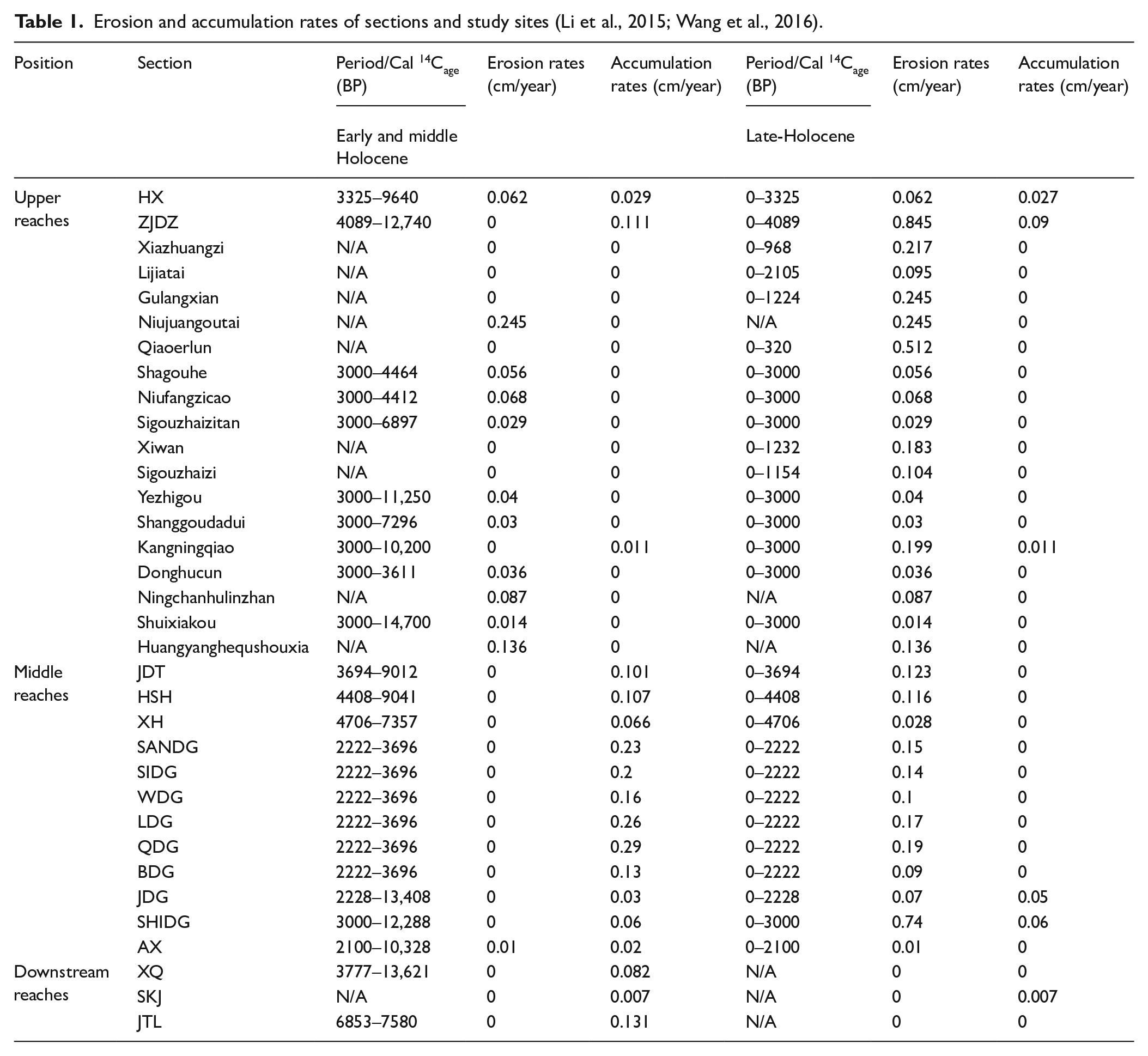
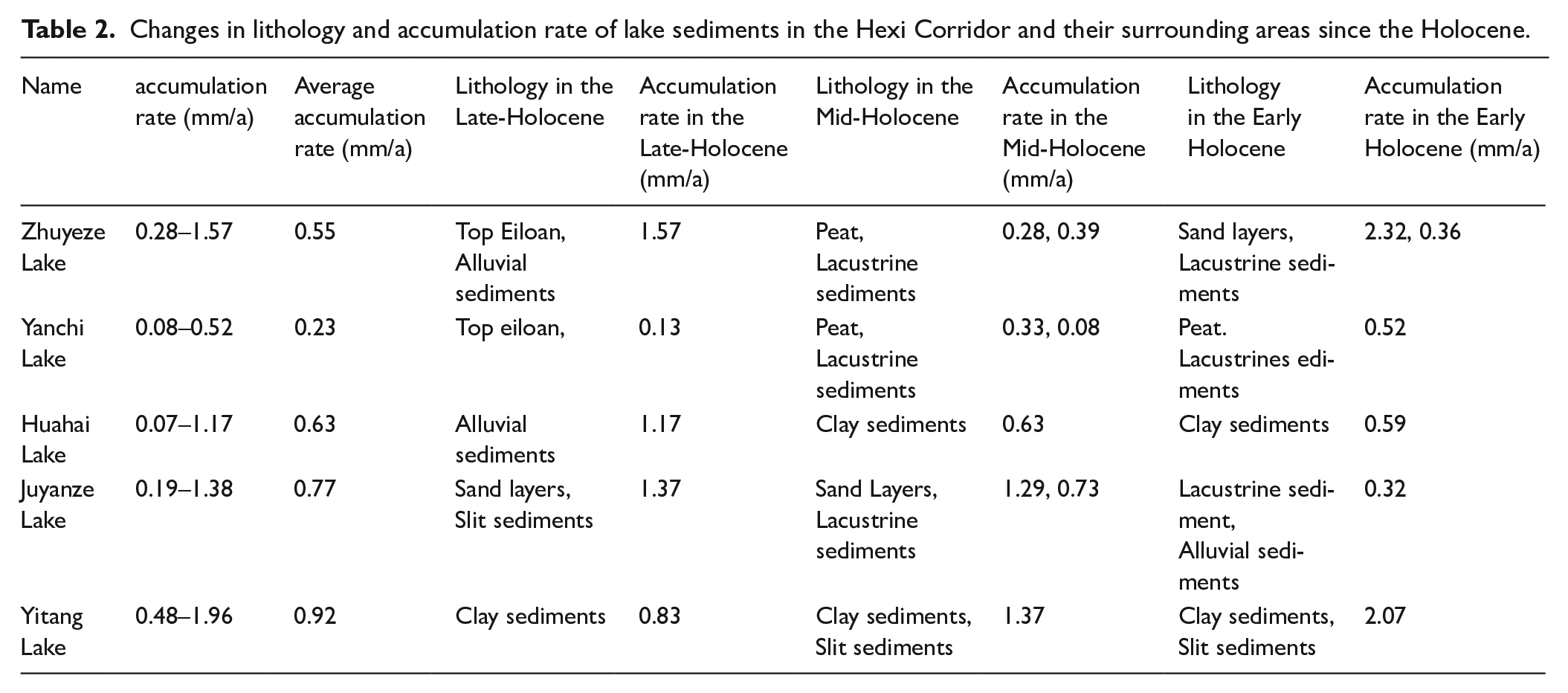
During the Holocene, there was widespread downcutting of rivers in the Hexi Corridor, creating river terraces (Supplemental Table 3). The formation of terraces generates large quantities of sediment that are carried by rivers to accumulate in the middle and downstream reaches of the river, where they form terminal lakes and lake sediments in the area. In the Early to Middle Holocene, the erosion rate was low in the upper reaches of the river in the Hexi Corridor, but the accumulation rate was high in the middle and downstream reaches (Table 1). Zhuyeze Lake reached a high lake level in the Shiyang River, and alluvial profiles on the Shule River flood fan show high TOC (Total Organic Carbon) and pollen (Figure 2e, f and j). Since the Late-Holocene, lower deposition rates and changes in lake sediment lithology and deposition rates have occurred in the downstream area of the Hexi Corridor (Tables 1 and 2). Zhuyeze Lake began to retreat during this period, with a decrease in TOC and an increase in Chenopodiaceae pollen content (Figure 2g, h and j). In contrast, Juyanze Lake reached a high lake level and high A/C and TOC (Figure 2c, d and i). JDG showed a gradual rise in TOC and pollen in the Shule River (Figure 2e and f).
Erosion and accumulation rates of sections and study sites (Li et al., 2015; Wang et al., 2016).
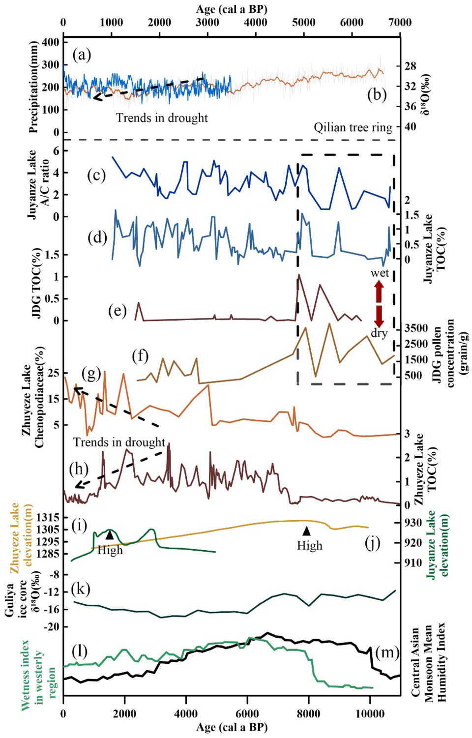
Proxy records of Holocene climate change from the Hexi corridor. (a) The reconstructed annual precipitation by tree-ring record from Qilian Mountains (Yang et al., 2014). (b) The gray line is δ18O of the DLH tree-ring (Yang et al., 2021). The orange line is the mean fitting curve calculated.(c)-(d) A/C and TOC of G36 from Juyanze Lake (Hartmann and Wünnemann, 2009; Herzschuh et al., 2004). (e)-(f) TOC and pollen concentration of JDG (Mao, 2008). (g) Chenopodiaceae percentage of QTH02 (Li et al., 2009). (h) TOC of QTH01 from Zhuyeze Lake (Li et al., 2012). (i) Changes in lake levels in the Zhuyeze Lake (Long et al., 2012). (j) Changes in lake levels in the Juyanze Lake (Jin et al., 2015). (k) δ18O of Guliya ice core (Thompson et al., 1997). (l) Wetness index in westerly region (Chen et al., 2008). (m) Central Asian Monsoon Mean Humidity Index (Herzschuh et al., 2006).
Changes in lithology and accumulation rate of lake sediments in the Hexi Corridor and their surrounding areas since the Holocene.
Human activity
During the Neolithic period, ancient sites were mainly located in the southeastern part of the Hexi Corridor, with a few in the northwestern part, and they were all located at high altitudes (Figure 3a). During the Bronze Age, ancient sites were widely distributed throughout the region, and the average altitude has decreased compared to the previous period (Figure 3b). The Hexi Corridor was formally incorporated into the political system of the Central Plains Dynasty (88 BC). During the Han Dynasty, ancient cities were scattered around the Han Great Wall, and during the Tang Dynasty, they were reduced and mainly distributed in the east of the Hexi Corridor, but in the Qing Dynasty, the number of ancient cities proliferated and were distributed along the outer side of the Ming Great Wall (Figure 3c). Regarding the spatial distribution of oases, oases were scattered in the lower reaches of the rivers during the Han Dynasty, During the Tang Dynasty, the area of oases shrank (Figure 3d and e). The peak of the oasis area was reached in the Qing Dynasty, and the oases in this period were mainly concentrated in the plain area in the middle reaches of the river (Figure 3f).
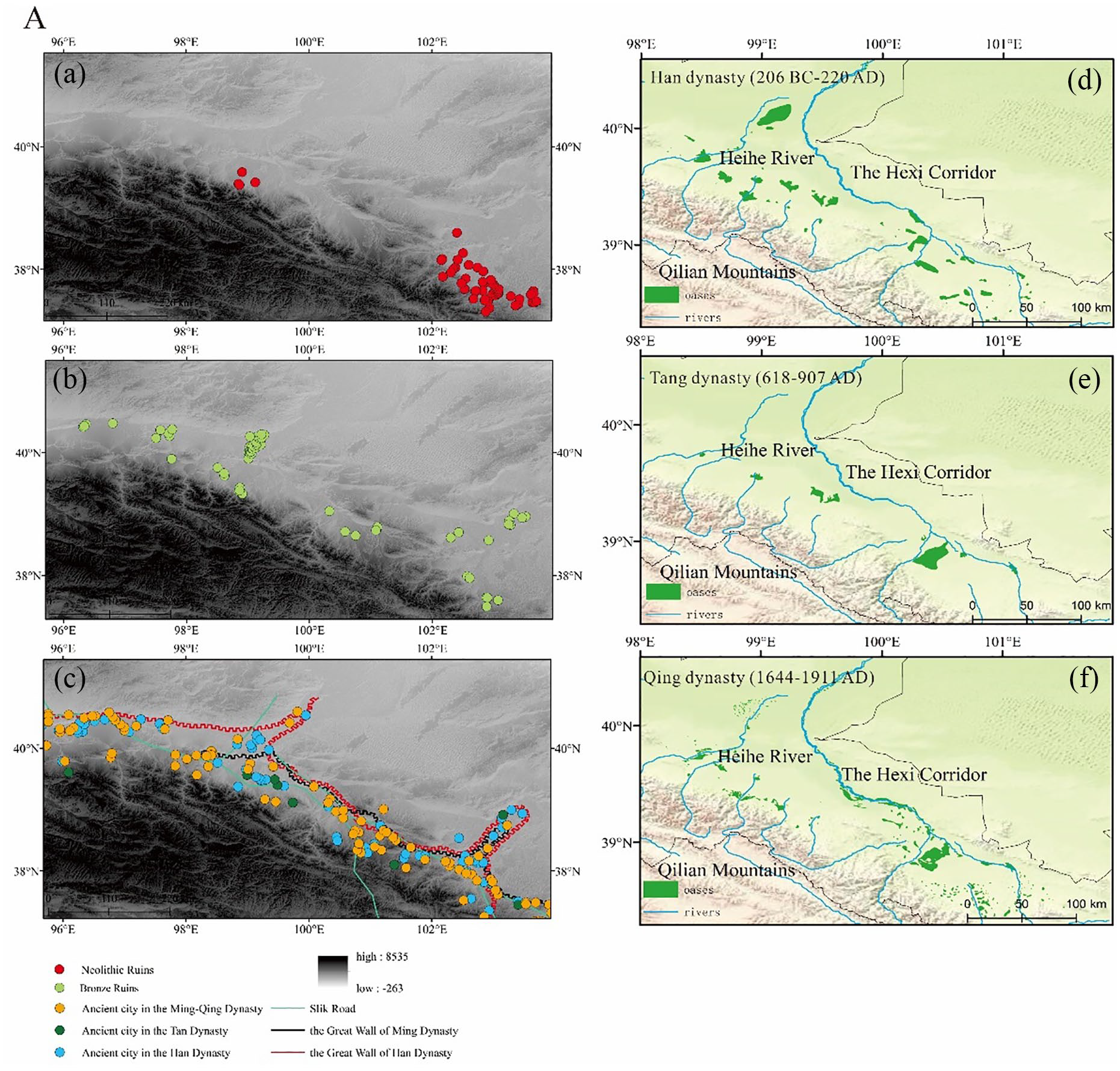
Ancient site in the Hexi Corridor between Neolithic to Historic Period (a–c) and the extent of the Heihe Oasis in the historical period (d–f).
Discussion
River evolution in response to climate change in the Hexi Corridor during the Holocene
In the endorheic basin, sediments are usually subjected to erosion in areas of high relief, such as upper river valleys, and carried by rivers to accumulate in the middle and lower reaches (Hu et al., 2006). Tectonic activity is usually considered the dominant factor in the geomorphological evolution process on long time scales; while on shorter time scales (Millennial or centennial-scale), climate change is also one of the important controlling conditions for geomorphological evolution . Climate change affects river runoff and sediment loads through changes in precipitation, evaporation, effective humidity, and vegetation cover, thereby controlling the processes of river erosion and accumulation (Gao et al., 2017). Records from the Greenland Ice Core and the Cariaco Basin indicate an increase in temperature in the North Atlantic region since the last deglacial (Liu et al., 2007; Shen et al., 2005). According to the Donggot Cave, Huguangyan Maar Lake, and Qinghai Lake records, the intensity of the Asian summer winds gradually increased from the LGM (Late Glacial Maximum) and lasted until the Middle Holocene period (Dykoski et al., 2005; Yancheva et al., 2007). In contrast, there is an out-of-phase of the effective humidity change between the westerly and monsoon regimes, based on the Central Asian arid zone lake records and the Holocene climate simulations (Chen et al., 2008; Li et al., 2020b). The Hexi Corridor is the northwestern edge of the modern Asian summer winds, and the region is also influenced by the westerlies, and water vapor transport is also mainly derived from them (Li et al., 2020).
In the Shiyang River basin, the strong Asian monsoon in the Early and Middle Holocene resulted in high river flow and strong hydrodynamic conditions, which led to enhanced lateral erosion but reduced vertical erosion while allowing the river to transport large amounts of sediment (Figure 2m). A large amount of sediments accumulated in the middle and lower reaches and formed the stable terminal lake Zhuyeze Lake, which had a high lake level and was enriched with elements and pollen in lake sediments during this period (Figure 2h and j). In the Shule River basin, the rivers carried sediments that accumulated in the middle reaches of the rivers and formed temporary rivers and lakes on the left side of the floodplain fan (Mao, 2008). As the climate warms and becomes wetter, rainfall in the basin increases, plant cover rises, the submerged level of the flood fan rises, and the groundwater overflow zone moves toward the middle of the flood fan (Mao, 2008). The weakening of the monsoon in the Late-Holocene resulted in droughts and reduced river flows, which enhanced vertical downcutting of rivers but reduced sediment transport capacity (Figure 2a, b and m). From about 3000 BP, the accumulation rate of the sediments, elements, and spores in the lower reaches decreased, and the terminal lake gradually shrunk in the Shiyang River Basin (Figure 2h and j). Aridification in the Shule River basin began as late as about 2000 BP, and the erosion rate was low (Table 1) ( Li et al., 2015; Wang et al., 2016). Based on the expansion-retreat study of Yanchi Lake in the middle part of the Hexi Corridor during the Holocene, Li et al found the Asian summer wind boundary may have oscillated in the Hexi Corridor on the millennial scale (Li et al., 2013). The main influence of the Late-Holocene Asian summer winds retreated to the eastern section of the Hexi Corridor, and the western section was mainly controlled by the westerlies, so that the Early and Middle Holocene Shule River was controlled by the monsoon, and the Late-Holocene Shule River Basin was mainly controlled by the wetter westerlies.
In the middle and Late-Holocene, the lake level in the Juyanze Lake was higher, and no stable lakeshore embankment was found after 1600 BP (Wei, 2019). Based on the lake sediments and loess-palaeosoil records, combined with modeling results, it is shown that the westerlies-influenced area was arid in the Early Holocene, with a wetting trend in the Middle and Late-Holocene (Chen et al., 2016; Wang et al., 2013; Zhang et al., 2017a). On the one hand, winter solar radiation in the Northern Hemisphere gradually increased during the Late-Holocene (Wang and Feng, 2013), which led to an increase in winter temperatures in the North Atlantic (Davis et al., 2003) and allowed more water vapor to enter the westerlies system, which brought precipitation to the downwind inland areas (Wang et al., 2013). Moreover, warmer continental temperatures in winter create more cyclonic activity inland, which enhances westerly flow disturbances and increases convective precipitation (Chen et al., 2008). On the other hand, the intensity of summer solar radiation in the Northern Hemisphere tended to decrease during the Middle and Late-Holocene (Berger and Loutre, 1991; Wang et al., 2013), and the difference between winter and summer solar radiation became smaller, which led to an increase in precipitation and a decrease in evaporation in the Juyanze Lake region, increasing effective humidity. Thus, the middle to Late-Holocene was a wetter period in the Juyanze Lake, with high lake levels (Figure 2i and l).
Human-river relationships in the Late-Holocene of the Hexi Corridor
The mountains, alluvial fans, rivers, and terminal lakes constitute a nearly ideal environment for flood agriculture, and the spring and summer floods produced by melting glaciers and snow provide a reliable source of water for irrigation. Local precipitation and glacial meltwater vary with climate change, thus affecting the flow in the Hexi Corridor, which has a significant impact on the water supply of human settlements in the Hexi Corridor. We have mapped the impact of human activities on rivers at different times in the Hexi Corridor (Figure 4). Since the Late-Holocene, human activities in the Hexi Corridor have shown complex features and stage changes (Li, 2009, 2011). After entering the historical period, with the increase of population and structural changes in the Hexi Corridor, its mode of production experienced several iterations in different dynasties, with a progressively strong influence on rivers.
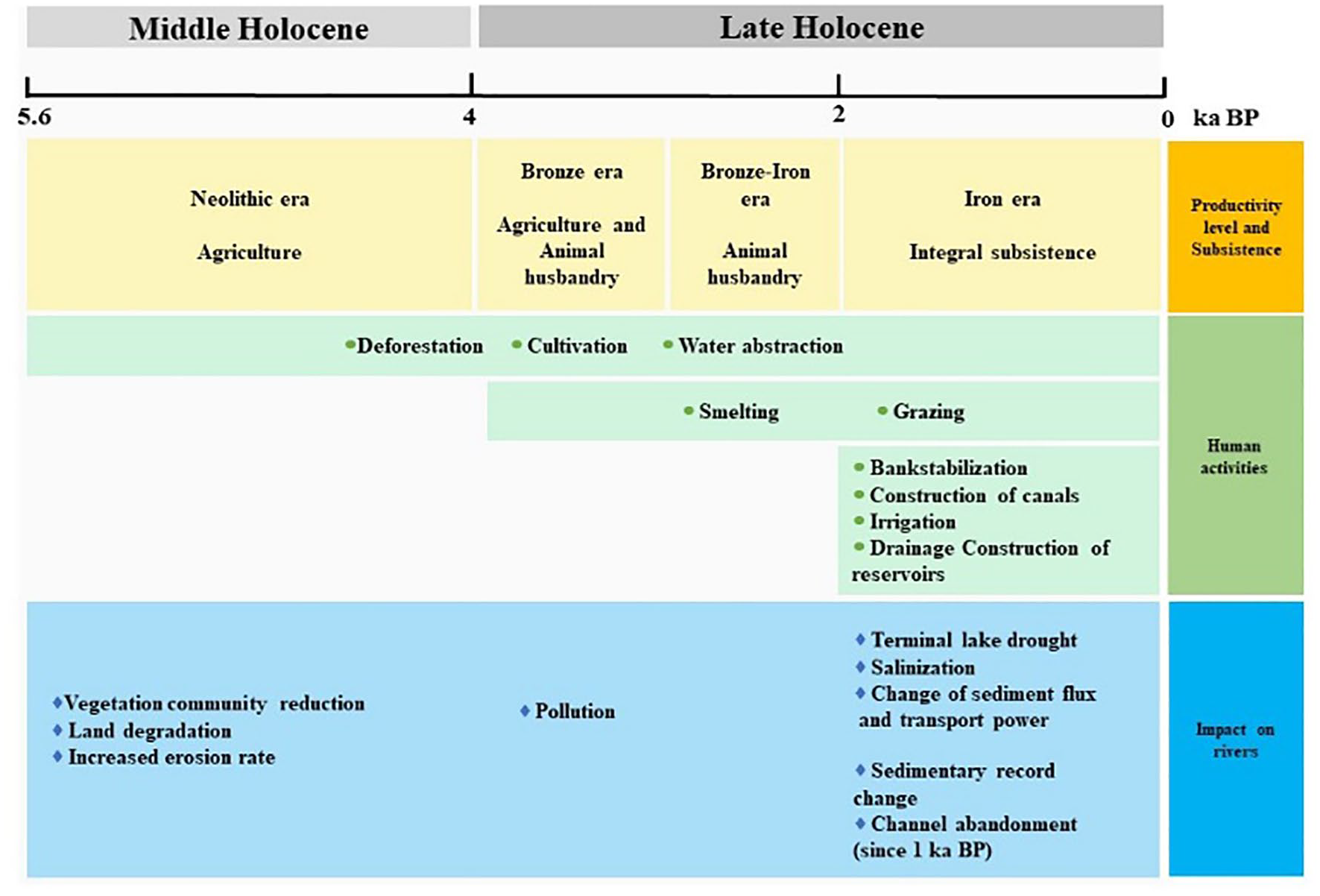
The impact of human activities on rivers at different times in the Hexi Corridor.
The alluvial fan situated before the mountains in the Hexi Corridor displays substantial loess accumulation, accompanied by deep undercutting of the river valley. Settling in the alluvial plateau provides a strategic escape from flooding, offering ample available water resources. Downstream of the alluvial fan, the river channel undergoes intensive scouring, resulting in significant soil and water erosion and the formation of the Gobi Beach. Progressing further downstream, the river channel tends to stabilize, giving rise to the oasis in the river valley, and eventually culminating in the formation of the caudal lake area in the lower part of the river. The diverse water conditions in these regions influenced human settlements during that era. In areas surrounding terminal lakes or featuring favorable conditions on the alluvial terrace, human communities engaged in deforestation, initiated crop cultivation, and began smelting activities. This marked the onset of a relatively advanced agricultural economy in these regions. (Dong et al., 2013; Yang et al., 2020). On the edge of the desert, where water is scarce, human beings are mainly engaged in the graze way of life, with few scattered sites (Yang et al., 2020). When the climate becomes cold and dry, river systems shrink and land degradation occurs (Hou et al., 2012; Shen et al., 2005), agricultural culture is completely replaced by animal husbandry culture. During the early Late-Holocene, human production activities can have an impact on the surface environment and rivers, such as vegetation community reduction, land degradation, increased erosion rate, and pollution, but to a small extent (Figure 4) (Ren et al., 2021, 2022; Yang et al., 2017, 2019). Human production activities and settlement reflected the dependence on rivers, and the diversion of rivers and the reduction of water volume affected the livelihoods of humans in the region, thus contributing to the evolution of civilization.
The construction of the Hexi Corridor expanded over the past 2000 years due to bank stabilization, construction of canals, drainage construction of reservoirs and other measures (Wu and Guo, 1996). In a previous study, we used PLR (Piecewise Linear Regression) to analyze the inflection point in the evolution of lakes in the Hexi Corridor, the period when the Han Dynasty began to rule the Hexi Corridor (Li et al., 2023). We analyzed the anthropogenic signals expressed in the sediment proxies of the Hexi Corridor and found that MS (Magnetic Susceptibility) and CaCO3 in the Yanchi Lake and the median grain size of the Zhuyeze Lake show an increasing trend in the Tang and Qing Dynasties, which may be attributed to the reduction of the regional vegetation cover and soil erosion due to the population boom in the Hexi Corridor since there were no sudden change points in temperature and precipitation at this time (Figure 5a–f and i) (Hou et al., 2012; Li et al., 2012; Marcott et al., 2013; Wang et al., 2005; Yu et al., 2006). The TOC of the Zhuyeze Lake during the Tang Dynasties is a sudden increase that may be attributed to the favorable conditions of regional vegetation due to anthropogenic development at that time, while the subsequent decrease is due the rebels and nomadic domination (Figure 5g) (Li et al., 2017). The TOC of Yitang Lake has become less coherent with climate since 3000 BP, possibly related to disturbances from increasing anthropogenic activities in the region (Figure 5h) (Zhao et al., 2015). Reconstructions of human water use and lake water over the past 2000 years also suggest that human water use in the upper and middle reaches alters downstream runoff into the lake, which in turn affects lake evolution (Figure 5j and k) (Lu et al., 2015). Studies on the contribution of human activities to lake changes during the historical period showed that the magnitude of human activities in the lower Shiyang River lakes was 28% throughout the historical period, and as high as 88% since the Qing Dynasty, and the increase in population was the main reason for the rapid shrinkage and even sanding of the lakes in the later period (Figure 5f) (Wang et al., 2009). From the point of view of the process of lake evolution in Northwest China, the rate of drying and shrinking of lakes in the past 2000 years has far exceeded that of the natural period, and the lakes in the Hexi Corridor and its surrounding areas have receded significantly, with the Zhuyeze Lake, Yanchi Lake, Huahai Lake, and Jiayanze Lake drying up rapidly (Table 2)(Wang et al., 2002).
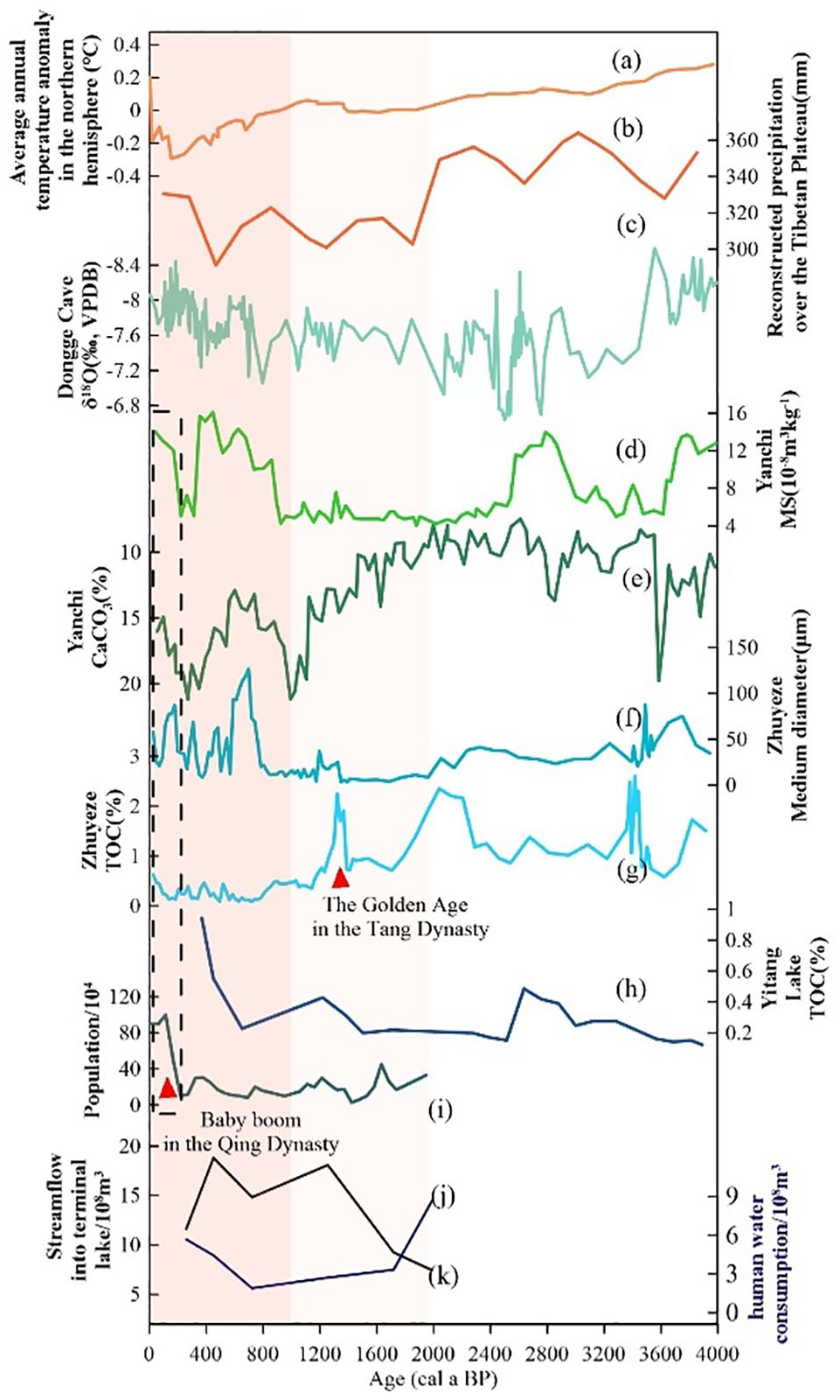
Changes in paleoenvironmental proxies from typical records since the Holocene. (a) Average annual temperature anomaly in the northern hemisphere (Hou et al., 2012) (b) Reconstructed precipitation over the Tibetan Plateau (Marcott et al., 2013). (c) Dongge Cave δ18O (Wang et al., 2005). (d)- (e) CaCO3 and MS from Yanchi Lake (Yu et al., 2006). (f)- (g) TOC and Medium diameter from Zhuyeze Lake (Li et al., 2012; Li et al., 2017). (h)TOC of Yitang Lake (Zhao et al., 2015). (i) Population of the Hexi Corridor over the past 2000 years. (j)- (k) Changes in elements of the reconstructed catchment water balance over the past 2000 years in the midstream and downstream of Heihe River (Lu et al., 2015).
Taking the Shule River as an example, we specifically review the dynamic process of the river over the past 2000 years. There should be at least three directions of runoffs on the alluvial flood fan of the Shule River: northeast, north, and northwest during the Han Dynasty, each flowing into a different area. Diverting water for irrigation, and changing the landscape led to a decline in the groundwater level during the 1900–1500 BP (Mao, 2008). People redevelopment the western and northern parts of the floodplain fan in the Tang Dynasty, resulting in reduced runoff to the northeast. The Hexi Corridor was occupied by ethnic minorities at the end of the Tang Dynasty. Destruction of agricultural land and waterways coupled with differences in livelihoods have led to the abandonment of oases and desertification (Li, 2003). After the Tang Dynasty, the northwestern runoff gradually declined and finally ceased to flow, the northeastern runoff gradually became the largest one, and the northward runoff was more or less stable (Zhang, 2010). Human activity was weak during this period, and river evolution is largely attributable to intrinsic behavior. During the Qing Dynasty, the Changma Dam was built at the mouth of the Shule River, making it possible for the Shule River to flow only to the northeast, and due to the lack of water, the ancient oasis to the northwest was completely desertified (Zhang, 2010). The study of the Hongshuiba River in the Hexi Corridor also shows that human activities were synchronous with northward migrations at 1100 BP (Pan et al., 2023). In the field investigation of the Hongshui River, we also found that the lateral erosion of the Hongshui River cut off the Great Wall of Han and that this lateral rerouting of the river is likely to have been affected by human-induced land-cover changes, and this kind of erosion has also been found in the study of the Loess Plateau (Figure 3e) (Zhao et al., 2022).
The evolution of rivers as a result of the interaction between climate change and human activity in the global endorheic zone during the Holocene
The majority of global endorheic zones are situated in arid and semi-arid regions, encompassing approximately one-fifth of the world’s land area (Meybeck, 2003). These zones have distinctive characteristics: being inland and bounded by topographic barriers, they lack hydrological connections with the ocean, resulting in a relatively independent hydrological cycle system. Simultaneously, their susceptibility to climate change and human activities is heightened due to water scarcity, wherein even minor fluctuations in water quantity within the basin can trigger the expansion or retreat of terminal lakes (Meybeck, 2003). We chose Lake Titicaca and the Tarim Basin to review the evolution of the river system during the Holocene period and to compare them with the fluvial zone of the Hexi Corridor.
Lake Titicaca is located at the northern end of the endorheic Altiplano basin high in the Andes on the border of Peru and Bolivia. The lake has been an important resource for people living in the region for millennia and is sensitive to climate variability on interannual to millennial timescales (Baker et al., 2005). The archeological record points to signs of human activity in this area dating back to around 10,000 BP, evidence of early human settlement is found in the form of primitive tools and artifacts discovered near the lake, suggesting that the lake’s early inhabitants relied heavily on hunting, gathering, and fishing for sustenance (Bruno, 2014). The lacustrine sedimentary record of Lake Titicaca generally indicates the low water level phenomenon of the lake in the early and Middle Holocene (Baker et al., 2005; Mourguiart et al., 1998; Wirrmann, 1987). This period of long-term falling lake levels has been attributed to reduced intensity of the SASM (South American Summer Monsoon) and lower amounts of precipitation (Baker and Fritz, 2015). Archeological research has documented the emergence of hunter–forager populations during this period, although population densities remained low largely (Capriles, 2014; Gayo et al., 2015). The Late-Holocene was a time of sweeping transformation on two counts: the lake heights went from decreasing to increasing, and the pattern of human livelihoods transitioned from hunting-feeding to an agro-pastoral life (Bruno, 2014; Capriles, 2014). The consistency between changes in the lake stage and shifts in livelihoods, suggests that the changes in the availability of water and arable land had consequences for people who resided around the lake. During this period, humans cultivated potatoes, quinoa, and maize along the fertile shores of the lake, and the domestication of llamas and alpacas also began during this period, providing a reliable source of wool, meat, and transport (Bruno, 2014). Changes in lifestyles have enhanced the impact of human activities, and Paduano et al suggested that the maximal pollen percentage of Chenopodiaceae/Amaranthaceae and the increase in Pediastrum abundance is due to human disturbance during the Late-Holocene (Paduano et al., 2003). Hippe et al used a multi-nuclide approach to quantifying soil erosion and found that compared to the Late Pleistocene-Holocene, the Late-Holocene erosion rate was an order of magnitude faster evident (Hippe et al., 2021). It is well established that soils become vulnerable to rain splash and sheetwash erosion when subjected to fire, grazing, or cultivation, which disrupt the capacity of plants to bind the soil. Thus, erosive change was linked to human activities such as deforestation, land clearance for agriculture, and herding intensification in the Late-Holocene of Lake Titicaca basin.
The Tarim River stands as the principal river in the Tarim Basin, with Lop Nur serving as the ancient river’s terminal lake and the depositional center of the entire basin. Findings indicate that the climatic attributes of the Tarim Basin are predominantly influenced by the westerly belt, exhibiting primarily synchronized periods of cold-wet and warm-arid conditions. These climatic variations play a crucial role in shaping the patterns of river runoff and lake levels in the region (Jia et al., 2017; Liu et al., 2016a; Yang et al., 2013). The Xiaohe culture was an early bronze culture in the region, disappearing in 3300 BP and the desiccation of the lake and the reduction of the surface water resources corresponded to the decline of the Xiaohe culture and the abandonment of the area (Zhang et al., 2017b). An arid environment existed between 3500–2600 BP and standing surface water was minimal or absent. The multi-proxy records of Lop Nur show that humid conditions between 2300 BP and 2100 BP, supported the ancient Loulan Kingdom until aridification began (Liu et al., 2016b, 2016c; Yang et al., 2006). The historical changes in the lake level were coincided with the ancient Loulan Kingdom’s collapse, showing that the dynamics of hydrological conditions in the catchment may have a direct influence on the fall of human settlement in drylands (Li et al., 2018; Shao et al., 2022). Scholars have actively debated the factors contributing to changes in water resources. The suggested reasons for its decline encompass climate change, marked by aridification, shifts in the course of the Tarim River, abandonment of the ancient Silk Road route, and diverse human activities, including conflicts, wars, and disputes over water for both irrigation and domestic needs (Mischke et al., 2019; Xie et al., 2021; Xu et al., 2017). In the Qing Dynasty, extensive farmland was cultivated in the middle and upper reaches of the Tarim River, resulting in a diminished downstream water flow. Subsequently, after the 1950s, both the human population and land reclamation activities experienced a notable increase (Yu et al., 2016). Aside from the construction of diversion canals, humans are inclined to erect barrages within rivers. This human intervention has led to alterations in the natural fluvial processes and morphology of the Tarim River, contributing to a reduction in the diversity of the river system. (Yu et al., 2016).
By comparing the Holocene river’s evolution in the three regions, we find that the impacts of climate change on river evolution are macroscopic and continuous, while the influences of human activities are local and disconnected, which is consistent with findings from other endorheic regions, such as Aral Sea, Ebinur Lake, Murray River and rivers in the arid southwest of the USA (Graf, 1988; Maheshwari et al., 1995; Sala, 2019; Wang et al., 2021). In contrast to the Hexi Corridor and the Tarim Basin, the Lake Titicaca area appears to experience less impact from human activities. This discrepancy is likely attributed to the higher altitude and comparatively more humid climatic conditions in the Lake Titicaca region, in contrast to the arid climate and delicate ecosystems found in the Tarim Basin and the Hexi Corridor. Additionally, the extended history of human activities in the Lake Titicaca area may contribute to a more harmonious coexistence with the environment, leading to reduced disturbances compared to the regions with a more recent and intensive history of human intervention. During the Holocene, human adaptations have primarily been attuned to the evolution of rivers. Humans engage in localized modifications through the allocation of water resources, which exert a noticeable influence on regional human endeavors and environmental changes. However, their impact is not significantly pronounced on the broader allocation of water resources across the entire basin or the overall evolution of the river system. With the progression of technology and increased utilization of tools, human activities such as dam construction, irrigation, and vegetation destruction through cultivation are prone to disrupt the delicate equilibrium between sediment flux and the transporting force driven by river discharge (Russell et al., 2021). This disturbance can result in a sequence of processes, including vertical erosion-deposition-lateral erosion alternation (Best, 2019; Chen et al., 2021; Gibling, 2018; Knox, 2001), and ultimately lead to outcomes such as channel abandonment, terminal lake droughts, among others (Wang and Li, 1983; Zhang, 2001). However, the influence of human activities on the environment varies across regions due to disparities in the stages of human civilization evolution. Agricultural civilizations typically exert a more significant transformation on the environment compared to pastoralism. Moreover, the timing of the Industrial Revolution and the level of technological development play crucial roles in determining the magnitude of the impact of contemporary human activities. In general, human-managed river systems initiate at diverse times in different regions, and as human intervention intensifies in river and sediment systems, the variability in river evolution becomes more pronounced.
Conclusion
We examine the development of river systems in the Holocene era within the Hexi Corridor. The comprehensive records and findings contribute to unraveling the intricate dynamics of river evolution across various stages, offering insights that form a foundation for understanding global endorheic zone river evolution. The findings indicate that climate change played a pivotal role in shaping the Hexi Corridor’s river system during the Holocene. Early human activities involved localized modifications through water resource allocation, minimally impacting the overall basin’s water configuration and river evolution. Notably, human influence on the river system in the Hexi Corridor gained prominence around 1000 BP, marking a stage of human domination. While the evolutionary stages of rivers in the Hexi Corridor share similarities with those in the global endorheic zone, the timing of human intervention in river evolution differs.
Supplemental Material
sj-docx-1-hol-10.1177_09596836241236344 – Supplemental material for The evolution of river systems under the influence of climate change and human activities in the endorheic zones during the Holocene
Supplemental material, sj-docx-1-hol-10.1177_09596836241236344 for The evolution of river systems under the influence of climate change and human activities in the endorheic zones during the Holocene by Mingjun Gao, Yu Li, Zhansen Zhang, Junjie Duan, Yaxin Xue, Simin Peng, Hao Shang and Shiyu Liu in The Holocene
Footnotes
Funding
The author(s) disclosed receipt of the following financial support for the research, authorship, and/or publication of this article: We acknowledges the support by the National Natural Science Foundation of China, No. 42371159, 42077415; the Second Tibetan Plateau Scientific Expedition and Research Program (STEP), No. 2019QZKK0202.
Supplemental material
Supplemental material for this article is available online.
References
Supplementary Material
Please find the following supplemental material available below.
For Open Access articles published under a Creative Commons License, all supplemental material carries the same license as the article it is associated with.
For non-Open Access articles published, all supplemental material carries a non-exclusive license, and permission requests for re-use of supplemental material or any part of supplemental material shall be sent directly to the copyright owner as specified in the copyright notice associated with the article.