



Abstract
This paper revisits the geographical legacy of socialism in the urban areas of the former Soviet Union. Building on research on housing and socio-spatial differentiation under and after socialism, this will be achieved by examining an important component in the spatial differentiation of the city, namely neighbourhood reputation. The analysis is based on survey data (n = 1515) from the city of Ust’-Kamenogorsk, Kazakhstan; a combination of descriptive statistics and multivariate logistic regression are deployed in order to shed light on the factors that are associated with the reputation of the neighbourhoods in which people reside. The results show that the Soviet system manufactured its own brand of socio-spatial distinction, which reflected the priority hierarchies built in the socialist planned economy. Education, age and, most importantly, area of employment appear to have been ‘rewarded’ with prestigiously located housing.
Introduction
There is plenty of evidence in support of the notion that, given its intentions, state socialism did not succeed in creating a fair and equitable system of housing allocation in the Soviet Union and its satellite states (Gentile and Sjöberg, 2013; Morton, 1980; Szelényi, 1983). Instead, while market forces were not allowed to operate (openly) on socialist soil, a number of other endogenous structural forces meant that housing resources were distributed unequally with regard to socio-economic (Alexeev, 1988; Morton, 1980; Pickvance, 1988; Szelényi, 1983) and socio-professional status (Domański, 1997; Gentile, 2005; Shomina, 1992), as well as to ethnicity (Gentile and Tammaru, 2006; Kulu, 2003; Ladányi, 1989; Ruble, 1989; Smith, 1989). In other words, ‘socialist’ housing inequalities have been observed in countries with both relaxed (e.g., Hungary) and orthodox communist regimes (e.g., the Soviet Union).
Of course, within the urban context the location of a dwelling is at least as important as its physical characteristics in terms of floor space or facilities. Unfortunately, the literature is far less exhaustive when it comes to the spatial aspect, which is hardly surprising given the scarcity of spatially disaggregated data covering the socialist period or its subsequent decade. By necessity, the few studies that do exist are limited to crude descriptions of socio-spatial patterning, building on spatial units such as the urban rayony (e.g., Ruble, 1995). These are urban districts that tend to be very large, sometimes counting hundreds of thousands of inhabitants. Nevertheless, findings from late-Soviet Moscow indicate that, even at this scale, both social status and district prestige were easy to trace (Barbash, 1988; Sidorov, 1992). More recently, however, scholars have been able to make use of historical census data at the census enumeration tract level. This has opened up a new research front on residential segregation under socialism and after that makes use of traditional tools such as the global indices (of dissimilarity, segregation, isolation, etc.) as well as various methods to measure spatial concentration and clustering (Marcińczak, 2012; Marcińczak et al., 2013, 2014; Marcińczak and Sagan, 2011). Led by Polish geographer Szymon Marcińczak, this research direction is largely based on detailed univariate pattern description and analysis. Significantly, the results put established beliefs on post-socialist urban transition into question: socialism, it emerged, produced somewhat more socio-spatially segregated cities than what was to follow with the intervention of market forces. While this condition may be temporary – after all, urban transformations take place more slowly than the reformation of the political and institutional conditions that frame it (Sýkora and Bouzarovski, 2012) – it discloses the existence of two major gaps in the current state of the art on the social geography of urban change in Central and Eastern Europe (CEE). Firstly, the recent evidence suggests the socio-spatial expressions of real socialism have yet to be fully identified, let alone understood. Consequently, secondly, the interpretation of the post-1989/1991 trends is impaired by the inadequacy of our knowledge about the starting point, leading to misguided assessments of the influence of market forces on post-socialist segregation involving confusion and conflation between segregation patterns and processes (see Marcińczak et al., 2013).
In recognition of these problems, this paper’s main aim is to revisit the geographical legacy of socialism in the urban areas of the Soviet Union. Building on kindred research on housing inequalities under and after socialism (Domański, 1997; Gentile and Tammaru, 2006; Hess et al., 2012; Kulu, 2003), this will be achieved by introducing an important component in the spatial differentiation of the city, namely neighbourhood prestige or reputation. To do so, this paper will identify the socio-economic and ethnic characteristics of the population inhabiting more and less prestigious neighbourhoods in Ust’-Kamenogorsk, 1 a mid-sized city in the northeastern corner of Kazakhstan. Moreover, because much of the Soviet city’s housing stock was under ‘industrial control’ (cf. Domański, 1997), the link between the priority status of the Soviet-era landlords and the locational quality (prestige) of the neighbourhoods in which these landlords were active will be explored.
The analysis will build on survey data from Ust’-Kamenogorsk (pop. 310,000 at the time of the closest 1999 census) collected by the author in cooperation with the East Kazakhstan oblast’ (regional) statistical authority in 2000–2001. At that time, the city’s built fabric was almost completely unchanged when compared to the year of the Soviet Union’s collapse, while residential mobility was low due to the severity of the economic crisis caused by the demise of central planning. Because of this, the year 2000 provides an approximate snapshot of the spatial structures that existed in Ust’-Kamenogorsk, both under late socialism and during the first decade of transition.
This paper continues with a literature review focusing on housing and socio-spatial inequalities under socialism and during the early transition, from which appropriate research questions will be extrapolated. This will be followed by a brief description of the case study city. Next, the data and methods used in the analysis will be outlined, with particular attention being paid to the selection of variables to be included in the results, which will be reported in the paper’s penultimate section. The final section presents the study’s conclusions.
Socio-spatial patterns under socialism and in the first decade of post-socialism
Like most cities, and notwithstanding the long duration of the great socialist standardization experiment, the urban texture of cities across the Soviet Union retained a certain degree of diversity, not least within housing, which was differentiated by both quality and quantity with respect to location, age, building materials, access to main utilities, privacy (i.e., whether private or shared with other families), and so forth. This was the context within which socialist policies of equitable housing allocation had to operate, and this was also the context that was gradually intended to be abandoned and transformed in favour of an alternative urban vision – homopolis – in which spatial homogeneity was supposed to replace the unjust diversities of the past. In the long run, therefore, cities were supposed to assume a more homogenous spatial structure and, accordingly, the just distribution of de facto equal or almost equal housing resources would have followed suit (Gentile et al., 2012). Meanwhile, a helping hand would have come from the compression of the social hierarchy and the abolition of the divisions engendered by it. In the long run, most urban inequalities would have vanished, not least within housing, where objective parameters based on need would have guaranteed complete equity, or at least randomness in distribution, both with regard to physical quality and locational assets. However, neither the spatial differentiation of different social groups nor the existing housing inequalities squared in with this picture.
Despite the absence of ‘hard’ evidence, the literature on socio-spatial differentiation under socialism is largely in unison in suggesting that various forms of residential segregation indeed did exist notwithstanding these egalitarian ambitions, and that they were not always – and perhaps not often – relics of the capitalist past (Bater, 1989; Borén and Gentile, 2007; Ciechocińska, 1987; Dangschat, 1987; Hamilton and Burnett, 1979; Ruble, 1995; Smith, 1996; Szelényi, 1983). Moreover, the socialist city exhibited a certain degree of ethnic housing inequalities and ethno-spatial patterning (Gentile and Tammaru, 2006; Hess et al., 2012; Kulu, 2003; Ladányi, 1993; Ruble, 1989; Rukavishnikov, 1980; Smith, 1989), which has been associated with outright discrimination, or ‘politically imposed segregation’ (Temelová et al., 2011), as well as with more indirect influences exerted by the association of housing to different industries operating in an ethnically segmented labour market (Tammaru, 2001). Although moderate by ‘capitalist’ standards, the very fact of the existence of urban inequalities in the quality, location and allocation of housing under socialism is of greater theoretical interest than the actual spatial expression of these inequalities because it exposes the gap between the socialist system’s professed ideal and the reality that it produced, which includes wide variation. For example, the ancient cities of Soviet Central Asia (Samarqand, Bukhara, Tashkent, etc.) largely preserved their pre-revolutionary division into strictly planned ‘European’ (and prestigious) neighbourhoods and the more ancient dense ‘Asian’ quarters (Giese, 1979), whereas the Russian-speaking population of the Baltic republics was almost completely absent from the single-family housing sector that developed under socialism (Hess et al., 2012; Kulu, 2003).
While the degree and spatial expressions of social and ethnic residential segregation under socialism remain disputed, the most important divisive line in the literature runs between those who viewed socialist-era segregation as a dwindling relic from the precedent bourgeois epoch (e.g., Matějů et al., 1979; Węcławowicz, 1979), and those who (in addition) identified a new, socialist-made, source of socio-spatial sorting and housing inequality, which is interpreted as a corollary of the system’s inability to curb the endemic housing shortage (e.g., Domański, 1997; Gentile and Sjöberg, 2006; Morton, 1980; Szelényi, 1983). However, different – but also complementary – explanations regarding how the shortage influenced the socio-spatial development of the socialist city have been advanced. For Szelényi (1983), whose study on two mid-sized Hungarian cities indicated that young educated families were preferentially being allocated apartments in (then) coveted apartments in the new housing estates built on the urban fringe, the explanation lay in the fact that rationing encourages allocation by social merit while downplaying the criteria used for assessing actual need. Morton (1979, 1980) similarly ‘blames’ the administrative housing allocation system, but rather denounces its inability to live up to its own standards because of widespread corruption. Indeed, the allocation process appears to have produced housing inequalities in different contexts over the entire time span of the socialist regimes’ existence (Alexeev, 1988; Gentile and Sjöberg, 2013; Parkins, 1953; Pickvance, 1988), but it is not yet known whether these inequalities also had a spatial dimension. Finally, building on Janos Kornai’s shortage economy approach (1980, 1992), a third line of explanation assembles its argument on an assessment of the overall diseconomies of central planning, suggesting that shortages – not just of housing and consumer goods, but also of producer goods, labour and other inputs – substantially alter the behaviour of individual agents acting in the economy, from the large industrial enterprise director down to the individual consumer. To the extent that this behaviour involves investing in housing to attract or retain short-supplied labour, an effect on the socio-occupational spatial structure of the city may be expected (Gentile and Sjöberg, 2006). Following pioneering work by Sjöberg (1999), which was subsequently applied to the internal structure of socialist urban areas by Gentile and Sjöberg (2006, 2010a, 2010b), this perspective is termed the ‘landscapes of priority’ model of socialist urban development. Supported by earlier observations about the role of the industrial ministries in producing urban social inequalities, (Bater, 1980; Domański, 1997; Herman, 1971; Lewis and Sternheimer, 1979; Shomina, 1992), this model weighs the individual contributions of multiple economic agents with different priority positions to the city’s spatial structure, suggesting that high-priority enterprises are able to exert enough influence on urban development so as to substantially alter its course in their own favour (and at the expense of the less prioritized actors in the urban economy). Accordingly, the workers of high-priority enterprises would be given privileged access to better quality housing, possibly at a better location, and with less time spent waiting. Also, the relative importance of these three privileges is assumed to vary over time, as the initial urgency related to the acute housing shortage gradually eased, facilitating a ‘qualitative turn’ towards location and improved design (Gentile and Sjöberg, 2006). The curious consequence of this state of affairs is that while the working class as a whole was able to gain unprecedented access to modern housing, often on a par with what was available to Soviet managers, new divisions emerged within the working class itself, whereby certain segments splintered off as members of a new ‘prolelitariat’ (Gentile and Sjöberg, 2006). For sure, there were far more Metallurgical workers’ Palaces of Culture in the USSR than there were textile or food-processing workers’ ditto. A similar situation characterized the housing sector, and workers considering different places of employment had all the incentive to mind the gap.
With the demise of socialism, a general feeling of ‘case closed’ spread within the research community. Socialist cities – or so it was assumed – were characterized by low levels of socio-spatial differentiation (cf. Sýkora, 1999; Szelényi, 1996; Vendina, 1997; Vesselinov, 2005; Węcławowicz, 1998), and while these levels varied between cities, certainly the post-socialist reforms would have increased segregation to normal market levels, often within a discourse that sets the Western European model of urban development as its backlog (Wiest, 2012). Some scholars have gone so far as to claim that the post-socialist cities are in fact undergoing not just increased socio-spatial differentiation, but even polarization (Brade et al., 2009; Polanska, 2011; Sailer-Fliege, 1999; Węcławowicz, 1998).
However, the case is not yet closed, for these assumptions are seldom armoured with empirical evidence. In fact, with the exception of the works by Marcińczak and colleagues (Marcińczak, 2012; Marcińczak et al., 2013, 2014; Marcińczak and Sagan, 2011), there are very few studies that actually measure the quantifiable extent and spatial patterns of socio-spatial differentiation after socialism (Prelogović, 2009; Ruoppila and Kährik, 2003; Sýkora et al., 2006; Sýkora, 2009), whereas there is a wealth of works on the processes that transform these patterns, some of which strike the eye more than they influence the aggregate statistics (e.g., the burgeoning literature on gated housing and residential communities in post-socialist countries, cf. Blinnikov et al., 2006; Hirt and Petrović, 2011; Polanska, 2010; Stoyanov and Frants, 2006). The few works that do exist suggest that social residential segregation during the first decade of transition remained low (Ruoppila and Kährik, 2003; Sýkora, 2009). More so, as the Polish case indicates, it may even have decreased somewhat since the socialist epoch (Marcińczak et al., 2013), challenging many of the assumptions made by scholars during the past 20 years.
The literature is equally scant with regard to the ethnic dimensions of segregation: with the exception of Tátrai’s (2011) work on the multiethnic cities of Transylvania, the little there is is either based on limited datasets (Gentile, 2003; Kopasz, 2004; Vendina, 2002) or on aspatial analysis strategies (Gentile and Tammaru, 2006; Hess et al., 2012). Because there are no studies that compare ethnic segregation in Central and Eastern European cities over time, it is not possible to draw any firm conclusions as to the effect of the post-communist reforms within this sphere.
Summing up, the state of the art on socio-spatial and housing differentiation, as well as on the associated inequalities, under socialism and in the early years of transition is rather ambiguous. On the one hand, the causes and mechanisms generating segregation under socialism are well known, even though their relative weight may be a matter of disagreement. On the other, the geographical expressions of the urban social inequalities that characterized the socialist city and its immediate successor have only been explored to a limited extent, stymieing the understanding and interpretation of socio-spatial developments after socialism. Therefore, this paper addresses the following research questions:
What are the socio-economic characteristics of the population that inhabits more and less prestigious neighbourhoods of the socialist and early post-socialist city?
Given that much of the Soviet city’s housing stock was under the direct or indirect control of subjects of industrial ministries, does the priority status of these former landlords (via the factories) predict the locational quality (prestige) of the neighbourhoods in which the housing they used to administer is located?
Is the residents’ ethnicity associated with the locational quality (prestige) of the neighbourhoods they inhabit?
While the first and third questions aim at capturing some ‘classical’ features that predict residential location, the second question implicitly puts the Gentile-Sjöberg (2006) landscapes of the priority model to test. In order to validate the model, especially with regard to its spatial predictions, the results would have to show that the high-priority enterprise housing is associated with prestige locations. Before moving on to the description of the data and methods used to answer these questions, this paper proceeds with a general presentation of the case study setting.
Ust’-Kamenogorsk
Hovering around 300,000 inhabitants, Ust’-Kamenogorsk is one of Kazakhstan’s major industrial hubs, specializing in non-ferrous metallurgy. As the oblast’ (province) administrative capital, it hosts important local and regional functions, including the regional administration, universities and higher-order commercial facilities. As elsewhere in the urban areas of the northern half of Kazakhstan, the city is largely Russian-speaking.
During the Soviet epoch, and particularly during and after WWII, Ust’-Kamenogorsk grew rapidly. This was the result of the establishment of three major metallurgical enterprises (the Lead-Zinc Combine, the Ul’ba Metallurgical Plant and the Titanium-Magnesium Combine), which form the city’s major industrial base. The production at the Ul’ba Metallurgical plant (uranium, beryllium, tantalum and other rare metal products) was completely steered towards the needs of the Soviet military and nuclear effort, which placed this enterprise in a particularly privileged position within the national hierarchy of economic priorities. Moreover, it also wrapped significant segments of the population (the plant’s thousands of workers) in a veil of severely enforced secrecy, while the city as such was shut off to outsiders. Because of this industrial legacy, the city has a notorious reputation for its environmental pollution, which is highly linked to the three main metallurgical enterprises active in the city and, to a lesser extent, the thermo-electrical power generation facilities. In addition to relative centrality, the location of the city’s major pollutants is an important factor in the formation of the residential preferences of the local population (Gentile, 2005).
By Central Asian standards, the overall housing situation in the city is good, but this conceals significant differences in quality and relative location. Similar to other important industrial centres across the socialist realm (Bater, 1980; Domański, 1997; French, 1995; Gentile and Sjöberg, 2006; Shomina, 1992), much of the multi-family housing stock is historically connected to one of the high-priority major metallurgical enterprises. Conversely, the single-family housing sector frequently occupies residual spaces and is of generally low technical quality, evoking a well-known pattern of CEE and post-Soviet urban morphology under socialism (cf. Andrusz, 1984; Borén and Gentile, 2007; Szelényi, 1983).
Data, methods and variables
The data stem from the Cities of the Rudnyi Altay sample survey, which was held between 27 December 2000 and 20 January 2001 by the oblast’ statistical office in Ust’-Kamenogorsk under the supervision of the author. The survey was conducted using the face-to-face method following an extended period of initial advertisement in the local media. The sample (n = 1515 valid cases) was extracted systematically (every 77th household) from the alphabetical household register created on occasion of the 1999 population census of the Republic of Kazakhstan. Following common practice of the time and in the absence of an adequate individual-level sampling frame, a quota scheme was used within the households to select individuals in order to obtain an adequate demographic structure; also, the minimum required age for participation was 18 years. This was necessary to reduce the skewness of the sample’s age–sex structure, which is a typical problem even when intra-household randomness techniques are deployed carefully (e.g., the Kish table or the birthday method, see Gaziano, 2005; Grandjean et al., 2004), but came at the cost of the randomness of the intra-household sample, which is more reliable in relation to household-level variables than to individual-level variables. However, despite the attempts to bring the sample in line with the city’s age–sex structure, the sample remains skewed towards women. The degree of this bias is difficult to establish because the sample only includes the adult population, which has a higher share (unknown) of women than the full population of the city (54 per cent) because of very high adult male excess mortality. In this paper, this matters less because the most important variables are based on the household or dwelling level, whereas the age and ethnicity 2 (and possibly also education) of family partners tend to correlate. 3
For the individual-level variables not to be representative, the responses would have had to systematically depart from the expected values, which was not the case when compared to the statistical office’s own calculations.
The response rate was very high (almost 93 per cent) because of three important conditions: (a) broad advertising; (b) the participation of a state authority; and (c) the fact that the respondents were paid the (then) equivalent of about 0.35 USD (50 KZT) for their participation.
The data are analysed using both descriptive statistics and a set of binomial multivariate logistic regression models. The core aspect of the paper – the reputation of the neighbourhoods in which people reside and the social and physical characteristics that predict this reputation – was measured by asking each respondent to evaluate each one of 35 urban neighbourhoods (Figure 1) on a five-point Likert scale, where a score of 1 is equal to ‘very bad’ and 5 to ‘very good’. Because it does not force the respondents to order neighbourhoods to which they are indifferent, this strategy is preferable to ranking, which typically produces unreliable results for mid-range neighbourhoods (Thill and Sui, 1993). Moreover, all respondents were familiar with this grading system, as it was analogous to the one that had been in use in schools and universities for decades.
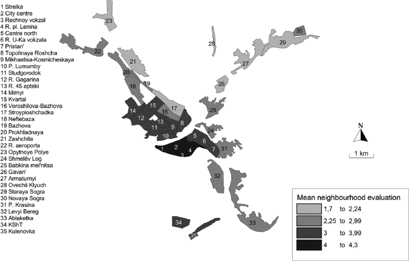
Location of city neighbourhoods and mean neighbourhood evaluation scores (scale 1-5). Source: survey.
The 35 districts have names and were easily recognizable by almost all respondents; moreover, they were tested successfully during the course of a small pre-survey pilot study (n = 64). Because the survey was conducted face-to-face, the interviewers were also able to clarify the location and ‘contents’ (streets, stores and other objects) of each neighbourhood when the respondents expressed uncertainty about the location or boundaries. This was rarely necessary, as the neighbourhood labels turned out to be stable markers of specific urban areas, which was facilitated by the fact that the physical structures of the Soviet city tended to stay put once in place, generating ‘stiff landscapes’ (Borén, 2009) that were gradually memorized by their inhabitants. Moreover, Soviet town planning theory and practice favoured the formation of more easily recognizable neighbourhoods, the delimitations of which (broad avenues, clearly defined industrial wedges, clear catchment areas for homogenously priced stores, etc.) would have appeared to be much more obvious than, for example, in the case of the more diversified Western European city (cf. Jenks and Dempsey, 2007).
The dependent variable in the regression models is the mean evaluation of the neighbourhood in which each individual resides. This way, the dependent variable fulfils the double purpose of measuring two latent variables: neighbourhood prestige or reputation per se (as in Permentier et al., 2008) and the fact of residence in neighbourhoods with different prestige or reputations. The empirical core of the study is based on three binomial logistic regression models, each with a different cutting point along the mean neighbourhood prestige scale. 4 The first model distinguishes the ‘bad’ neighbourhoods from the rest, drawing the line at a mean score of 2.25 points (a lower cutting point would have resulted in an insufficient number of cases). The second model’s cutting point is in the middle of the Likert scale (3 points). In the third model, the ‘good’ neighbourhoods (with a mean score of 4 or more points) are distinguished from the rest.
Five statistically significant independent variables were included in the study. 5 Three of the variables relate to individual characteristics (age, passport ethnicity and education), one to the household (household income divided by the number of household members) and one to the Soviet-era origin of the dwelling (the dwelling’s landlord before the end of the Soviet era). Additional socio-economic and demographic variables were also controlled for (gender, civil status, latest migration/mobility history), but they were excluded from the final models because of low statistical significance, low contribution to the overall variance explanation (the Nagelkerke pseudo-r2) and/or multicollinearity problems. Moreover, concerning gender, this sample does not include any information on the precise family member through which the dwelling was allocated. This means that we cannot expect men and women to reside in neighbourhoods with different levels of prestige. 6
The inclusion of the first variable is motivated by the fact that age is traditionally associated with various aspects of housing (Chevan, 1982; Green and Hendershott, 1996) and, most importantly, life cycle stages are associated with differing housing needs, both with respect to size and location (Rossi, 1955). However, the Soviet context provided different incentives that offset this ‘natural’ course in the relation between households and the housing they occupy. First of all, for most people, receiving a full apartment (as opposed to a fraction of one) was a once-in-a-lifetime event (Andrusz, 1984; French, 1995; Morton, 1980). Secondly, with nominal rents, low costs for utilities and secure lifetime contracts, there was little incentive to move at all. Because the elderly residents most likely received their apartments at a young age, a long time ago, and in more centrally located areas (which are considered to be more prestigious, and where much of the new residential construction took place initially), one may expect the elderly to be over-represented in the more prestigious neighbourhoods.
The second variable, ethnicity, is defined as the ethnicity (natsional’nost’ in Russian) recorded in the respondent’s passport (in addition to citizenship – this is a Soviet practice that is gradually disappearing). In the non-Russian republics of the Soviet Union, the titular ethnic groups were relatively disadvantaged in the housing allocation process. In Latvia, it appears that Latvians had a lower probability of being assigned an apartment than Russians (Gentile and Sjöberg, 2013), and a similar pattern emerged in both Estonia (Hess et al., 2012; Kulu, 2003) and in Kazakhstan (Gentile and Tammaru, 2006). Because of the spatial differentiation of the housing stock, these ethnic inequalities were also reflected in discernible spatial patterns (cf. Gachechiladze and Bradshaw, 1994; Rukavishnikov, 1980). This was the result of regional variants of the troika of industrialization, urbanization and the policy of ‘merging people’ (i.e., Russification) that resulted in the ‘underurbanization’ (cf. Konrád and Szelényi, 1977; Murray and Szelényi, 1984) of titular ethnic groups (Tammaru, 2001). Within cities, the latter had less trouble gaining access to the single-family segment of the housing stock, which was often of poorer quality (Gentile, 2003; Giese, 1979; Shomina, 1992), although not necessarily less desirable from the perspective of the residents. In the regression models, ethnicity is controlled for in order to assess whether this disadvantage in housing also carried into its locational aspects, as appears to have been the case in Hungary (Szelényi, 1983).
Because of its direct association with social status under socialism (Dobson, 1984), and building on existing evidence of residential segregation by education and socio-occupational status under socialism (cf. Marcińczak, 2012; Marcińczak et al., 2012, 2013, 2014), a trichotomized education variable (primary or less, secondary, higher education) is included.
Monetary income did not necessarily mean much under socialism, because of the nominal character of the rents that were charged. However, with the demise of socialism, money started to ‘sing’ (Ruble, 1995). Therefore, with the assumption that those who are able to afford moving to more prestigious neighbourhoods will in fact do so, income is expected to predict residential location.
Finally, the fifth included independent variable – the latest Soviet-era landlord – puts the intra-urban landscapes of priority model to test. While the initial conceptualization of the model (Gentile and Sjöberg, 2006) suggested that the relative economic priority (as seen from Moscow) of the Soviet or socialist-era landlord would predict not only the quality but also the relative location of the buildings erected under its auspices, evidence presented later has been mixed (Gentile and Sjöberg, 2010a, 2010b; Sommer, 2012), possibly because of the relatively moderate differences in priority accorded to the industries hosted by the cities being analysed. The present case study city, Ust’-Kamenogorsk, is a completely different type of city, where a top priority enterprise (the Ul’ba Metallurgical Plant) coexists with numerous low-priority servicing enterprises, as well as with a mix of mid-sized and large industrial enterprises at different positions on the scale of Soviet-era economic and political priorities. Therefore, if the intra-urban landscapes of priority model were to fail the test in this paper, it would probably deserve rejection.
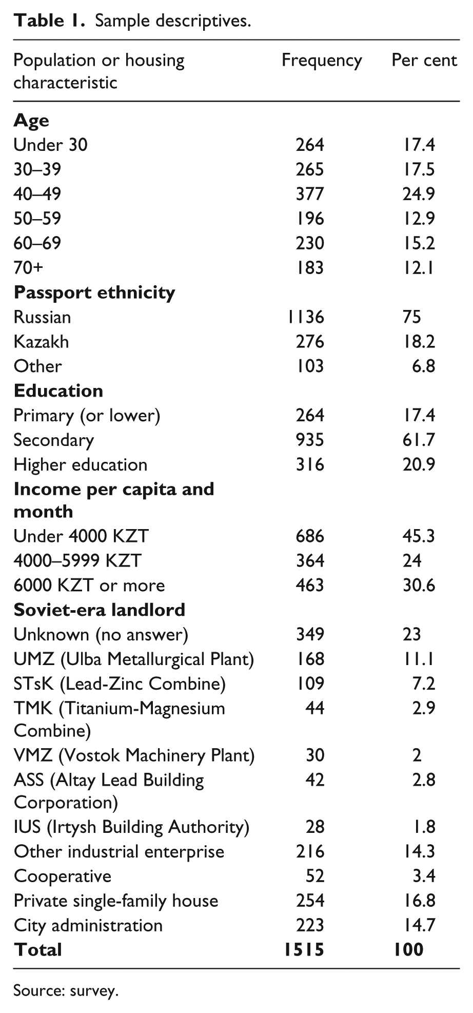
The sample descriptive statistics are visible in Table 1. The sample’s age distribution is reasonable; the 50–59 cohort displays a classical World War II dent in the population pyramid. The ethnic distribution of the population is also in line with the official statistics (Gentile and Tammaru, 2006). The educational structure indicates that the vast majority of the population is high-school educated, which includes many with secondary technical education, while the size of the group with primary education (or less) is comparable to the group that has higher education. The income structure is relatively compressed, despite some anomalies and likely under-reporting. The large size of the low-income group depends on the fact that almost all retired individuals received a low monthly pension payment, very often the minimum 3000 KZT (just over 20 USD at the time). Finally, as expected given the industrial focus of the city (cf. Bater, 1980; Shomina, 1992), and contrary to the case of the more diversified Baltic cities of Daugavpils (Gentile and Sjöberg, 2010a) and Tartu (Sommer, 2012), the major industrial enterprises dominate(d) the housing scene in Ust’-Kamenogorsk. In fact, the share built under the auspices of the city administration – the main body responsible for the task of building housing – is only slightly larger than the share built by the Ul’ba Metallurgical Plant, which was the city’s highest priority enterprise, for the exclusive use of its workers and their families. By the time of the survey, about three quarters of the city’s apartments had been privatized, mostly in 1992 or 1993. Unsurprisingly, the Ul’ba residents were, relatively speaking, early privatizers, as were those living in ‘good’ or ‘above-average’ neighbourhoods. 7
Sample descriptives.
Source: survey.
Results
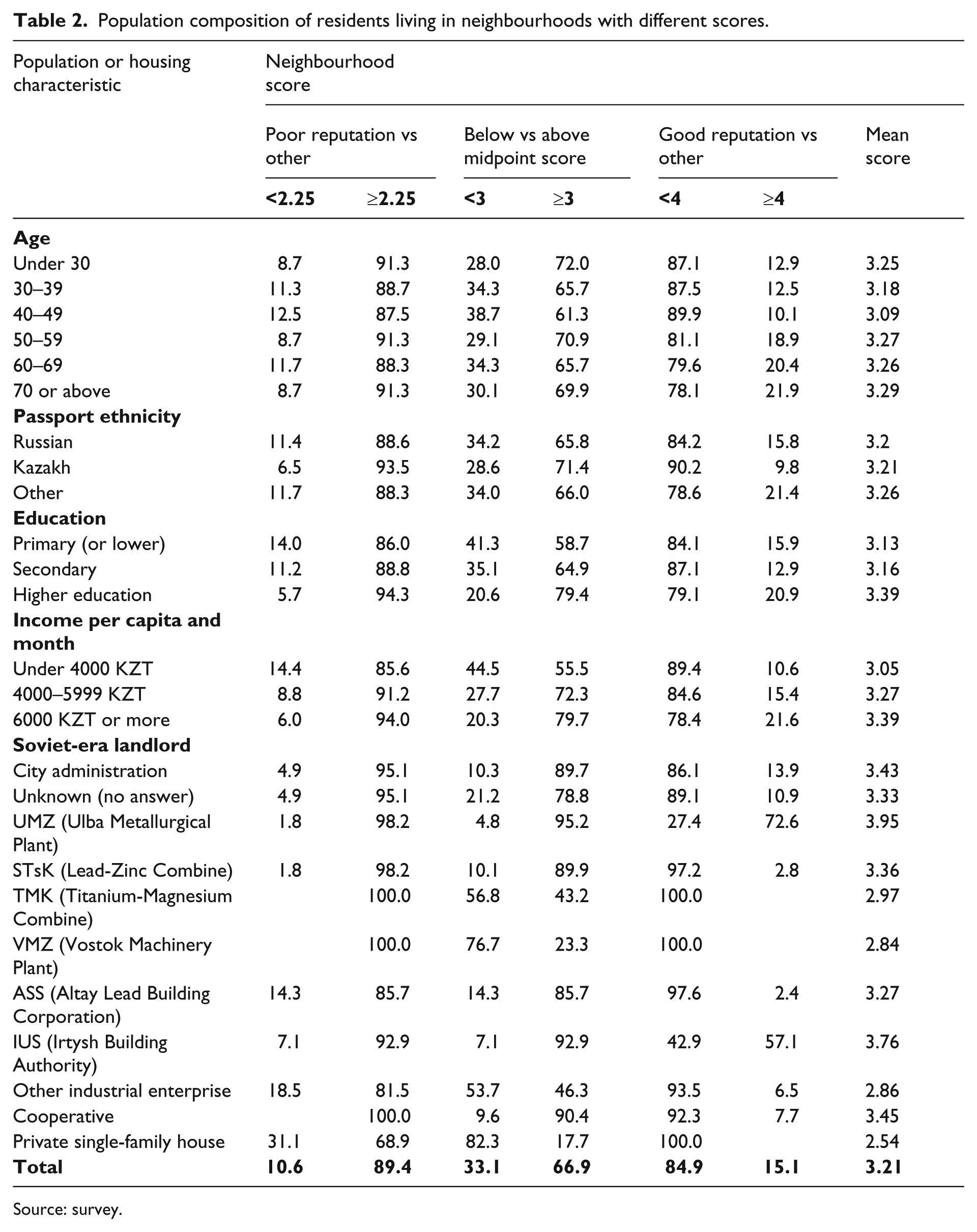
The results section will start with a bivariate crosstabulation of the dependent variables against the five independent variables. This will be followed by the main results of the paper, which are contained in the binomial logit models. Table 2 shows the share of the respondents living in neighbourhoods of different reputations, and Figure 1 reveals the geography of the evaluations of the city’s neighbourhoods. On aggregate, little over 10 per cent of the population lives in poorly reputed neighbourhoods, about one third in neighbourhoods with scores on the lower half of the five-point Likert scale, and approximately 15 per cent in the most prestigious areas. The elderly residents are over-represented in the prestigious areas, while the younger cohorts are under-represented. Ethnic background does not appear to be associated with neighbourhood reputation, although the Kazakhs appear to be fewer in the lowest and highest prestige neighbourhoods. Expectedly, higher education is associated with a higher degree of residence in ‘good’ areas, 8 while primary education alone is more frequent in ‘bad’ or ‘below-average’ areas. Household per capita income produces similarly predictable results: higher incomes are associated with living in better neighbourhoods, while the opposite is true for lower incomes. Finally, the locational quality of the dwellings appears to be stratified in accordance with the Soviet-era landlord, providing some preliminary support for the intra-urban landscape of priority model (Gentile and Sjöberg, 2006). While this support will have to be corroborated within the multivariate setting, it is already here worth noting that more than 95 per cent of the dwellings previously administered by the Ul’ba Metallurgical Plant (Ul’binskii Metallurgicheskii Zavod or UMZ) are located in above-average neighbourhoods, with almost three quarters being in the city’s most prestigious locations (specifically, the environs of Lenin Square and the scenically located high-rise estate of Strelka – both located in the city centre and characterized by a superior living environment). The Irtysh Construction Administration (Irtyshskoe Upravlenie Stroitel’stva or IUS) was also strongly present in the most desirable parts of the city, which is not surprising, as this organization was directly linked to the UMZ (Gentile, 2005). At the other end of the priority scale, more than half of the ‘other’ industrial enterprises’ dwellings are located in areas considered as below average, and almost one fifth are in poorly reputed neighbourhoods. This is because much of the low-priority enterprise housing stock was raised in the vicinity of the production units rather than in the city centre, often on peripheral or polluted sites (or both). Following a predictable trend, the midway priority enterprises appear over-represented in either the above- or below-average categories, with a limited presence in the lowest or highest reputed neighbourhoods. This pattern is comparable to the one displayed by the city administration and cooperative segments of the housing stock. Finally, the private single-family housing sector clearly occupied residual or marginalized spaces, as over 80 per cent is located in below-average neighbourhoods, and almost one third (i.e., three times the total share) in ‘bad’ neighbourhoods. This pattern suggests that the respondents frequently conflate single-family housing per se with low neighbourhood prestige, which reflects the typical socialist-era distinction between attractive modern housing in high-rise estates and backward (also ideologically) horizontal housing with poor facilities (cf. Bater, 1980; Gentile and Tammaru, 2006; Szelényi, 1983).
Population composition of residents living in neighbourhoods with different scores.
Source: survey.
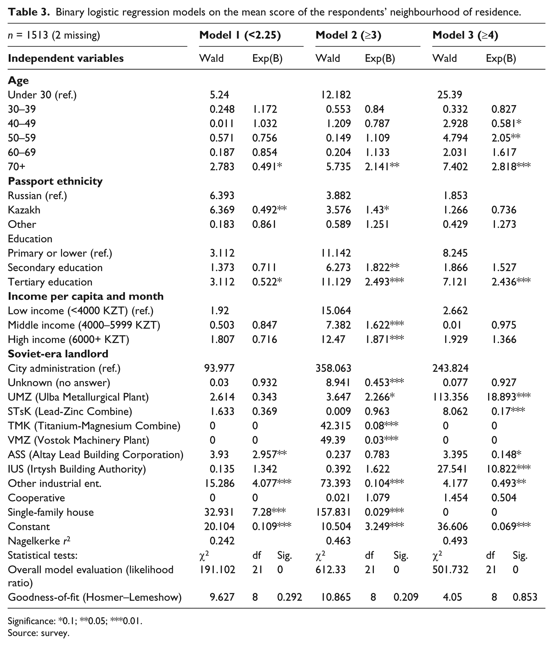
The multivariate binomial logistic regressions (Table 3) allow the variables to control for each other and are therefore essential to gauge the actual independent contribution of each aspect in predicting the outcome in terms of the locational quality of the neighbourhoods in which the respondents reside. The Exp(B) coefficients are read as odds ratios vis-à-vis a given reference category, where 1 represents equal odds, whereas the Wald statistic denotes the contribution of each variable to the model. Model 1 compares those living in ‘bad’ areas with the rest. The basic odds for this are 0.12. The regression results indicate that seniority (age ≥70, compared to those aged under 30), being a Kazakh (compared to Russian) and having a higher education (compared to those with primary education or less) give 0.5 times the odds of living in such areas; income, on the other hand, makes no statistically significant contribution. Most importantly, however, two Soviet-era landlords – the ‘other’ enterprises (odds of more than 4, compared to the city administration’s own apartments) and the Altay Lead Building Corporation 9 (ASS, or AltaySvinetsStroy, odds of almost 3) – and especially the private (single-family) housing sector (odds of over 7), are associated with low-prestige neighbourhoods.
Binary logistic regression models on the mean score of the respondents’ neighbourhood of residence.
Significance: *0.1; **0.05; ***0.01.
Source: survey.
In Model 2, the population living in above-average areas is compared to the rest, and the basic odds for this are 2.02. In this case, the impact of old age (≥70) is reversed, with the odds of living in such neighbourhoods being of more than 2, and with the significance increasing to the five-per cent level. Kazakhs also have slightly greater odds of living in above-average areas (odds 1.4, significance at the 0.1 level), while the independent impact of both education and income is moderate-to-strong and highly significant, especially for those with higher education (odds almost 2.5). However, it is yet again the former landlord that predicts the most dramatic outcomes: while former UMZ housing has more than twice the odds of being located in above-average areas, the odds for the ‘other’ enterprise housing and for single-family housing to be in such privileged locations are extremely low (0.1 and 0.03, respectively). Also, the Titanium-Magnesium Combine (TMK, or Titano-Magnievyi Kombinat) and the Vostok Machinery Plant (VMZ, or Vostochnyi Mashinostroitel’nyi Zavod) housing have extremely low odds of being located in above-average neighbourhoods; however, as we saw, they did not exist at all in the poorly reputed neighbourhoods (nor do they exist in the highly reputed ones), which indicates that almost the entirety of their stock is located in below-average, but not too bad, neighbourhoods. In the case of the TMK, this is because both the industrial facility and its associated housing estate are located very peripherally. The VMZ, on the other hand, was presumably not quite as prioritized during the Soviet epoch as were its bigger metallurgical brethren.
In Model 3, living in ‘good’ areas is compared to living elsewhere, and the basic odds for this are 0.18. Age emerges as a more important predictor when compared to the previous models, and three age brackets stick out: the 40–49 cohort, which has lower odds of living in good neighbourhoods (0.6, but only at the 10 per cent significance level), the 50–59 cohort, which has twice the odds and, again, the 70+ category, with almost three times the odds. It is interesting to note that, whereas higher education markedly predicts residence in highly reputed neighbourhoods, income has no significant effect. This can be interpreted in two ways. Firstly, because most residents (or their family members) received their dwellings during the years of socialism, and because housing was in short supply, education was an important criterion for the residential and spatial sorting of the population, squaring in with the observations of various scholars (Bater, 1980; French, 1995; Gentile and Tammaru, 2006). 10 Secondly, income levels in Ust’-Kamenogorsk around the year 2000 – even those at the high end – were simply not high enough to enable the purchase of an apartment in the most prestigious areas; instead, as we have seen, income had an independent impact on the odds of living in above-average neighbourhoods, which suggests that the neighbourhoods with scores between 3 and 4 points attracted most buyers.
Finally, Model 3 reveals the strength of the impact of the (former) high-priority economy on the housing situation of its (former) workers: UMZ housing has almost 19 times the odds of being located in reputed neighbourhoods compared to the city administration’s, and the IUS has 11 times the odds. All other former landlords have odds of 0.5 or less. Moreover, the TMK, VMZ and the private sector are completely absent from the prestigious neighbourhoods. These are findings that lend strong support to the intra-urban landscapes of the priority model (Gentile and Sjöberg, 2006). A visual inspection of the UMZ/IUS neighbourhoods also suggests that these enterprises were able to offer their workers better quality housing in better equipped neighbourhoods (with properly paved sidewalks, daycare centres, etc.).
Whereas the first model, which uses ‘bad’ neighbourhood residence as its dependent model, only explains about a quarter of the variance, the second and third models (‘above-average’ and ‘good’ neighbourhoods) explain almost half. This difference probably stems from the fact that Soviet legacy aspects, such as the past fragmentation of the state housing landlord into a large number of unequal ministerial subjects (i.e., industrial enterprises), are more relevant to explain tendencies at the higher end of the socio-spatial scale than at the lower end. In short, these results indicate that the socialist system, to the extent that conclusions may be drawn from the case of a mid-sized Soviet industrial city, was more prone to segregate the elites than the poor. While the Ul’ba Metallurgical Plant’s secret mission called for a certain degree of seclusion (which in fact did not exist, literally), similar tendencies have been noted in both Poland and Romania (Marcińczak et al., 2012, 2013, 2014). Also, interestingly, this finding echoes the typical expressions of social residential segregation in the West (Duncan and Duncan, 1955; Musterd, 2005), with the main difference being that, along with the upper social strata (higher party officials, managers, etc.) the Soviet elites were also found within the working class, among which a ‘prolelitariat’ distinguished itself in terms of access to housing and other societal resources (Gentile and Sjöberg, 2006).
Before moving on, it should be noted that there is some ‘noise’ surrounding education that makes its interpretation not quite straightforward: in fact, we know that only part of the highly educated respondents will have been those that actually were allocated their dwellings during Soviet times. The rest include spouses or adult children (whose education is likely to be correlated – or higher in the case of the children), as well as new (post-Soviet era) residents. For this reason, the database has been split into four different subsamples based on the length of the respondents’ residence in the dwelling occupied at the time (0–5, 5–10, 10–20 and 20+ years). The periods represented by these time spans indicate whether the respondent moved to the current dwelling during the moderate resurgence of the late 1990s, the economic catastrophe of transition (1991–1996), the last decade of Soviet power (1981–1991), or earlier (before 1981). The four subsamples have been used in an equal number of new logistic regression models (Table 4) using the same variables as in Table 3, with the exception that only the results for higher education (versus lower) and higher income (versus lower) are actually reported, together with the pseudo-r2 statistic for the full models. The coefficients of the remaining variables are not worth reporting because they either echo the overall picture (Soviet landlord) or are not statistically significant (ethnicity and age). In fact, the relatively small size of the subsamples, understandably, reduces the probability of achieving statistically significant values. While the split models are not able to address the distinction between migrants and movers, they do give some interesting pointers on the meaning of education and income with regard to housing under socialism and after.
Odds ratios of living in ‘bad’ (<2.25), ‘above-average’ (≥3) and ‘good’ (≥4) neighbourhoods for those with higher education (versus primary or less) and relatively high monthly incomes (6000+ versus less than 4000 KZT per month).
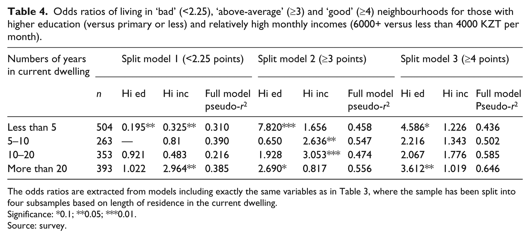
The odds ratios are extracted from models including exactly the same variables as in Table 3, where the sample has been split into four subsamples based on length of residence in the current dwelling.
Significance: *0.1; **0.05; ***0.01.
Source: survey.
First of all, split model 1 indicates, as one would expect, that both higher education and higher income strongly predict not living in ‘bad’ areas among the recent dwellers. However, it is also noteworthy that the longest-term residents with higher incomes also have almost three times the odds of living in such areas compared to the low-income reference group. This is certainly surprising, but upon deeper reflection it makes sense: unlike education, which usually remains constant after reaching ‘post-secondary’ adulthood, per capita household income is susceptible to changes in the demographic structure of the household. It is in other words probable that long-term residents’ household income might simply require being shared among fewer persons. The remaining coefficients, while expectably on the low side, are not statistically significant.
In split model 2 we observe that higher education strongly predicts living in ‘above-average’ neighbourhoods among the most recent and longest-term dwellers, whereas income takes over for those with 5–20 years of residence. In split model 3, which predicts living in high-prestige neighbourhoods, education ‘behaves’ similarly, albeit losing strength (and statistical significance) for the recent dwellers while gaining some for the most established population. In general, higher incomes seem to predict living in ‘good’ areas, but the coefficient is not statistically significant for any group.
The split model exercise allows the following tentative conclusions to be made: (1) the higher educated population was rewarded with better located housing during the Soviet epoch before the 1980s (and perhaps also after but the sample characteristics do not enable the achievement of statistical significance); (2) higher education also strongly predicts living in ‘above-average’ or ‘good’ areas; (3) persons with higher education and/or higher income shun the low-status neighbourhoods; and (4) those with higher incomes are more likely to live in ‘above-average’ (but not the best) neighbourhoods if the length of their residence is intermediate. That higher education alone, rather than income, would so strongly predict living in the better half of the city may seem inexplicable, but there is reason to launch at least one hypothesis. If, as this study has shown, the highly educated received better located apartments under socialism, then they would have been able to afford moving within the same types of areas after the demise of the socialist system after privatization (and therefore not during the early 1990s). In other words, socialist education-related advantages would simply carry into the post-socialist epoch via the privatization of better located (and probably better quality and/or more spacious) dwellings that can then be traded for comparable units within the same quality segment. After all, education alone does not go far in price-deregulated housing markets. It is money that sings (Ruble, 1995).
Conclusions
Cities are characterized by a spatialized internal social order, and the urban areas of the Former Soviet Union are no exception. Building on early post-Soviet evidence on the factors contributing to neighbourhood reputation in the post-socialist city, this paper has in fact also contributed to the debates on the socio-spatial idiosyncrasies of the demised socialist order. The contradictions and diseconomies embedded in the Soviet system manufactured a specific brand of socio-spatial distinction, reflecting the priority hierarchies built in the shortage-infested socialist planned economy. In this context, education and, particularly, area of employment appear to have been rewarded with prestigiously located housing. Accordingly, this study has found support for the notion that priority industries were in a better position to attract short-supplied labour by offering superior housing – at superior locations – as an important fringe benefit. This offers sound evidence in favour of the landscapes of priority interpretation of the socialist city’s structure and functioning (cf. Gentile and Sjöberg, 2006), while lending more general support to explanations that highlight the economic aspects of the socialist system in shaping urban patterns and processes (Bater, 1980; Domański, 1997; Lewis and Sternheimer, 1979; Shomina, 1992). Specifically, the results show that the Ul’ba Metallurgical Plant alone completely dominated the neighbourhoods that were commonly viewed as prestigious in the city, with the other metallurgical enterprises trailing in the mid-prestige category. Finally, the ‘other’ enterprises – the wood processing factory, the grain elevator and other low-priority actors of the urban economy – were strongly over-represented in the city’s ‘bad’ neighbourhoods.
In Ust’-Kamenogorsk, ethnicity and neighbourhood prestige did not seem to be strongly related at the time of the survey. Compared to the Russians, the members of the Kazakh titular ethnic group were under-represented in poorly reputed neighbourhoods and over-represented in the above-average (but not the best) neighbourhoods. This result contrasts with findings from elsewhere in the former USSR: in Estonia, for example, the Estonians were ‘underurbanized’ (Tammaru, 2001) as a result of the ethnic segmentation of the Soviet industrial labour market, which simultaneously shut them out of the housing stock that was under the control of ministerial subjects. However, Ust’-Kamenogorsk was one of Kazakhstan’s many closed cities, and it is likely that the Kazakh indigenous population was barred from urban living altogether, rather than to a particular segment of the housing stock alone (Gentile, 2004).
The data used in this paper present the situation as it was less than 10 years after the demise of the Soviet Union. In Sýkora and Bouzarovski’s (2012) conceptualization of post-socialist transition, this would approximately be the time when the first – institutional – transition stage started to give way to the second stage of transition, characterized by deep soci(et)al transformations. However, these changes remained framed within a fundamentally Soviet ‘homopolitan’ (Gentile et al., 2012) – that is, vastly homogenized – urban setting. The city’s streets, street names, buildings, markets, parks, neighbourhoods and other points of reference were little different from what they had been in the recent Soviet past. Therefore, the findings in this paper are equally relevant for the understanding of the geography of residential prestige under socialism as they are for the interpretation of the socio-spatial impacts of the early stages of transition. Above all, they constitute an additional indication that the effect of the introduction of market reforms has not had dramatic effects on the factors associated with neighbourhood reputation. Echoing the experiences of more centrally located post-socialist cities (Marcińczak, 2012; Marcińczak et al., 2013), by the early 2000s the Soviet legacies still determined the main features of the social geography of the post-socialist city. This has possibly changed by now, particularly in the light of the significant CEE construction boom of the 2000s, which has substantially altered the physical appearance, and perhaps also the social composition, of many cities in the region. Future research should address whether these conspicuous changes have also succeeded in transforming deeply rooted perceptions of the quality of the city’s increasingly diverse living environments.
Footnotes
Acknowledgements
The reviewers’ and editor’s comments are gratefully acknowledged.
Funding
The data collection for this work was funded by the Swedish Research Council for the Social Sciences and the Humanities (HSFR), project ‘the Post-socialist city in the XXI century’. The paper was partly written while the author was employed by Umeå University with funding in the form of a young scholar’s award (karriärbidrag).