
Abstract
Amidst complex social-ecological dynamics of localities and future uncertainties posed by global environmental challenges like climate change, there is a need of practicing the principles of learning and flexibility in public policy process. In this study we illustrate the importance of adaptive governance paradigm as an approach for bringing coherence between climate change adaptation and disaster risk reduction in India. We comment on the type and extent of integration between climate policy and disaster management in the evolving policy landscape of India and cite certain paradoxes in actual practice. We look towards Soft Systems Methodology (SSM) as a diagnostic tool for informing policy in place of the dominant donor–recipient models of knowledge generation and dissemination. In our diagnosis of urban and rural flooding in India, we found lack of transparency, coordination, local sensitivity and inclusivity in governance leading to a trust deficit among citizens and government institutions, compliance issues, struggle for change in power structures and access to more information while there is willingness for meaningful learning among different stakeholders given the opportunities for social learning. We suggest that pedagogy for ongoing capacity building programmes in India for climate policy and disaster management should incorporate such tools to enable an environment of social learning in consultations and facilitate cognitive abilities to comprehend knowledge from diverse sources. It is only through governance mechanisms for shared understanding which can usher the much desired fit between science, policy and practice.
Introduction
The development, understanding and knowledge build-up about physical science, impacts and mitigation of climate change have been progressively and comprehensively tracked by the Intergovernmental Panel on Climate Change (IPCC) since 1990s via its various assessments reports. It has been well established and concluded via these reports that the climate is changing and the impact of anthropogenic activities on the climate is unequivocal (IPCC, 2007). The change although at global level has its impacts felt at regional level that have constantly been researched and debated upon. Particularly over the Indian domain, significant warming trend has been observed in the past 100 years (Hingane et al., 1985; Kothawale et al., 2010). Various research papers and government reports (MoEF, 2010) have indicated an accelerated warming trend in the recent 30 years over most parts of India and although the profile of rainfall have been trendless on India wide scale, several regional trends have been reported and well researched (Guhathakurta and Rajeevan, 2008; Krishna Kumar et al., 2011; Pant and Kumar, 1997; Parthasarathy, 1994; Rupa Kumar et al., 1992). Along with an overall increase in extreme rainfall events and their intensities in the past 100 year period (Sen Roy and Balling, 2004), recent years have also seen an increase of frequency and intensity of heavy to very heavy rainfall events and a decline of low rainfall events (Goswami et al., 2006). Hence, there is ample scientific evidence that asserts the phenomena of climate change and growing extremes particularly over Indian context. A changing climate not only leads to changes in frequency, intensity, spatial extent, duration and timing of extreme climate events (IPCC, 2012) but also makes it challenging to forecast such events owing to inherent uncertainty of natural climate system and non-linear interactions amongst them.
Thus, there is an urgent need for integrating climate change adaptation with disaster risk reduction. While, there are differences in the approaches regarding their scope, genesis and mechanisms, a convergence of their objectives is sought due to need of knowledge regarding plausible alterations in the magnitude and frequency of future hazards, need to augment funding and political will in reducing disaster risks instead of relief and rehabilitation, need for their mainstreaming into ongoing development practices, need to focus on local vulnerabilities and tacit knowledge and the need to avoid duplication of planned activities and incorporate learning from ongoing practices (Mitchell et al., 2011).
Although, the approaches are finding convergence in international and national policy design, there have been challenges towards operationalizing such convergence. In this article, we first discuss the status of integration of DRR and CCA in policy and practice in India, need for capacity for adaptive governance and our intervention for assessing role of soft systems methodology (SSM) in providing a tool for such capacity development.
Integration of DRR and CCA in India—Near or Far
In order to gauze the extent and type of integration between DRR and CAA, we look into different levels of the governance system, that is, examples of key policies and institutions within national and sub-national levels and few examples from practice.
National Level: Glimpses of an Evolving Policy Landscape
In order to analyze the integration of DRR and CAA in the national policy level, we first look into the National Action plan for Climate Change (NAPCC) which came into existence in 2008. The approach of NAPCC as described in the document has been to usher a directional shift in the developmental pathway of India. It identifies eight national missions (National Mission for Sustainable Agriculture, National Mission for Enhanced Energy Efficiency, National Mission for a Green India, National Mission on Sustainable Habitat, National Mission on Strategic Knowledge for Climate Change, National Solar Mission and National Water Mission) to provide a policy framework for mitigation and adaptation actions in the country (NAPCC, 2008). The framework is designed to promote development objectives of the nation while offering co-benefits that respond to the global challenge of climate change (Byravan and Rajan, 2012).
It is noteworthy that disaster risk reduction does not find its space either as a core mission or in any of the existing eight missions of the plan document. Rather, it is bundled as disaster management response to extreme climate events with Green House Gas (GHG) mitigation in power generation, renewable energy technologies apart from solar, health and capacity building of the different levels of the government in a section of ‘other initiatives’. The scope laid out here encompasses development of forecasting tools for better prediction, vulnerability assessments for targeting interventions, collaboration with insurance providers, mainstreaming DRR into ongoing schemes, capacity development for integration of DRR in the level of financial institutions, project engineers and planners and augmenting communication through awareness generation and training of communities. We argue that by maintaining boundaries between DRR and missions targeting adaptation, there is a possibility of duplication of endeavours for knowledge generation as similar strategies for prediction and targeting are cited in core missions as well, it poses serious questions on coordination among implementing institutions and points to a lack of opportunity for learning from tools and practices of ongoing DRR activities.
While the climate policy planning seems to be ambiguous about the convergence of DRR and CAA, the disaster management policy landscape seems to evolving under the influence of past catastrophic disasters in the country. Every major action in the design of disaster management policy in India is observed to have followed a major disaster in the country. The High powered committee (HPC) formed to put national policy priority on disaster management came into existence after the aftermath of Odhisa cyclone of 1999 and another national committee after the Gujarat earthquake of 2001. The enactment of Disaster Management Act that created the institution of National Disaster Management Authority (NDMA) and its counterparts in sub-national level came after the aftermath of Tsunami of 2004. 1 The range of disasters under the scope of this institution has been cited as—Cyclone, Earthquake, Tsunami, Flood, Urban flood, Drought, Nuclear and radiological, Landslide and snow avalanches, Chemical (Industrial), Chemical (Terrorism) and Biological disasters and the function so far has been to build capacity for mainstreaming disaster management within government institutions, vulnerability and hazard mapping and awareness generation (NDMA, 2013).
Thus, it is evident that there is a growing policy emphasis on knowledge generation, capacity for mainstreaming and awareness generation in order to shift the approach of disaster management in India from being relief centric to preparedness and mitigation. However, there is a need for explicit linkages between the policy objectives of DRR and CCA in order to avoid duplication, better management of funds and learning across science, policy and practice.
Sub-national Level: How is it Trickling Down?
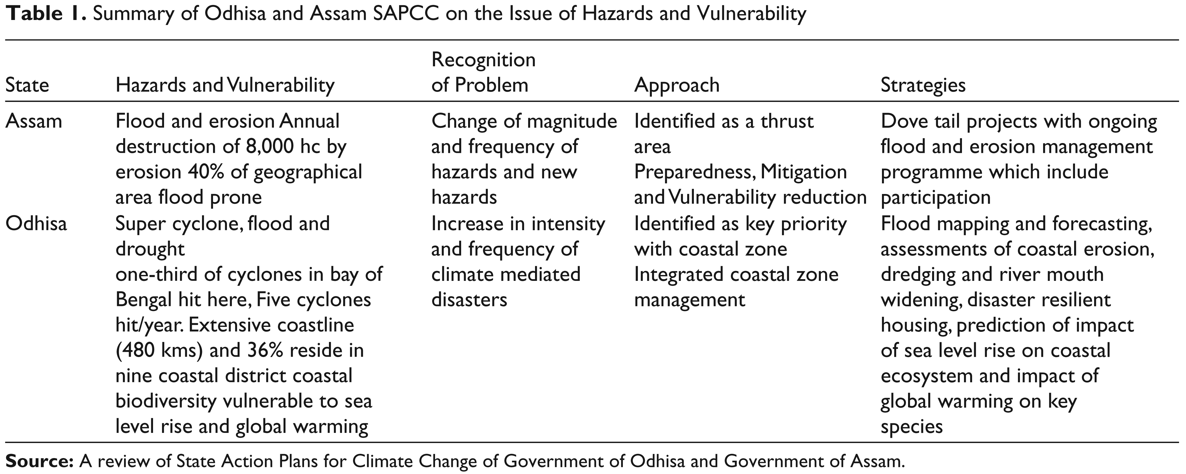
The sub-national level is important in the context of environmental federalism not just because of policy implementation, but also because of its ability to influence national policy and even serve as sites of innovation (TERI, 2011). In order to examine how the coherence of DRR and CCA is trickling down into the sub-national level of India, we scrutinized the State Action Plans for Climate Change (SAPCCs) of two most disaster prone states—Odhisa and Assam. Forty per cent of the state of Assam is flood prone and it suffers an annual destruction of 8,000 hc of land from erosion by the Brahmaputra River and its tributaries while Odhisa with its 480 km of coastline and 36 per cent of its population residing in nine of its coastal districts is hit by one-third of the cyclones in Bay of Bengal which comes to an average of five cyclones/year (Odhisa SAPCC and Assam draft SAPCC, 2011). Both the states recognize the risk of change of magnitude and frequency of the hazards and have put emphasis on disasters as a thrust area in case of Assam SAPCC and as a key priority area in Odhisa SAPCC. The approach taken for response in Assam SAPCC is three pronged—preparedness, mitigation and reduction while Odhisa aims for integrated coastal zone management. But when it comes to the actual strategies, it is mostly impact studies and dove tail projects of ongoing technological fixes which clearly indicates the need of capacity to tackle interdisciplinary issues of climate change (Table 1, see also TERI, 2011).
Although, State Disaster Management Agencies (SDMAs) along with their District Disaster Management Agencies (DDMAs) have been constituted and they find their roles mentioned in the SAPCCs, they face issues of fit, in terms of their functionality, with the exiting line departments of the government. Till now, they have been proactive in designing and delivering training programmes for enhancing adaptive capacities of communities and institutions along with hazard mapping to inform policy whereas the responsibilities of disaster relief and rehabilitation still lie with age-old state departments like revenue and disaster management. Such dichotomies raise questions for the scope of iterations between science, policy and practice and lead us to argue that the attempt towards preparedness for future hazards is following a very top-down expert-driven approach without much possibility of incorporation of tacit knowledge.
Summary of Odhisa and Assam SAPCC on the Issue of Hazards and Vulnerability
Paradoxes in Reality: Need for Adaptive Governance
From the national and state level climate change response and disaster management planning we can gauge that there is recognition of the risk of alterations in magnitude and frequency of hazards in the policy level. This leads to capacity needs like need of water storage capacity in drought prone areas of the country, need of preparedness for flash floods, need for augmentation in drainage capacity of storm water drains, management of services from wetlands, etc., some of which also finds its due place in policy documents. But in practice, the paradox is that there are instances of upstream dams diverting water from draught prone regions for utilization in industry and cash crop cultivation in drought prone states like Maharashtra (Dandekar, 2013), increase in flash flood incidences in flood prone states like Assam due to untimely release of water from upstream dams (draft Assam SAPCC, 2011) and in cities like Chennai, Bangalore, etc. (e.g., Gupta and Nair, 2011) there is not only encroachment but legal constructions choking drains and burying wetlands.
Thus, it can be inferred that there will be strong political economy influences on implementation of risk reduction and adaptation strategies in varying contexts within India. This calls for a diagnostic approach of contexts (Ostrom, 2007) to inform policy design apart from the ongoing top-down expert-driven approach. Thus, there is an urgent need to look towards the paradigm of adaptive governance which seeks to learn from diverse knowledge systems and experience, networking among various actors to facilitate social learning of novel solutions and leadership to navigate change in social-ecological processes (Folke et al., 2005). It has the potential of guiding planning processes which can produce strategies which are not only robust in design but also socially acceptable. However, the capacity to operationalize such a governance approach seems to be questionable not only in India but the entire South Asian region (Sud et al., forthcoming).
Adaptive governance approach calls for unambiguous policy objectives with institutions aware of the socialecological dynamics of a context and feedbacks from monitoring and evaluation of practices to policy, thus, incorporating learning and flexibility into the policy cycle (Pahl-Wostl, 2009; Rijke et al., 2012; Sud et al., forthcoming). However, in the entire South Asian region, there seems to be still a legacy of predict and control approach for policy planning and management. In climate change adaptation planning the trend in the region seems to be largely towards ambiguous climate change plan documents and emergence of de jure institutions for strengthening scientific base for informed decisions. Such institutions however, maintain levels of political jurisdiction as their functional scale, thus, raising questions of fit with issues of climate change that play out in an ecological scale. Moreover, in the practice level there seems to be a focus on DRR but a dearth of documentation has serious implication for learning to inform adaptive responses (Sud et al., forthcoming).
Problem Contexts
After a brief commentary on the evolving climate policy and disaster management landscape in India we provided the need of adaptive governance approach to bring convergence between DRR and CCA. In order to illustrate the above cited lack of regional capacity in learning and flexibility, we present two cases with varying development contexts in India—one of few villages in Lakhimpur District of Assam in northeast of India and another of Bangalore city in Karnataka in south of the country.
Villages of Dhokuakhana Circle in Lakhimpur District of Assam
The Lakhimpur District within Assam is situated in the north bank of the Brahmaputra River and, agroecologically a part of the Upper Brahmaputra Valley (Gajbhiye and Mandal, 2000). The district has two administrative sub-divisions—Dhokuakhana and North Lakhimpur. The population in the villages situated near the bank areas of Dhokuakhana is predominantly of Mishing tribe, a community which started their settlement from the north bank of Upper Brahmaputra Valley. The tribe has always experienced annual floods during the monsoon period and has been coping through special types of huts over tree stumps, boating skills, shifting livelihoods between agriculture, fishing and animal husbandry. After 1955, when the state government of Assam built an earthen embankment, called the Sissirkolghor-Tekeliphuta embankment, for flood control in the north bank, the Mishings could totally transform their forest covered habitat into a productive paddy cultivated agroecosystem. Dhokuakhana was referred in the 1970s as a success story of flood control through embankments, in Assam.
But since late 1990s issues of mismanagement of embankment maintenance and demands for relief packages from national government had been dominating the policy debate in Assam. Since the embankment breaches of 1998 in Sissirkolghor–Tekeliphuta, heavy crop area damage occurred due to floods in villages of Dhokuakahana; finally shifting a regime of productive paddy fields to one of sediment filled landscape. Let alone anticipation of such an abrupt regime change, the issue did not even appear much in public sphere, until recently due to academic interests on extreme events and political agitation (Assam Legislative Assembly Debates and newspaper articles, 1950–2012; Varma and Mishra, 2013; Varma and Mishra, submitted).
The increase of the sediment load of the Brahmaputra has been changing basin wide flow dynamics of the river. It has been flowing in a braided manner in the upstream and there is also a problem of aggradation of the river bed (Goswami, 2003; NHC, 2006; Sarma, 2005). The incision of one of the river channels towards the villages has been causing bank erosion (Varma and Mishra, 2013; Varma and Mishra, submitted). The coarse sand deposition is not a stand-alone occurrence in entire Upper Brahmaputra Valley, as similar events are also observed in upstream and downstream areas (ICIMOD, 2013). However, breaches near clusters of four villages (Matmora, Jangidangdhora, Arkepbaligaon and Borkhamon), in a 5 km radius of the embankment, occurred continuously from 2005 to 2008 though the High Flood Record did not peak after 1998 in this upstream region of the basin, indicating an inherent vulnerability of this locality. After 2010, the villages have been protected by a geo-textile revetment in the most vulnerable 5 km radius, though risks remain in upstream and downstream. But, the problem has shifted from flood inundation to a situation of landlessness and livelihood loss. On one hand, experiments with plantations and subsistence farming are being tried, while on the other hand, there has been an increase in political protests and even change of leadership. Till now, there is no analysis on the evolution of these diverse responses and their collective influence on recovery (Varma and Mishra, 2013; Varma and Mishra, submitted).
Bangalore City in Karnataka
Bangalore is not located on the banks of a river but frequently experiences flooding, leading to traffic disruptions, water logging of homes, loss of work days and increased risk of water-borne diseases (CED 2011; Gupta and Nair, 2011; Ramachandra and Mujumdar, 2009). In 2013, the city municipal corporation Bruhat Bangalore Mahanagara Palike (BBMP) identified 1,077 flood-prone areas in Bangalore (Mallikarjun, 2013). This urban flooding in Bangalore is the consequence of a combination of ecological and developmental changes in recent decades resulting in inadequate drainage capacity during rainfall events.
Bangalore city is located at an elevation of about 3,000 feet. In the sixteenth century, a cascading network of connected tanks was created to capture the rainwater flowing down into the surrounding valleys. These man-made lakes served the city by providing drinking water, managing storm overflow, recharging groundwater aquifers and supporting agriculture and fishing based livelihoods. In the twentieth century, however, Bangalore started pumping up its drinking water from a distance of 100 km from the Cauvery River. As Bangalore boomed to megacity status, the built up area expanded from 2 per cent in 1973 to 31 per cent in 2014 (TERI estimates). This came at the cost of vegetation cover which shrank from 47 per cent to 22 per cent over the same period. The catchment area of lakes was built up and the number of water bodies declined from 51 in 1973 (covering an area of 351 hectares) to only 17 in 2007 (covering an area of 87 hectares) (Ramachandra and Mujumdar, 2009). With the loss of these lakes, Bangalore has become dependent on a single source of drinking water, the Cauvery River, which is the subject of highly charged political conflicts with Tamil Nadu over water sharing. Another consequence of the construction over lake catchments is reduced groundwater recharge.
The natural drainage channels connecting tanks were used to construct major storm water drains, but these have been encroached and choked by the dumping of solid waste and debris and the inflow of sewage and industrial effluents. Population growth and urban sprawl have led the sewage treatment capacity being exceeded (Jamwal et al., 2014). The alignment of sewage pipes with drainage channels reduced the storm water drainage capacity. Moreover, the sewage and water distribution infrastructure has fallen into disrepair leading to incidents of leakage and contamination. The burial of natural streams, construction of covered drains and increase in impervious surface area has increased the runoff rate.
Urbanization also exacerbates urban flooding through another route: namely, the digging up of roads for construction of flyovers or underpasses and for laying utilities networks (water, electricity, telephone, etc). Hence, all these changes have combined to create the problem of urban flooding on the one hand and water stress on the other.
Our Tryst with SSM
In the earlier explained rural context of Assam an ecological crisis has occurred but formal responses appears to be functioning through a legacy of technological fixes ignoring linkages of such interventions with the social dynamics of the agroecosystem. While, in the urban planning of Bangalore, there seems to be an ignorance of the linkages across the ecosystem services which is making the city increasingly vulnerable to floods and scarcity of water. Such ignorance in management and planning often instigate discontent among resource users and non-inclusiveness of social issues may also lead to political struggle (Plummer, 2009) which is already seen in the autonomy movement for Mishing Autonomous Council (MAC) in Assam.
Adaptive governance recognizes systems thinking as a methodology for management of linkages across risks, impacts and responses. It seeks stakeholder participation in every level of policy making for a shared understanding of problem and vision for intervention (Pahl-Wostl, 2009; Rijke et al., 2012). Hence, we wanted to test the relevance of SSM in diagnosis of the problem contexts to delineate common challenges and opportunities for social learning, which is much sought for practicing adaptive governance. SSM utilizes systems thinking but acknowledges the plurality in human systems and differentiates between constructs of a system from the system itself. Hence, instead of modelling complex human-environment systems using a-priori criteria for selection of variables, the approach provides the opportunity for participatory modelling of different notions of a systemic problem. It finally aims for creation of a collective representation of the system and sets the stage for seeking solution through deliberation with stakeholders (Checkland, 1985; Checkland and Scholes, 1990).
Under an Asia Pacific Network for global change research (APN) funded project we held two workshops on systems thinking and adaptive governance in our research centres in Guwahati in Assam and Bangalore in Karnataka which used the aforementioned contexts as respective case studies. Although it was a capacity development project, the design had elements of exploratory research; we used group modelling among the participatory modelling techniques through which preliminary conceptual systems models were shared with different groups of stakeholders in each context and a step-wise process of iteration was followed (Vennix, 1996; Voinov and Bousquet, 2010).
The Guwahati Workshop
For this workshop, a study conducted by the first author regarding the issues of villages of Dhokuakahana circle of Lakhimpur district was drawn to construct the preliminary models. The study inferred that there are four narratives
2
surrounding the problem of flood, erosion and sediment deposition by four distinct stakeholder groups (Varma and Mishra, 2013; Varma and Mishra, submitted), that is,
‘We are doing it right’—the narrative from the Water Resources Department (WRD), Government of Assam, demonstrates the confidence in the annual maintenance of the existing earthen embankment, infrastructure to control lateral migration of river and the new intervention with geo-textile revetment for 5 km radius, surrounding four most vulnerable villages, for bank protection from erosion. Besides, issues in implementation like delay in allocation of necessary fund inhibiting timely maintenance, weakening of the earthen structure due to human settlements and even intentional damages by the villagers form part of the narrative. ‘We are neglected’—the narrative from the Mishing villagers and political activists among them, demonstrates the discontent among the tribe regarding the ongoing intervention. The issue is no longer of flood hazard, especially of the villages protected by the geo-textile revetment, but it has changed to landlessness, poverty and migration. The household income of Mishings started dwindling as flood control interventions started failing. The extent of rice cultivation decreased due to damage to their crop area as a result of loss of land, first due to erosion and then due to acquisition of land during maintenance of the embankment as it had to be constructed away from the river and further towards the villages. Finally, coarse sediment deposition occurred after recession of flood waters, in different patches, first in 1998 and then from 2005, drastically decreasing the crop area. The decrease in household income, together with dearth of land for settlement has been driving migration from these villages. Simultaneously, continuous inundation of villages and again the scarcity of land have prompted a set of households to settle over embankment. An irregularity in payment for compensation of land loss has also contributed for maintaining these settlements. The annual maintenance of the embankment is not only important for flood control but also had implication for the household economy, as it involved local labour and created opportunity for subsistence farming in excavated areas. The delay in embankment maintenance raises questions on the effectiveness of this intervention and together with irregularity in compensation of land loss instigates protests by villagers during the time of maintenance. The involvement of contractors leading to compromise in quality of materials and use of labour outside the villages adds fuel to the protests further delaying maintenance. ‘Villagers are the problem’—the narrative from the employees of various extension offices of the departments of Government of Assam which points to the trust deficit in the context. The flood relief not only provides subsistence for farm families but also a reason to maintain settlements over embankment to justify their claim. Although land is provided elsewhere for resettlement, there is inhibition to move away from the river bank driven primarily by the lifestyle of the riparian tribe but also due to being relief dependent as well as the new found hope of compensated for land loss. However, Mishing settlements are largely in government land as the banks of the Brahmaputra and its tributaries were used to be forests before being transformed into a paddy cultivated agro-ecosystem. As a result there are sparse individual land holdings among the tribal villagers reducing the chances of being compensated for land loss. ‘Problem is not here’—the narrative from local academicians who pointed out that the problem is not fixed to villages of Dhokuakhana and from 1998 onwards but rather spans beyond this spatial and temporal scale. Flood played a very crucial role in shaping the lifestyle of the Mishings. The availability of land in the banks of the Brahmaputra encouraged the Mishing settlers, till early twentieth century, for continuation of their hill dwelling culture. The practice of shifting cultivation of summer rice, facilitated by the annual flood regime also maintained this culture. But, with population rise there was a decline in availability of land and also triggering of commodification of rice. Such prospects of income along with growing influence of settled agriculturists of the plains led to permanent cultivation of transplanted variety of rice. However, this could not have been so prosperous without the intervention of flood control through embankments, which was an immediate response after the change of river courses following the 1950 earthquake in Assam. Again, the influence of settled agriculturists would not have been so pervasive to initiate a process of acculturation if the Mishings did not have an inherent ability to network and learn. But the prior nomadic lifestyle of the Mishings inhibited them from permanent ownership of land and built a tendency to occupy revenue free land. Thus, after the decrease in availability of land, more so after erosion process of the late 1990s, such a tendency facilitated some of their settlements over embankment.
These four narratives were captured through conceptual systems modelling using causal loop diagrams (Sterman, 2000) and were used as preliminary models. In the workshop, stakeholders were invited from Lakhimpur district and Guwahati representing each of the narratives. The narratives were not shown to the participants but they were grouped according to the four narratives, that is,
Group WRD—This constituted employees of the Chief Engineers Office, WRD in Guwahati and were provided with the model of the first narrative. Group Civil Society—This constituted members of local non-government organizations working in the villages of Dhokuakhana and Mishing student activists and were provided with the model of the second narrative. Group Revenue and Disaster Management—This constituted employees of extension offices within Lakhimpur district of Revenue and disaster management department of the government of Assam and Lakhimpur district disaster management authority under the Assam Disaster Management Authority (ASDMA). The group was provided with the model of the third narrative. Group Academia—This constituted doctoral candidates from Indian Institute of Technology (IIT), Guwahati from both humanities as well as civil engineering departments and also faculty member from government college of Lakhimpur. The group was given the model of the fourth narrative
Following steps were followed in the course of four days to facilitate learning within and among the groups—
Step 1: The participants were exposed to elements comprising the narratives but in the larger context of the entire Brahmaputra basin through lectures by resource persons. Following a brief introduction to systems thinking and the concepts of narratives and discourse, the four groups were formed and a discussion among the group members was encouraged to understand, modify the preliminary conceptual models and think about suitable interventions. After a round of modification in the models, a plenary was arranged where a group representative presented the modified model along with an intervention and its justification. The plenary was followed by a question and answer session among the groups regarding facts and reasoning of the causation chains and feedbacks in each others’ models. Step 2: A lecture on uncertainty and climate change risk followed after the question and answer session of Step 1. Then the groups resumed and were encouraged to reflect on the discussions after the plenary and also on future risks and uncertainty. Once again the process of plenary was followed and opportunity was given for new questions and clarifications.
A transcript of the recordings was prepared and shared with the participants and their feedback was invited.
The Bangalore Workshop
In this case, we conducted a literature survey and semi-structured interviews with stakeholders of government departments like Bangalore Development Authority (BDA), Lake Development Authority (LDA) and Bangalore Water Supply and Sewerage Board (BWSSB) and also think tanks like Ashoka Trust for Research in Ecology and Environment (ATREE) and Environmental Management and Policy Research Institute (EMPRI). Here, we found that capacities were different than in the context of Lakhimpur, stakeholders had an impression of the complex linkages and need of holistic understanding but instead of a coordinated response the practice was more of fault finding among institutions or citizen behaviour.
Here, the preliminary models were according to three interlinked issues, elements of which are identified in earlier research and also validated in our interviews—
Storm water and sewerage—There is construction of sewerage system according to the topography of Bangalore so that the sewerage is along the natural gradient. But this practice has led to location of sewer pipes along storm water drainage systems which has led to obstruction to storm water drainage. There is a need for maintenance and supervision of the sewerage system which requires construction of man holes. But the location of the sewer pipes has prompted the construction of man holes again along the drains leading to more obstruction to drainage. The population increase in Bangalore has led to increase in waste water generation which decreases the performance of waste water treatment plants as it is beyond the capacity of these plants. As a result there is inclusion of solid waste in sewerage. At the same time encroachment of sewers has decreased the opportunity of maintenance and supervision which in turn has led to increase in incidences of leakage of sewage into storm water drains. Therefore, solid waste from sewerage is increasingly getting dumped into storm water drains leading to siltation of drains. Moreover, the obstruction to drainage from sewers and encroachment on waterways is leading to erosion of banks and bed. Such erosion also increases siltation of drains. Finally, the capacity of drainage is getting decreased due to such siltation and obstructions leading to floods as surface run off increases during rainfall events. While rainfall also decreases the performance of waste water treatment plants, the surface runoff is also increasing due to increase in imperviousness of the surface. Urbanization and land use—Urbanization in Bangalore has led to increase in urban sprawls. This has further led to increase in built-up area increasing imperviousness of surface and decrease in evapotranspiration as a result of decrease in vegetation cover decrease. Urban sprawls have also led to encroachment and filling in of floodplains and most of such periphery areas are not well serviced by the utilities. As result, there is dumping of solid waste in storm water drains which is also a general practice during construction for extending the urbanized areas. Now, the increasing imperviousness and decreasing evapotranspiration is increasing the surface runoff during rainfall events while the encroachment and solid waste is increasing the obstruction to drainage. Thus, an increased runoff and drainage obstruction will obviously lead to flood events. At the same time, the lakes which performed a service of storage of excess waters are also decreasing in number and size due to increase in built up area. The decrease in this service increases flood directly as well as indirectly, as it leads to erosion in downstream water ways leading to siltation and further causing obstruction to drainage. The decrease in storage of excess waters along with imperviousness of surfaces is also leading to decrease in groundwater recharge contributing to issue of water stress. Demand for public services and infrastructure development—The growth of urbanization has increased the demand on public services like water, electricity, transport, etc. This has led to massive infrastructure development; one of such examples is road widening, construction of underpasses and flyovers for mobility. This together with the increasing purchasing capacity has increased traffic congestion which again driving more demand for public services. During the process of such infrastructure development, it has led to damages in underground pipes due to the ignorance of pipeline layout. Such damages obviously contribute to water stress problem, which is as it is increasing due to groundwater depletion and reduction in number and size of lakes, again increasing the demand on public services. Again, the infrastructure development has led to digging of holes for utilities network which have led to water logging as the tasks seldom follow timely completion. Such water logging incidents further lead to flood disaster response as they aggravate with choking of storm water drains during rainfall events, again creating demand on public services for relief.
These three issues were presented as preliminary conceptual systems models again using causal loop diagrams. Participants included representatives of the Bangalore Metropolitan Region Development Authority (BMRDA), BWSSB, Central Ground Water Board (CGWB), EMPRI, LDA, Administrative Training Institute (ATI) and State Institute for Urban Development (SIUD), Mysore, in addition to research and academic institutions ATREE, Indian Institute of Science (IISc), Indian Institute for Human Settlements (IIHS) and Azim Premji University; and civil society organizations like Environment Support Group (ESG). The same steps like in Guwahati were followed but here participants were allowed to pick and choose the issues for formation of three groups.
Step 1: Lectures on inter-linkages of lake ecosystem, urbanization and peri-urban issues were conducted which touched upon the three interlinked issues for group activities. This was followed by modification of the models and a plenary to identify linkages within the issues and facilitate new questions and points of clarification.
Step 2: As Guwahati workshop, further iterations were encouraged after the plenary and a lecture on uncertainty and climate change.
A transcript of the recordings was prepared and shared with the participants and their feedback was invited.
Common Issues of Varying Contexts
A coding exercise of the transcripts of both workshops helped us to identify some common themes across the different contexts.
Different Government Institutions Responsible for Different Dimensions of the Problem without Coordination and Transparency
Guwahati—The state WRD is responsible for control of floods and is increasingly moving towards bank protection, though they are struggling with cost and allocation of funds owing to a long process of making estimates, submission and approval from Central Water Commission and management of the fund across a number of their sub-divisions. The Revenue and disaster management department provides relief and rehabilitation if the flood protection infrastructure fails. The WRD also gives an estimate of land to be acquired for construction/reconstruction of embankment to the Revenue and disaster management which is also entrusted with distribution of compensation for such acquisition. However, the extension offices of the Revenue and disaster management department are not consulted in making guidelines for acquisition of new land and there is yet no provision for compensation of land loss due to erosion, as it is not regarded as a disaster by the NDMA.
Bangalore—Lake management is divided among the BDA, the BBMP and the LDA. While the BBMP is responsible for maintaining storm water drains, the sewage lines are the responsibility of the BWSSB. In planning new layouts, the BDA does not refer to the BBMP’s drainage map. As a result, plotted developments may legally come up on lake beds or drainage channels.
Ignorance, Motivation, Trust and Rules
Guwahati—There is ignorance of formal rules like requirements of bank accounts among the student activists, which was also observed among many villagers during fieldwork in the area by the first author. As a result of lack of bank accounts, cheques for flood relief or compensation of land acquisition is not collected. The issue of erosion not being recognized as a disaster came as news for the activists and many members of the academia group which raises serious questions for the hope of compensation among villagers. Similarly, the formal rules are being framed without much sensitivity to the customs or convenience of the tribal population. For instance, one of the major reasons why the Mishings do not come forward for conversion of government land to individual land holding is because the land allotted to each farm family by the government does not suffice their joint families and they would rather continue on with their settlements though they are aware of being framed as encroachers. Such ignorance has given rise to a trust deficit in the context wherein there is doubt over government intentions of spending huge sums in river bank protection while farmers are landless, motives of foreign consultants and also blaming of villagers for intentional damage.
Bangalore—There are gaps in enforcing compliance to existing rules. At the individual level, this may be due to ignorance or motivation, for example for segregating waste at source or rainwater harvesting. But there are also systematic violations and circumventing of rules by powerful interest groups like the real estate industry. There are instances of apartment complexes built on lake beds and major drainage channels in violation of buffer zone norms, of declaring agricultural or common pasture land as barren and hence, eligible for conversion of land use, or of planting eucalyptus to drain the lake and then convert it for real estate developments which is also cited in Ramachandra et al., (2013), Nadgir (2013) and Navya (2013). Moreover, one of the participants in the workshop pointed out, even illegal constructions built over a storm water drain can be regularized by paying a fine under the Akrama-Sakrama rules (Karnataka Town and Country Planning [Regularization of Unauthorized Development or Construction] Rules 2013). This again builds mistrust in the context and instigates finger pointing while taking action.
Exclusion and Transformation
Guwahati—The discontent of exclusion of community needs in disaster management has facilitated mobilization of Mishings from victimhood to occupy political space. Villagers have been organized for a political struggle for autonomy within the Assam state and now they seek empowerment for issues like flood and erosion control of areas under the re-constituted MAC. They no longer trust the executive of the state and seek power for management of funds allocated for their region.
Bangalore—There is spatial and social inequity in access to drinking water supply or proximity to waste water release. In planning urban development, peri-urban actors tend to be excluded even though they are directly affected by such decisions (Lele et al., 2013; Mehta et al., 2013; Narain, 2009). Finally, ecological considerations are yet to be incorporated into urban planning and there is need for a zoning exercise with a trans-disciplinary approach. There is a need to understand the topography and the presence of first and second order streams to prevent encroachment of lake beds or drainage channels. There is increasing demand on government institutions for information to be made public by academia and civil society.
Although climate change projections for India show an increase in rainfall intensity interspersed by dry spells, uncertainty and future risks failed to make an impact in the collective mindset in both the contexts.
Conclusion
The complexity of multiple drivers of place-based vulnerabilities to climate change along with the lack of preciseness of climate related risks at the local level creates an uncertainty on the type and degree of its impacts. There is an undeniable need of guidance of science for better quality of policy intervention, but equally important are the lessons from practice for its acceptability in social-ecological contexts. In the midst of dynamics of present complexity and future uncertainty, there is a need of creating a better fit between science, policy and practice by introducing principles of learning and flexibility in public policy process.
In our study, it is seen that lack of transparency, coordination, local sensitivity and inclusivity in governance leads to a trust deficit among citizens and government institutions, compliance issues, struggle for change in power structures and mobilization to seek access to information. However, there is willingness for meaningful learning in both the contexts as innovative solutions of water pricing and regulatory framework for subsistence farming in newly emerged land came up during the iterative process of group modelling in the Bangalore and Guwahati workshop respectively. This illustrates the need of forums for social learning in policy processes where solutions derived through deliberations can feed into design of long-term adaptation strategies, a finding also mentioned by Paschen and Ison (2014). The NDMA can incorporate such tools in their pedagogies of ongoing capacity development in different levels of political jurisdiction which can usher the much sought after learning and flexibility for converging DRR and CCA. Lessons from such forums in India can feed into the SAARC Disaster Management Centre housed in the National Institute of Disaster Management (NIDM) which has the mandate for integrating DRR and CCA across the countries in South Asia.
Footnotes
Acknowledgements
We are thankful to all the government officials, students, researchers and employees of Non Government organizations for giving their time and insights in the workshops. We are grateful to Asia Pacific Network for Global Change Research (APN) for the support given to conduct the workshops.