



Abstract
The current study aims to contextualise cohousing with a focus on analysing a traditional rural settlement in Iran. Azghad is a historical village located in Iran, which has been developed throughout centuries based on strong social and environmental systems. The research uses field studies in the form of observing the environment of Azghad village, initial and natural explanation of housing pattern and interviews with local people with a qualitative research approach and documentary studies examines the physical characteristics of this rural community. Through investigating the physical pattern of the village in the area under study, the elements of the social–physical system which form the residential type of the village were extracted. The comparison of the social and physical system of the residential fabric of the Azghad and its residential neighbourhoods showed that the residential pattern of Azghad could be introduced as an example of a collective housing model. The rural housing type is an example of a collective housing style that has been formed over time based on the shared values of residents and the activities they wanted to do collectively.
Introduction
Settlement refers to a place where people concentrate and settle down for living and production purposes. It can also be called a residential settlement. According to characteristics and sizes, residential settlements can be classified into two categories: urban settlements and rural settlements. (Zhou et al. 2013, pp. 515–20). Research on rural settlement geography began in the 19th century. Kohl, as the originator of rural settlement research, systematically discussed the relationship between settlement location and population concentration in his book The Relationship between Human Traffic and Terrain in 1841 (Ma et al. 2017, p. 2). Since then, many researchers have begun to explore the relationship between settlements and environment. From the 1920s to the 1960s, there was more and more research on rural settlements. Demangeon (1939) in France and Doxiadis (1968) in Greece qualitatively analysed the formation, development, type and function of rural settlements. After the 1960s, the metrology concept was introduced in rural settlement research which then entered a qualitative and quantitative stage. ‘Rural Settlement in an Urban World’ (Bunce 1986, pp. 171–2), Rural Settlement and Land Use (Chisholm 1962, pp. 1–17) and ‘Determination of Settlement Patterns in Rapidly Growing Rural Areas’ (Goodwin, Doeksen and Oehrtman 1984, pp. 67–80) were such examples. Since 2000, researches has been focused on spatial layout and influencing factors (Banski and Wesolowska 2010, pp. 116–126) their spatial form and type (Han et al. 2017, pp. 1–12), the evolution and reconstruction of rural settlement patterns (Mao et al. 2017, pp. 1–17; Porta et al. 2013, pp. 12–26), land use and landscape ecology (Vásquez and Hormazabal-Poblete 2016, pp. 534–45) and the social perspective (Rufalco-Moutinho et al. 2016, pp. 243–50).
There is a paucity of research, linking physical environment variables to specific forms of social interaction or community (Abu-Ghazzeh 1999, p. 2). Mashhad has experienced unprecedented rapid urbanisation expansion, with an increase of over 250, 215 from 2011 to 2016 (Statistical Centre of Iran n.d., pp. 127–77). The multiple dualities in the social–spatial dimension of villages in semi-urbanised suburbs of Mashhad city have emerged during Iran’s rapid urbanisation since the early 2000s due to interregional migration (Motlaq and Abbaszade 2012, pp. 89–91). One aspect of these dual characteristics is derived from the residential space segregation between urban migrants and established rural residents that are divided into houses in single-family occupancy in suburban area and houses in multiple-family occupancy in the rural area of Mashhad. There are alternate forms of suburbia based on new urbanism, one idea is to look at these alternate models, including the cohousing community in Mashhad City. Insight into alternative residential developments can be crucial in efforts to change environmentally damaging low-density, large-lot, and automobile-dependent residential patterns (Göçmen 2014, pp. 1220).
Suburban places could model themselves on cohousing (Hagbert et al. 2019, pp. 30–2) and look to rural settlement to pay attention to the decisions that have been made over the decades to zoning rural residential space. This micro-study focuses on investing the spatial and physical aspects of the neighbourhood association, both as the structure of relationships and representation of ties between people.
There has been nothing to do with freezing architecture in its traditional form, but rather consists of basing projects on spatial analyses aimed at interpreting and conceiving new functional roles within contemporary agriculture and countryside (Tassinari et al. 2013, pp. 731). Our approach is based on a concept rooted in the tradition of agricultural settlements and pays attention to preserving and rediscovering consistency in terms of relations among signs and patterns. Finding that connection is based on the underlying rules which created those structures, rather than to mere protection or restoration of historical signs and formal solutions (Tassinari et al. 2013, pp. 730).
The current study aims to extract the original pattern of the residential type of the historical village of Azghad located in Khorasan Razavi Province, Iran, which has been developed throughout centuries based on active social and environmental systems, according to the residential type with the cohousing model. Considering the role of population and living condition of people in rural settlements’ morphology, the central question of the study is:
RQ: How have social factors influenced the physical system and contributed to the formation of cohousing pattern in the area under study?
Review of the Related Literature
Recreating Villages in the City
Compared to the number of studies of urban residential segregation (Wu et al. 2014, pp. 110–17) and classical topics of rural studies, the multiple dualities in the socio-spatial dimensions of villages in semi-urbanised suburbs of large cities have seldom been considered. A form of semi-urbanisation has emerged in these rural communities within an affordable commuting boundary around large cities and in big-city suburbs, there has been a noticeable increase in residential segregation in these semi urbanised villages (Wu et al. 2016, pp. 660–2). Residents with differentiated careers reshaping the suburban rural community into a fragmented semi-urbanised society (Wu et al. 2016, pp. 660–2) and suburban ‘sprawl’ has been blamed for contributing to the breakdown of social institutions (Beske 2007, p. 39).
Originating in the reform era, houses for single-family occupancy are being gradually or partially replaced with those for multiple-family occupancy to accommodate the immigrants (Ward 2015, pp. 100–5). The cohousing movement is an example of a reaction against this pattern, seeking to counter alienation by adopting design strategies at various scales that promote community identity and interaction and provide access to nature (Sanguinetti 2014, pp. 90–6).
The cohousing movement is considered as a model to make life more social and greener in a rural–urban context (Hagbert et al. 2019, pp. 27–30). Cohousing communities are neighbourhood developments that creatively mix private and shared dwellings to recreate a sense of community, while preserving a high degree of individual privacy. Cohousing is chosen by many because it provides an answer to the rise of hyper-individualism and the breakdown of community, which we mentioned above (Lietaert 2010, pp. 576–80). The important thing and the idea with this building were to create a village-like community where residents know their neighbours, where they have the security of having relations, some social capital if they wish.
Research on rural settlement’s spatial patterns and their evolution help to reveal the interaction between humans and land in different development stages and different areas (Jiang et al. 2015, pp. 265–73). Rural studies have highlighted rural idylls as something which rural inhabitants and ‘armchair urban residents’ (Bunce 1994, pp. 21–35) aspire to, perhaps as a vision of an excellent place to live or as a repository of values. Such rural idylls are now recognised amongst academics as normative and power-infused, insofar as they seek to construct rurality in specific ways. Such constructions are spatially and historically contingent (Shucksmith 2018, pp. 170–2). Thus, rural idylls are seen as both prevalent and necessary, though understood as a method rather than as a goal in cohousing. It provides a theoretical basis for rational land use planning. Therefore, attributes of rural settlements themselves, namely their displayed morphology, can be used to replace the commonly used index for the zoning of settlements (Jiang et al. 2015, pp. 266–70).
Cohousing
To start with, it is essential to stress that the cohousing model did not arise by magic. Instead, it can be described as a grassroots and innovative answer to particular problems that many citizens are increasingly facing, mainly in northern and western society. Cohousing has helped people to recreate village-like communities in impersonal urban contexts. As expressed by Lietaert ‘as a model to make life more social and greener in an urban context’ (Lietaert 2010, pp. 579–80). One of the main goals of cohousing is to fulfil the desire of residents to live in a socially supportive context (Marcus 2000, pp. 150–60). It attempts to overcome the estrangement of modern subdivisions in which people do not know their neighbours and lack a shared sense of community. Cohousing can be defined as ‘a private initiative to build neighbourhoods with active resident participation in all stages and with parallel goals of fostering environmental stewardship and social cohesion at the domestic level’ (Torres-Antonini 2001, p. 11).
The widely used North American term ‘cohousing’ usually refers to Danish bofaellesskab, means literally ‘living community’ and it was designed for two primary purposes: to increase the quality of cohousers’ social life and to lessen the burden of everyday life, while increasing free-time at home (Lietaert 2010, pp. 576–80) and Swedish kollektivhus. Instead of ‘collective housing’, Fromm uses the term ‘collaborative communities’, which itself includes subcategories such as ‘cohousing’, ‘central living’ and ‘housing with shared facilities’ (Fromm 1993, pp. 95–7).
The focus of the discussions in cohousing often lies on the ways of living, as well as on the built environment. In order to understand the relationship between these two factors, one has to use clearly defined concepts. In English, housing may refer to the building itself, but the term may also be used to refer to a social content or a process leading to the establishment of physical structures. On the other hand, communal living or collaborative lifestyle can be used to denote the social content. When the focus is on the role of the physical structures, one may use the concept cohousing project (including both imagined and implemented projects), or collaborative residential building (Vestbro and Horelli 2012, pp. 325–35).
Cohousing combines the autonomy of private dwellings with the advantages of community life. It has private units, semi-private space, and indoor and outdoor communal spaces. Residents maintain and manage indoor and outdoor communal spaces and organise regular social activities within the communal spaces. Regular activities encourage more significant social interaction and help to form stronger social networks. These activities and spaces are often open to the wider community to encourage greater integration and community development across a wider area, unlike gated communities where residents from the wider community area are excluded.
Therefore, enhanced connection to one’s cohousing community likely results from practices that promote close relationships, regular social contact and perspective-taking among neighbours (Sanguinetti 2014, pp. 86–90). Cohousing is a residential development intended to enhance residents’ connection to others and nature, and a systematic study of the typology of cohousing practices to promote connection has been necessary. As mentioned by Hagbert et al. (2019, pp. 27–32), cohousing must be understood contextually, as an alternative to the contemporary market-driven consumer-oriented housing provision that otherwise characterises urban development.
The Principles of Social Contact Design in Cohousing
Social contacts in a community are enhanced when residents find the opportunities for contact, live in close to others and have the appropriate space for having interaction (Williams 2006, p. 197). ‘These social contact design principles comprise a series of features thought to foster propinquity among neighbors’ (Torres-Antonini 2001, p. 13). There is recurrent reference to the principles of social contact design and their importance to cohousing (McCamant et al. 1994, pp. 1–16) and to sustaining a sense of community among its members (Torres-Antonini 2001, p. 32).
This emphasis is since the physical environment is designed for sustainability and social contact. The process is based on active resident participation, which in turn leads to community self-governance (Fromm 1993, pp. 92–5; Hasell and Scanzoni 2000, pp. 140–5; Marcus 2000, pp. 146–63; McCamant et al. 1994, pp. 1–16; Torres-Antonini 2001, p. 13). The result is a community model where the lifestyle aspirations of the residents seem to fit tightly with the shape of their built environment. In consequence, the design is a critical factor in cohousing (Torres-Antonini 2001, p. 13).
The social contact design principles adopted in cohousing, (Fromm 1993, pp. 92–7; McCamant et al. 1994, pp. 1–16; Williams 2006, pp. 197–200) include:
(1) The provision of indoor and outdoor communal facilities: shared open spaces—common house; (2) Increased building density; (3) surveillance opportunities: good visibility into all communal spaces; (4) The division of space; (5) gradual transitions between public and private space; (6) provision of semi-private outdoor spaces close to private units for socialising; (7) positioning of key facilities and access points on shared walkways; (8) circulatory system: emphasised pedestrian circulation; (9) the tendency for private dwellings to be of smaller than average unit size; (10) extensive common facilities: loss of space in the private unit supported by the provision of communal spaces, for example communal kitchen/dining areas, laundry, workshop, garden and storage space, grouped spaces and structures; (11) functionally and symbolically equivalent to a village’s civic centre, are mentioned as its most prominent features.
It would be reasonable to focus on the spatial pattern of neighbouring units in the village which may enhance connections between local people. In the following sections of this article, the principles of social contact design would be discussed based on the physical context of Azghad and compared with the social contact design principles in cohousing models.
Method
Data has been collected through observation and simultaneous interviews, photography, and mapping of residential units and neighbourhoods. we proposed a model based on the spatial association between social relationships and zoning decisions. The indices of rural social patterns were used to analyse the differentiation of structural composition, spatial arrangement and characteristics of Azghad settlement. Detection of the spatial hotspot was used to determine the combination of residential spaces and the number of rural neighbourhoods. Using participatory by interview and field study method, we interviewed households living in 70 neighbourhood patterns, to determine the social life of the villagers and factors influencing the evolution of rural neighbourhoods.
Present Study
According to the literature on environmental designing, environments should be evaluated based on the degree to which they provide the opportunity for the establishment of relationships among the residents. However, an important point in such studies is taking into account the area under study.
Azghad is a village located at a 25km distance from the southwest of Mashhad, the centre of Khorasan Razavi Province, Iran. Figure 1 depicts the geographical coordinates of this village. Its longitude is 59°20′, its latitude is 36°12′, and it is located at 1680 meters above sea level. The definition of connection to the community at Azghad incorporates a sense of connection to the physical settlement that promotes connection. As Sanguinetti (2014, pp. 90–6) pointed out, development of rural spatial pattern take place through the everyday lived experience of residents. Therefore, the main aim of such investigations is to determine the spatial structure of buildings and in fact, how these connections may be enhanced by the spatial pattern of the village.
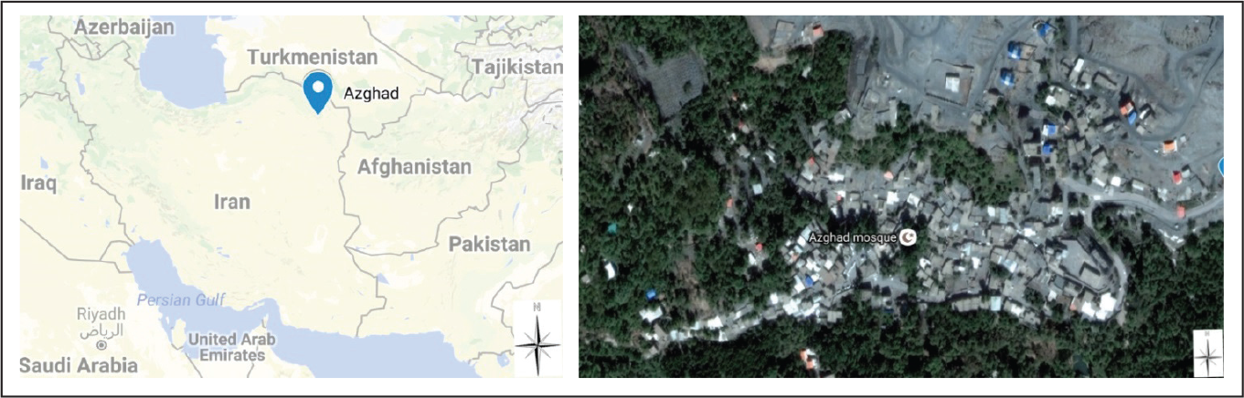
Based on the spatial pattern and the use of the built space, it seems that the social system of the Azghad has been the basis for the emergence of a participatory and collective lifestyle, which has, in turn, influenced the spatial system. We continue to study the pattern of the village neighbourhood units based on the principles of designing neighbourhoods in cohousing models.
Location of Neighbourhoods in the Village
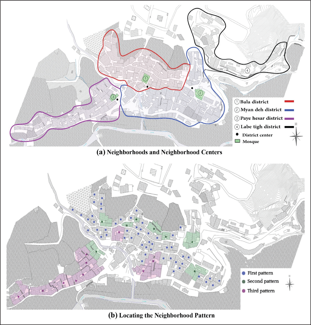
Azghad has been divided into four districts (Figure 2a). Bala neighbourhood is the biggest and oldest of the village’s districts located at the northern part of the village. The historical mosque which is located at the southern part of the Bala neighbourhood imposes a huge centrality on neighbourhoods as the main gathering spot of the villagers and service centres (Khan-Mohammadi 2005, pp. 92–5). In the other two districts, mosque also act as the centre but in lower scale, while in Labe-tigh, considered as the new context of the village, there is no gathering centre. Districts have emerged due to the gradual extension of the village during the development stages and ethnicity did not have a role in the creation of these areas (Majidi and Vahedian 2008, pp. 93–4). The pattern of neighbourhoods in the village follows the three general typologies, which further explores these patterns. As shown in (Figure 2b), in order to recognise these patterns, attempts have been made to sample neighbourhoods from different parts of the village. Of course, it is essential to note that the newest village context does not follow these patterns due to the development stages of the village.
The Combination of Residential Spaces
One of the important issues in the residential context of this village is the integration and density of houses which has an organic, compact context. Most buildings have been built in two floors and they are privately owned. The first floors are usually residential and the lower floors are usually allocated to a warehouse and for keeping livestock. These buildings are merely formed for human beings and space has been broken down based on the everyday needs of the residents (Khan-Mohammadi 2005, pp. 95–105). The inner space of these buildings often has a hall and many rooms, while the kitchen, restroom and storehouse for keeping culinary items and animal feed are often located in the yard.
In Azghad, each neighbourhood unit is a local area with specific borders and social networks. These units have unique physical and social features in a way that their borders are easily distinguishable. There is a particular harmony in the type of houses, the form of buildings, the organisation of spaces, the hierarchy of areas with population density, the type of residents’ activities and interpersonal relationships. Inside the area of neighbourhood units, people conduct shared social activities and have close relationships with each other. This refers to the spatial arrangement of a neighbourhood supported by Newman’s ‘defensible theory’ (Newman 1972, pp. 35–8). According to this theory, territoriality is a critical mechanism for creating a cohesive residential environment, making it well contained and easier to monitor and control. Neighbouring can be engendered by having a small-scale, well-defined neighbourhood with clear boundaries.
In the following sections, the physical aspects of the neighbours’ participation which regulate the relationships and exterior manifestations of cooperation and interactions among the residents would be discussed.
The First Pattern (Kinship Units)
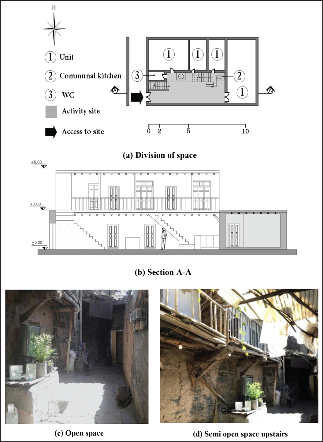
In this pattern, one or two-floor houses are arranged around the open space in the form of an ‘L’ and enter the semi-private area of the yard through a door or a wooden gateway (Figure 3). Compared to neighbourhood units, fewer families live in these units. There are often 2 to 5 houses built in two floors around the central yard. The ground floor consists of warehouses, and the space for food maintenance, shared restroom and kitchen. In order to enter the private space of the units, the residents can use the stairs or the terrace. Due to kinship relationships between the residents, the houses categorised around the central space have more privacy from the surrounding context, but in the inner space of the yard, the houses have less privacy. Less privacy in the inner space of kinship units has created a smaller but friendlier shared open space and access to the units is possible through stairs, porch and terrace which are located outside the units and in the shared open space. In other words, the space of stairs, porch and terrace may be considered as the semi-private area in which most of the interactions among the residents take place. Shared activities such as cooking, eating daily meals and washing clothes is done in the shared open space, while the semi-open space of the terrace and porch are used for sitting and spending time with others. Compared to neighbourhood units, the residents spend more time outside their units.
The Second Pattern (Neighbourhood Units)
Residential units have been arranged in two floors around the covered corridor leading to the central open space, such that the terrace of the first floor is the ceiling of the shared corridor between the units. Access to the private space is possible through stairs in the inner space of the ground floor. The space of the neighbouring unit has been ordered using a stone bench which acts as the transition area and buffer zone between the semi-public space of the valley and the shared space of the neighbourhood units. At the end of the covered corridor, there is a central courtyard which is accessible from which have been organised around it a number of units. The stone bench entering the neighbourhood units is the place for informal social interactions between the residents and neighbours or passers-by (Figure 4).
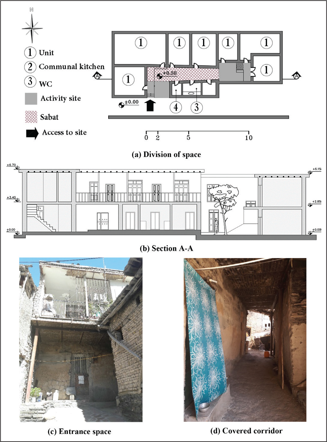
In this pattern, there is a hierarchy of shared space and shared facilities. The common space of the neighbourhood unit to the corridor and central open space has been divided between some units. Also, shared facilities such as cooking space, laundry and restroom are supported in the covered corridor, while social activities such as eating meals, meeting and talking to neighbours are done in the central open space at the end of the corridor. This pattern is different from the first pattern in the hierarchy of areas, degree of confidentiality, visual sight and the degree of invitingness of the shared space between the units. These differences have influenced the degree of interactions among the residents. Based on the observations of the first sample, the residents spend more time outside their units. In the second sample, the open space between the units is mostly used by the units which are arranged around the central yard and the residents whose houses are arranged in a row around the covered corridor are less inclined towards spending time outside their houses.
The Third Pattern (Neighbourhood-Kinship Units)
The hierarchy of access plays a significant role in the formation of this type of house and the areas have been accurately defined. The semi-public space of the valley is separated from the central yard between the units (Figure 5 & 6). This separation is done by a corridor called Sabat. Sabat is covered by one of the houses overlooking the yard and it creates a smooth transition as a buffer zone between the semi-private area of the central yard and the semi-public area of the valley. This mediating space is not merely a place for transition. Other activities have been defined in this space through designing the sitting and access of units in addition to the central courtyard which have increased the legibility and security of this space, which gives more identity to the space between the units and the valley. It should be noted that the ceiling, floor and walls of the Sabat are private and in fact, the units have defined this as buffer zone. This area is hence completely linked to the categorised houses around the central yard.
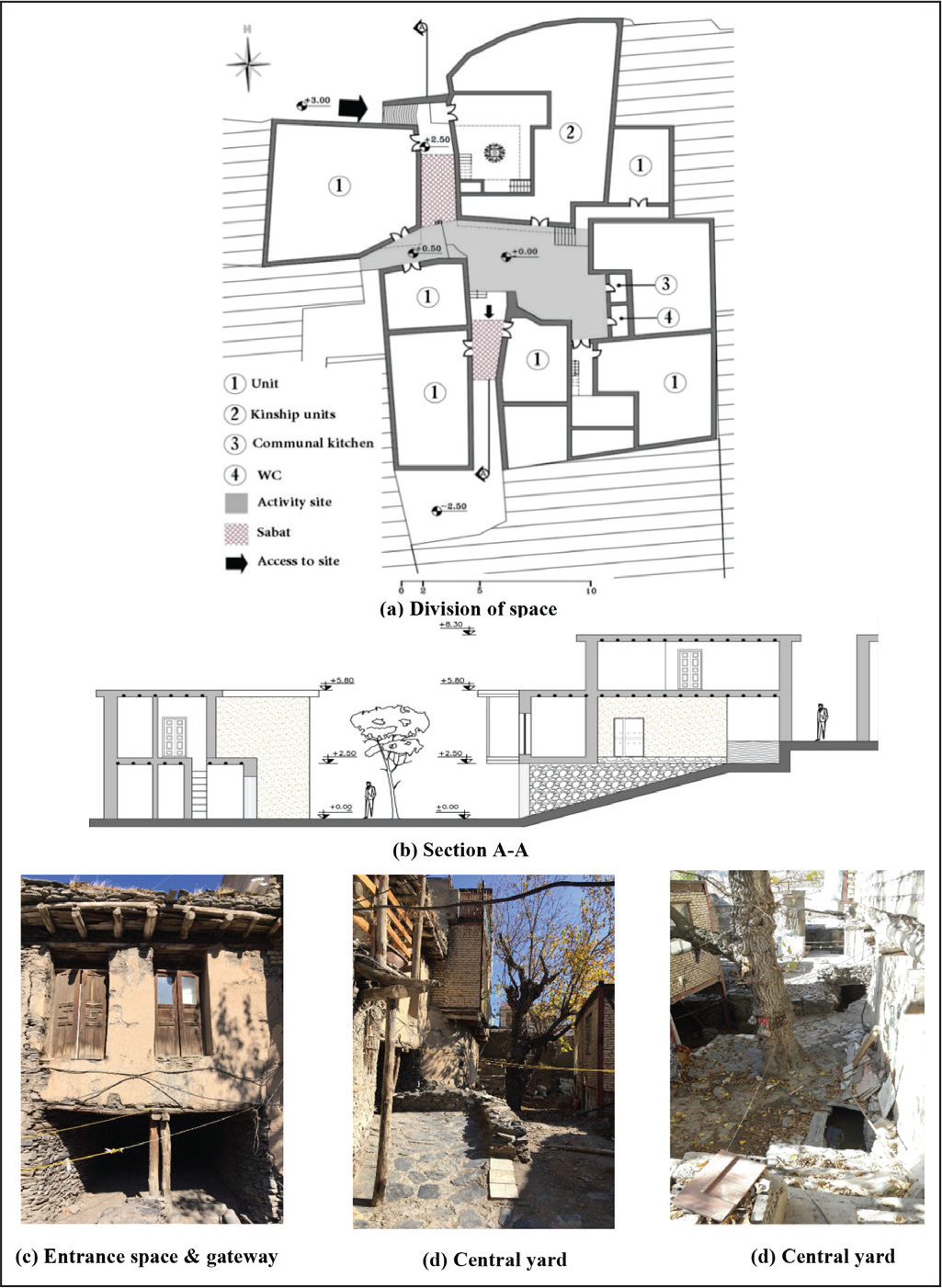
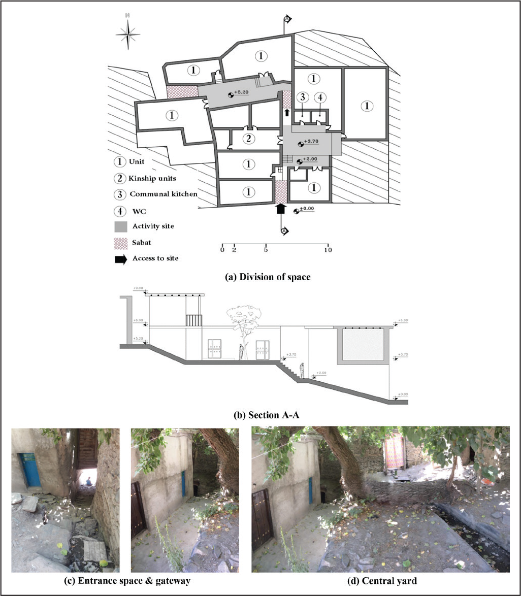
In this type of neighbourhood, kinship units have been separated from the central open space between the neighbourhood units by a door or wooden gateway. Residents in the kinship units have close relationships with other units and most of the time, the door or gateway of kinship units is open. Other units around the central open space have been arranged in smaller groups (2 or 3 units) and the shared spaces in front of the entrance doors have been defined based on their difference of altitudinal level from the central yard or have been separated by Sabat from the common space. Therefore, in this pattern, the hierarchy of access to the units is seen more often and units are grouped with distinct boundaries. It can be said neighbourhood-kinship pattern is a combination of the first and second patterns.
In this pattern, there are shared spaces such as kitchen, the space for washing clothes, joint restroom, the space for taking care of children and play, warehouse in the shared open space between the neighbourhood units. The central courtyard is where all the activities of the residents are organised and that is why it is considered as a life-giving space. The porch, courtyard and kitchen are often used by women for doing the household tasks and taking care of children. Men are rarely seen in the space of neighbourhood units on regular days of the week. They spend their rest time at the private space and usually spend time in valleys, public passages and gathering spaces at the centre of the neighbourhood. The shared spaces of neighbourhood units have been formed in order to fulfil the primary needs of the villagers, especially women, and provide a space for conducting shared activities such as eating with the neighbours, cooking food and taking care of children. Therefore, these neighbourhood units have been built to promote cooperation among the residents, give value to housework and make house activities enjoyable for women.
Features of this pattern, houses have been built in one or two-floor around the central open space. They have different appearances but all of them are in harmony with the neighbouring unit as a whole. Most two floor units have access to the first floor through inner stairs which are beside the warehouse and bedroom space. The spaces in front of the entrance doors of the unit which have been separated from the central open space by one or two stairs, act as the transition areas near the units in which the residents spend much time, either resting or talking to others. This space is also used for informal meetings. The kitchen is located at the centre of the open space of neighbourhood units. The size and form of the central open space and the fact that residents live on the first floor have resulted in good visual look-out from the units to the shared open space, which in turn encourages the residents to have more interaction with each other.
Comparison of the Residential Context of Azghad and Cohousing Practices
As mentioned earlier, one of the main goals of cohousing is to fulfil the tendency of residents to live in a socially supportive context (Marcus 2000, pp. 146–63). In cohousing communities, the physical environment which has been designed for the sustainability of social relations and the social environment, together with the physical system, can foster more social interactions among the residents. Therefore, in order to compare the residential pattern of Azghad with the cohousing model and investigate the shared interactions and activities of the villagers which are similar to cohousing, both social and physical systems have been discussed in the following sections.
Social System
Social factors and links which are themselves the product of collective goals and demands have resulted in the creation of collaborative residential patterns in the village. In line with the definition of cohousing, a model of society in which the ideal lifestyle of the residents has strong ties with the form of the built environment as well as high collaboration rate of the residents, have resulted in an autonomous society and a sustainable physical environment in social relations (Torres-Antonini 2001, pp. 1–33).
According to the population characteristics of the village, the residents are at the same level regarding social, religious, cultural and economic aspects, and there are not any ethnic or religious conflicts in the village (Khan-Mohammadi 2005, pp. 51–8). It could be said that the collaborative lifestyle of the villagers is positively influenced by their social similarities which is a precondition of compatibility in social relations (Abu-Gazzeh 1999, p. 43). Therefore, social homogeneity has been a crucial factor in the desire of residents to participate in interactive activities and it has created a form of residential space which is mainly focused on collective spaces. Similarly, in cohousing, the Cohousers have a lot in common in terms of affluence, social class, race, level of education and attitudes. According to many scholars, including Abu-Gazzeh (1999, p. 43) and Williams (2006, pp. 202–25), homogeneity within a social group reinforces social relationships.
In order to investigate the overlap between this type of housing and the cohousing model, one has to consider the family system of the villagers and the status of women as one of the aspects of the social system (Vestbro 1997, pp. 335–42). It has to be mentioned that the common residential type of Azghad emerged as an attempt to protect the privacy of the family, especially at times when men are outside the house, working in the gardens, houses have been formed in specific groupings and similar to the cohousing pattern with closed borders from the outside space. Therefore, this type of house classification has been formed with the aim of creating maximum security for women and children and in response to the interactive activities of the residents. During the day, the residents spend much time outside the house and share activities such as doing housework, while houses are mostly used for resting and sleeping. For this reason, the villagers use the Persian term ‘khanekhab’ which is translated as ‘the place for sleeping’, instead of using the word ‘house’.
Apart from social homogeneity, the solidarity of residents which have been the main factors in the formation of these type of houses, the high density of people and houses, especially in the old and central context of the village, may be considered as another factor which has played a role in the emergence of such type of houses. As Williams (2006, p. 198) mentioned, at extremely high densities, residents experience less control over their social environment and show tendency to separate themselves from the community, which they feel is invasive and uncontrollable. Therefore, the arrangement of buildings in small to broad groupings around the central open space or the semi-open covered corridor, protects the residents from being excessively exposed to the society, which may in turn lead them to have higher social interactions.
Also, in order to prevent the creation of ethnic or racial territories which may lead to contentions among the residents, the grouped houses have been considered as a subset of the larger community and residents communicate with other grouped houses in the centre of neighbourhoods and different spatial areas in order to perform large-scale social activities in the neighbourhood scale. Local place is to some extent a physical collection in which human interactions take place. It refers to a physical collection, but one which has been defined socially (Thrift 1983, pp. 1–30). Hence, the centres of neighbourhoods are highly important in forming the rural community, because of their functions such as unifying the society, providing the consumption and service needs of the neighbourhood and hosting daily social interactions especially for men.
Physical System
By following up the influence of social factors on the spatial and physical organisation of the village, the formation of collective spaces at different levels and in various scopes could be observed. As previously mentioned, Azghad has been divided into four neighbourhoods and the three older neighbourhoods have gathering centres. Each neighbourhood consists of numerous neighbourhoods, kinship and neighbourhood-kinship units, which are the subset of the neighbourhood as a whole. Houses have been clustered in three general patterns in specific social and physical systems, and each cluster having its hierarchy. It could be said that neighbourhoods have been formed according to the hierarchal system of the residents’ fields of activities.
Paying considerable attention to the pattern of passage networks is significant in cohousing design since they are indicative of the different zonings of the residents’ activities and the relationship between the fields of activity and social interactions. The pattern of the network of passages in Azghad has been influenced by environmental factors, especially uneven land and the social preferences of the rural community. Consideration of pedestrian circulation, human scale, human sight and visual variation is seen in the access networks of the village. Also, one can observe the hierarchy of the residents’ fields of activity in the passages and the passage’s width changes in harmony with the hierarchy of spaces.
There is a hierarchy of restrictedness and privacy in all the spaces proportionate with their function. Paying more attention to the privacy of collective spaces and the security of the children’s playing ground which are supported in the shared open space between the units, increases the interactions among the residents. In addition, the visual sight from the units to the inviting and accessible collective spaces attract people to come to the public environment and promote the security and privacy of the open space between the units. The only way to enter the semi-private zone of the units is through Sabats. In addition, kinship units have complete restrictedness from the surrounding context and are separated from the valley by a door or gateway. However, since the residents have closer relationships with each other, the inner space of the units is friendlier and there are semi-open spaces in the form of a terrace, porch and access stairs to the first floor.
Based on the arguments elaborated by Vestbro (2010, pp. 5–9), cohousing is here defined as housing with common spaces and shared facilities. Inner and outer social facilities exist in the micro and macro levels of the village’s design. At the neighbourhood scale, the neighbourhood centres can be mentioned as the social centres of the village. At the scale of neighbourhood and kinship units, service spaces are supported outside of the private units by providing collective and shared facilities such as kitchen, restroom, bathroom and children’s playing space. Therefore, the shared activities and housework such as cooking are done in the joint spaces between the units and this makes work enjoyable for female members of the family. Moreover, common routes to activity sites have also increased the potential for social interaction.
Transition areas between the private and public spaces of the village have been carefully articulated in order to distinguish between the two. Several studies have demonstrated that the gentleness and smoothness of transition between the private and public areas in designing the open space of the cohousing has an important role in enhancing the interactions between the residents. In order to determine where the public space ends and the private and semi-private transition area start, many measures are taken, including a change in the altitudinal code, using a stone bench, using covered corridors with a gentle slope, smooth transition from the semi-private space of the valley upwards or downwards, using wooden doors, gateways and awnings. In addition, the transition spaces between the residential units and their common space have been defined very well. The bordering between private, semi-private and semi-public spaces has been created through providing semi-private and semi-open spaces in the form of terrace, porch, stone bench and access stairs to the private units in the open space of neighbourhood units.
Conclusion
Comparison of the Case Study Communities’ Personal and Social Factors.
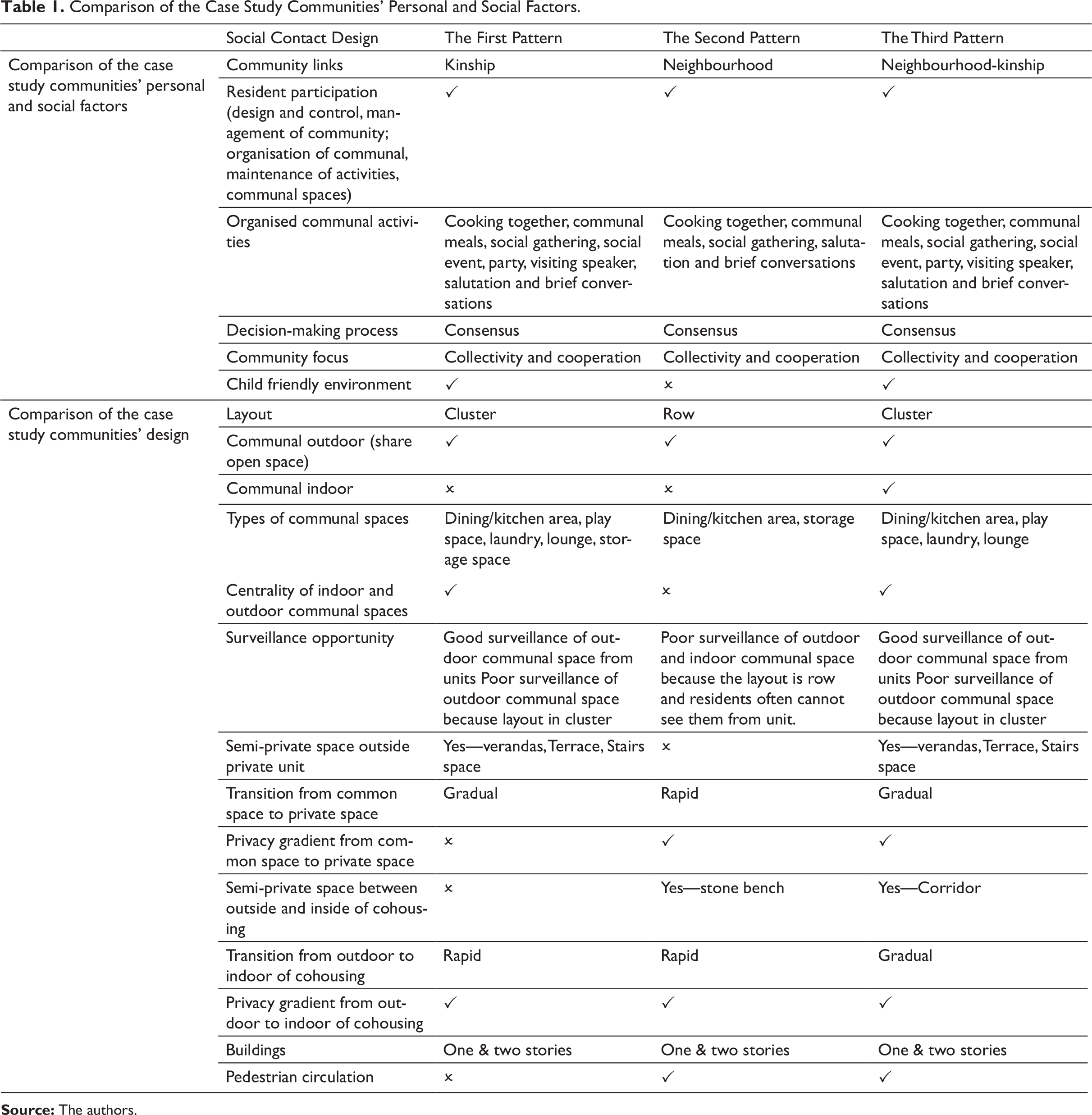
The spatial organisation of a village is important in the collective concept of the village and its physical system is formed based on the social background of the residents. In other words, the spatial patterns of the housing styles of the village are manifestations of the social patterns and shared values of the people living in that society. Based on the investigations and comparison of the social and physical system of the residential context of Azghad and cohousing neighbourhoods, the residential type of the village seems to be a historical instance of the collective housing style which has emerged through time based on the shared values of the residents and the activities which they wanted to perform collectively.
Footnotes
Declaration of Conflicting Interests
The authors declared no potential conflicts of interest with respect to the research, authorship and/or publication of this article.
Funding
The authors received no financial support for the research, authorship and/or publication of this article.
