




Abstract
Water scarcity in Narok county, Kenya may be attributed to demographic pressures, land-use changes, environmental degradation and the effects of climate change. This article combines methodologies from history and political science to investigate how local communities cope with water scarcity. In so doing, we consider how institutions, both indigenous and modern, mitigate conflict over access to and control of water sources. Cases are presented from sites of irrigation and development projects or plans. We find that climate change has little to do with water conflicts in Narok, but that more important factors are privatisation and commoditisation of formerly common-pool resources, and challenges and failures in modern water governance in mediating between Maasai (pastoralist) and non-Maasai (agriculturalist) groups. Indigenous governance institutions still have a place in conflict resolution and environmental protection.
Introduction
A recent media article provided a graphic description of water scarcity in arid and semi-arid lands (ASALs). Women from a village in Maasai Mara, Narok county recalled often walking for 13 kilometres in search of water, travelling in groups for protection against wild animals until they reached a seasonal river. At dry times, they would dig wells in the river bed and wait in the night for them to fill, again guarding them against thirsty wild animals. In 2013, various stakeholders in partnership with the Narok County Government constructed a pipeline from a natural spring to the village. Residents now pay a monthly access fee of Ksh 100 (US$ 0.92), which is reinvested in the maintenance of the infrastructure at the water points, although not all can consistently pay (Mbugua, 2020). Such water developments can make huge differences in ASALs, but are not without their own challenges as this article explores.
ASALs constitute 43% of Africa (De Jode, 2009) and 89% of Kenya’s land surface (Republic of Kenya, 1980). In Kenya, most of these lands have a high population of livestock-keeping nomadic pastoralists, able to subsist in a challenging environment through adaptations such as mobility over the vast rangelands. ASAL ecosystems can provide essential goods and services, both tangible and intangible which are crucial for satisfying human needs. Furthermore, systems and institutions have developed over time to govern the sustainable use of water and conservation of catchment areas. These have often extended into the management of land and other natural resources (Gaur & Squires, 2018). They are not always effective and cycles of pastoralist resource-based conflict are common.
However, in recent decades, we see ASALs facing even more challenges as a result of climatic pressures, environmental degradation and ambitious development agendas and projects frequently sited within them (Bedelian & Ogutu, 2017). In terms of climate, modelling suggests that the East Africa region could potentially experience a rise of 2–5 degrees Celsius by the end of the 21st century, and probably higher rainfall (Niang, 2014; Potsdam Institute for Climate Impact Research and Climate Analytics, 2013). In Kenya’s ASALs specifically, Ogutu et al. (2016) found evidence of temperature rises in the ASALs of Kenya from 1960 to 2013 by perhaps as much as 2 degrees Celsius (rainfall trends are rather inconclusive). Moreover, the UN Environmental Program’s Global Environmental Outlook GEO-6 Regional Assessment for Africa (UNEP, 2016) mentions many pressing environmental challenges for Africa other than climate change including pollution, land-use changes and loss of biodiversity from a range of factors including population increase, urbanisation, industrialisation and deforestation. Likewise, Kenya’s Vision 2030 development agenda, which aims to transform the country into a newly industrialised middle-income country by the year 2030 (2030 Water Resources Group, 2015), brings new contenders for available water resources through varied and dynamic economic activities such as agriculture, wildlife tourism, infrastructure, construction, industry and energy production. Large-scale water developments to support urbanisation (such as dams and reservoirs) threaten downstream users in ASALs. Showers (2002) notes that urban-rural water cycle linkages in Africa need to be recognised and ecosystems protected, while Adams and Smiley (2018) argue with regard to Malawi that despite improvements in water supply,inequalities between rural and urban access persist.
Given the current focus upon climate change around the world, pastoralist conflicts in northern Kenya have been attributed to these dynamics and labelled ‘the world’s first climate change conflicts’ by some observers and development agencies (Christian Aid, 2006). However, pastoralist conflicts have a long history and climate change is likely, if anything, to be only part of the story. As suggested above, environmental degradation and increasing competition for water and land as a result of development and immigration are also likely to play a role. In the context of these new pressures, it is important to understand the role of resource governance, both modern and indigenous, through which resource conflicts may potentially be stoked or mitigated. This article uses a historical and political science perspective to examine the relationship between water scarcity and violent conflict, and the role of institutions, particularly grassroots institutions in managing conflict. We focus on a semi-arid pastoralist area in Narok county, Kenya, where land and water have been common-pool resources governed by practices which are likely to be under increasing strain from development projects. We aim to better understand the socio-ecological aspects of inter-communal resource-based conflict, and the success or otherwise of the various approaches to water stewardship in a water-scarce context.
Environmental Scarcity, Conflict and Institutions
Narratives of conflict in pastoral East Africa frequently emphasise the problem of aridity as an important driver of conflict. The well-known environmental scarcity theory, refined over time, assumes environmental scarcity to be a major causal factor (independent variable) in conflict in many developing countries. Such scarcity is seen as a product of the decrease in quality and quantity of environmental resources (a reduction in the size of the pie), an increasing population (the need to divide the pie into smaller pieces) and an uneven distribution of resources (uneven slices of the pie) (Homer-Dixon, 1994). Through a variety of direct and indirect effects on regional agricultural production and the economy, climate change and environmental degradation increase the risk of intra-state conflict (Homer-Dixon, 2021).
However, political ecology theorists argue that power, access, control and struggle are at the heart of so-called resource conflicts while environmental scarcity is seen as a contextual issue, a result of the political context, and a ‘threat multiplier’ rather than a threat in itself (Floyd, 2008; Le Billon & Duffy, 2018). The environmental scarcity model, they argue, is overly vague, simplistic and deterministic, among other problems (Hartmann, 1998; Peluso & Watts, 2001). Some authors also point out that tensions and contestations can actually lead to new ideas and adaptations ultimately mitigate resource scarcity and lead to increased resilience (Simon, 1994; Lomberg, 2001 both quoted in Floyd, 2008). Again, challenging the notion of a predictable relationship between resource scarcity and conflict, Raleigh and Kniveton (2012) in their quantitative study of East Africa provide a variety of potential scenarios: Firstly, competition for scarce resources may lead to conflict, but secondly, resource scarcity may mean that there is nothing worth fighting over, thus peace prevails. Thirdly, resource abundance may lead to greed-motivated conflicts, but fourthly, it may also lead to self-sufficiency and again, peace. Both extremely high and extremely low rainfall led to increased conflict, lending credence to these assertions. Furthermore, some authors bring out the role of institutions in resource conflict. Linke et al., (2015) in examining climate, resource scarcity and conflict note that various factors vary the effect that climate and environment have on conflict, including institutions. Buhaug et al. (2008) argue that the absence of good institutions may be an important trigger in resource-based conflict.
Chhotray and Woodhouse (2005:3) discussing India and South Africa note that water rights tend to be ‘mediated by a complex interplay between the formal legal structure and local governance arrangements that may or may not be the consequence of customary rights’. In this article, we focus upon institutions both traditional to modern, and their role and effectiveness in managing water resources and mitigating conflict where finite, often scarce ecological resources are often shared between large numbers of users. Vatn (2008) in his book chapter on sustainability and institutional change tells us that institutions are the conventions, norms and rules for society, and a kind of context for various rationalities such as ‘I’ (individualism), ‘we’ (pluralistic) and ‘they’ (altruistic) arguing that there is much evidence for the prior dominance of the ‘we’ rationality seen in the principles of reciprocity and redistribution in many societies; this we expand upon in the pastoralist ASAL context. We also look to Ostrom (1990), who in her landmark book on governing the commons provides some practical principles for success, such as boundaries and contextually relevant rules, monitoring and reasonable sanctions to enforce rules, conflict resolution mechanisms, participation, recognition by higher authorities and links to wider networks of cooperation. Thus, we see not only the centrality of institutions in common-pool resource governance, but also their interaction with external agencies; in the case of our work, this would include the modern institutions for water governance.
But how do these institutions fare in the changing context? And how effective are the newer formal institutions? Linke et al., (2015) quantitatively investigate the question of the effectiveness of local traditional institutions for mitigating inter-ethnic conflict in situations of increasing water scarcity in Kenya. They find that local informal dialogue works as an important institution to mitigate violent conflict risk, while government/formal institutions do not. They speculate that the latter may be less responsive to local needs, may exclude certain groups or that there is a lack of effectiveness due to the recent state of flux brought by a change in the country in 2013 to a devolved system of government. We come at a similar question from a qualitative angle to gain a more detailed understanding of the strengths and weaknesses of various institutions involved in the shared use of scarce water resources.
Findings in Narok county
Study area
Narok county which lies around 50 km from Nairobi is around two-thirds semi-arid rangeland (Narok County Government, 2018). It has a population of just over one million (Kenya National Bureau of Statistics, 2019) with an annual population growth rate of 4.7% contributed partly by high immigration. Historically, the Maasai are the natives of Narok; however, the areas currently inhabited by the Maasai were forcibly allocated under the agreements with the British in 1904 and 1911, in which Maasai lost their rangelands in Rift Valley and Laikipia, and were forced into the Southern Reserve (parts of what is now Narok and Kajiado counties). Hughes (2005, p.208) writes, ‘A combination of factors - driven by the moves and by colonial intervention as a whole - have since led to acute population pressure, land degradation, erosion of subsistence livelihoods and increased vulnerability to drought’. These dynamics have resulted in ethnopolitical tensions.
Water development in the county has been minimal, despite being fairly close to the capital and only Narok town and Ololulunga town (which lies near a water tower) have a reliable supply of water. Smaller towns may rely on bowsers while most rural people rely on natural sources, water pans (shallow hand-dug ponds), dams, wells and rainwater harvesting, and are therefore largely unaffected by urban water use and supply. Pipelines, canals and boreholes were constructed from the colonial era onwards but have often been unsuitable or poorly maintained. Drought is not a new phenomenon in the county: severe droughts have been recorded from 1926–1929, 1934 and 1942 (Kenya National Archives, 1930, 1934 and 1942), as well as some severe floods as a result of flows from nearby escarpments and highlands. Temperatures in the county have risen between 1960 and 2014 (Ogutu et al., 2016) and the area has suffered environmental degradation particularly of the water towers of Maasai Mau forest complex, Loita hills and Enosupukia. This is characterised by unregulated settlement, land-use change to irrigation agriculture, deforestation (Figure 1 ) and sand harvesting, leading to soil erosion, landslides and a decline in water flow in East Mau (Kenya Water Towers Agency, 2018; Mutugi & Kiiru, 2015). There are now eight irrigation schemes in Narok county (of which the two largest schemes are Narosoora and Mosiro which were visited for this study). Maps showing changes in land cover from 1990 to 2020 in the study area. (Source: Kenya Water Towers Agency (KWTA)).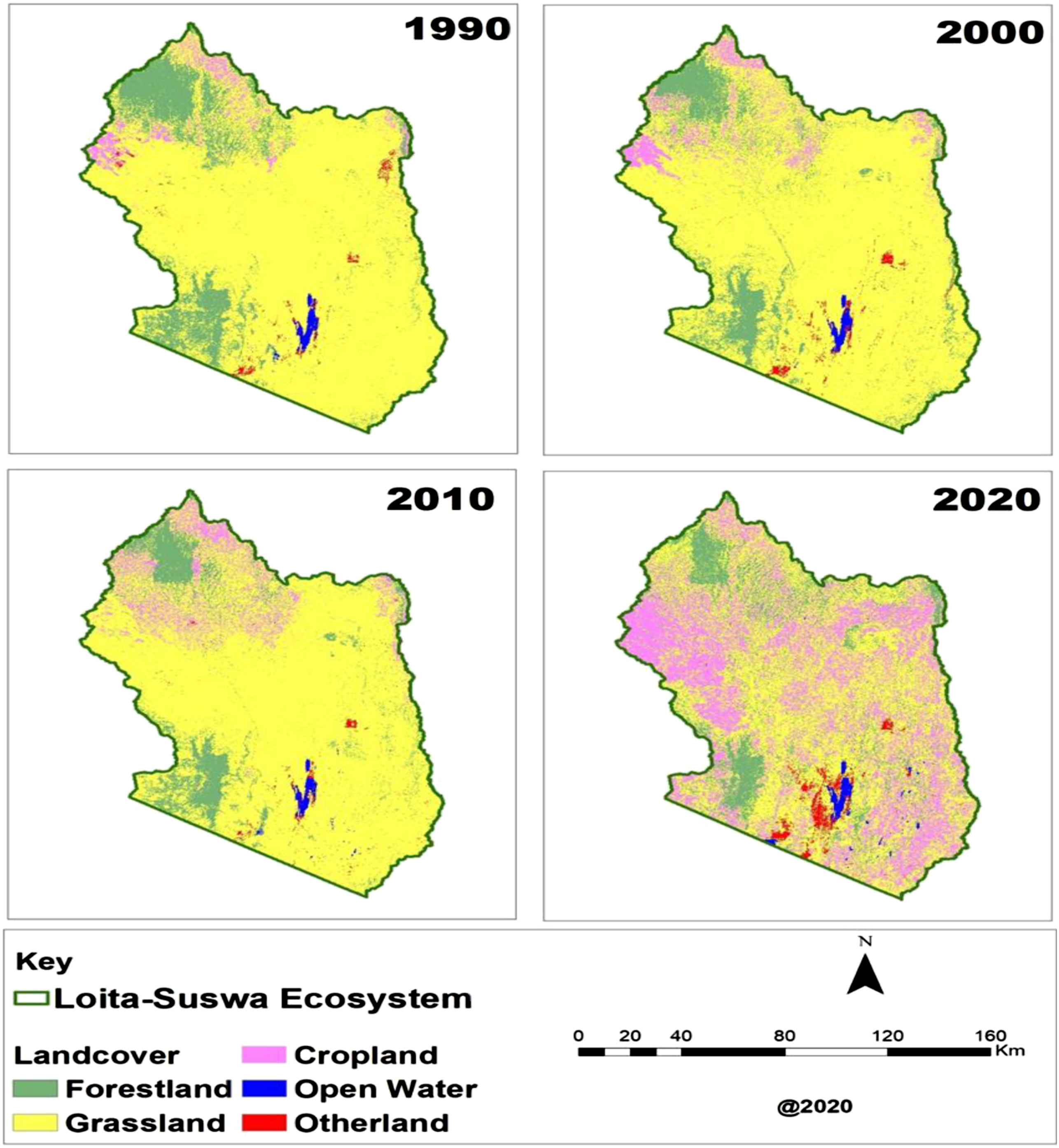
Historically, land tenure has been communal, with the exception of some large chunks of land given to colonial settler farmers and also the original removal of Mau forest complex from the Maasai to Kenya Forestry Service for conservation (and plantation) in the 1950s. The colonial government having relocated the Maasai did subsequently endeavour to prevent non-Maasai from settling or cultivating in the district (Hughes, 2005; Narok District Annual Report, 1923, p.3–4). However, immediately after Kenya gained independence in 1963, the numbers of immigrant cultivators in the county increased with an influx of Kikuyu, Kipsigis and Kisii amongst others. Areas previously designated as dry season grazing reserves such as the Loita hills, Soit Ololol and Nguruman escarpments were also brought under cultivation (Republic of Kenya, 1980; Sindiga, 1984). From the 1960s, group ranches were introduced in Kajiado and Narok for Maasai communities to provide the security of a group title and possibilities for loans and commercial production. However, these were impractical and failed to benefit most members ; (Galaty, 1992; Ng’ethe, 1993; Ole Pasha, 1985). Most group ranches are now subdividing or have subdivided, which has led to individualised models of land-use, threats to common-pool resource access and land-based conflicts (Mukeka, Ogutu, Kanga & Røskaft, 2019; Gartner, 2015).
We examine two semi-arid sub-counties in Narok county with study sites in Naroosura-Loita, Mosiro and Suswa areas (figure 2). Archives since 1897, other historical sources, and government and civil society reports were important documentary sources for the work, as was the Armed Conflict Location and Event Data Project (ACLED) database (Raleigh et al., 2010). This was complemented by stakeholder interviews (80) carried out with administrators, officers of parastatals and other water governance institutions, civil society officers, police, pastoralists and farmers, and other community members of various ages. Sites of conflict to be visited within the county were identified through interviews with key informants. Map showing the study area including the selected sites.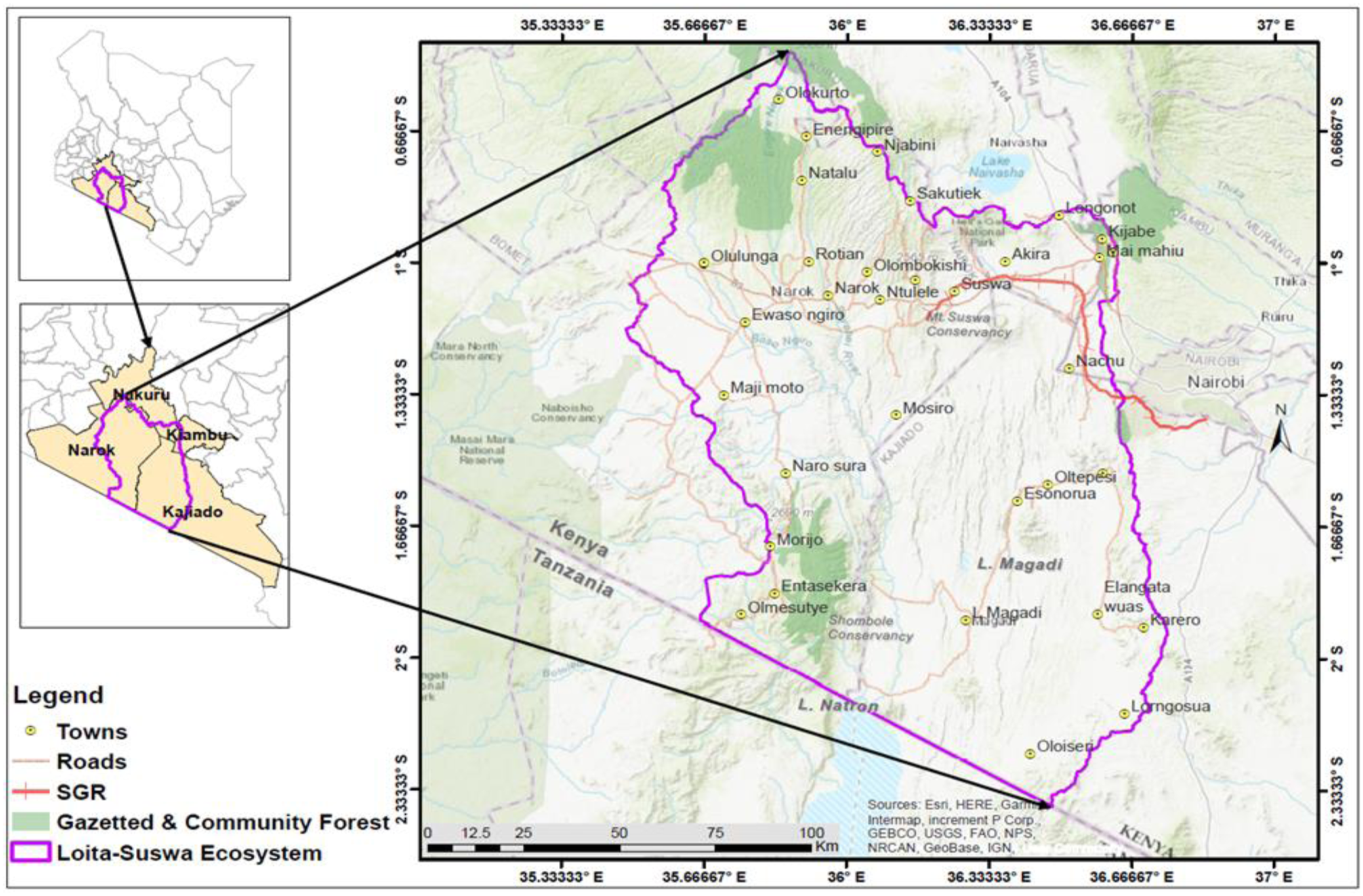
Institutions for Water Governance
The Olosho is a territorial section of Maasai lands, governed by a council of elders, of which there are 12 in total (four within Narok). The Olosho is responsible for the regulation of grazing patterns and management of other natural resources like water points within their jurisdiction. They carry out dispute settlement and give punishments, usually in the form of fines. Moran (youths of a certain age whose role is herding and community protection) seek and protect community water sources. Under the leadership of the Olosho, specific water points are identified and set aside for livestock watering and others for domestic water harvesting. Traditionally, cows have not been kept close to rivers, to avoid overgrazing and malaria. The responsibility of ensuring livestock have water traditionally belongs to men while women have domestic duties and are permitted to collect domestic water from anywhere. Women have also traditionally played an important role in monitoring water levels and quality for domestic consumption. An elder explained the ethos of common ownership reflected in past practices, Water sources could not be owned, they were sacred places under the custody of the elders who regulated access …You could be cursed if you did not act in the interests of the community and future generations.
1
An exception to the rule of common ownership and access is that water pans, dams and wells have always been subject to private arrangements with those individuals or groups who developed them.
Most respondents believed that since Maasai are used to water scarcity, internal conflicts over water have not been common or severe, as noted by one, There were no conflicts a long time ago. If you dug your dam, we would borrow water for cows or domestic use. People loved each other. If you had water, mothers and children would access it freely to use the water. [For] cows you had to request permission for [them] to drink the water.
2
While perhaps somewhat rose-tinted, the account suggests that institutions functioned well, notwithstanding that the system was less strained than at present.
The Laibon/Nkidongi (the guard, office of the prophet) are also relevant to water governance; they are members of a sub-clan believed to have divine powers which are passed down from father to son. The chief Laibon who currently resides in Loita forest and is seen as a guardian of the Loita Forest can curse or ostracice an individual from the community for abuse of the forest and its resources and can also intercede for rain (Ole Riamit, 2010). His role in water governance is further illustrated in the Loita case to be described.
Indigenous institutions for governance and conflict resolution are still used and are often preferred due to their relevance and responsiveness, 3 as the Naroosura case illustrates. However, according to Zaal and Ole Siloma (2006), over time, they have been weakened by the emergence of complex formal institutions and political structures. Sometimes, traditional institutional actors have been open to new ideas and engagement with formal government institutions and the private sector. Chiefs are also used as neutral arbiters and their decision is respected and the consensus reached is owned by the community. 4
Key events in water development from the colonial era to present.
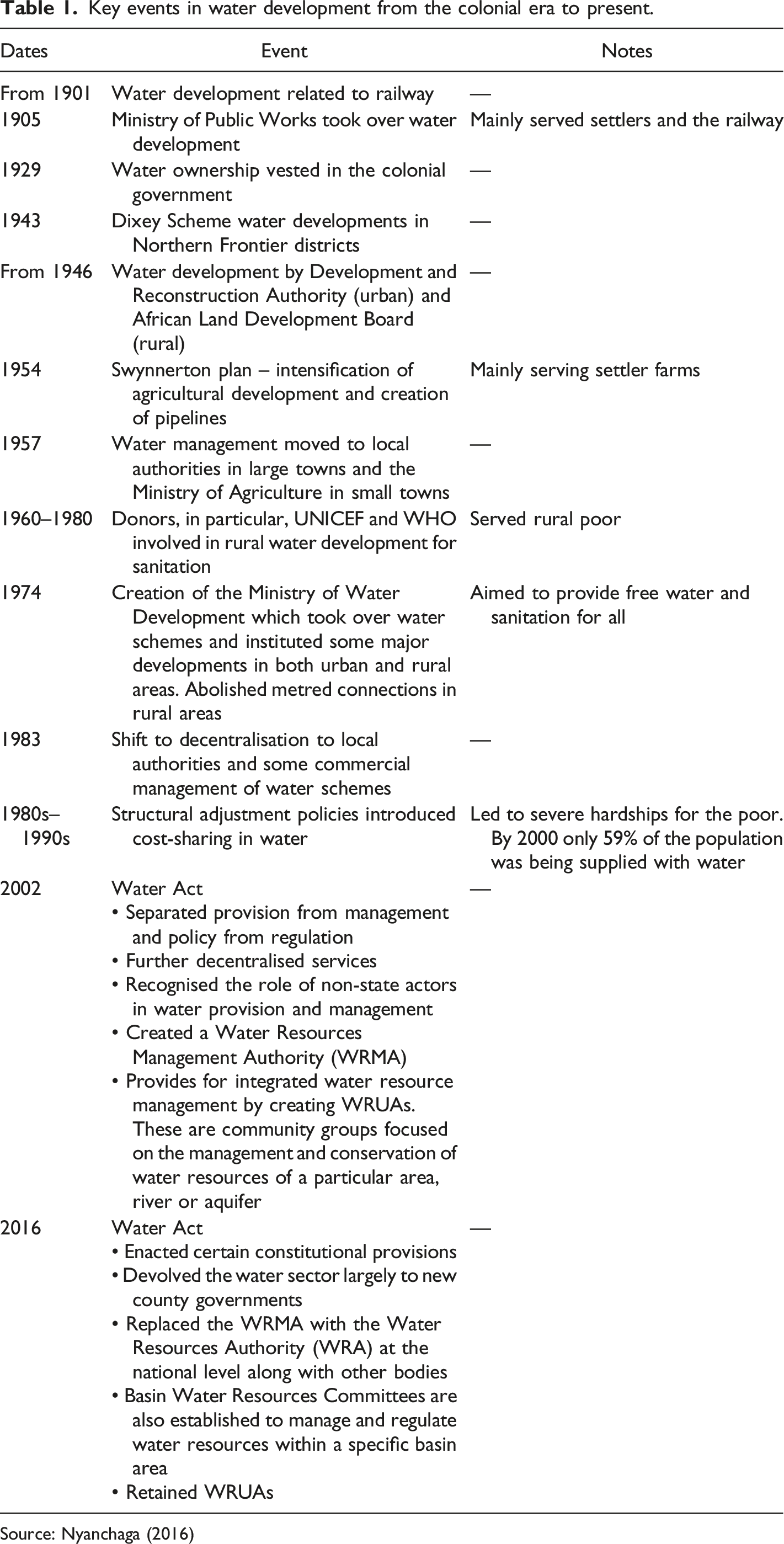
Source: Nyanchaga (2016)
Water Resource Users Associations (WRUAs) are the lowest organisational level of water management in the Kenya framework. Their roles include involvement in the decision-making process to identify and register water users, collaboration in water allocation and catchment management, assisting in water monitoring and information-gathering, and conflict resolution and cooperative management of water resources. They create sub-catchment management plans which include duties such as controlling abstractions, pollution control, protecting springs and riparian zones and improving farming and land-management practices (Richards & Syallow, 2018).
Naroosura: ‘Cultivating immigration and harvesting conflict’?
Naroosura is a remote location in southern Narok about 60 km along an unpaved road after turning off near Narok town. The town and surrounding area rely upon the various rivers and springs from the nearby Loita hills for water, 5 while in the drier plains and lowland areas, dams, boreholes and water pans are used, and a 44 km pipeline comes from the river. Several agencies have tried to remedy the water scarcity in the area; Action Aid constructed the pipeline, the World Bank Group (WBG) has invested in boreholes and dams, 6 and parastatals such as the Ewaso Nyiro South Development Authority (ENSDA) and National Drought Management Authority (NDMA) have invested in water projects in the water-scarce lowlands with mixed outcomes. 7
The area is home to the 64,000-ha Naroosura Group Ranch which is in the process of subdivision (explained previously). This subdivision has opened the way for irregular land allocations and various conflicts over land and water given the high potential of the area for irrigated farming. There are legal disputes relating to allegations that officials have allocated themselves large portions of land up to 50 acres near the river at the expense of others. 8 Some of those involved are political elites; one local politician’s father managed to acquire a title for 3500 acres, while his wife who is also a politician has been trying to acquire 700 acres. 9 This is not an unusual report in accounts of group-ranch subdivisions.
Irrigated crop production in Naroosura has been going on since 1944, when Maasai evangelist, Jacob Nakola, of the African Inland Church (AIC), with the permission of the locals, settled and dug a canal two kilometres long from the Naroosura River. His farming techniques intrigued and motivated the residents. He lived here, and nobody could interfere with him … He was the first to plant oranges here and we grew up eating oranges from his farm. On Sundays after his sermons, he would give us sugarcane [and] oranges to motivate us to come to church… that is how irrigated farming began in Naroosura.
10
The area under cultivation expanded over the years to nearly 1500 acres (Narok County Government, 2018). Over time, NGOs and faith-based organisations such as World Vision came to Naroosura, provided seeds and pesticides, and introduced dairy farming. 11 In the 1990s, in other areas such as Loita-Entesekera, subsistence farming was introduced through the Ilkerin Project by the Dutch government through the Catholic Diocese of Ngong. Most of the canals were developed by the community themselves with no outside assistance and are as yet uncemented. 12
About 85% of the farmers in Naroosura are immigrants from various parts of Kenya and even other eastern African counties, leasing land from Maasai landowners, who sometimes use their profits to build up their herds. Land is leased for a growing season for between Kenya Shillings (KShs) 3,000-10,000 (US$25–84) with highest rates near the river. In recent years, some wealthy immigrant farmers have been able to develop large modern farms, such as one Kikuyu farmer with 100 acres under irrigated farming. 13 In another story, an immigrant farmer began as a casual labourer and was able to eventually invest in buying a water pump and 86 watering pipes. His former boss now uses the equipment in a profit-sharing arrangement. 14
The Naroosura WRUA covers Naroosura and three other locations, constituting 75% pastoral rangeland and 25% irrigated farmland. Ten dams, seven boreholes and 25 canals are overseen by this WRUA which addresses flood management, soil erosion, degradation and water pollution by developing sub-catchment management plans with guidance from by-laws. The board of the Naroosura WRUA is composed of chairpersons and secretaries of more localised irrigation canal management committees in the area which schedule irrigation. 15 The WRUA has carried out some helpful initiatives including fencing off the catchment area, that is, the two springs that are a source of the Naroosura River, and construction of a watering trough for livestock and a water point for domestic use at the river source to help avoid conflict. Similarly, in Loita-Entesekera, the water management committee has fenced off the source of the spring. Challenges for the WRUAs include maintenance challenges, water quality which is compromised by chemicals and human activities, enforcement of by-laws regulating extraction quantities and non-payment of the annual membership fees. 16
Water conflicts documented in police occurrence book September 2019–September 2020
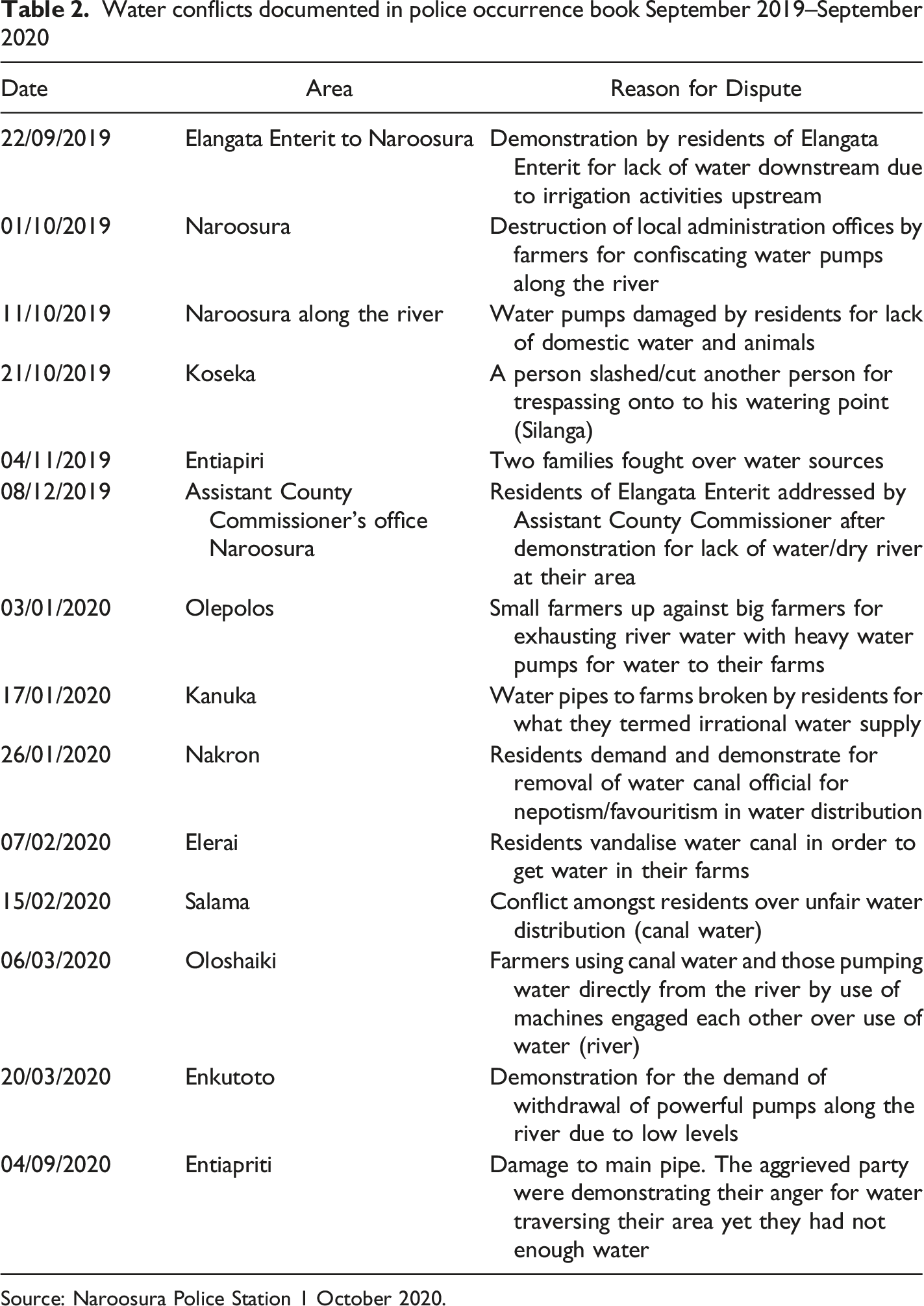
Source: Naroosura Police Station 1 October 2020.
Conflict is common between upstream (irrigation farming) and downstream (pastoralism) users a few kilometres away.
19
This is despite irrigation schedules which also allocate times for watering of livestock only. Conflicts often become violent, and police often get involved.
20
As a pastoralist narrated Farmers here use all the water and if one follows the Naroosura river, from Elangata Enterit it becomes seasonal unlike before when it would flow up to Lake Magadi …. When it reaches July, August, and September, we are always hustling for water because it is the dry season and that is when we come upstream to destroy dams here and burn generators …. we never have any problems with the people of Naroosura except during the drought period.
21
Pastoralists, especially wealthy livestock keepers, may also cause problems for farmers, as noted The locals here have many cattle and during the drought, they take them to the forest for grazing …. For example, we have a case today that the chiefs are handling. There is a man who has about 700 bulls without counting cows and calves…he is known as Mali Ngumu (hard wealth). He was ordered by the [government administration] to sell some so that others may have places to graze… he takes all the grazing area since it is communal land … when he takes his livestock to graze up the hill, all is usually okay. However, when bringing his livestock back to drink water, he traverses through the riparian land that is under cultivation … this creates problems at watering points or in the grazing field.
22
Resentment of immigrant farmers leads some pastoralist Morans to make trouble for farmers. One farmer had his phone taken.
23
Another noted, Farming has not been that stable because we have a group called Maasai morans... The outsiders are afraid of them … Hence, outsiders undertaking farming in our area are reducing … Harassment by the morans was the reason why they left. When the COVID-19 pandemic started, people were also affected. However, some are still farming, and you get morans invading farms and they forcefully snatch phones and cash from people, and that is a problem.
24
There does seem to be a mechanism for managing this conflict however, Nowadays, if morans attack people on farms and the incident is reported, so long as the culprit is known, those things must be returned to the owner, and maybe a fine might be imposed to compensate the affected persons...We have cultural leaders who can punish the morans for going against the customs of the community.
25
This suggests that even though WRUAs manage the distribution of water in the irrigation schemes, indigenous governance has not lost its relevance in managing conflict when things go wrong.
Loita: Threats to the forest and ‘towering’ leadership
The Loita Forest is a water tower and a vital resource. On the eastern side of the forest, water is in abundance and the residents practice subsistence farming, though commercialised farming is somewhat curtailed by a bad road connection to the towns. Subdivision of the Forest complex has not yet occurred here, but there are sentiments that if it were not for the strong leadership of the Laibon, the area would have gone the way of forest encroachment, land subdivision and deforestation, which would threaten water availability and Maasai livelihoods. 26 Other threats include development projects such as a road through the forest, proposed in 1997. While proponents welcomed a faster and shorter route through Magadi to connect them with Nairobi and Tanzania thereby facilitating quicker transportation of agricultural produce and livestock, among other benefits, opponents rightly fear that the road would be the thin edge of the wedge for immigration, land-use change and destruction of their ecosystem and culture. 27 They specifically cite the parallels between the threat to the Loita Forest and the deforestation of the Mau forest following its removal from Maasai management (Ole Riamit, 2010). The previous Laibon known as Sendeu had tasked his son and successor Mukombo not to allow the Loita forest to go the same way as the Mau. With assistance from international bodies, they successfully resisted the handover of the Loita forest to the Narok County Council in 1993.
The Water Towers Authority which was established in 2012 ‘to coordinate and oversee the protection, rehabilitation, conservation and sustainable management of all the critical water towers in Kenya’ is also responsible for Loita Hills and has opposed the proposal for a road. 28 The Loita-Naimina Enkiyio Conservation Trust, a hybrid arrangement between the council of elders and NGOs, has also played an important role in the legal protection of the forest. 29
Mosiro: Wealth ‘flows’ and resource ‘diversions’
Mosiro is a dry lowland area around 30 km from Naroosura, separated by a ridge. Here, historically, pastoralists have relied upon water pans and seasonal rivers during rainy seasons, 30 and the Narok Ewaso Nyiro River. 31 The main town is 7 km away from the Ewaso Nyiro which, ironically, is prone to flooding, exacerbated by deforestation of the surrounding highlands. The area is also a wildlife corridor, leading to human-wildlife competition at water sources, and the destruction of water pans when elephants enter them. 32 Various boreholes near the town, and in remote areas, have been drilled and upgraded by state and non-state organisations. These are functional and important water sources for the locals. Borehole use is charged, for instance, at 500 KShs (about US$4.20) per 20 cattle, per month by locally elected borehole committees which govern and maintain the boreholes. 33
To mitigate problems of food insecurity, a large irrigation project was started in 1989 with help of government and donors including World Vision, World Bank and African Development Bank. It comprises around 800 acres under cultivation (Narok County, 2018), irrigated by gravity from the Ewaso Nyiro River. 34 Like Naroosura, the area is a former group-ranch land, which has completed or is in the process of adjudication, and the land under the scheme belongs to many of the original members, who own around 1–2 acres within it. Some of the original group-ranch members are not involved in the scheme but have now seen the profitability of the project and this brings tension.
As in Narosoora, the scheme has attracted many immigrant workers and investors.
35
They lease the land from Maasai owners at around KShs 5000–6000 (US$46–55) per growing season, or invest and work with Maasai farmers. This is very little lease income for the landowner in comparison to the kind of profits that some farmers can get. Esther (name changed), a non-Maasai farmer, said, Per acre, I can use KShs 90,000 (US$756) then I get a profit of 300,000 (US$2520) depending on the market price, but at times if the price goes up, we can get even 500,000 (US$4600) when the season is good.
A wide range of crops including onions, tomatoes, butternuts, cabbages, bananas, bell peppers, chilli peppers, potatoes, watermelons, beans and maize are grown and can easily be sold in the nearby towns and outskirts of Nairobi. Tomatoes and onions, the most popular cash crops, are water intensive. 36
There are also concerns about environmental degradation through deforestation and the use of chemicals. Said one farmer, Of the KShs 90,000 (US$756) invested, nearly 50,000 (US$420) is used on chemicals, medicines for the cold, flowering medicine, pests and fruit medicine … you have the starter, for dudus (insects), cold, folio buster, fruit and flowering, calcium, harvest-spread cold medicine. All these chemicals must be bought.
37
A young man noted that Toyota Proboxes are used to collect tomatoes and take them to market. ‘I carried 15 times full in a Probox. I am a farmer and a broker. I assist to get the buyers. One bread crate [sells at] KShs 1560 (US$14.35)’.
38
Some see brokers as exploitative, taking advantage of farmers who are limited by the poor road infrastructure.
39
Although many non-Maasai are benefiting from the project, more Maasai are becoming interested in farming too, including the broker, who explained, Now it is more of locals because before [we] did not know how to do farming, because we are pastoralists and now [we] have learned … even when foreigners started doing watermelon here, and they see people eating, they would laugh and ask why people eat pumpkin … so once they discovered, they changed, and now they do farming … some have even built their houses through that.
40
Members pay KShs 500 (US$4.60) per month to committee members for maintenance of the scheme, though many do not manage to pay. Maintenance is a challenge and sometimes conflict is exacerbated by siltation which reduces water flow, leading to people bribing to get more water.
41
As in Naroosura, there are frequent conflicts between non-local farmers and Maasai pastoralists who resent the presence of the former. The absence of a police post in the remote area is an important enabling factor in conflict as noted, We have morans who come to destroy non-locals’ crops … The other day they came harassing people to give them money or a phone ‘if you have sold tomatoes’ … There is no security, so they take advantage…
42
Another staff member complained that despite their attempts to provide water troughs for cattle, young herding boys still cause trouble, We have a place set for them to drink water, but even now they come into the scheme…some even break pipes to get water for their animals… some don’t care about the project.
43
It is not clear why herders would break pipes rather than use the troughs, which may again be an issue of maintenance, or the difficulty for child herders to completely control cattle. In these situations, sometimes, the scheme members carry out a citizens’ arrest and contact the chief who enlists the help of village elders and appointed community police to talk to the perpetrators. 44 It was noted that the Moran respect elders and are more likely to attack when elders are away. 45 Sometimes, the police are requested by the chief to attend. 46
Suswa: ‘Steaming’ exclusion and a ‘flood’ of development projects
Suswa ward is located on the edge of Narok bordering Kajiado and Nakuru counties. It is a place of extremes; Mount Suswa, a volcanic crater rises from the floor of the Rift Valley, and the area experiences both severe drought and impassable floods. Maasai pastoralists with subsistence livelihoods graze alongside large ranches owned by Kenya’s political elites, the standard gauge railway project from Mombasa, which is to connect to Kisumu, and the terminus for main electricity lines including the powerline from the Lake Turkana wind project. As a result, Suswa town experienced an investment boom, until a change of route for the railway relegated the town’s importance (Mkutu, 2022). A planned dry port and business park in Kedong Ranch (in neighbouring Kajiado county, formerly the land of the colonial farmer Mayers) have brought tension with the displaced community who have been using the land (Mkutu, 2022). The exploitation of geothermal energy, already present in nearby Olkaria is set to start in the Mount Suswa area, threatening Maasai homelands.
An elder gave a rather contrasting description of the past, herding between the lowlands and highlands of Suswa, rudimentary water development and the increase in flooding. I was born in 1941. This place was full of wildlife. We had natural ponds on the mountain…we could take [animals] and graze. We continued and we said, Maasai we have developed, we started water pans. Until now it is what we depend on for 2-3 months, then the population was very low. There were no floods because there was forest and trees and the population was low. Floods started in 1985 with water travelling from gullies when the forest was destroyed and roads started being built.
47
As noted, lowland areas are dry and lack natural water sources, such that most residents are engaged in pure pastoralism. Subdivision has taken place and each pastoralist household was allocated around 30 acres, but this area is unable to sustain pastoralism and pastoralists still migrate seasonally. A few boreholes exist, created by NGOs and faith-based organisations, but the area is said to have poor groundwater potential, and the volcanic soil is unsuitable for water pans (Narok County, 2018).
There have been many attempts at water development, ‘We have a lot of pipes but no water!' a local pastor remarked, ironically. The first pipeline was created in the 1950s by colonial farmers at Kedong Ranch who wished to avoid Maasai cattle mixing with their own and to avert water conflict. Maasai herders contributed the proceeds of 120 cattle, sold at a market in Kilimanjaro, to help pay for the construction of the pipeline from Kijabe on the highlands to Ewaso Kedong near Mount Suswa. It was owned by the Maasai and still functions and has been extended since. Unfortunately, however, it has not been able to supply all the needs of the growing population of people and animals in the area. Other pipeline projects have been carried out since that time, with varying long-term success and maintenance challenges. 48 The county government was blamed for not taking charge of maintenance. 49 The cost of piped water (around one Kenya Shilling per litre paid to Narok county) is a strain on some community members. 50 And the needs of the increasing population as well as their livestock and wild animals have meant water scarcity remains a problem in the Suswa area.
In 2004, a fierce water conflict broke out between Maasai downstream and Kikuyu upstream communities due to poor regulation and political influence. For years, water flows from the escarpment had been reducing due to upstream settlements. A group led by the then Limuru councillor of Kikuyu ethnicity obtained permission from the government to pump water uphill to farms in Kiambu, one of which was his own, using the same source as the gravity-fed pipeline mentioned above. The councillor for Ewaso, of Maasai ethnicity, together with his people protested the act, saying that they had only one source and that downstream communities should be protected, like the countries which rely upon the Nile River. The government failed to act, allowing an ethnopolitical conflict to emerge. Maasai community members took matters into their own hands, destroying the intake at the source, cutting power lines and burning buildings. Violent conflict ensued, and the police responded in a heavy-handed manner, firing at people from above, using an army helicopter and killing two Maasai. Media sources reported a total of 15 lives lost and two thousand people displaced (BBC, 2005). Peace meetings were conducted which finally led the government to halt the upstream project. It is important to note that Maasai resentment against the Kikuyu had a long history because of the failure to restore Maasai lands at independence, and their subsequent transfer into mainly Kikuyu hands (Hughes, 2005).
On Mount Suswa, there are different dynamics of water scarcity. It is a double volcanic crater with an outer crater around 11 km across and an inner collapsed crater about 4 km across. The inner crater is covered by forest and is home to wildlife only, while around 100 Maasai households own land on the outer crater which is registered as a community conservancy and receives a small but steady stream of visitors. One non-Maasai investor has an eco-lodge on the outer crater. Water collects in water pans and natural ponds when it rains, but most of the year is dry and people travel to the Ewaso Kedong river 20 km away with their donkeys and jerricans. 51 A pipeline was constructed in 1992 from Olugumi, 10 km away, but it was not functioning at the time of the research. Water pans are owned by individuals or families and there are several. The story was told of one family of 30 brothers who own a particularly reliable water pan. They sell water at KShs10,000 (US$84) per month for access for a herd of 50 cows, to be paid in advance. Small-scale conflicts may arise over management; the fee may increase if water demands increase, but does not reduce if the rains start. With so many brothers involved as managers, some conflicts have arisen from private arrangements made with one brother, that are disagreed by the others. 52 Another difficult challenge in August of each year is that migrating elephants try to use the pans. 53
In 2013–14, the government through the Ministry of Environment and Natural Resources built a dam 54 for communal use proposed by a local NGO, at a settlement on the outer crater called Kisharu. The dam served many of the homesteads, but the hooves of drinking animals and the powdery volcanic soil led to soil erosion. Maintenance challenges and local ownership disputes have meant that it was abandoned and vandalised for around 6 months at the time of the field work. 55
A recent reliable source of domestic water for community members has been the harvesting of steam from natural vents, of which there are around 100 in the entire crater area. 56 What began with tin cans suspended over the vents has in recent years become quite sophisticated; a cement base structure is covered by large metal sheets or collections of plastic pipes draining into large tanks. The water is clean and pleasant tasting but may contain an excess of minerals. A local elder and his brother, a plumber, have been very enthusiastic about developing the technology after seeing something similar in the nearby Olkaria geothermal project, ‘I saw how it was being done. I took the plan and brought it here’ he explained. 57 ‘There were some missionaries who provided the materials and pipes and I did the technical work’. However, since the land has been subdivided, not everyone has a vent. As with the traditional administration of private wells and pans, domestic water is free but bringing livestock to drink is charged by owners. 58 This may lead to conflict, ‘A lot of people depend on our vent and sometimes they come and steal so it forces me to sleep and guard my water'. 59 He explained that sometimes fights ensue between community members, while children are posted as sentries to fight off thirsty baboons. Water is still not enough to meet all the community needs, but the limiting factor is the size of the tanks, not the amount of steam, so there is scope to develop the technology further. 60 However, geothermal development is also on the horizon, beginning with the exploratory drilling of four wells in the outer crater area, and many more if the first wells are successful. The Environmental and Social Impact Assessment for the project done in 2013 does not confirm one way or the other the impact on the vents. It suggests instead that a reliable supply of water ought to be established through other means. It is uncertain whether this would be sustained and at what cost to the communities (Geothermal Development Company, n. d.).
Discussion
The cases examined come from semi-arid locations, historically Maasai rangelands which have witnessed profound changes over the past century including land-use changes and the influx of non-Maasai, non-pastoral groups. Although climate change is often a key concern for policy-makers and the public, the available evidence from Narok does not point to climate change as an important cause of water conflict. Rather, conflict may be attributed to the result of population increase, land-use change, environmental degradation which lead to a reduction in common-pool resources, together with poor and corrupt functioning of institutions for water governance, and the overall ongoing socioeconomic and political marginalisation of the Maasai.
A historical perspective is important in understanding the current water conflict because the colonial moves destabilised the Maasai traditional spatial and ecological order. Even in the late 1930s, Maasai land was considered to be seriously degraded (James, 1939, p.59–60). The creation of group ranches in the 1970s and their later subdivision have been other massive steps in the land-use change. Together with water development, particularly in the form of irrigation schemes, these steps paved the way for the commoditization of land near water sources and inequitable access to water. Those who envisaged the schemes may not have imagined the outcome, since they were initiated mainly through missions and development NGOs for subsistence agriculture, mostly before subdivision. Likewise, in other ASAL counties of Kenya, water developments such as boreholes have at times increased conflict, by becoming a magnet for people and their animals and disrupting previously carefully balanced systems of water governance. 61 However, it might have been anticipated; since throughout the 20th century, members of communities from neighbouring counties themselves displaced from farmland by colonial settlers had been trying to enter Narok to utilise the better-watered parts of the county. Areas such as Loita Hills, Soit Ololol and Nguruman escarpment have been considered under threat of immigration for decades (Sindiga, 1984).
Conflicts between pastoralists and immigrant farmers are the most prominent in the cases mentioned, particularly where pastoralists find themselves downstream from irrigated farmland and vulnerable to a combination of seasonal drought; over-extraction with water pumps and unsustainable expansion of the schemes. Moreover, poor regulation by WRUAs leads to corruption which allows powerful scheme members to extract more than their share. As a result, there is a natural tendency among Maasai pastoralists to blame immigrants for water shortages, leading to inter-ethnic conflict. A similar problem happened on a larger scale in the Suswa pipeline case when upstream farmers tried to tap into a source that the Maasai had developed and piped into their land with their own funds many years previously. Political interests allowed regulations to be breached in this case leading to violent and fatal conflict. However, it is not only water shortages which gall the pastoral Maasai and lead to conflict. Although many Maasais are leasing their land and therefore benefitting economically from the presence of the immigrant farmers, some pastoralist Maasai have been economically marginalised because of non-participation in irrigation schemes and inequitable subdivision processes. Therefore, conflict is not only about ‘water flows’ but also about ‘wealth flows’ as expressed when some Morans wish to extract a kind of tax on farmers’ proceeds from tomato sales.
In the Mt. Suswa case, we see very little conflict. Although subdivision has taken place, the area is not suitable for large-scale farming, and hence, the community has remained relatively untouched by immigration, except for one investor, whose presence some Maasai resent. Internal minor conflicts exist over water distribution, while new conflicts may arise with investors if the planned geothermal energy project disrupts current strategies for water harvesting. Other than water conflicts, there are also tensions with immigrants in Suswa over labour to build the Standard Gauge Railway (SGR), an ambitious modern railway intended to join Mombasa with an inland port near Suswa and to connect to Lake Victoria. When non-local labourers were employed in 2017 (because they had been employed in the previous stretch from Mombasa to Nairobi in 2015), Maasai youths rioted violently and attacked immigrant workers demanding that the company employ the initially agreed 70% from the local area. As immigration continues and more and more ‘benefits’ of development go to non-Maasai, including water supplies, similar violence episodes are to be expected.
Interestingly, formal water governance institutions have evolved based on a growing understanding of the importance of that local participation; thus, the WRUA was conceived. However, Mumma (2005) argues that despite providing for community participation, the Water Act 2002 (which has been only slightly modified in the later Act) did not properly recognise the pluralistic legal framework for water management. Similarly, Richards and Syallow (2018) in their detailed study of WRUAs in Maasai Mara note that WRUAs are hardly grassroots institutions, rather they follow templates from above in their operations, but they have nevertheless been useful in resolving conflicts and enforcing regulations to protect environmental services resources. Indeed, this study concurs that WRUAs seem to be doing many positive and locally relevant activities such as protecting water sources and scheduling extraction. Moreover, Richards and Syallow (2018) also found that the plans made by WRUAs are not at odds with ancestral practices, but in fact, often revive them.
However, WRUAs face several significant challenges. WRUAs are troubled with poor and corrupt management and maintenance is difficult, particularly because many members do not pay. This may be because they do not consider it worthwhile or returns seem to be slow (Richards and Syallow, 2018), or because they do not trust or approve of management. Wang’ombe (2013, p.20) comments that there is little incentive for upstream communities to join WRUAs because they themselves are rarely troubled with water shortages and so have less to gain from cooperation. Further, the fact that WRUAs rely on local streams of funding makes them vulnerable to corruption and elite capture. Richards and Syallow (2018) note that elite capture is an inevitable feature of such systems, and may be necessary to improve local buy-in, but can exacerbate inequalities. Woodhouse and Chhotray (2005) in their cases in India and South Africa also point to the challenges faced for the ideal of participatory water governance at the local level. These include the complexity of different rights and practices which govern water use and which are subject to different interpretations; legal ignorance of the disadvantaged; and historical disparities in knowledge, technical expertise and political power. The result is that the interests of certain empowered individuals continue to dominate and that even open-access policies tend to disfavour those who most need them.
This work also demonstrates that within the modern system, indigenous elements remain relevant and valuable in managing conflict with non-Maasai farmers as we see in the Naroosura and Mosiro cases. Indigenous water governance has assisted the Maasai to survive in a water-scarce environment and continues to function particularly where water development is minimal. Even indigenous systems endorse payment for any form of improved/developed supply, and with the increasing technicality of water development, population growth and population movements, the need for formal institutions is clear. In Loita, we see a strong institutional bricolage between the Laibon who is part of the indigenous system, civil society and the state agency Kenya Water Towers Authority in the protection of the forest water tower which perhaps offers some hope for the protection of water resources and prevention of conflict.
Footnotes
Acknowledgements
The authors wish to thank the National Crime Research Centre, all state institutions and officials who have supported us, community members in Narok county, research assistants Julius Sayo and Simon Mpute Maloi and Tessa Mkutu Agade for her editing.
Declaration of conflicting interests
The author(s) declared no potential conflicts of interest with respect to the research, authorship, and/or publication of this article.
Funding
The author(s) disclosed receipt of the following financial support for the research, authorship, and/or publication of this article: This work was supported by the Dignity Grant of the British Academy of Science BA-GCRF award HDV190114, for which we are extremely grateful.
