
Abstract
This study introduces a collective cartography strategy for analyzing complex urban spaces. It was applied during a 7-day Erasmus + workshop with 46 participants from universities in Spain, Turkey, Portugal, and Poland, representing various backgrounds such as urban planning, architecture, heritage, information technologies, and tourism. The workshop's objective was to identify critical urban issues and generate sustainable and multisensory urban space concepts. The impact of this strategy, from co-sensing to co-ideation, was evaluated by its influence on collaboration and the development of self-generated tactics during the process. Within this context, we explored various group tactics, including multisensor data collection, multi-criteria-based analysis, crowdsourcing for site diagnosis, and distributed collaboration to enhance diverse perspectives and narratives. The findings, outputs, and reflections from participants indicate highly interactive, productive, and inclusive co-creation settings. These were facilitated through a web-based virtual collective space (Doyoucity) and a crowdsourcing mobile app for on-site data collection and analysis (Fulcrum).
Introduction
The Venice Architecture Biennale (2023), themed “The Laboratory of the Future,” showcases diverse co-creation strategies. Within Canada's pavilion, the presentation of “the manual of CO-” focuses on co-housing and social movements that advocate for co-design. Sanders and Stappers 1 define co-design as a specific instance of co-creation within collaborative efforts throughout the design process. The term “co-ness” is widely used in literature, exemplified by practices such as co-crafting the social 2 co-constructing stories, 3 co-production of public services, 4 co-decision making, co-management, co-implementation, and others practices.
Furthermore, co-creation approaches have been widely embraced by institutions and self-organized communities in both developed and underdeveloped countries. This is evidenced by cases related to NIMBY, feminist, activist, ecosocial, and democratic movements (as extensively documented in the Participedia, LATINNO, and Partscout datasets). Within this context, co-creation in design has emerged as a fundamental sustainability principle, drawing widespread interest across multiple conceptual frameworks: participatory, collaborative, cooperative, citizen-led, and grassroots (as were outlined by Alarcón et al.) 5 This paper addresses all of these interpretations, under various titles, through the lens of collective intelligence (CI).
CI refers to “the capacity of human collectives to engage in intellectual cooperation in order to create, innovate and invent.” 6 The key factor concisely used to introduce CI is that the wholeness is greater than the sum of the parts in collaboration, as well as interconnectedness, 7 social co-creativity, 8 we-ness, and mutual sensitivity. 9 Replacing the defunct notion of the expert with the wider notion of co-researchers, Latour emphasizes people as co-researchers in the new division of labor. 10 Engelbart also underscores the value of people’s problem-solving capability as the most important resource possessed by society. 11 Hence, the need for CI is primarily linked to the presence of controversial, urgent and complex issues that require effective and decisive collaboration. 12 In particular, CI is associated with benefits such as understanding the root causes of problems, enhancing awareness, exchanging experiences, adapting, making more informed and inclusive decisions, strengthening the legitimacy of decisions, providing greater accountability, and enabling civic monitoring.13,14
Over the last few decades, CI has significantly evolved with the technology, which has been defined as augmented, according to Verhulst et al., 15 and as hybrid CI, according to Moradi et al. 16 Particularly, there exists a dialectical relationship between CI and artificial intelligence (AI), as reflected in concepts such as democratized and civic AI, wherein AI can enable CI to scale, and CI can humanize AI. 17 Taking a glance at the other pavilions, two noteworthy examples of effective augmented CI utilization emerge: South Korea's interactive game addressing climate issues collectively—The Game of “2086: Together How?”—and Singapore's focus on measurement and calibration in sustainable urban planning - How do we calibrate for different entities, environments, and dreams? These fresh exhibitions showcase only a fraction of the promising potentials of CI in an interactive manner.
Nesta’s notable playbook outlines three factors that elucidate how technology amplifies CI: bringing more brains together, generating new sources of data, enhancing human intelligence to help make better predictions or quickly understanding lots of unstructured information. 13 Furthermore, the Superminds database from MIT's Center for Collective Intelligence 1 features over 900 instances where augmented CI has been applied to real-world issues. The database employs a cognitive process taxonomy comprising five elements: sense, remember, create, decide, and learn; initially introduced by Malone. 18 In terms of technology contributions, possibly AI-based, the database encompasses the potential for connection, curation, collaboration, and computation.
On the other hand, Levy highlights the infancy of human CI in cyberspace (i.e., a ubiquitous and interconnected infosphere) due to the absence of systematic self-awareness. 6 He proposes reflexive CI as a means to overcome this cognitive threshold. Amid the numerous ways of integrating technology (or machines) with CI, the approaches vary depending on the modes of harnessing CI. They can be categorized into two distinct approaches, delineated by the participants’ levels of empowerment and (un)awareness: aggregation and co-creation, as underscored in the Catalyst reports,19,20 within the CAPS (Collective Awareness Platforms for Sustainability and Social Innovation) ecosystem.
Neo-urbanism endeavors to foster multisensory spatial dimensions that encompass not only the visible but also auditory, tactile, and olfactory aspects. 21 Through diverse cases, Pak explored the potential of ubiquitous interactive spaces and the capabilities of networked sentient technologies to collectively handle the complexity of urban spaces and their challenges. 22 Fathullah and Willis delved into the possibilities of emotional data in urban planning, particularly the connections between stress levels and urban space features. 23 In a workshop led by Tunçer and Benita that aimed at incorporating data-driven thinking into the design process through multiple sensors, 24 one group analyzed the effects of blindfolding participants, while another group examined the impact of music during walking.
It is evident that, for a designer, addressing the numerous, uncertain, and intricate societal needs individually is unfeasible. We need to develop and test comprehensive CI strategies, from co-sensing to co-ideation, that facilitate the inclusive and collaborative mapping of place values, identification of challenges, and generation of ideas for creating sustainable and multisensory cities. To accomplish this, or at least, humbly contribute to this goal, we have introduced a collective cartography (CC) strategy, which serves as a deep-rooted analytical tool in participatory urbanism. We applied this strategy during a 7-day Erasmus + workshop, where we investigated the overall impacts and the novel trajectory tactics devised by participant groups throughout the co-creation process. To steer our investigation, we formulated the following research questions (RQ): 1. What are the benefits of existing crowdsourcing strategies for urban design, and how does our proposed strategy offer distinct contributions? 2. To what extent did the self-generated tactics influence the co-creation process and outcome, and what factors can promote or impede them? 3. What are the participants' overall evaluations of and reflections on the workshop?
By addressing these RQs, our goal is to gain a deeper understanding of the unfoldingness of the co-creation process through the effects of strategies, as well as to highlight self-generated tactics by groups. In doing so, we expect to contribute our knowledge of how to design efficient collaborative settings, harnessing CI.
Material and method
The research design consists of a four-step process: planning, acting, observing, and reflecting, based on Kurt Lewin’s action research. 25 The unfolding co-creation process is crucial for further developing the proposed strategy and building upon previously conducted collective experiences.26,27 As part of this action circle, a follow-up workshop edition, drawing lessons from these research findings was scheduled for September 2023 in Granada.
Collective cartography strategy
The proposed strategy draws inspiration from multiple mapping methods: Lynch’s mapping of mental (cognitive/sensory) territory related to the spatial performance of cities, 28 Latour’s mapping controversies (cartography of controversies) of socio-technical issues, 29 and Careri’s psychogeographic mapping by Situationists to express walking experiences. 30
Ares and Risler emphasize that collective mapping challenges dominant territorial narratives and ideological representations, enabling the revelation of critical perspectives, essential issues, responsibilities, connections, and consequences based on participants' experiences and everyday practices.
31
They underscore that “mapping serves as a means, not an end,” fostering a collective development of multiple viewpoints. Adopting this vision, the co-creation flow consists of three main stages: co-sensing, co-ideation, and reflections (Figure 1). Co-creation of multi-layered collective cartographies.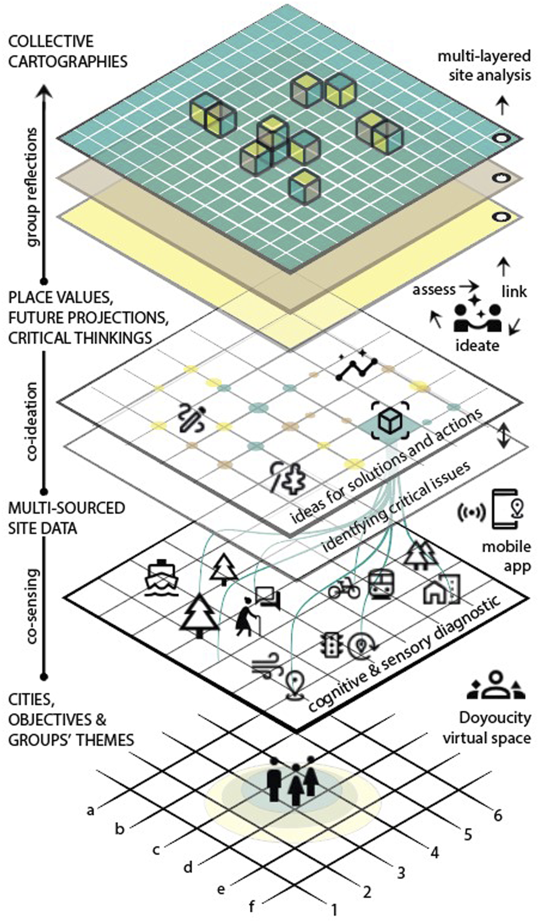
Employed tools
The tools employed within the proposed strategy include a web-based virtual collective space (Doyoucity) and a crowdsourcing mobile app (Fulcrum) for data collection in site analysis, but not limited to them. Additionally, groups employed sensor-based tools (sound and stress meters) for analysis or ideation tools (street mix and gamification) within their objectives.
Doyoucity was developed by a group of researchers and professors from Granada University (including the workshop coordinator). The platform enables users to create projects, collect ideas, rank, and discuss uploaded inputs. We used the virtual space to share pre-workshop materials and disseminate co-creation outputs. Currently, there are 44 projects since 2012 on the platform, and linking users as well as collective experiences in an open space is seen as important (Figure 2). Doyoucity (descriptive pieces of information, geo-locations, partners, and inputs).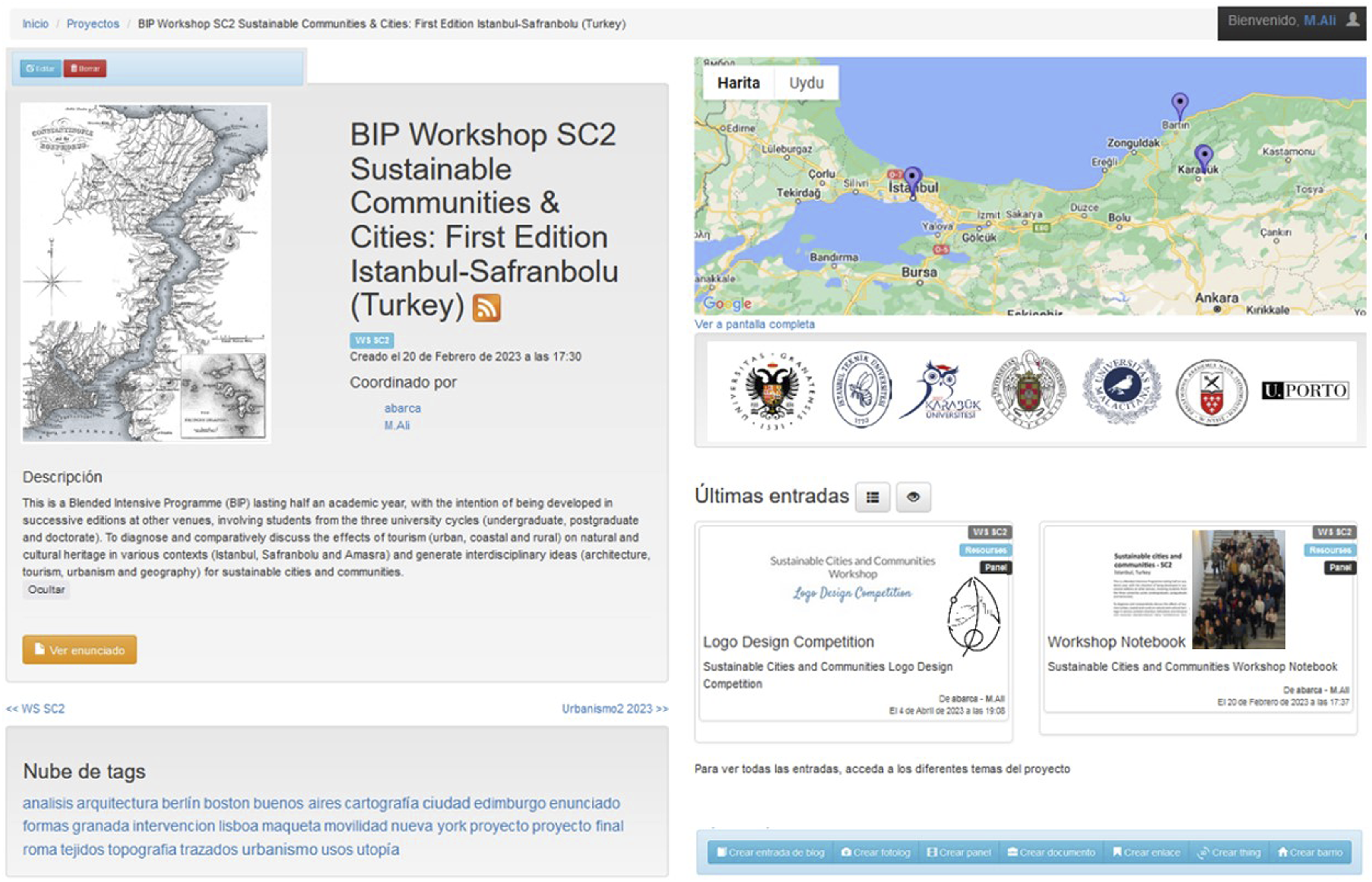
Notably, crowdsourcing applications have gained interest in facilitating coordination and crowd engagement, with researchers and practitioners increasingly using these emerging tools, particularly in participatory GIS and e-participation. These tools encompass web and/or mobile usages, such as ArcGIS, Fulcrum, Ushahidi, Felt, and Emapic, which were employed in previous experiences.26,27 Each has distinct capabilities, differentiating them in the contexts and objectives of site analysis. We used Fulcrum for several critical reasons for this workshop, such as syncretization capability (i.e., continuity to use without Internet access), ease of creating multiple apps for different data collection forms, management team’s access to created apps, projects, and layers, mobile and web usage, and permitted size and types for collected data.
The Fulcrum is used to facilitate coordination, data collection, and sharing during workshops. The platform serves both in physical and virtual workshop periods to increase interactions among participants and between groups and the cities involved. The mobile interface of the platform shows the created apps, a map view of crowdsourced data, and allows for uploading or editing them (Figure 3). Fulcrum mobile use in the workshop.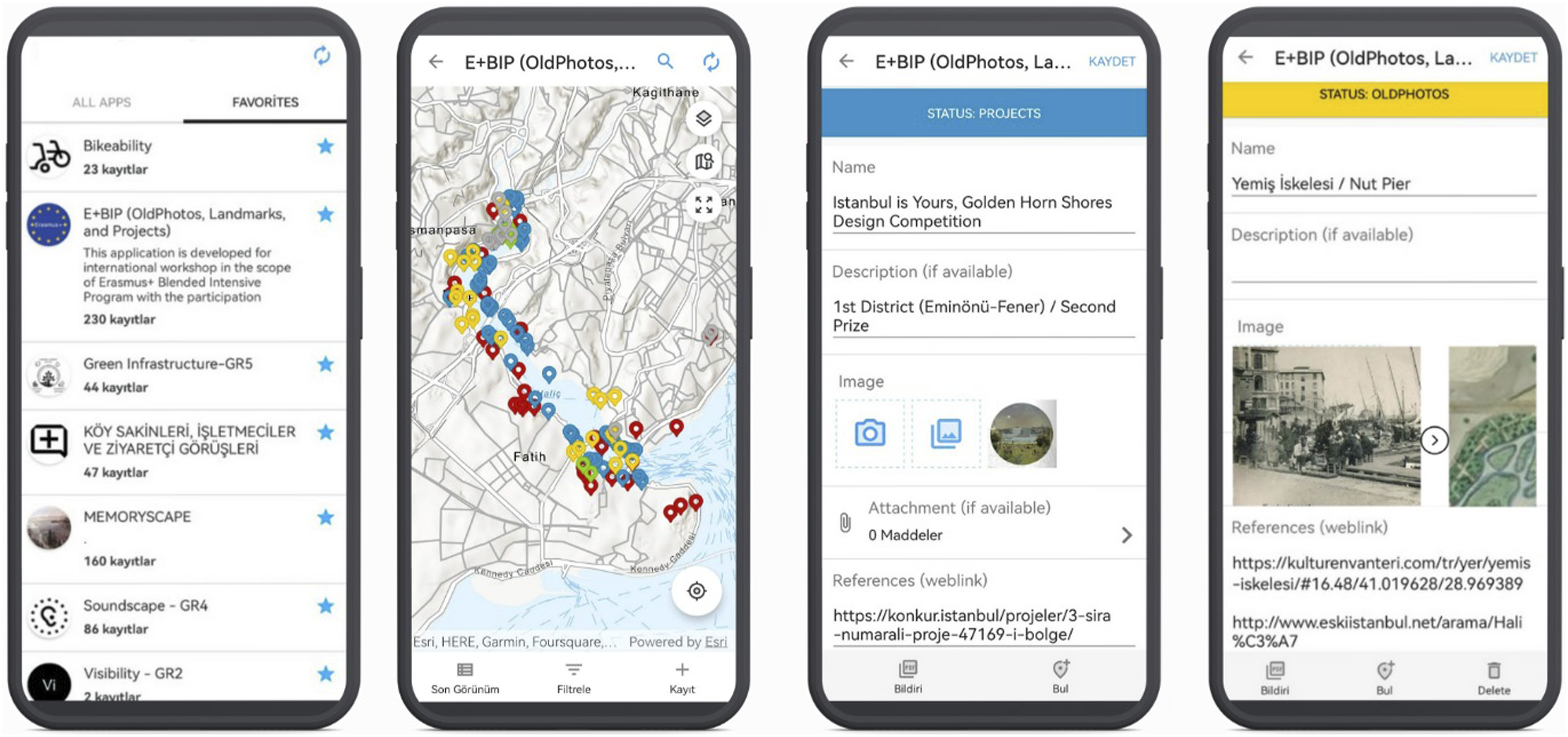
Workshop settings
This research, as a result of an international workshop in İstanbul (April 2023), was funded by Blended Erasmus + Intensive Program with the participation of five universities from Spain, Turkey, Portugal, and Poland. The program spans half an academic year and is designed to be replicated in subsequent editions at different locations. It encompasses 32 students from all three levels (undergraduate, postgraduate, and doctoral) and 14 staff with various backgrounds. Additionally, many experts were involved in virtual sessions with their presentations such as “Principles of n’UNDO”, “Urban Chaos, Democracy’s Greatest Failure, Crises and Natural Rights, the Mar Menor Case,” and “Layers of History: Palimpsest of Analyses of the Golden Horn.”
The workshop's fundamental objective is to collectively generate knowledge addressing urban challenges by embracing nature-based solutions and multisensory spatial dimensions aligned with the UN's 2030 Sustainable Development Goals, with a specific focus on the post-growth paradigm and strong sustainability. We employed a multidisciplinary approach encompassing urban planning, architecture, geography, heritage, information technologies, and tourism. The study areas, Istanbul-Golden Horn, Safranbolu-Old Bazaar, and Amasra-Castle and Harbor, serve as laboratories for collective experiments considering their variations in terms of urban features, chronic problems, and different levels of complexities and scales.
The five working groups were created according to the expertise of participants to address issues from multiple perspectives. Each group, centered around a theme related to sustainability dimensions consists of one or two students from each university. The themes were collectively defined in virtual sessions and include memory scape, visibility and image, bikeability, stresscape, as well as green infrastructure and biodiversity.
Results
This section is structured around the process and outcomes of co-sensing and co-ideation. The initial part involves extensive fieldwork, wherein groups delineate their tactical paths for diagnosis employing crowdsourcing and sensory tools. Each group concentrates on specific challenges pertinent to their respective themes. Subsequently, the identified critical issues are deliberated upon, along with proposed solutions by the groups.
Co-sensing
We presented three tactical trajectories within the diagnosis, focusing on the interconnected themes of bikeability, stresscape, and visibility.
Bikeability is measured based on the suitability of infrastructure elements for bicycle use, such as the effectiveness of bicycle routes (bikeways, shared roads, road lines, signs and markers, and lighting), parking lots, interaction with motor vehicle traffic, topography, relationship to green areas, and an individual's ability and desire to ride a bicycle. 32
In addition, cyclists’ route selection preferences and behaviors are multidimensional and complex. Bicycle users consider distance, number of crossroads, bicycle stations, and safety, according to empirical studies on the use of bicycles and route selection.33–35 It is of the utmost importance to analyze physical and behavioral factors that influence route selection in detailed transportation models and to devise new strategies for reshaping new routes in light of these factors.
The bikeability group employed the crowdsourcing application Fulcrum to conduct a multi-criteria analysis on-site. Within this context, the route was divided into six sections. The group members rode their bikes in each section and evaluated the survey. The survey asked them to answer the questions and rate the criteria related to physical, environmental, and visual factors. The integration scores were calculated depending on the bicyclists’ answers and ratings,
36
as well as an analysis of crowdsourced images to underscore perceived barriers (Figure 4). Bikeability through multi-criteria analysis in the Golden Horn/İstanbul.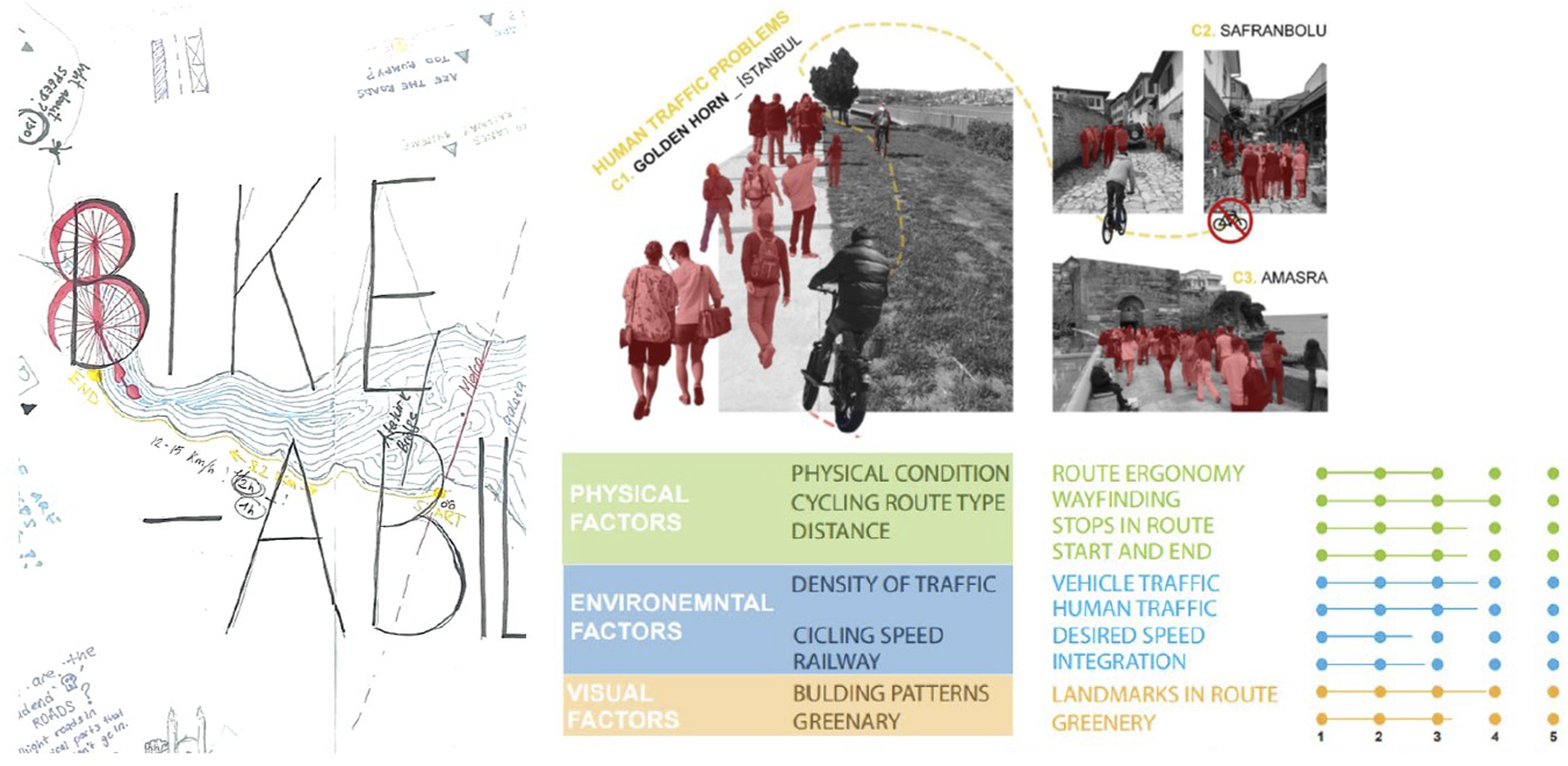
Stressscape was measured through multi-sensor data collection. Galvanic Skin Response (GSR) type sensor-based tools have been shown by academia to be useful tools for monitoring activities, with significant increases in skin conductance observed in response to emotional,36,37 fear, 38 or stress situations. 39 The identification of such effects, and of the situations that cause them in the urban space, is a field of experimentation and urban analysis, while also offering a remarkable learning opportunity.
In the workshop, these information-gathering techniques were applied using a Neulog sensor system, integrating GSR NUL-217, sound sensor NUL-212, and a GPS NUL-243. The studies conducted with students clearly identified significantly lower GSR data in areas surrounding green open spaces and parks, as opposed to urban areas with high road traffic, where stress levels were significantly higher (Figure 5). The GSR equipment proved to be comfortable and efficient in data collection, even in experiments lasting more than 1 h. However, it was planned to integrate portable Electroencephalography (EEG) equipment (Emotiv EPOC+), for the identification of other emotions, its complexity and practical drawbacks (need for sensor hydration, etc.) prevented its effective application. Stressscape analysis through multi-sensor data collection for Golden Horn/İstanbul.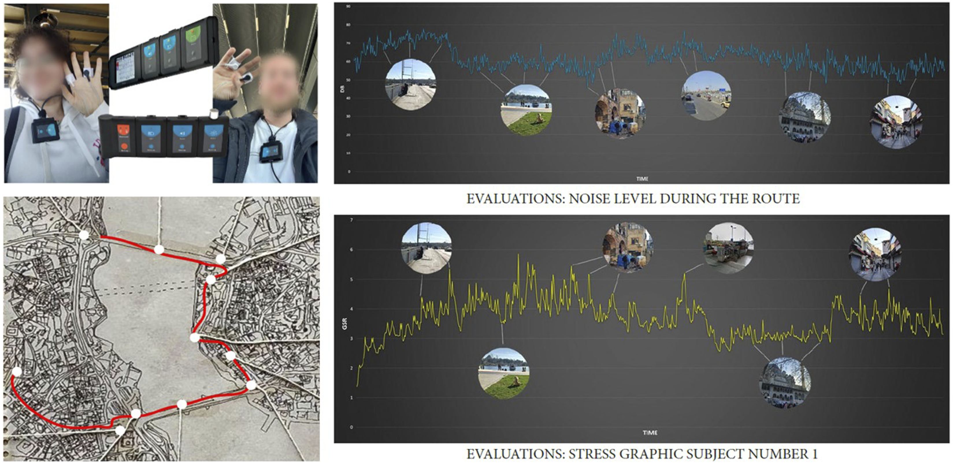
Visibility and image of a city result from the overlap of many individual images, or the image of a place is widely shared, since the image involves a dual process between observer and observed. 28 Designers frequently lean on their implicit values and perceptions, yet Lynch underscores that the understanding starts with users’ images and priorities.
In Arturo, similar to the strategy presented in Singapore’s Pavilion, people are viewed as sources of opinions based on subjective perceptions of evaluation images. These opinions are then employed to train an algorithm and establish measurable criteria for livability. SenseCityVity, encapsulated in its slogan “observe, sense, and share,” adopts a similar approach but in a reversed flow—collecting images from people and transforming them into knowledge using machine learning techniques to discern certain dimensions of the urban environment. CoastSnap differentiates by involving civic auditing for coastal changes, achieved through crowdsourcing images from camera cradles or stations located in predefined areas.
The visibility group focused on differentiating between users’ perceptions across sites and temporalities, drawing from Lynch's concepts of imageability and sensibility. This encompassed diverse users including tourists and children, as well as scenarios like narrow visibility experienced while using an umbrella or a wide view (Figure 6). Differences were noted across the three cities, spanning streets, centers, and coastlines, where distinct dominant, harmonious, and controversial relationships emerged. These were influenced by factors such as centrality, tourism, historical significance of the area, topography, street animals, and various other elements. However, the most intriguing aspect lies in the varying perceptions that arise based on different viewpoints on the same path. While these different viewpoints were explored in four forms, they can be further extended through numerous combinations in our perceptual world. Visibility analysis through tourist, narrow, child, and wide viewpoints in Amasra/Bartın.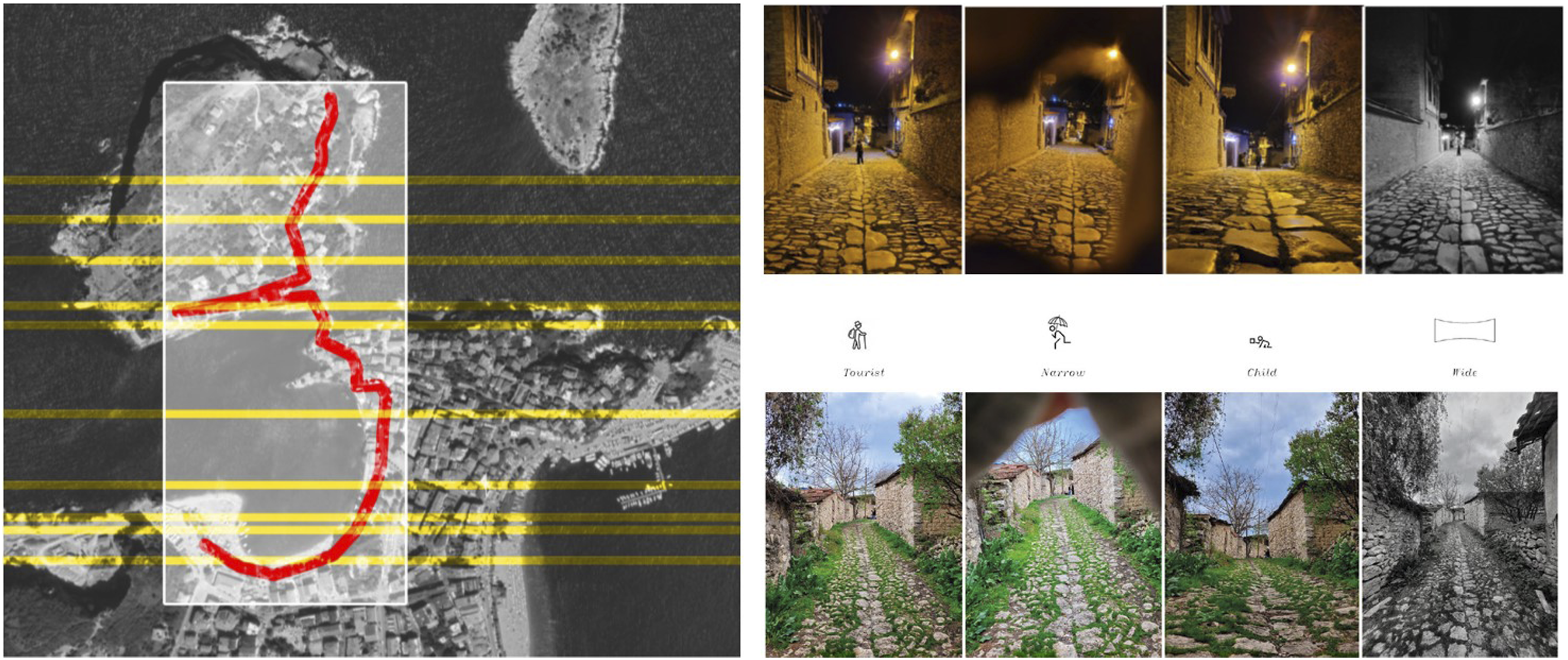
The features we perceived during site analysis present multiple perspectives, and they are not limited to the three dimensions exemplified above. Memoryscape and green infrastructure groups employed crowdsourcing applications to capture critical issues, both human and non-human behaviors, and physical features within the sites. By embracing “dériva,” these groups delved into the immersive flow of everyday life.
Co-ideation
The follow-up stage relies on interpreting and linking the collective experiments’ productions and processes. Depending on the groups’ approaches, data-driven, comparative and imaginative explorations result in diverse productions through the utilization of collages, affinity diagrams, before-after illustrations, chronograms of transformation, sociograms, urban propaganda, schemas, and sketches across three cities. All these ideations are either physically pinned or digitally represented on collective cartographies to facilitate critical thinking, make visible the values of the places, disseminate ideas for solutions, and draw future projections.
Carved into a Val Camonica rock, an ancient map portrays life in a Paleolithic village and its intricate network of paths, including activities, footpaths, huts, and livestock areas in the territory.
30
Similarly, the collective cartographies include diverse perceptual elements of everyday life: people engaged in activities, waterfronts, cityscapes, street patterns, monuments, flora, and more (Figure 7). Diverse productions and collective cartographies.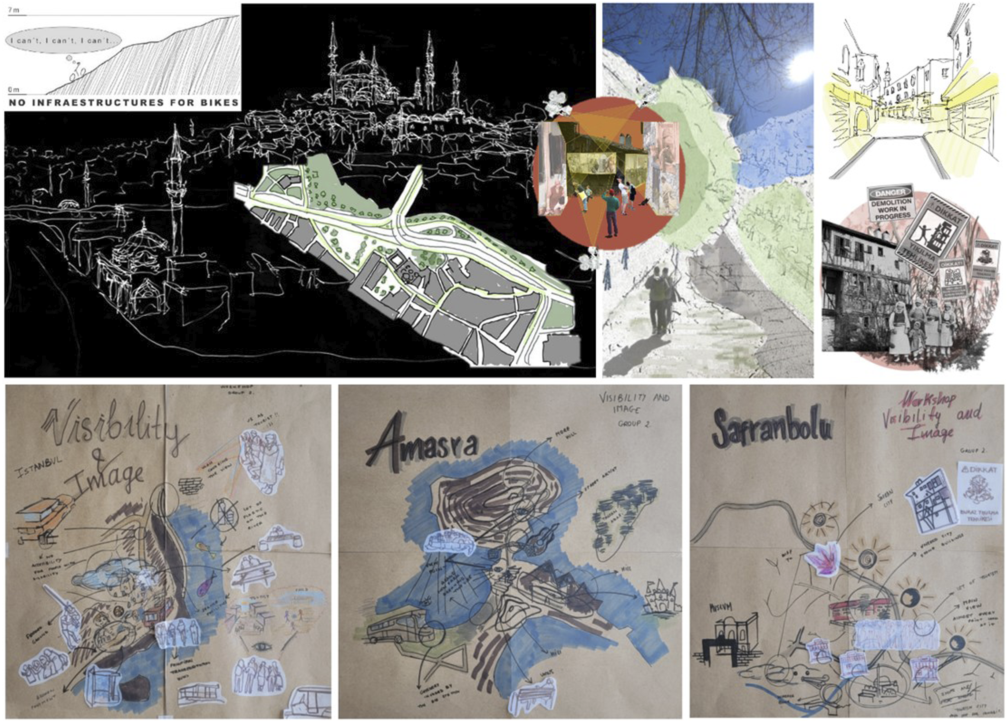
The utilization of digital and physical tools depends on the decisions made by the groups. Both of these tools are employed in the co-ideation process. When we consider a more comparable example, such as street designs (Figure 8), sketching offers a creative space and flexibility for incorporating elements like sound barriers and solar panels, which are not available in the digital tool used by the other group. In contrast, the digital tool (Streetmix) offers an analytical and rapid way to configure street design. Nevertheless, it is essential to note that the advantages and disadvantages of these digital/analog tools are context-dependent. Sketching and Streetmix app for the street design by two different groups.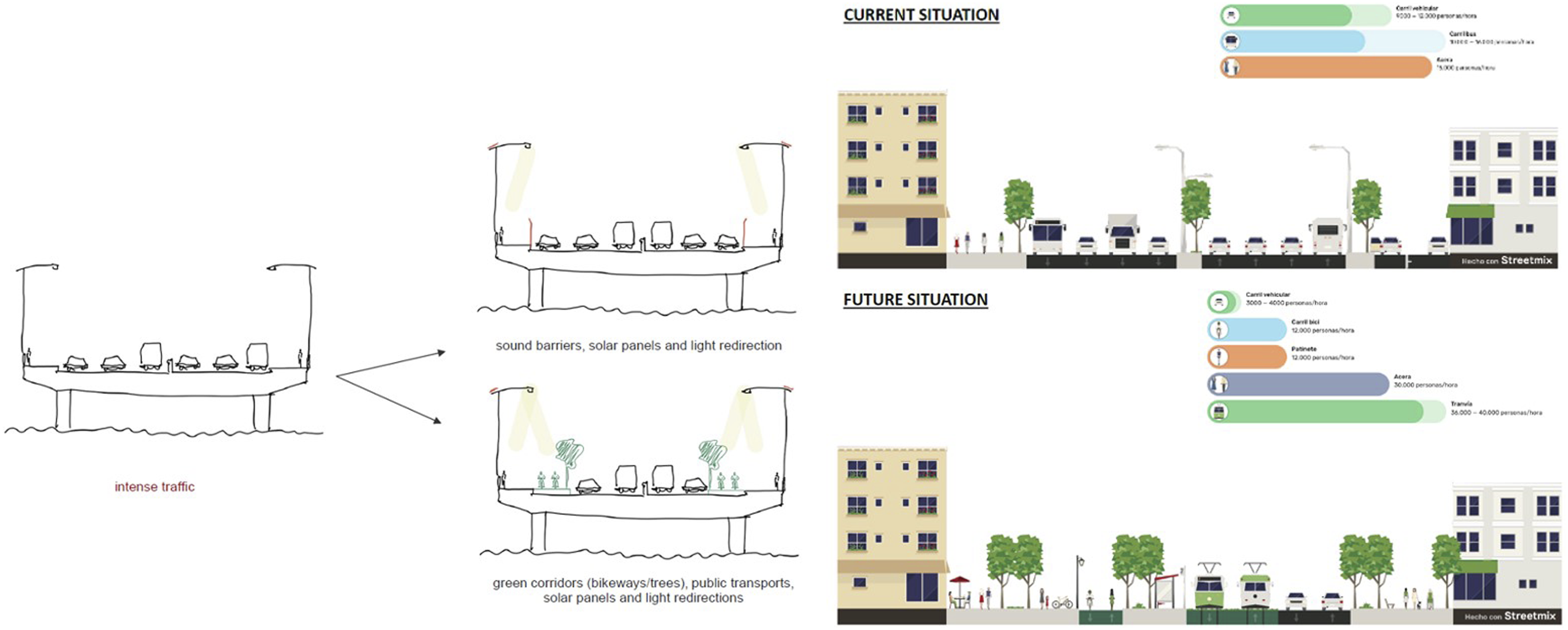
Another noteworthy result is the robust interaction patterns that emerged both within and between the groups in the workspace. The presence of participants from various universities and professors with diverse expertise further enriched this interactive environment. The tactical trajectories generated by the groups during their site analysis and studio activities contributed significantly to the co-ideation process, enabling them to effectively explore the sites in a versatile and interactive manner.
Moreover, the inclusion of seminars, joint activities, and competitions organized to represent the workshop theme further fostered collaboration and interaction among participants. The crowdsourcing applications utilized by each group facilitated the access, recall, and interaction with multiple data points, including site perception, diagnosis, historical photos, maps, government-led projects, and landmarks, across different themes and cities. In summary, group diversity catalyzed creative solutions discussed collectively in the shared workspace.
Participants with diverse skills within the group can further develop these co-ideations in smaller micro-groups of two or three individuals, and specific micro-tasks are assigned to them. For instance, in the Stresscape group's studio process, tasks encompass visualizing sensor data, analyzing crowdsourced information, identifying critical concerns, exploring relevant solution concepts, illustrating proposals using tools such as sketches and diagrams, and creating routes and materials for cartographical purposes (see Figure 9). While these task descriptions primarily revolve around assessing field data, identifying vital/critical aspects, and proposing solutions, they offer flexibility to accommodate various group interests and specific goals. Group interactions during crafting, sketching, decision-making, and presenting ideas.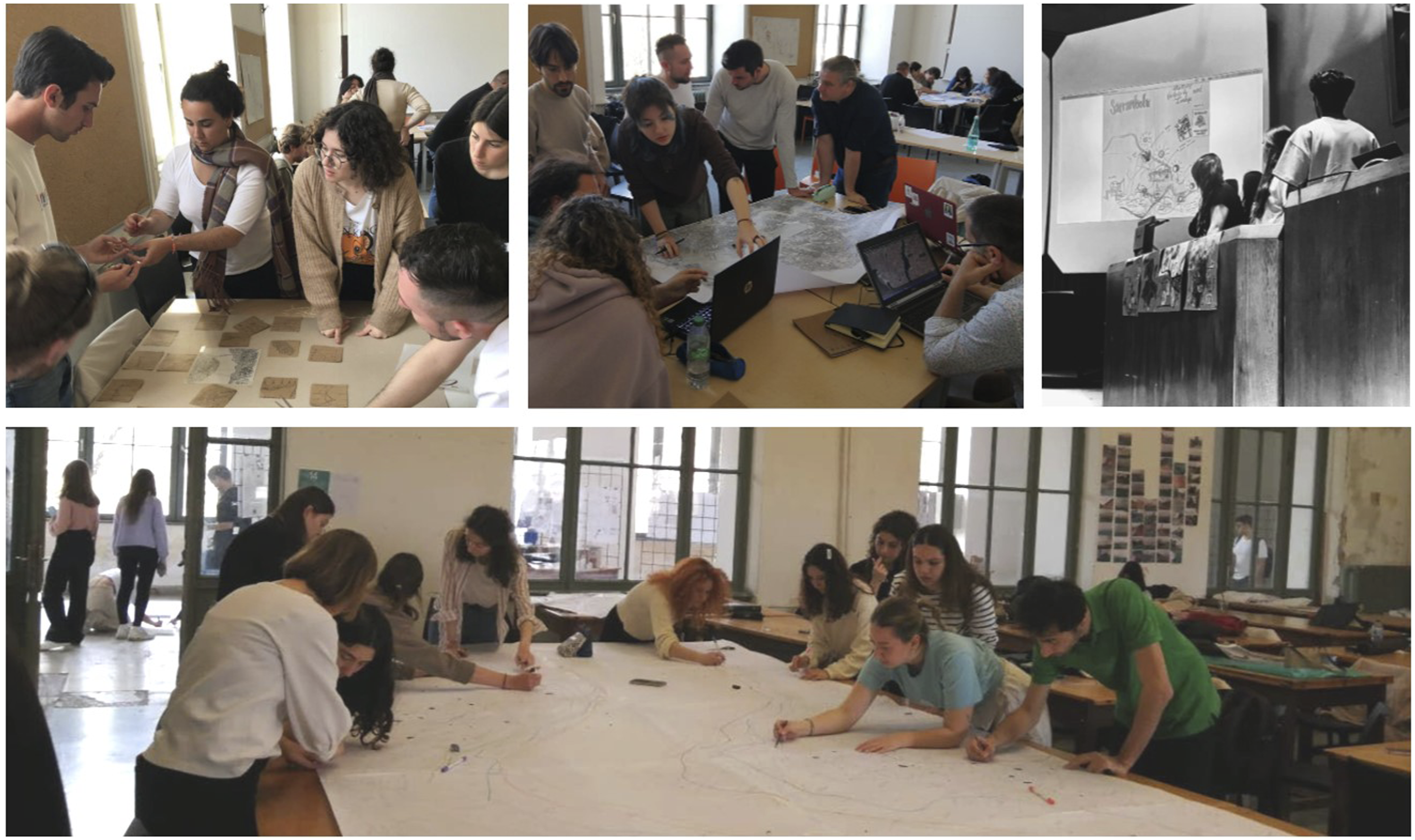
Discussion
Under the RQ framework, research findings are discussed via the proposed strategy, self-generated tactics, and student evaluations. The CC strategy is comparatively examined alongside other novel crowdsourcing methods, evaluating its potential and limitations. Furthermore, group-generated tactics and their contexts are elaborated upon. Finally, workshop objectives, virtual and physical processes, joint activities, utility of CC, usability of mobile/web app, achieved goals, and outcomes are discussed based on student reflections.
Leveraging CI from aggregation to Co-creation
What are the benefits of existing crowdsourcing strategies for urban design, and how does our proposed strategy offer distinct contributions?
In the introduction, we emphasized two distinct CI approaches, akin to Arnstein's well-known ladder of participation, each characterized by its degree of crowd empowerment. Given the numerous existing cases to be assessed within this context, our selection was conducted with the consideration of their relevance to urban sensing, mediums, methods, and objectives. A comparative analysis of these crowdsourcing applications can shed light on the diverse mechanisms.
Desirable Streets, analyzes walking experiences to create a desirability index from GPS data, while the SocialGlass platform integrates diverse geo-social data for real-time city monitoring, including user demographics and social activities. 40 These crowdsourcing methods track urban behavior patterns across different spatial and temporal scales, falling into the aggregation.
Arturo, SenseCityVity, and Coastsnap underscore the perception of certain environmental dimensions through images. Although these strategies extract people's opinions, the unilateral CI mechanism primarily relies on the individual activities of the crowd. Overall, the exemplified aggregation approaches mostly deal with large-scale areas such as metropolitan or regional issues and aim to generate measurable and comparable knowledge from a large amounts of perceptional data. Nevertheless, the potential for contributing to societal awareness through informative cradles in CoastSnap and mutual learning via group interactions and collective actions in SenseCityVity can be associated with co-creation.
Platforms like Decide Madrid (2015) and various other government-led digital platforms have played a significant role in facilitating citizen engagement. These platforms enable individuals to voice their opinions and vote on proposed budget allocations. While Decide Madrid was recognized with the UN prize for the best public service in 2018, recent data from the municipal portal 41 indicate a significant decline in its usage and lower visitation rates. Interestingly, a similar budgeting platform called “Bütçem İstanbul” (2022) has recently been introduced in Istanbul. One of the key highlights of this workshop is the diversity of participants from various universities, including the Complutense University of Madrid and the Istanbul Technical University. The Biodiversity group, which aimed to design participatory and nature-based innovations in Istanbul, drew inspiration from best practices. In this context, government-led budgeting platforms (Decide Madrid and Bütçem İstanbul) were also analyzed.
Another engagement strategy is gamification, as exemplified by the video game SuperBarrio. This approach gathers citizens’ opinions from game outputs and also serves as a tool to raise awareness by illustrating the multidimensional impacts of each in-game decision. It further facilitates neighborhood participation in the design process, allowing citizens to envision new superblocks. The Habla app 42 also employs an augmented reality (AR)-based participatory design game. Users can add comments and emojis related to their neighborhood, exploring all open contributions on maps and through AR views. These mobile applications demonstrate the possibilities within digital and playful co-creation settings that also allow for asynchronous collaboration. In the web-based Qua-Kit (Quick Urban Analysis Kit), non-experts are encouraged to participate in given design scenarios through 3D manipulations and discussions. 43
In 2020, the Municipality of Istanbul initiated a web-based design-focused participatory mapping project centered around the Kabataş Transfer Center. With the goal of generating a conceptual design based on user proposals, this project engaged a total of 348 participants. 44 The application gathered spatial preferences from participants using a 2D digital map, collected data by relying on individual activities, and then interpreted this through overlapping and statistical analysis. However, unlike applications Habla, Qua-Kit, and SuperBarrio, this project did not facilitate dialogue among participants. Additionally, it did not provide opportunities to illustrate the impacts of individual decisions to raise awareness.
Ranging from co-sensing to co-creation, crowdsourcing design strategies encompass citizen kits, crowdsourcing applications, feminist human–computer interaction, civic media, and web-based social platforms. Given the dynamic and pluralistic nature of co-creation in design, it becomes crucial to embrace a well-structured strategy that promotes interaction, openness, empowerment, and collaboration in alignment with the objectives. Oxman and Gu posit that crowdsourcing, diverging from traditional hierarchical co-design models, represents a promising concept in distributed, collective, and open design processes. 45 The effectiveness of crowdsourcing-based approaches in collaboratively generating architectural artefacts is also confirmed by Dortheimer et al. 46
In our context, the CC strategy, augmented by crowdsourcing applications and virtual platforms, was employed to collect on-site perceptual data and facilitate co-ideation. The interconnected contributions can be articulated as follows: 1. The co-creation of cartographies involves a reflective process and incorporates multiple perspectives of individuals. 2. Cartographic workspace, whether in digital or physical forms, fosters critical and divergent thinking by drawing from everyday experiences and challenging dominant narratives. 3. Legible and ludic cartographic representations encourage active participation in the project from non-expert and diverse groups, including children, the elderly, disabled individuals, and youth. 4. Multi-layered cartographic creations can reveal contested knowledge about territories, incorporating measurable, perceivable, and comparable information. 5. Micro-tasks can enhance the co-creation mechanism through various means, including crafting, modelling, modifying, removing, grouping, and linking data, ideas, and decisions. 6. Shared co-creation settings provide a social interaction and mutual learning ecosystem, harnessing the diversity of groups and disciplines. 7. Abstracted cartography renders multi-sensor data visible and contextualizes various representations, from affinity diagrams to design sketches. 8. Mapping is adaptable to any scale, ranging from neighborhoods to metropolitan areas, or even cognitive and critical maps with a flexible scale. 9. The materials are inexpensive and readily accessible, whether in a village or in the city center. 10. It enables improvisation and the emergence of new tactics, allowing for the real-time incorporation of group manoeuvres.
Antonio and Horrillo employ mapping as a means to facilitate dissemination, consensus-building, and creating new narratives. 47 They combine dialogues and interconnected reflections to achieve these objectives. Elovaara and Mörtberg utilize mapping methods to “provide space for situated, partial, and multiple ways of knowing” in their workshops. 48
Overall, these innovations herald a paradigm shift by offering novel avenues for augmented civic participation, creative crowdsourcing, co-sensing, and engaging the senses in urban space design.
Self-generation of tactical trajectories
To what extent did the self-generated tactics influence the co-creation process and its outcome, and what factors can promote or impede them?
Besides the contributions of the proposed strategy, we have encountered limitations. The first limitation relates to time constraints for site analysis and group proposals, which arose due to the intensive program across three different cities. “Our brief journey across sites generated unique yet interconnected insights, highlighting our effective collaboration within a limited timeframe” as noted in participants’ reflections. Greenbaum and Loi use the metaphor of participation as a camel (and even an elephant), portraying it as an elegant animal with numerous practical uses, yet acknowledging its inherent complexity, messiness, and slower pace. 49 Due to this complexity, several promising ideas, such as projection mapping to enrich cartographies, portable EEG equipment to enhance sensibility, and Latour's game “where to land?” for group reflection, were suggested but could not be integrated into the workshop process. However, this complexity also led to the emergence of new approaches through collective wisdom. Our exploration into these emergent strategies forms the basis of our second research question.
We believe that the tactical trajectories further expand these contributions, providing additional benefits and broadening the manoeuvring space to address issues during collaboration. By incorporating agile principles and fostering self-organization in collaboration, we deliberately refrained from providing specific procedures to be followed during the workshop. Instead, we outlined general and flexible guidelines along with a schedule. Moreover, the distributed collaboration through the micro-groups in the co-creation process is also effective in generating new tactics due to its diversity, independence, and versatile interaction within and between groups.
The tactics generated by groups exhibit variations influenced by factors such as time constraints, addressed issues, specific group objectives, diversity within the group, skillsets, and contextual circumstances. We understand that these tactical trajectories differ across groups. For instance, the overarching theme initially identified in virtual sessions to be “accessibility” has been refined to focus on “bikeability” through group consensus. Similarly, the theme initially designated as “soundscape” evolved into “stresscape.” These changes were primarily due to the limited time available, which did not allow for an extensive and in-depth analysis of broad subjects. Another interesting tactic involved gamifying visibility and image through a card game, using images from three cities.
The memoryscape group transformed the mobile application (Fulcrum) and expanded its use from a diagnostic tool to a learning tool by collaboratively adding helpful information in advance. This information included old photos and maps (mainly by Pervitich and others), current project renders, and critical landmarks of study areas. This collaborative effort arose from the need to become familiar with the study areas during the virtual period, as participants were unfamiliar with the cities. Fulcrum generally served as a shared virtual interaction space with apps created according to the groups’ data collection forms. However, technical issues were reported, such as data loss during data synchronization while collecting data on-site. To mitigate these risks, it is crucial to test the mobile app and inform participants to ensure periodic backups.
In addition to the general site trips for all the groups to introduce cities, each group organized their route-driven or “derive” trips for site analysis. In the virtual sessions, nearly every group initially planned to analyze three sites. However, during the physical activities, the groups’ focus diverged based on the connections between urban features and the addressed issues.
Another limitation is the impracticality of conducting a citizen survey due to the language barrier. The majority of participants are not proficient in Turkish, even though each group includes one or two local students.
The biodiversity group also extracted principles from cases related to renaturalization and desurbanization of over-urbanized areas in addressed cities. They particularly emphasized the ecological perspective and eco-social transition in the context of the global crisis. As Latour repeatedly emphasizes, “everything is a society,” encompassing entities such as ants, bacteria, cells, or scientific paradigms. 50 In a broader context, it's essential to consider the involvement of non-humans within an inclusive network. Sensors, especially, can serve as a medium to “make them talk,” 29 thereby rendering “invisible actors more visible” 51 and “relating to more-than-human concerns” 52 in the participatory design process. While CI tools are primarily deployed to address urban challenges by merging technology, data, and human input, 13 this is done with an anthropocentric concern. However, incorporating non-human entities into participatory design and urbanism offers a new avenue from an ecocentric perspective.
As a result, the tactical trajectories play a crucial role in unfolding the co-creation process and making a significant contribution to the overall collaboration and objectives. However, participants' reflections clarify these statements and various others.
Participants’ reflections
What are the participants' overall evaluations of, and reflections on, the workshop?
Arniani et al. underscore that the core of CI success lies in human motivation, engagement, and contribution to the process, albeit augmented by technology. 20 The last stage in our action research method is “reflection” to determine negative aspects and improve them by modifying or changing the strategy. Therefore, we conducted an analysis of the participants’ (Ps) evaluations and reflections.
Regarding the organization, activities, objectives, and the achieved results, the evaluations are significantly positive. P1 student from the Heritage and Memoryscape group reflects:“This workshop has expanded my knowledge through various multidisciplinary practices within different contexts in architecture and urbanism. We had the chance to study a paradigmatic city with many underlying layers, the palimpsest personification. Luckily unlike many theoretical workshops, we prioritised the site visit and subsequent analysis… Immersed in an unfamiliar landscape, we had the chance to explore and study Heritage and its integration within the city, topography, and culture. While having distinguished positions, dynamic conversation supported each group’s discourse. Surprisingly, the unique mixture of voices and backgrounds composed provocative thoughts. Within 1 week, the result presented how distinct narratives within each theme approached the Golden Horn and the Built Environment.”
The reflections clearly vary among theme-based groups. P2 student from the Stresscape group reflects: “Our team engaged in a comprehensive discussion regarding the concepts of soundscape and stresscape within the context of Turkey. Our exploration delved into various facets of sound, differentiating between their types and assessing the influence of diverse factors such as familiarity, age, gender, and time of day on perceptual experiences. This led us to an intriguing observation: stress can manifest through contrasting reactions, evident in scenarios such as densely populated locales versus sparsely populated ones, illumination versus darkness, and the interplay between noise and silence. Drawing from personal encounters, I utilized a stressometer to quantify my stress levels. The resulting graphical representation unveiled noteworthy patterns, prominently highlighting instances of heightened stress clustered around areas with heavy vehicular traffic and exceptionally loud auditory stimuli.”
However, there are also negative points that have been raised. One concerns the limited guidance from the group tutors and a perceived lack of freedom in discussions. Additionally, some participants have criticized the shifting of specific objectives based on group decisions, noting that this has led to a disconnect between the academic outcomes and the originally intended objectives. Another negative aspect involves the management of site analysis, the intensity of the program, and a desire for more opportunities for common group reflections.
The evaluation of group diversity, participating students, and professors is also overwhelmingly positive. Collaborating within theme-based groups is highly rated, with 23% very satisfied, 62% satisfied, and 15% neutral responses. The level of interaction between groups is generally positive, with 8% very satisfied, 54% satisfied, 23% neutral, and 15% dissatisfied responses, suggesting room for improvement. The evaluation of the CC strategy is very positive, with 31% very satisfied, 62% satisfied, and 7% neutral responses. The utility of the crowdsourcing application is also positively evaluated and rates higher than the usability of Fulcrum. For example, one participant noted, “The workshop allowed us to experience various presentation techniques and tools. The methods of conveying information that were used are valuable in improving my own communication and collaboration skills.” By utilizing the PGUS usability scale, 53 we conducted a comparative analysis of the usability of several applications, including Fulcrum, Felt, Emapic, and Ushahidi, in previously conducted research. 26
Conclusion
The CC strategy developed within the scope of the research offers promising results from co-sensing to co-ideation. Within a limited time frame, it enables the examination of highly complex areas in three different cities through various themes and facilitates inclusive, playful, and distributed collaboration for idea generation aimed at creating a sustainable and multisensorial environment. The proposed strategy stands out for its ease of implementation, adaptability to different contexts, integration with digital and physical tools, exchange of real-time contextualized knowledge, and an interactive structure that allows multiple individuals to collaborate together in our specific context.
On the other hand, where the strategy has not been clearly defined or has fallen insufficient, or when it has not been embraced by the group, tactical trajectories have emerged and diversified the collaborative process. Particularly, the reasonings of these tactics have been examined through groups. It has been observed that shared activities, group diversity, distributed collaboration, interaction between groups, and competition have had a positive impact on co-creation. Theme-based mixed groups also foster “distinct narratives within each theme” and contribute to mutual learning in the context of an interdisciplinary workshop. Student reflections reveal the diverse perspectives within the co-creation process, expressed as “multidisciplinary, multilayered, multidimensional, and multisensorial.”
From an academic perspective, the workshop—as also evident in this paper—lacked reflection in the ideology/paradigm section (as per Meadows, 54 which is something that architects are often blamed for; doing without thinking, akin to unnecessary construction. CI, in general, should be geared towards reflection rather than mere action (the act itself is not the essential part, but rather the collectivity). The collective, as a systemic activity rooted in reflection, makes sense in addressing the global (and chronic) systemic crisis, as well as addressing the specific crises within the fields of architecture and urban planning. It aims to make these disciplines more democratic, pluralistic, open, flexible, reversible, transdisciplinary, cross-cutting, and, of course, ecocentric.
As the research progresses, many points, such as cognitive processes, pedagogical aspects, perceptual factors, tactic promoters, and interaction patterns, mostly remain undiscovered. The plan is to develop and refine the reflective aspect, with a focus on The Darro River Valley in the second edition of the workshop in Granada. In this context, each ongoing action circle will unveil new tactical trajectories, narratives, reappropriations, controversies, and comparable outcomes to better understand the dynamics of co-creation, particularly in complex urban spaces.
Footnotes
Acknowledgements
We thank all participants and collaborators for their great contributions; Assoc. Prof. Dr Demet Arslan DİNÇAY, Prof. Dr Aysun ÖZKÖSE, Prof. Dr Agata PİET, Prof. Dr Piotr OPALKA, Prof. Dr João Rodrigo PARREİRA COELHO, Prof. Dr Ana Silva FERNANDES, Prof. Dr Yolanda ROMERO, Prof. Dr Rubén MORA, Prof. Elena ENCISO, Assoc. Prof. Dr Fernando Osuna PÉREZ, Res. Asst Ecem Karabay, Res. Asst Emre KARATAŞ, Ezel Yağmur Çebi OKUMUŞ, Prof. Teresa Vicente, Veronica Sánchez Carrera, and Andrés Rubio.
Declaration of conflicting interests
The author(s) declared no potential conflicts of interest with respect to the research, authorship, and/or publication of this article.
Funding
The author(s) disclosed receipt of the following financial support for the research, authorship, and/or publication of this article: This study has been funded by Erasmus + Intensive Program with the coordinatorship of Granada University. Project Code: 2021-1-ES01-KA131-HED-000006973-5. This research was conducted in the scope of PhD thesis with financial support from the Scientific and Technological Research Council of Turkey (TUBITAK) BIDEB-2214/A International Research Fellowship Program (1059B142100330).