



Abstract
This article analyzes the connection between public school segregation and Urban Renewal and interstate highway construction in Birmingham, Alabama. It analyzes the routes of the interstate highways, the locations of Urban Renewal areas, and their impact on segregated schools and school zones. This article argues that interstate highways and Urban Renewal were used to preserve segregated schools. It also argues that activists for White schools were able to affect interstate highway design while activists for African American schools were not. Also, Urban Renewal funds were used to build new segregated schools and neighborhoods in order to reinforce patterns of segregation.
This article analyzes the impact of interstate highway construction and the federal Urban Renewal Program in Birmingham, Alabama, on segregated public schools during the civil rights era. 1 The goal of this article is to understand the link between school segregation in Birmingham and the development of the interstate highways and Urban Renewal in the city. The overall argument is that the interstate highways and the Urban Renewal Program were used to keep schools segregated in the face of court desegregation orders in Birmingham.
Birmingham is the largest city in Alabama and is well-known for its tumultuous civil rights history. Research has documented the impacts of interstate highways and Urban Renewal projects on African American people and neighborhoods in Birmingham. Research has also chronicled the practice of public officials in Alabama of deliberately locating highways and Urban Renewal projects in African American neighborhoods. At the same time, school desegregation battles and the resistance of public officials to court desegregation orders in Birmingham has also been well-documented. Therefore, Birmingham is a good setting for this analysis because this article contributes to both of those threads of research, connects the two, and explores the effects of Urban Renewal and interstate highways on schools and school desegregation.
The major contribution of this article is the analysis of the relationship between school segregation, Urban Renewal, and interstate highways, which is an area of scholarship that has not been fully explored. The analysis identifies three ways that school segregation was impacted by interstate highways and Urban Renewal. First, it identifies inequalities in the response from White public officials to concerns about the impacts of interstate highway construction on public schools—White activists received more accommodations to their concerns than African American activists, resulting in more school inequality. Second, the analysis identifies instances of Urban Renewal funding that was used to construct new African American schools, in order to avoid zoning African American schoolchildren to nearby White schools in the face of school integration court orders. Third, this analysis identifies cases of Urban Renewal funds that were used to demolish African American homes that were located in racially mixed neighborhoods zoned for White schools, in order to avoid zoning African American children to White schools.
The first part of this article discusses the context of the US Interstate Highway System and Urban Renewal Program nationally and in Birmingham, and school desegregation in Birmingham. The second part of this article is an analysis of the archival documentation relating to public schools in the path of the planned routes of the interstate highways in Birmingham and in Urban Renewal areas in the city, organized in three major themes. First, African American homes in racially mixed neighborhoods that were demolished to allow White schools to draw from White neighborhoods. Second, schools that existed before the construction of the interstate highways for which activists sought mitigation from the negative impacts of the interstates. Third, African American schools that were constructed near existing White schools using Urban Renewal funds to maintain segregation. The final section presents an assessment and conclusions about the relationship between school segregation to interstate highways and Urban Renewal in Birmingham.
Interstate Highway Construction and Urban Renewal in Birmingham
The interstate highway construction era began slowly, with a long history of support from engineers, the trucking industry, and motorists. By the 1930s, some limited access roads had been constructed in the United States. In 1939, the US Bureau of Public Roads (BPR) released the study recommending a 33,920-mile interstate highway system that connected most major cities with a population over 100,000. 2 Highway Acts in 1944, 1952, and 1954 added more miles to the system. In 1956, the Interstate Defense Highway Act allocated 90 percent of the construction costs for the interstate highway system to the federal government, along with taxes on gas, licenses, and tires. 3
Early in the interstate highway era, highway engineers sought to distance themselves from politics and claimed that interstate routing was a technical process, based on distribution of population, motor vehicle ownership, and traffic. In reality, however, highway routing was a highly political process, and the technical decisions of highway engineers were political choices. Throughout the 1950s, routing choices were made by highway engineers in conjunction with political leaders. 4
When the initial interstate highway routes in Alabama were announced in 1955, most of the major urban areas in the state would be located near a highway. As was common in other states, the proposed routes would bypass major urban areas with a connector spur into the downtown area for highway access. One exception to this design was Birmingham, however. Birmingham was the only city in Alabama in the Yellow Book—the book that contained the proposed routes through urban areas—that had most of its interstate highway system running directly though the city (Figure 1). 5 However, after announcing the initial highway routes, BPR began to run highways more directly through cities, due to lobbying from urban mayors and governors. 6

Initial proposed routes of the interstate highways in Birmingham. Source: US Department of Commerce, Bureau of Public Roads, General Location of National System of Interstate Highways (Washington, DC: Bureau of Public Roads, September 1955), Interstate Planning and Designation Files, RG 406, Entry UD 06D1E.06, Stack 130, Row 28, Compartment 33-, Shelf 3-4, Box 8, National Archives II in College Park, Maryland.
When the proposed interstate highways were rerouted through urban areas, state departments of transportation began to play an increasingly important role in route designation and design. Because urban expressways would serve local traffic needs as well as the needs of interstate traffic, they had to be incorporated and planned with current and future land use, other modes of transportation, and the existing urban street design. 7 State highway directors and their engineering staff became primarily responsible for urban interstate route design and made very important routing decisions. BPR maintained final authority for approving highway routes although they typically approved state route choices because they were reluctant to question state highway departments, who had more local knowledge than BPR. 8
The Alabama Highway Department (AHD, now the Alabama Department of Transportation), like many public agencies in Alabama, had strong connections to White supremacy and hate groups. The director of AHD from 1959 to 1963, for example, was Sam Engelhardt, who was appointed by Governor John Patterson and referred to as “Alabama’s foremost segregation leader” 9 and had the slogan “I Stand for White Supremacy and Segregation” 10 printed on the back of his business cards. Engelhardt was also affiliated with the Alabama Citizens Council, a hate group. 11 Highway directors under other White supremacist governors, such as Governor George Wallace, also ran the department under the backdrop of racial oppression.
When the 1955 interstate routes were revised to go directly through urban areas, many of them disproportionately impacted low-income and African American neighborhoods. It is well-established that interstate highways were located in African American neighborhoods to buffer them from White neighborhoods and to displace residents. 12 It is also established that Birmingham’s interstate highways disproportionately affected African American neighborhoods, 13 and that the State of Alabama deliberately located interstate highways in African American neighborhoods to displace the residents, prevent African Americans from encroaching on White neighborhoods, punish the leaders of the civil rights movement, and displace registered voters. 14 However, the relationship between interstate routes in Alabama and school segregation has received less attention in the literature.
Alongside the construction of the interstate highways was Urban Renewal, which began with the Housing Acts of 1949 and 1954, although it had been in practice in cities before then. The Housing Acts provided federal funding for large-scale demolition of vaguely-defined blighted urban areas, to be sold to private developers for redevelopment. Like the interstate highways, Urban Renewal targeted African American neighborhoods and displaced residents. Many of the demolished neighborhoods were replaced by commercial and industrial developments or housing for White people. In Birmingham, city planning projects used federal funding to preserve racial segregation and enhance the interests of White communities, and local racial politics helped form the use of Urban Renewal funding to reinforce segregation. 15
Beginning with San Francisco in the late 1950s, urban residents began to protest interstate highway construction because of the devastating effect they were having on neighborhoods and communities. 16 Alabama anti-freeway activists were faced with pro-segregation public officials, low-density development, and a top-down government structure that minimized the importance and impact of citizen participation and were less successful than other regions at affecting positive change during the freeway revolt era. 17 There was little large scale organized protest to interstate highways in Birmingham, despite the fact that, as BPR noted, there were many qualities present that typically resulted in widespread protest of freeways, “I-65 is quite far advanced…with respect to right-of-way acquisition and construction. A segment which will pass through a sizable Negro community is scheduled for construction…. Neighborhood schools, churches, and recreation areas will be affected…. All the ingredients for serious objection seem to be present in this area and yet there has been none to date. It is not expected that serious objections will arise…” 18
By the 1960s, urban residents were also protesting Urban Renewal policies and projects, with the publication of Jane Jacobs’ Life and Death of Great American Cities, which provided a passionate critique of Urban Renewal and rallied activists. In response to calls to revise the Urban Renewal Program, US housing policy was modified in 1968 and 1974 to put more emphasis on renovation and redevelopment of existing neighborhoods. 19
While there were few major organized freeway revolts in Birmingham, there were a substantial number of individual letters and complaints to public officials. Many of the people from Birmingham who wrote letters to public officials were concerned about the impact of interstate highways on public institutions such as schools. Citizens were concerned about the impact of the interstate highways on schools because many of the highways were planned to run adjacent to public and private schools. Because of the displacement of African American residents due to highway construction, school boundaries would also become more segregated.
School Desegregation in Birmingham
Prior to school integration in Birmingham, public officials espoused a separate but equal doctrine. However, African American and White schools were never truly equal. 20 African American schools were fewer in number, more overcrowded, had higher enrollment, had inferior building construction, and had less playground and sports space than White schools. African American schools were also more proximate to major roads and streetcar lines. 21 Because there were fewer African American schools in Birmingham, and more students per school, the school zones were larger, so African American students had to travel farther to get to school (Figures 2 and 3), often past White schools that were closer to their homes. The inequity of segregated schools in Birmingham was also reflected in teaching and academic achievement. For example, in 1936, African American elementary school teachers in Birmingham were paid a mean salary of $685.00, while White elementary school teachers were paid a mean salary of $1,483.00. 22 In 1930, the median reading achievement test score was 8.2 for White students and 5.3 for African American students. 23

Map of proposed African American school districts in Birmingham. Source: Birmingham Board of Education, The Birmingham School Survey (Birmingham, AL: The Birmingham Board of Education, 1923), 125.

Map of proposed White school districts in Birmingham. Source: Birmingham Board of Education, The Birmingham School Survey (Birmingham, AL: The Birmingham Board of Education, 1923), 113.
Segregated public schools in Alabama have been included in the Alabama Constitution since 1901. Following the 1954 Brown v. Board of Education 24 ruling establishing racial segregation in public schools to be unconstitutional, Alabama had its first effort to enroll African American children at a public school at Harrison Elementary school in Montgomery. 25 The effort failed because the school districts had recently been redrawn along segregated lines. 26 Following Brown, Alabama school officials did not rush to create integrated schools. Instead, they avoided and resisted integration. 27 Alabama resisted integration with a series of statewide bills aimed at maintaining segregation in schools, including a pupil placement law, which gave local school boards the power to determine placement in schools, including consideration of a student’s academic preparation, scholastic aptitude, intelligence, home environment, and interests. 28 At the local level, city officials also redrew school zoning boundaries and relied on neighborhood segregation to keep schools segregated.
Birmingham Civil Rights activist Reverend Fred Shuttlesworth began publicly working for school integration in 1957, but it was not until 1963, when an appeals court ordered the Birmingham School system to submit a plan for desegregation, when the first African American students were enrolled in a White public school in Alabama. 29 The enrollment of the students was followed by tense days of violence, political posturing, and White House intervention, and eventually three African American children in Birmingham attended the first desegregated schools in the state. White students and parents responded by walking out of school and violently protesting outside the schools. That Sunday, segregationists planted a bomb at the Sixteenth Street Baptist Church. The bomb exploded while people were arriving for church that morning, killing four children—Cynthia Wesley, Addie Mae Collins, Carole Robertson, and Carol Denise McNair. 30
Following the Sixteenth Street Church bombing integration came slowly, as segregationists continued to resist integration orders. In the Fall of 1964, Birmingham admitted seven new African American students to formerly all-White schools. 31 In 1965, almost 1,000 African American students across Alabama attended formerly White schools. 32
The establishment of private schools was a popular response to efforts to desegregate schools. The first “segregation academy” in Alabama opened in Montgomery in 1958, with Birmingham private academies opening shortly after that. 33 Many of the new schools were sponsored by hate groups such as the Citizens Council. Throughout Alabama, the number of segregated private schools drastically increased as more public schools became desegregated. There was an increase of 221 percent (from 34 to 109 private schools) in private schools between 1965 and 1970 in Alabama. The number of children attending private schools in Alabama increased by 72 percent (from 39,524 to 68,123 pupils) between 1968 and 1970. 34
In addition to enrolling their children in private schools, another option for White parents who resisted school integration was to move to all-White suburbs. Throughout the country in the 1950s and 1960s, White homebuyers fled urban areas for suburban locations, and their decisions were largely based on schools. Schools in many of Birmingham’s suburbs were almost exclusively White. 35
The City of Birmingham used every outlet available—including urban planning—to maintain school segregation. Public officials ignored and defied court orders mandating school integration and used planning as a way to maintain segregated schools when pressure from courts to integrate schools mounted. In 1955, the Birmingham Planning Commission recommended that the neighborhood unit concept be used in neighborhoods throughout the city, and the idea was included in the 1961 comprehensive plan. 36 The land use plan divided the city into Black and White neighborhoods and assigned segregated schools to those neighborhoods. 37 However, the literature has not fully explored the relationship between planning and school segregation or the ways that cities used residential segregation to maintain school segregation.
Urban Renewal was also used to protect segregation of schools. 38 The City of Birmingham used Urban Renewal funds to demolish African American homes near schools that were designated as White, in order to remove the African American population that would be zoned to attend the White schools (once integrated), and increase the number of White children attending the school. 39 Urban Renewal funds were also used to build new African American schools near existing White schools, in order to provide a nearby school to zone African American children to, and avoid court-ordered desegregation of schools. Although there is a substantial amount of research on the effect of Urban Renewal on African American neighborhoods, the literature has not fully explored these issues in relation to school segregation.
There is also a significant amount of literature exploring the relationship between African American neighborhoods and interstate highways, but the connection between interstate highways and school segregation has not received a lot of attention. Nonetheless, interstate highways were a convenient dividing line for school zones, so the newly planned and constructed interstate highways became school line barriers for the segregated school system that Birmingham public officials sought to maintain. Highway officials also responded to public pressure to adjust their plans away from White schools and ignored similar public outcry on behalf of African American schools.
The Effect of Interstate Highways and Urban Renewal on Schools in Birmingham
Interstate highway planning in Birmingham was complicated because the city had more highway construction than any other city in Alabama and would serve as an intersection of several major highways. Interstate 20 in Alabama runs from the central Alabama–Mississippi boarder in the west (outside Meridian, Mississippi), northeast through Tuscaloosa, through Birmingham, where it intersects with I-65 and I-459 (the Birmingham bypass). In Birmingham, the interstate splits into I-59, going northeast toward Chattanooga, and I-20, which heads east to Atlanta. Therefore, the entire city of Birmingham is bisected by I-59/20 as well as I-65.
In 1958, AHD announced that the route of I-59/20 would cross into the city near the north edge of the Fairfield business district and “wipe out several businesses there” 40 and then turn and follow Pike Road through Ensley, then turn toward downtown along 11th Avenue. Through downtown the route was planned to follow 11th Avenue next to Oak Hill Cemetery. 41 Leaving downtown, AHD proposed two potential routes—one that took a northern route to Vanderbilt Road and one that went straight along 11th Avenue—meeting up at Forest Hill Cemetery. 42 From there, the interstate was planned to stay just north of 1st Avenue and then turn south out of the city, along the present-day I-20 (where I-59 and I-20 split). 43 Critics were not optimistic about the impacts of the proposed expressways, according to one newspaper article, “the effect of federal freeways slicing through Birmingham was compared to the devastation of a bomb blast.” 44
Since most of the African American neighborhoods in Birmingham had significant stretches of the interstate highways built through them, 45 it would be expected that the highways would impact many African American schools. However, the interstate highways also cut through many White neighborhoods—particularly where there were no nearby African American neighborhoods through which the highways could be routed—so they also affected White schools. However, the effects varied drastically. African American schools were on smaller properties and had inferior construction and were closer to major roads, so they had more to lose by interstate construction. Parents of children attending White public schools also held much more political power and were able to affect the eventual location and design of interstate highways that were planned near White schools.
Like the interstate highways, Urban Renewal areas also centered on existing African American neighborhoods in Birmingham. Southside was adjacent to I-65 and near downtown, Avondale was near the Birmingham Airport, Ensley was adjacent to I-20/59, and the Civic Center was adjacent to I-20/59 near downtown. Most of the projects were in low-income, predominantly African American neighborhoods. 46 Two of the Urban Renewal projects included the construction of new schools, and local schoolchildren were required to participate in an Urban Renewal educational program in the public schools, in which students earned points for things like cleaning vacant lots, painting homes, or trimming trees. 47
There were three main ways that public schools were affected by interstate highways and Urban Renewal in Birmingham: first, through the demolition of the homes of African American families, to assure that neighborhoods zoned for White schools remained White. Second, African American and White parents and activists sought to change the design and routing of interstate highways located near schools, with various levels of success. Third, Urban Renewal funds were used to build new African American schools in neighborhoods that only had White schools, so that public officials could avoid criticism that African American children had to travel long distances and pass White schools in order to attend segregated African American schools. There are nine schools analyzed below, organized under these three themes (Figure 4). One of the schools falls into two themes and appears twice in the discussion below.
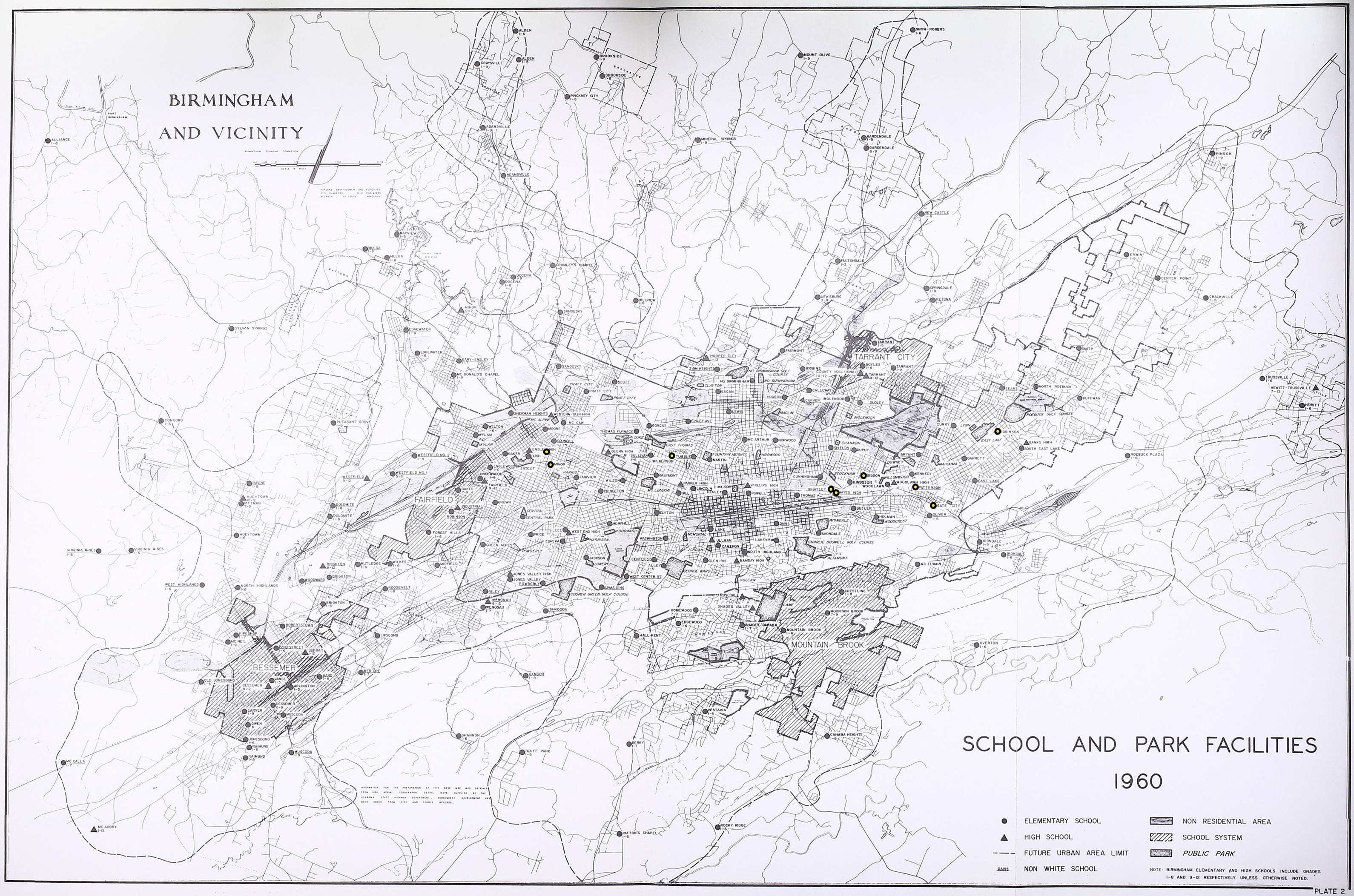
Map of schools in Birmingham in 1960, with the nine schools analyzed in this article highlighted by a thick dot. Source: Harland Bartholomew and Associates, A Report on Schools and Parks: A Part of the Comprehensive Plan, Birmingham, Alabama (Birmingham, AL: Birmingham City Commission, 1961), 12.
Demolition of African American Neighborhoods to Keep White Schools White
When Urban Renewal projects demolished African American housing, neighborhoods that were home to a mix of races became more White. This increased neighborhood segregation, and because Birmingham followed a policy of neighborhood schools, it also entrenched school segregation by allowing segregated White schools to draw from White neighborhoods. An example of an Urban Renewal plan that demolished African American homes in order to create a more White neighborhood in which the White elementary school would be zoned is Gibson school, located near the Avondale Urban Renewal area. The school was designated as a White school, but the neighborhood around it contained African American multifamily housing. In 1950, the neighborhood was home to about 3,000 people and could house up to 12,000 if fully developed with the zoning that allowed multifamily housing. 48 In 1959, the planning commission designated the neighborhood around the school White. As Connerly notes, converting the neighborhood to White residential meant that the school could draw on White students, “the planning commission was seeking to use the land use plan to convert a neighborhood from racially mixed to White so that the local White school could draw on a catchment area that was almost entirely White.” 49
The location of Gibson school was just a few blocks from the planned I-59/20 expressway, and the expressway was routed through the nearby African American neighborhood to the northeast, demolishing many of the African American homes and saving many of the White homes. 50 The effect of the Urban Renewal and the interstate highway construction was fewer African American homes near the school (Figure 5). The African American students that remained near the neighborhood were zoned for Patterson school, an African American school that was located farther away and adjacent to the interstate. In the face of increasing pressure to desegregate schools in Birmingham, the Urban Renewal project, land use plan, and the nearby new expressway provided a less integrated (more White) neighborhood from which the school could draw.

May 1933 redlining map of Birmingham, showing the redlined areas near Gibson school. The author modified the map to show the location of Gibson School and the path of I-59/20). Source: HOLC—City Survey File, 1935–1940, RG 195, Entry A1-39, Stack 450, Row 68, Compartment 6, Shelf 4, Box 156, National Archives II in College Park, Maryland.
Another Urban Renewal project that demolished African American housing near a White school so the school could be centered on a more White neighborhood was in the Ensley neighborhood (also discussed below). The Urban Renewal plan was developed in conjunction with I-59 at the southern edge. City officials viewed the designation of the Urban Renewal area as a good opportunity to locate the expressway along the edge. 51 The plan noted that several schools would be divided by the interstate highway, “on the southwest it is bounded by a [White] high school and a public park…and on the north it abuts a [African American] school…” 52 Demolition of the African American housing and construction of the interstate highway resulted in White schools being located south of the interstate and African American schools being located to the north (the Urban Renewal plan also called for constructing a new African American school, see below).
The majority of the Ensley Urban Renewal plan was located north of the interstate; however, it also demolished a small portion of African American housing that remained south of the interstate, near a White neighborhood. The Urban Renewal plan noted that with the demolition of the housing south of the interstate, the interstate could protect the White neighborhoods, “the…project…will also remove the deteriorated areas which would otherwise remain between the expressway and the sound neighborhoods to the south. This represents an example of the value of close coordination between Urban Renewal and urban highway projects.” 53 The small African American neighborhood that remained south of the interstate was demolished in order to protect the White neighborhood, and the result was also a more White neighborhood from which the school could draw, the plan noted, the “Urban Renewal area has been so delineated as to include approximately 4,200 lineal feet of right-of-way for the proposed interstate highway and to remove the deteriorated areas which would otherwise remain between this interstate highway and the sound neighborhoods to the south.” 54
Schools Seeking Change in Interstate Location or Design
When an interstate highway was proposed near a public African American school, no accommodation was typically given to mediate the negative impacts of the highway on the school, as it was for White schools. African American parents and activists had much less political power than White parents and activists. White activist’s concerns were taken more seriously, and they were able to enlist the help of powerful individuals such as Congressional representatives, to mitigate the impact of highways on White schools. Two African American schools that had significant negative impacts from expressways but received no mitigation for those impacts are Wilkerson and Patterson elementary schools.
Wilkerson elementary school was a segregated African American school located just west of downtown, adjacent to I-59/20, in the East Thomas neighborhood. 55 BPR and AHD were aware of the negative impacts that the interstate would have on the school. In one memo, BPR administrator Rex Whitton noted that a bridge or embankment near the school might be needed to protect the school from the negative impacts of the interstate highway and that a bridge would be a relatively easy request because they would not need to purchase additional right-of-way, “The topography is such that should a structure be provided, little or no additional right-of-way on the south side of I-59 would be required and the 4th Street adjustment could be made well short of 10th Avenue.” 56 BPR noted, however, that the request would need to involve upgrading a city street in front of the school, which would require funding from the City of Birmingham. BPR noted that it was unable to determine the plans for the street because it was not included in the City’s Master Street Plan. 57
Despite the relative ease and low expense of providing an elevated structure near the school, however, AHD did not request funding for it and did not request BPR’s approval for the structure. Also, the Birmingham Board of Education did not request an accommodation for the school. Therefore, the City of Birmingham did not upgrade the street in front of the school, and no elevated structure to protect the school from the negative impacts of the expressway was built.
Another example of an African American school that received no mitigation from the negative impacts of an interstate highway is Patterson elementary. 58 The interstate contains a large interchange adjacent to the school, so the highway wraps around two sides of the school. Traffic entering the interchange has significant negative impacts on the school. No accommodations were given to Patterson school to mitigate the impact of the expressway on the school, and this research uncovered no evidence that public officials, including the Birmingham Board of Education or AHD, considered or discussed moving the interchange or providing any accommodations to avoid conflicts with the school.
The experience of White schools affected by interstate highways and Urban Renewal projects in Birmingham contrasts sharply with that of African American schools. Parents and activists from the White schools, whom had more political power than African American parents, were able to work with public officials to get interstates either relocated or redesigned to include overpasses or embankments to mitigate the negative impacts on White schools. Even when there was little or no activism from parents requesting such accommodations, AHD lobbied BPR to approve plans for redesigning highways near schools to avoid negative impacts on the schools.
An example of an interstate highway that was relocated away from a White school to avoid the negative impacts from the highway is Gate City school, a White elementary school, located next to the proposed path of I-20. 59 In 1951, a large 500-unit public housing development, Marks City, was constructed to house White families, just a few blocks away from the school. 60 The original route design for I-20 proposed taking part of the school’s property, at the end of a playground area. The Birmingham Board of Education objected to the proposed route, noting that the loss of the playground area would have a negative effect on the school’s operation, with no nearby land to replace the loss. Despite the concerns of the School Board about the loss of playground space, the school had a total of 462 square feet of playground space per pupil—one of the highest in the Birmingham School District. The Birmingham Board of Education also objected to the route because taking part of the athletic grounds would render the remaining grounds useless because the expressway would create a barrier to the remaining grounds on the other side of the interstate. Also, the Board of Education argued that the school was bound by roads and a railroad and could not expand in another direction, and that the appraisal price for the taking—$7,560—was too low and did not consider the damages to the school. 61
Responding to the Board of Education’s concerns, AHD immediately reviewed the route to determine whether the taking of the right-of-way from the school could be reduced or eliminated. The state requested that their engineering consultant prepare a report to seek to minimize the effect on the school. 62 The consultant’s report proposed completely eliminating taking any of the school’s property and constructing the highway on a bridge over the area to provide access for the school to the playground on the other side of the expressway. 63 The consultant noted that the increased expenditure for the structure was justified because it would eliminate the negative effects of the expressway on the school and eliminate any taking of land from the school. 64 AHD responded favorably to this proposal, noting that “the City School Board of Education strongly objects to any right of way taking from the school property. They point out the effect any loss of area will have on their school operation, and the lack of available land to replace the loss. We are familiar with the circumstances and agree with them.” 65 In turn, BPR officials agreed that the expenditure of extra funds was worth the cost, noting “in our view, the higher cost of the structure instead of an embankment is amply justified in the public interest.” 66 Although the bridge would cost an additional estimated $253,478, BPR felt that the original right-of-way costs for the at-grade road did not adequately reflect the cost to the school, thus justifying the cost of the bridge. 67
After BPR accepted the proposal to construct a bridge to avoid impacting the school, the Birmingham Planning Commission proposed a joint use agreement to allow the school to use the area under the bridge, to provide an extra playground for the school. The proposal for a joint use agreement for the right-of-way was in contrast with other areas of the city where such agreements were rejected by AHD because they city considered them unworkable and difficult to execute. 68 The City proposed playground equipment for the space, and AHD recommended additional equipment, including swimming, tennis, and a track. 69 AHD agreed to pay for half of the cost of the playground project, and the City of Birmingham was to pay for the other half. 70
Another White Birmingham school affected by I-59 was Robinson elementary school in the East Lake neighborhood. 71 Citizens in the community formed a committee to seek to minimize the impact of the expressway on the school. They also used their political connections to enlist the help of Congressperson George Huddleston who wrote to BPR in Washington to get information about the route and its effect on the school.
In response to their concerns, AHD developed a second alternative for I-59 near the school—called the south alternate—just one block away, which would bypass the school by ninety-five feet (Figure 6). 72 The alternative that they originally choose, which they called the north alternate, would have taken the school. After determining that the north alternative provided inadequate “operational efficiency,” 73 AHD recommended the south alternate.

Map of the north and south alternative of I-59 near Robinson school (Note: this is the highest quality archival map available). The interstate was relocated along the south route to minimize the negative impact on the White school. Source: FWA Correspondence Relating to Federal Aid Primary and Secondary System Projects, 1961–1978, RG 406, Entry A 1-3, Stack 530, Row 33, Compartment 19, Shelf 5, Box 2, National Archives II in College Park, Maryland.
The decision to relocate the interstate to the south by just one block was not without controversy, particularly for the homeowners near the new route. It was particularly controversial because the homes along the original route had less value than the new route, as one property owner noted, “The route now proposed is not the most inexpensive or best, as ample undeveloped space and areas with low cost homes are available to route the roadway in the same direction within two to three blocks of the objectionable proposal.” 74
AHD held a second public hearing because the first public hearing did not consider the alternative (south) route. At the hearing, a group of citizens presented AHD with a petition opposing both routes and recommending a route farther to the north, bypassing the neighborhood, that would avoid both the school and their homes, as the citizen petition wrote, “The proposed North or South alternative will create a dangerous barrier to the schools and churches located in the residential area through which they are proposed.” 75
The route proposed by the committee that avoided their neighborhood and the school was straighter, shorter, more direct, avoided African American neighborhoods to the west, and would have taken a White section of the Woodlawn community, and a portion of the Roebuck Springs Golf Course, removing several holes from the course. The route was rejected, according to Connerly, “Apparently because the initial proposed route went right through the middle of predominantly White and commercial districts, the Alabama Highway Department selected a less direct and probably more expensive route that required lower speeds.” 76
The petition also pointed out that the alternative design would not affect any schools. 77 It also noted that at the first public hearing, AHD told attendees that economic and cost factors were minor considerations in route design, so the petition pointed out that although their alternative route design was likely more expensive, AHD should consider other factors in siting the intestate. 78
Even though the proposal to bypass the neighborhood was rejected, AHD still sought to minimize the effect of the interstate on the White school. To that end, AHD proposed raising the interstate in elevation on an embankment. BPR noted that this would minimize the negative effect of the highway on the school, “we do not consider that the 22-foot fill with a 12-foot retaining wall will cause a deterioration either of community appearance or of the functioning of the streets adjacent to the freeway.” 79 The interstate was eventually constructed on a large embankment as it passes by the school. It was also constructed along the south alternate, to avoid taking the school or going directly adjacent to it. Therefore, although the proposal for the expressway to go north of the neighborhood, passing through the White Woodlawn neighborhood and avoiding the African American neighborhood was rejected, AHD did make some concessions to minimize the negative impact of the expressway on the White school.
New African American School Construction to Keep Nearby Schools White
Urban Renewal funds were used to construct new African American schools to assure that nearby White schools could remain White. When the new African American schools were built, those schools absorbed the African American children near those neighborhoods, leaving nearby White schools to draw on White children. Examples of this type of situation are Tuxedo elementary, Whatley elementary, and Hayes middle and high school. All three schools were constructed using Urban Renewal funds in African American neighborhoods, and all three had nearby White schools that were able to draw from more exclusively White school zoning areas after the construction of the nearby African American schools.
Tuxedo elementary school, adjacent to I-59/20, was built after the interstate was constructed, as part of the Urban Renewal plan for the Ensley neighborhood. 80 The majority of the Urban Renewal project was north of the expressway; however, a small portion of the African American neighborhood remained south of the interstate, which was cleared as part of the project (see Figure 7 and the discussion above). Thus, I-59/20 became the racial boundary between the White neighborhood and Minor elementary school (a White school) to the south, and African American neighborhood and the new Tuxedo school (an African American school built using Urban Renewal funds) to the north. 81

Map showing the north and south routes through Ensley. The south route was eventually chosen, creating a buffer between the African American neighborhood to the north and the White neighborhood to the south. The map also shows the small part of the Urban Renewal area that was located on the south side of the expressway, which was demolished. Source: Alabama Highway Department Interstate Bureau, Alternate Routes at Ensley Park in Birmingham, June 9, 1961, James Morgan Papers, Highways—East-West Thru Ensley, Proposed, 13.39, Birmingham Public Library.
Prior to demolition the area contained 975 dwelling units, home to mostly African American people, the plan noted, “the area is a densely built up and populated residential slum occupied by Negroes.” 82 The Urban Renewal plan created 488 units of new African American multifamily housing and the new school north of the interstate, with duplexes located south of the interstate. With the construction of the new Tuxedo school, the Birmingham School Board could use the new interstate highway as a line for dividing school zoning districts and maintain segregation of schools because the neighborhoods were segregated. Further, since the Urban Renewal plan removed African American housing on the south side of the expressway, the neighborhood zoned for Minor school (a White school) became home to more White people, and with the construction of new African American housing in the Urban Renewal area north of the interstate, the neighborhood zoned for Tuxedo school was African American. Therefore, this school fits into two categories in this analysis—it was in an Urban Renewal area that demolished African American homes in order to make a neighborhood zoned for a White school more White (see above), and it also involved the construction of a new school that allowed the city to avoid zoning kids from the African American neighborhood to the nearby White school.
Similarly, Whatley elementary school and adjacent Hayes middle and high school were constructed using Urban Renewal funds in 1960 and provided an African American alternative to nearby White schools in order to keep neighborhoods and schools segregated. 83 The schools were located in the Avondale Urban Renewal area, a low-income, predominately African American neighborhood that was isolated from White neighborhoods by large roads, a railroad, and industrial land.
The Urban Renewal plan for Avondale called for demolishing over 2,000 African American homes and replacing them with industrial uses and African American residential housing. Part of the impetus for the Urban Renewal designation was to improve the appearance of the area that was the main route to the airport. 84 The plan also called for the new African American elementary and vocational high and middle school. 85 Construction of the schools was located down the road from Gibson school, which was designated as a White school.
Construction of the new African American elementary school allowed local school officials to assure that White children would be zoned for Gibson school. African American children in the area around Gibson previously had been zoned to attend Thomas school, an African American school that was over two miles away from Gibson school. Therefore, with the construction of Watley school just a mile away, school officials zoned the African American children to Watley and White children to Gibson. By building a new African American school in the neighborhood, therefore, White officials could argue that both White and African American children had schools in their neighborhoods, and African American children no longer had to travel long distances to a segregated African American school when there was a White school closer to their neighborhood.
School officials were relying on the concept of neighborhood segregation to keep neighborhood schools segregated, 86 as the Birmingham Planning Commission wrote in the 1961 Comprehensive Plan Preliminary Report, “elementary schools serve students with a basic radius of one-half mile.” 87 Not surprisingly, nearby White residents—whose children were zoned for Gibson school—supported the construction of the new African American schools. The residents formed a committee to work with City officials and expressed their support for the new schools, “We feel that this Avondale area would be most appropriate for an elementary school and high school, and would furnish educational needs for many years to come.” 88
Another example of Urban Renewal funding that was used to build a new African American school in order to avoid African American students having to travel outside their neighborhoods (past White schools) is Hayes school. Prior to the construction of Hayes school, the only public high school for African American students in the city was Industrial High School, located about five miles to the west. Therefore, African American high school students from Avondale had to travel a long distance over many major roads to get to school. The new high school would relieve overcrowding in the only African American high school in Birmingham, and avoid students having to travel a long distance to school. Also, the new school allowed city officials to argue that African American schools were comparable to White schools and located in African American neighborhoods, and thus, school segregation was due to individual preferences to live in segregated neighborhoods. 89
Assessment and Conclusions
African American students were disadvantaged when potential interstate highway routes would affect their schools. The African American schools analyzed in this article did not receive any accommodations to lessen the impact of a highway on the schools. This is especially important given the fact that African American schools were also closer to major roads and in more dangerous locations in the first place. One school (Patterson) was located directly adjacent to a major interchange—the last exit before I-20 meets I-59. Patterson is surrounded on two sides by the interchange and the expressway. This is contrary to the Birmingham Traffic Engineering Department’s recommendation that structures such as underpasses be provided where schools conflict with busy roads, “pedestrian underpasses or overpasses should be constructed where feasible. These structures are the permanent solutions to the school crossing problem and should be constructed where warranted and feasible.” 90 African American schools had more to lose from interstate highway construction and Urban Renewal. African American schools lost land to the interstate highways, even though those schools were on smaller lots to begin with.
In contrast, the interstate highways were redesigned or rerouted away from White schools to avoid taking any land. Therefore, White schools had land available to them for expansion, while African American schools did not. For example, Gibson school, a White school, was small and poorly designed when the interstate highway was constructed near it; however, the highway left plenty of room for expansion, and the school has been expanded and completely rebuilt over the years. This would not have been possible if the interstate had been routed closer to it, as it was for African American schools.
The loss of land and proximity of expressways to African American schools also affected playground and sports space. White schools began with more playground space than African American schools and didn’t lose it to interstate highways, while African American schools had less playground space to begin with and lost some of it to interstate highways. 91 This left African American schools even more disadvantaged than White schools.
White parents and activists held more political power and were able to convince public officials to give their schools accommodations that would lessen the impact of the interstate highways. It was common for powerful elected officials to get involved in issues involving conflicts between White schools and interstate highways. Bridges and embankments near White schools were a common solution to avoid the negative impacts of interstate highway near White schools, while none of the public African American schools were able to receive the same type of structure. Activists for one White school (Robinson school) were able to get a highway rerouted away from the school. However, both the original routing and the rerouting were through White neighborhoods, and there was no nearby African American neighborhood through which the interstate could be routed.
In the hierarchy of addressing the impacts from interstate highways in Birmingham, middle-class White neighborhoods are clearly at the top, followed by White institutions, such as schools, and working-class White neighborhoods, with African American schools and neighborhoods at the bottom. Many of the school cases in Birmingham indicate that when faced with decisions that pitted White schools against White neighborhoods, White schools were able to get minor design changes to lessen the impact of expressways, but it was not at the expense of White middle-class neighborhoods. Overall, and not surprisingly, activists for the White schools impacted the interstate highways were able to affect more substantial changes to the design of the interstate highways, and their concerns received a more response than concerns about African American schools.
At the same time, however, this research uncovered few activists working in the interests of African American schools as they related to interstate highways. When mitigation measures for African American schools were proposed, they often came from BPR—not community activists. Similarly, other researchers and BPR documents have noted that an absence of a large-scale freeway revolt in Birmingham. Although this research did not identify a reason for this, it is possible that the tumultuous civil rights activities in Birmingham that were occurring at the same time occupied activists to the extent that expressway issues took less priority. Another potential explanation is because activists were actively working to desegregate schools in Birmingham, and desegregation almost always meant that African American children would attend formerly White schools—not the opposite. More research in this area could help shed light on these issues.
Interstate highway construction and Urban Renewal were designed to affect neighborhood segregation and designed to create single-race school zoning boundaries, in order to avoid integration orders. The Birmingham Board of Education used Urban Renewal funds to resist school desegregation orders by entrenching neighborhood segregation, committing to a policy of neighborhood schools, and drawing school zone and neighborhood lines to coincide with racial boundaries. 92 Urban Renewal funds were used to build new African American schools and demolish African American homes in racially mixed neighborhoods, allowing nearby White schools and neighborhoods to maintain segregation.
Public officials at all levels of government conspired to listen and respond to the concerns of White residents about the location of interstate highways and ignore the concerns of African American residents. They also conspired to assure that planning decisions, including interstate highways and Urban Renewal, reinforced patterns of residential segregation and helped maintain school segregation. This pattern is evident throughout several state administrations and AHD and BPR leadership. The pattern of conspiracy at all levels of government is also evident in Urban Renewal, as Connerly notes, “The Avondale case demonstrates how the planning commission, in cooperation with the housing authority and the school board, could use public improvements (for example, new schools) to fix the racial characteristics of the neighborhood, even in a situation where a handful of Whites occupied the neighborhood.” 93 In any equation in Birmingham, segregation was at the top of decision-making. 94
Highway route choices and Urban Renewal boundaries and plans are path dependent, and there was little incentive for new administrations to deviate from the initial route decisions. For routes that involved a conflict, the previous administration had already presumably sustained some of the political damage and fallout from those choices. If the new administration was to change the routes and boundaries, it may open up new conflicts about those choices. Despite multiple changing state administrations, therefore, new department directors and governors often publicly championed the route decisions of previous administrations, even when they changed policy directions on many other issues. 95
It is important to view the connection between planning and segregation from a wholistic lens. Birmingham and Alabama public officials used every outlet available to segregate communities and maintain school segregation when faced with court-ordered integration orders. Interstate highway construction and Urban Renewal affected communities in many ways and, as this research demonstrates, had important differences in how they affected neighborhoods and schools.
Footnotes
Acknowledgments
The author thanks the anonymous reviewers for their helpful comments on an earlier draft of this article. She also thanks Stuart Meck, FAICP, for his friendship, inspiration, and insight on planning history.
Declaration of Conflicting Interests
The author(s) declared no potential conflicts of interest with respect to the research, authorship, and/or publication of this article.
Funding
The author(s) received no financial support for the research, authorship, and/or publication of this article.
