



Abstract
North Bengal is an area of heavy rainfall through which rivers flowing down from the Himalayas have been frequently overflowing and changing their beds in the soft alluvial soil. Floods have, therefore, been a recurring phenomenon, caused by snow-melting and heavy rainfall. The present article is an intensive study of the floods that ravaged north Bengal in a period of over 50 years (1871–1922) during which the ground surface changed with the building of embanked railway lines, other embankments and dams thereby blocking the natural drainage lines of the past. The article also chronicles how the local populations suffered from the constant recurrence and increasing virulence of floods. It thus aims to bring together the information we have on the environmental and the human history of the region for a period of about 50 years of colonial rule.
Introduction
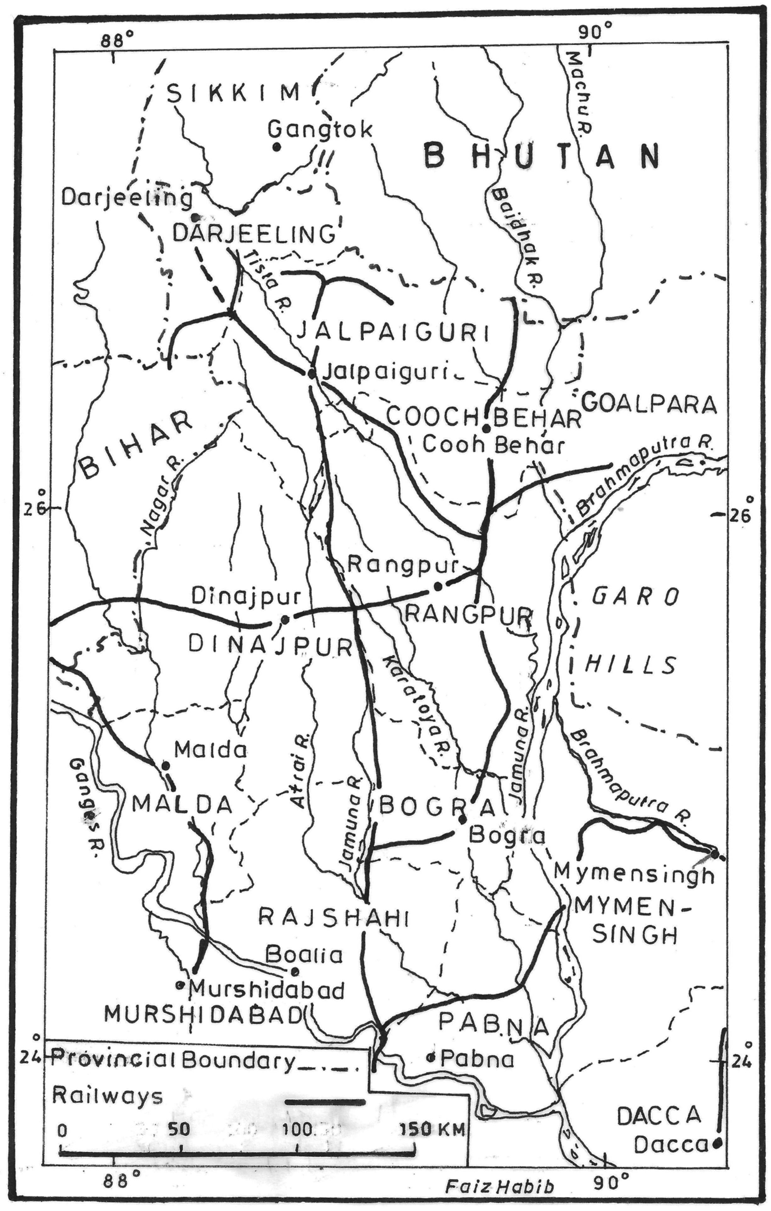
The face of the plains of north Bengal (see Figure 1) has been largely shaped by silts deposited by its numerous rivers, large and small. The intensity, duration and geographical distribution of rainfall throughout the region have constantly raised the water-level in the rivers which produced floods that carrying silt and vegetation away have continuously altered the shape of the ground. Undivided northern Bengal, comprising the districts of the Rajshahi Division (Jalpaiguri, Darjeeling, Rangpur, Dinajpur, Malda, Rajshahi, Pabna and Bogra), has displayed certain distinctiveness in respect of climate, river influence and rainfall which have brought natural disasters upon it again and again. The Himalayan rivers along with their large and small tributaries intersect and irrigate the whole region. Tista, the largest river of northern Bengal, has many times brought down large quantities of water due to the melting of glacier or heavy rainfall in the hills, inundating a large tract of land spread across northern Bengal. Other rivers of northern Bengal like Karatoya, Lish, Ghish, Torsa, Jaldhaka, Kaljani, Mahananda, Atreyi, etc., also flooded the region frequently. Ganges, rolling down to the southern part of northern Bengal mainly through the district of Murshidabad, also caused severe floods.
The Himalayan sources of the major rivers made their behaviour unpredictable since they would any time bring down large amounts of water and mud in floods caused by melting of snows or excessive rainfall in the hills. The loss of human life, cattle and property naturally caused much misery. Destruction of crops and increase of food prices caused famine-like conditions again and again. Floods that were principally attributed to the increase of rainfall were aggravated by human interference with the natural flow of water through the construction of embankments, roads and railways. The intensity and duration of suffering were aggravated by the government’s indifference. So, it is pertinent not only to trace the causes of the floods, but also to consider the plight of the victims whose bread and livelihood were affected by the flood.
North Bengal, 1922
Rivers and Rainfall: Floods and Vulnerability in Colonial Northern Bengal
The reprint of the book of Radhakamal Mukherjee in 2009 with an introduction written by Arun Bandopadhyay has renewed the discourse on the changing pattern of river courses and floods from the seventeenth or eighteenth century onwards and their impact on Bengal’s agriculture, population and public health. While Mukherjee has traced in his book the continuous riverine changes through drying up of older river channels during the eighteenth and nineteenth centuries along with the creation of new rivers, Bandopadhyay has well summarised the work on this subject done by Mukherjee, William Wilcocks and C. Adams-Williams during the early part of the nineteenth century. 1 The diverse arguments among the colonial engineers, irrigation officers and hydrologists relate to the relevance and vitality of the issue of riverine changes and their impact. Differing opinions were held, for example, by Wilcocks and Adams-Williams regarding the issues of flood records, measures of channel volumes and the impact of railways and embankments on the occurrence of floods.
The recorded history of devastating floods that occurred in colonial northern Bengal can be traced back to 1787 when the Tista changed its course leading to the Ganga and took a new path making it a tributary of the Brahmaputra. This flood considerably altered the agricultural geography of north Bengal where new problems of drainage and irrigation emerged. 2 The flood of 1787 also produced a severe famine in the abandoned area. In the Malda district floods of a destructive character were of frequent occurrence and between 1850 and 1870 there were three severe inundations which caused great suffering in all parts of the district, especially in the low lands along the rivers. These floods were not so much produced by the heavy rainfall on the spot but took place due to the abnormal rise in the rivers as a result of rainfall at the upper parts of the mountain-fed rivers. 3 In 1856, a very severe flood occurred in the Ganges. The Murshidabad embankments burst at Lalitakori, the whole country below was inundated, and the crops and large numbers of cattle were destroyed. In the district of Rajshahi floods of severe magnitude, which caused serious damage to the harvest, took place in 1838 and 1865. The flood of 1865 was caused by the excessive rainfall. 4 Though Rampore Boalia, the sadar town of Rajshahi district, was protected by a seven-mile-long embankment, it yet suffered from periodical overflows of waters. 5 One such an incident took place in 1864 when under the flood from the Ganges greater part of the town ‘including the Government offices, was swept away’. 6
It was not before the beginning of the second decade of the twentieth century that the Government perceived the necessity to compile the documentary evidence available regarding the floods in north Bengal. The Government then appointed the North Bengal Flood Committee in February 1923 under the chairmanship of G.T. Huntingford, Officiating Chief Secretary, Public Works Department, Government of Bengal, in order ‘to prepare a series of maps showing the actual position and quantity of the rainfall immediately preceding some of the more important floods … which had actually occurred in North Bengal during the period 1870–1922’. 7 After analysing the Administration Report of Bengal from 1870 to 1922 and the District Gazetteers of all the districts of Rajshahi Division, the committee presented a list of important floods. It classified all floods under four heads—Catastrophic which involved considerable direct loss of human life and great destruction of cattle and crops; Severe that caused small loss of human life and significant destruction of crops and cattle; Moderate floods which caused sizeable damage to crops and cattle but no loss of human life; and Slight which involved minor damage to crops but no direct loss of cattle or human life. 8 The present article deals with the occurrences of severe floods and their impact on society and economy of northern Bengal.
The Floods of 1871
The 1871 flood was caused by unprecedented rainfall in the monsoon period. The monsoon of 1871 had carried a large amount of water with it. Though the year 1871 had witnessed a great quantity of rainfall, it widely varied from district to district. During the second half of August rainfall increased considerably and in September there was excessive rainfall in different parts of north Bengal (Table 1).
Rainfall in the Second Half of August and 12–16 September in North Bengal, 1871

There was a huge increase in rainfall from August to September in the district of Rajshahi and Malda. On the other hand, rainfall for the whole month of August was low, and in fact, deficient in some places. There was little excess of rainfall in Pabna, Dinajpur and Rangpur in August. However, in the first week of September considerably greater rainfall than the average took place in the eastern part of northern Bengal where the volume of excess had varied from 50 per cent to 150 per cent. 9 From 12 to 16 September, rainfall was in excess of the south-eastern part of north Bengal. Though the month of September witnessed moderate excess of rainfall in some places, rainfall at Jalpaiguri ‘was in defect by 46 per cent and at Buxa by 19 per cent’. 10 In Malda (1871), the river Mahananda overflowed its banks and flooded the adjacent villages and caused serious harm to cattle, bhadoi crops (reaped in August or September) and mulberry; and the town of English Bazar and the lower portion of the police stations of Harishchandrapur and Kharba were flooded. 11 Floods in Malda had been chiefly attributed to the abnormal rise of water level in the rivers due to rainfall in the hills instead of local rainfall. Most of the rivers and streams which were running through Malda originate in the Himalayas and were vulnerable to sudden freshets produced by the melting of snow and excessive rainfall in the hills. In the diara tracts of the district the flood caused changes in the mainstream of the Ganges which resulted in cutting away of cultivable and dwelling areas that turned ‘the inhabitants of whole villages … in a night to the position of landless labourers’. 12 But this, on the other hand, created opportunities for the formation of new char lands by silt deposits which made land fertile for cultivation. The district of Rajshahi was heavily inundated by the flood which was said to believe the ‘highest floods on record in the district’. 13 When water had subsided cholera broke out in an epidemic form in the district. 14 Deaths were reported from the district, where a terrible mortality of cattle along with the destruction of crops also took place. 15 The Hindoo Patriot reported: ‘The oldest man living does not remember to have seen such a deluge, several of the fairest villages have been swept over by the flood, looking like one vast sheet of water studded here and there with huts and trees.’ 16
Flood of 1885
The flood of 1885 lasted for about one month spreading in many parts of north Bengal. In severity and duration, the flood was unequal to those of 1823 and 1871; the former of which was said to have persisted for nearly two months, and the latter for six to seven weeks. The damage commenced by breaches in the Murshidabad embankment on 23 August near Lalitakori where the water first penetrated under the embankment and eventually the embankment was partly destroyed, a breach 200-feet wide having formed. 17 The flood inundated a large tract of the district amounting to 1,250 square miles or more than one-half of the total district area. 18 Meanwhile the Gangetic flood, pouring down the Mathabhanga, breached the embankment near the Ramnaghur station of the Eastern Bengal Railway on 28 August. 19
The flood of 1885 was attributed to the floods in the Ganges, aggravated by an unusually heavy rainfall over the area affected. 20 For the temporary relief from the disaster, relief circles were built in the affected areas, and a Central Committee had been formed in Calcutta to receive donations and ‘organized relief for those forms of distress with which Government agency could not adequately cope’. 21 (In 1890 there was a similar inundation due to the bursting of the Lalitakuri embankment.) 22 The flood of 1885 in Malda was also the result of an abnormal increase of the water level in the Ganges. Throughout August Ganges witnessed very heavy rainfall in its upper course which contributed to raising the water above flood level near Malda. 23
It was stated that the flood ‘was attended with little loss of life’ in Murshidabad and the poorer classes were, for some time, put to considerable distress for food, and the cattle suffered from want of grass.
24
‘The first and most necessary’ step which was undertaken to avert any future occurrence like this, was ‘the retirement of the embankment from the treacherous soil near Laltakori (Lalitakuri), to good ground where it can be held against any flood’.
25
The other proposed measure was the provision of sufficient flood outlets on the Eastern Bengal Railway between Ramnagar and Aranghata. Moreover,
for the safety of the country liable to damage in case of high floods, orders [had been] issued for the immediate construction of a short retired line in the rear of the breach of last year, which it [was] hoped [would] be sufficient for present safety ….
26
The situation was naturally not identical in all the parts of northern Bengal. As a result of total loss of rice in the fields there were many places where the people were suffering from want of food. The Amrita Bazar Patrika wrote on 17 September:
In many parts of Bengal the people [had] eaten up their last grain. What they had has been washed away by the great inundation which [had] flooded almost all the districts of the Province. Hundreds of villages [had] been totally destroyed, and men, women and cattle swept away by the torrent. Thousands of people in those places [had] been rendered homeless and [were] likely to die of starvation, if no material help [was] sent to them at once ….
27
There was considerable loss of property and destruction of standing crops in the diara part of the district of Malda where the flood reduced the villagers ‘in a night to the position of landless labourers’. 28 But it was also believed that the layer of silt deposits brought out by the floods could ensure a good crop in the forthcoming years.
The Floods of 1892
The 1892 flood covered a greater part of north Bengal. In the first week of July 1892, there was unprecedented rainfall in Raiganj, Balurghat, Kurigram, Siliguri, Mathabhanga and Cooch Behar. In River Dharla, the water rose to an abnormal level due to the excessive rainfall. The district of Dinajpur was considerably affected by the flood which was caused by the heavy inundation from the Atrai River and below its combination with the Gabura and Ghagra streams. The flood ‘swept down on the town of Dinajpur from the north-east and washed large numbers of the inhabitants of the northern and eastern quarters out of their houses’. 29 Floods in Dinajpur were an almost annual occurrence. But what took place in 1892 was exceptionally disastrous in the history of the district.
At one time it seemed likely that the whole of the central portion of the town might be destroyed, but the timely cutting of the Darjeeling road let the water off and relieved the pressure. A dangerous feature of this flood was that its first appearance in the evening, and the darkness which ensued, added greatly to its terrors. 30
The flood caused serious damage to houses. Some money was allocated to the victims for repair of their houses. Though both the river Atrai and Punarbhaba rose but it was Atrai which by its rising caused maximum devastation. The enquiry, conducted to establish the main causes of the flood, found that ‘the railway line, which bisects the district from east to west, was in large measure responsible for the damage done by holding up the flood water coming from the north’. 31 The Raiganj–Parbatipur–Kurigram railway line held up the waters of Atrai for a long time. Increased water flowing down from the hills contributed to the serious overflow from the Mahananda river above Kisengunj, from the Atrai below Siliguri and near Dinajpur and Chirirbander and from the Dharla below Magalghat and near Kurigram. 32 Mathabhanga and Cooch Behar Suddar Sub-divisions of the Cooch Behar State were severely affected by this flood. 33 There was excessive rainfall in several parts of the district of Darjeeling where severe landslides occurred and roads were damaged. 34 Serajganj was also flooded massively as a result of excess of water in Brahmaputra which too overflowed.
The Calamities in Darjeeling, 1899
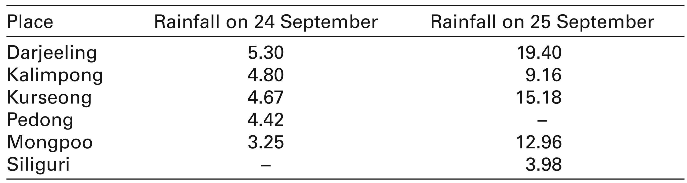
The year 1899 has been regarded as the year of the great disaster in the Darjeeling district. The rainfall during the rainy season of 1899 was exceptionally heavy there. A cyclone on 23 September, accompanied with heavy showers, continued for three days (23, 24 and 25 September). The downpour naturally varied from place to place, as shown in Table 2.
Rainfall (in inches) at Different Places of Darjeeling District on 24 and 25 September 1899
As a result of excessive rainfall, Tista waters spilled over its banks which resulted in widespread destruction especially at Tista Bazar where almost all the houses were swept away. The flood severely affected the tea gardens which lost 2,000 acres, and the value of property destroyed such as that of stocks of tea, buildings, etc. was valued at more than 10 lakh rupees. 35 Large areas of forest were washed away. River Balasan also came down with huge amount of water which caused serious destruction to the Balasan forest. The mud, water and stones carried by the constant stream were scattered over a large area and the roads were obstructed by fallen trees, electric wires and other debris or were washed away. The four consecutive natural calamities—cyclone, excessive rainfall, flood and landslips—took a heavy toll in the district of Darjeeling where deaths occurred among both Indians and Europeans. 36 At the eastern side of the Mall of Darjeeling, there was a series of continuous landslips, most of which were generated from near the top of Observatory Hill. The destruction and the loss of life in Darjeeling received wider notice than during any previous calamity that had occurred in the district. 37 The landslides caused severe damage to buildings, roads and overall communication system. 38 The Government appointed a committee to formulate strategies to deal with such situation in case of future occurrence and to minimise their consequences. The committee under Holland of the Geological Survey of India, after a thorough inspection of roads, buildings, rails and drains; reported that the causes of the landslips were the ‘defective drainage of sites, excessive load on drains, imperfect or badly constructed revetments, neglect to reduce or protect steep slopes, defective supervision of building sites, quarrying in unsafe localities, etc. …’. 39 It was only in 1900 that the Bengal Act I conferred some of the necessary powers and responsibilities on the local authorities to enable them to protect the mountainside better. 40
Floods of 1902 and 1906
The district of Jalpaiguri was severely inundated in 1902 and again in 1906. It has been argued that uninterrupted rainfall in the Darjeeling Hills and in Jalpaiguri and Cooch Behar resulted in an exceptionally large quantity of water flowing into the Tista which overflowed its banks and so caused floods. 41 Moreover, in the central part of north Bengal, that is, in the districts of Rangpur and Dinajpur, rainfall was very heavy in the month of September—Rangpur had 107 per cent and Dinajpur had 75 per cent excess of rainfall. 42 On 26, 27 and 28 September rainfall was remarkably heavy in Bogra, Pabna, Rajshahi and Malda districts, though no flood was reported from anywhere. 43
The rainfall at Jalpaiguri during the month of August (1902) was above average and again in September it was excessive (100 per cent or more) which caused a great rise in the Tista’s water-level. It started to flow with much force but its flow was checked by the railway embankment built for the Eastern Bengal State Railway. The flood, however, caused an extensive breach in the embankment and ravaged rice fields down to the Ghoramara river. There appeared a number of breaches between the main breach and Mandalghat railway station where a bridge was washed away. 44
The flood caused some deaths. The total reported number of lives lost in the flood was ‘only’ ten including ‘three herdsmen’, ‘three women and two children’ who belonged to poor families and were exposed to such danger very frequently due to their failure ‘to reach the high bank in time’. 45 Loss of cattle was estimated at a great number—350 heads of cattle and 20 buffalos were lost, the Deputy Commissioner reported. There was a large herd of about 500 buffalos on the Nathua Khal when it was submerged in the flood and only 79 among them were rescued. 46 But most surprisingly, it was reported at the same time that ‘little damage was done to the crops’. One would be surprised to think that the flood had taken toll of cattle and buffaloes, whereas crops remained standing in the field! Parts of Cooch Behar were also affected. The Cooch Behar Narrow Gauge State Railway was reported to have been badly damaged by the flood. 47
Severe and extensive floods again occurred in the districts of Cooch Behar, Jalpaiguri, Rajshahi, Pabna and Malda in August and September of 1906. In Jalpaiguri floods took a severe form: Though the flood of 1902 had been limited to the basin of the Tista, in 1906 it spread throughout the district. 48 To the west of Mal Bazar, several bridges were washed away including the bridge over the Kumlai river and a series of breaches were made in the embankment, among which the breach near the Chel river was the widest. 49
Nagrakata and the surrounding tea gardens situated to the east of it heavily relied on the Ramshai Hat railway station for their purchases of rice and coal and for transport of tea to its distant destinations. The flow of traffic on the Ramshai Hat-Sulkapara and Ramshai Hat-Gairkata roads ‘was in consequence very great, and efforts were now directed to make these roads passable for traffic to keep them open’. 50 The major damage in the Bengal–Duars Railway caused by flood led to a recognition of the need to build an alternative roadways between Ramshai Hat and the tea gardens, lying between the Jaldhaka and Torsa rivers. Construction of a road was started within the Tondu forest and a protective embankment was proposed to be built along the line of the Tista in order to protect the town of Jalpaiguri from flood. 51 Western Duars of Jalpaiguri district had also been devastated by the 1906 floods. Destruction of crops led to abnormal rise of prices of food grains. This severely affected the tea garden workers who looted a tea garden haat at Bataigol near Malbazar and a few shops near Chalsa railway station. 52
In the district of Malda during the post-flood period the price of rice increased to 6 seers per rupee, and as a result relief measures were initiated by the Government through the extension of advance of lakh of rupees under the Agriculturists’ Loans Act.
53
The high prices of rice resulted from the sudden increase of demand from East Bengal. Otherwise the crops were adequate in the barind region of the district which escaped from the flood owing to its higher terrain.
54
The Bengalee reported that—in Malda
rice and all the vegetables and other eatables [had] been selling at famine price for these two months and a half and the state of things [had] at last assumed a fearful aspect…the present famine [was] almost unprecedented in the annals of the district of Malda…the aus crop… [had] also been washed away by the persistent and high flood of the last few days.
55
Rajshahi also suffered from the scarcity of food grains. The Rajshahi Famine Relief Committee attempted to start relief operations
on a moderate scale helping able-bodied men and women with relief works and men of limited resources with cheap rice sold to them at a rate considerably below the market price and with gratuitous distribution of food to those who by long starvation have become unfit for work.
56
Starvation took away life of a woman whose two infant daughters suffering from chronic starvation had turned into ‘skeletons’. Since Government funds were not sufficient ‘kind hearted ladies and gentlemen [were] earnestly requested to come to the help of suffering humanity’. 57
The Princely State of Cooch Behar was also visited by a terrible flood in the first week of August 1906. Though the flood had spread to all parts of the State, it caused maximum damage to the twenty-eight Taluks in the Mathabhanga sub-division. Roads were damaged throughout the State and due to the ‘destruction of two large bridges and some other breaches on the line from Gitaldah to Cooch Behar, railway communication was suspended for four days from the 5th August’. 58 Cholera broke out in most parts of the tract that had been inundated. In addition to this high prices now prevailed to add to the suffering of the people.
The Floods of 1918
The districts of Rajshahi and Bogra were severely affected by flood in 1918. Heavy rainfall in the district of Rajshahi coincided with equally abnormal rains in the neighbouring districts of Dinajpur and Bogra, from where water drained into the northern parts of the district of Rajshahi.
59
About one-half of the district (about 1,200 square miles) was affected by the 1918 flood, ‘the height of which varied from 2 to 4 feet above’ danger level.
60
It was said to be ‘a flood [which] had not occurred for over a century …’.
61
The districts of Rajshahi, Dinajpur, Bogra and Pabna were inundated ‘causing much damage to crops, homesteads, and cattle over an area of about 1,300 square miles, particularly in the districts of Rajshahi and Bogra’.
62
The main line of the Eastern Bengal Railway was also affected. From 24 August the water level began to rise abnormally and reached its highest point on 30 August. ‘Two aged persons and three children were killed by the fall of mud walls and three children were drowned’—reported the Collector of Rajshahi.
63
In addition, the Collector reported that more than 7,000 houses were severely destroyed and cattle were suffering from want of fodder and shelter since they had been standing in the water for days. The aman crop was severely damaged and this ‘loss was directly due to the long immersion in the flood water’.
64
In the month of September, the situation worsened further. Amrita Bazar Patrika reported:
Heartrending details of distress occasioned by high flood continue to come from the districts of Rajshahi and Bogra. Naugaon…has suffered most and thousands of people have been rendered homeless…. Of the 4,000 villages affected by the flood the Committee has been able to extend relief operations to 100 villages only.
65
It is important to note here that the relief committee did not succeed in providing relief to most people in distress, despite the official declaration that the relief was ‘promptly rendered’ through ‘a novel method of … the distribution of seeds by way of loan’. 66 It was reported that about four lakhs of rupees were distributed in agricultural loans. 67 In spite of all these measures, many people were still starving for days while some were ‘being ill-fed with un-boiled rice which sells 5½ seers a rupee’. From the district of Bogra it was reported that, 2,000 families there were homeless and about 1,000 people were starving. 68 Apart from Rajshahi and Bogra, the district of Dinajpur was also inundated by heavy rainfall from the end of June. Numerous houses were drowned and roads were under water when the river Punarbhaba rose and flood waters penetrated into the low-lying areas of Dinajpur town. 69
The Princely State of Cooch Behar also suffered from excessive rainfall during the year 1918. From the month of June, rainfall was increasingly heavy, the month of June witnessing the maximum rainfall of the year (45.11 inches). The rainfall registered at the Sadar Station was 158.37 inches against 114.97 inches of the previous year. 70 The excessive rainfall caused serious damage to the crops. Bitri crop ‘could not be harvested owing to the heavy rainfall and the out-turn which promised to be a bumper one turned out to be 12 annas (75 per cent) only’. 71 The heavy rainfall recorded in July retarded the transplantation of Haimanti seedlings especially in low-lying lands. 72
The Flood of 1922
One of the most disastrous floods overwhelmed the Rajshahi Division in 1922. This was caused by excessive rainfall throughout north Bengal. The rains were brought about by a strong depression that formed in the Bay of Bengal on 21 September and passed through north Bengal producing exceptional rainfall on 23, 24, 25 and 26 September. The heaviest rainfall occurred in the Atrai and Punarbhaba Basins. 73 Balurghat, Gangarampur, Gazol, Naogaon and Natore witnessed abnormal rainfall, for ‘almost as much rain fell in one week as during the course of three months in a normal year’. 74
Meghnad Saha, Professor of Physics, Allahabad University, and the Publicity Officer of the North Bengal Flood Committee, wrote an article titled The Great Flood in North Bengal in the Modern Review (Vol. 32), November 1922. Saha divided the river system of north Bengal into two major groups—the Ganges (or the Padma) on the south and south-west with its tributary the Mahananda, and the Jumna or the Brahmaputra on the east with its tributary the Tista on the north-east. 75 Atrai, another major tributary of the Jumna, received waters from numerous small streams of this region, its course roughly indicating the line of the greatest slope. 76 The flood of 1922 which occurred in the Atrai basin largely owed its destructive effects to the raised railway lines which blocked water passages. 77
The rain-water descending from the Balurghat Subdivision swept across the Balurghat-Hill District Board road, and brushed against the railway line. Up Santahar, this volume of water bifurcated. The upper part broke through the upper section of the line, between Jamal-gunge and Akkelpur at several places, on the night of the 25th September…the flood water came at right angles against the Bogra-Santahar line and breached it at several places, east and west of Adamdighi…. The only way of escape was through the channel of the Atrai and some other small rivers… [which was] very insufficiently provided with culverts, and often times the culverts of the meter gauge line have no corresponding culverts on the parallel broad gauge section. 78
Moreover, it was observed that during the time of ‘reconstruction of the new broad gauge line, many openings on the original line were either closed or much shortened in width. As a result, flood waters could not pass easily under the railway line’. 79 The flood in Eastern Rajshahi, in the Panchupore Singra area, was caused by the flood waters coming from Bogra through the Raktadaha-Chalanbil line. Water only slowly subsided in the inundated area due to ‘the obstruction offered by the broad gauge line from Sara to Serajgunj’ which implied that if the Sara-Santahar line had not been laid out, the ‘flood water west of this line would have spread into this area, and would have ultimately passed through Pabna to the Jumna thus relieving the pressure west of this line’. 80
The official version, however, differed from the above. The official reports did not admit that ‘the course of western section of the floodwater which poured into Naogaon and Natore, was held up by the double line running from Sara to Santahar, causing a devastating accumulation of water for upwards of a fortnight’. 81 The Official Committee overlooked the disastrous impact of the railways and had put all the blame upon ‘freaks of nature’. The flood brought havoc upon crops in the districts of Rajshahi and Bogra where 70–75 per cent and 90 per cent crops, respectively, were destroyed. The area affected in the district of Rajshahi was three times the area affected in Bogra and was also greater in terms of loss of crops and cattle.
As colonial hydrology even at the end of the nineteenth century had yet to adopt new tools for dealing with hazardous effects of inundation, embankments were supposed to be a major protection against extended flooded area. Yet these by blocking passages for water kept large areas under flood waters for long periods. No real relief from inundations and their work of devastation was really secured.