
Abstract
This article seeks to investigate the mutual relationship between embankment and ecology and colonial policy in the changing dynamics of rivers and land in northern Bengal during the colonial period. Rainfall, floods and economy seem to be the most essential components in the history and politics of embankments in the area, a peripheral region intersected by numerous rivers originating in the Himalayas. The article sets colonial hydrology in North Bengal against the ecological vulnerabilities created by shifts in courses of rivers and by floods as well as embankments.
Introduction
Colonial policies regarding embankments and their subsequent impact on the ecology, economy and public health in India have received only limited attention from historians. Tirthankar Roy has written on how the ‘new scholarship’ in this subject ‘recognises’ the paradox of ‘how much water one can control’ rather than ‘how much land one has in possession’. 1 Colonial policy on embankments involved both land and water, and this relationship should be addressed with their mutual ‘hybridity’ instead of any ‘water-land binary’, in the words of Kuntala Lahiri-Dutt. 2 The advent of colonialism dislocated riverine ecology through the implementation of new water-blocking works which in due course changed the system of water drainage in many parts of the Indian subcontinent. Rohan D’Souza has demonstrated how colonial intervention in Eastern India transformed the ‘flood-dependent agrarian regime’ into a ‘flood-vulnerable landscape’. 3
The rivers of North Bengal flowing down from the Himalayas with massive volume of water remained a constant source of floods throughout the colonial period. 4 The Census of 1931 noted that ‘the rivers of North Bengal debouch with such force from the hills that their course is by no means a matter of certainty from year to year’. 5 The floods were accompanied by huge landslides in the hills and so contributed to the deposition of a large amount of soil and mud in the plains. In fact, environmental degradation of the Himalayas in terms of ‘overexploitation of fragile ecosystems’ led to frequent landslip and erosion which further increased the ‘rates of downstream sedimentation’ and ‘incidence of flood on the plain.’ 6 Finally, the construction of railways with tracks running well above the ground played havoc with the natural drainage lines of the region.
Embankment building in due course became one of the most contentious issues regarding water flow during the colonial period. River embankments and the embankments carrying whole lengths of railway tracks by obstructing normal water flow contributed significantly to the scale of floods in North Bengal. 7 Simultaneously, fertile ground was provided for the spread of malaria, owing to water blockage in large areas. Embankments, thus, became a site of contestation between the colonisers and colonised, based on the issues of rights and contrary interests.
Embankment, Economy and Ecology in Northern Bengal
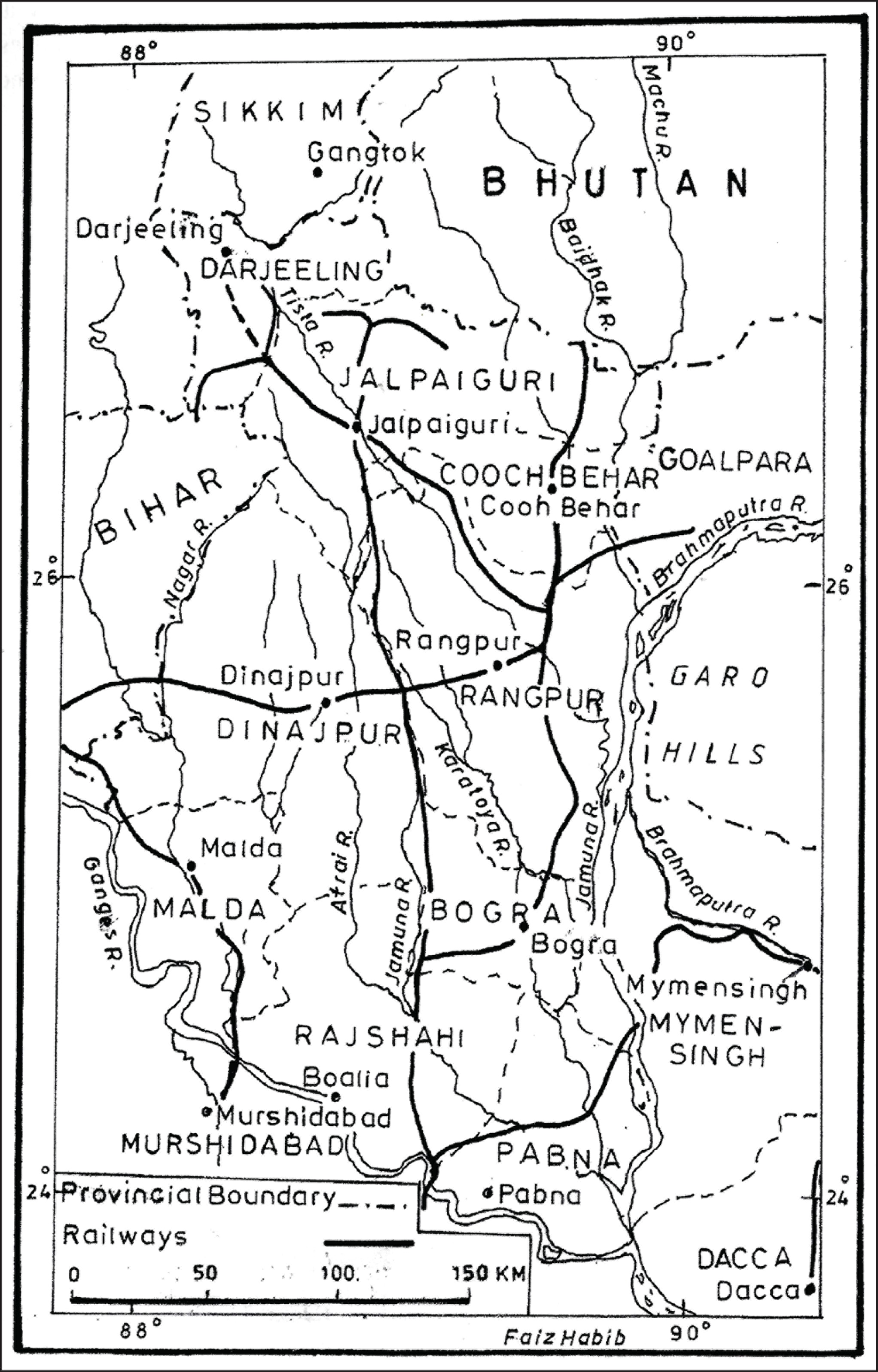
The riverine ecology of North Bengal was reshaped in a significant way during the last quarter of the eighteenth century when the Tista dramatically shifted eastwards from her old longer channel due to the devastating flood of 1787. 8 The diversion of the Tista and the natural failure of other rivers to carry increased volume of water so lost to the region, according to Radhakamal Mukerjee, greatly transformed the overall ecological condition of the region, while trade and transport were also affected by the shallowing out of several river beds. 9
The spate of railway construction involved the blockage of indigenous canals and natural drainage channels by railway and riverine embankments. Romesh Chandra Dutt has underlined the fact that ‘canals in Northern India, extensive tanks in Bengal and large reservoirs in southern India’ were all severely affected by various public works undertaken during colonial rule. 10 To begin with, embankments were constructed and maintained in two districts of North Bengal—Rajshahi and Malda. In the Rajshahi district, there were two small embankments built to protect government property when the ordinary embankments were abandoned in 1819–20. In Malda, there was only one public embankment, which seemed originally to have been constructed for the protection of mulberry cultivation and the government’s silk trade. There embankments were maintained at government expense. From the second half of the nineteenth century, controversies surfaced centring on the question of the possession, supervision, expenses and maintenance of embankments. Experience proved the Act of 1855, which had endeavoured to settle embankment issues, to be ‘insufficient’. The Bengal Embankment Act of 1873 was, thus, expected to provide ‘a satisfactory solution of the difficulties which had hitherto beset the Government’. The entire subsidiary works necessary for the maintenance of embankments, including inspection bungalows, were now regulated by the Embankment Manual of 1875. Although the ‘definition’ of ‘embankments’ had been issued as a ‘separate notice’ in the Embankment Manual, it hardly resolved the issue as to ‘whether the side lands from which the engineers used to take earth when they needed it, but which the owners used also to sow with rice or other crops’, could be included in the embankment. 11
Zamindars appeared to hold a significant place in the embankment discourse since the expenses of construction, alteration or extension of all works and the cost of maintenance and repairs related to embankment were to be paid for by the zamindars of the estates due to be benefited. It was also declared that the government could increase the amount of revenue on any estate for making provision for the embankment and its maintenance, but the increase would be later remitted. 12 In 1875, it was declared that apart from the earlier expenditure which had already been incurred, ‘any future expenditure, if incurred by public officers, must be recovered from the zamindars and proprietors benefited’. 13
In the last quarter of the nineteenth century, considerable interest began to be professed by the colonial government in its ‘obligation towards the agricultural community at large – to afford protection from inundations’. The obligation arose from the belief that ‘the time had passed when the people were ready to accept a paternal Government as an arbitrator to do justice between individuals and the public at large’.
14
Section 53 of the 1873 Act had proposed that:
Every person who, without the previous permission of the Engineer, shall erect, or cause or wilfully permit to be erected, any new embankment, or shall obstruct, or divert, … if such embankment or water course is likely to interfere with, counteract, or impede any public embankment or any public water course, … shall be liable on conviction to a fine not exceeding five hundred rupees, or, in default of payment, to imprisonment of either description for a period not exceeding six months.
15
Tirthankar Roy is of the opinion that colonial objective for constructing embankments had a ‘political’ ‘desire to control peasant societies’, and like many other forms of control, the embankments were applied as ‘tools of the empire’. 16 Elsewhere, he argues that the environmentalist discourse on embankment, so far, ignores the inherent ‘contradiction’ pointing to a pertinent question whether ‘the construction is built to save lives or reclaim land’, because the peasants, landlords and government officials naturally had different ‘valuations of these effects’. 17 The Embankment Manual enshrined a design for colonial control on embankments where indigenous requirements were deemed secondary or simply ignored. While till the end of the nineteenth century several embankments in many other parts of the Bengal Presidency were avowedly ‘maintained’ by the government ‘as a protection against floods’, 18 there were hardly any flood control embankments maintained on behalf of the government in North Bengal.
The embankments constructed in the districts of Rajshahi and Malda during the early part of the nineteenth century were meant mainly to protect government property and to serve the government’s silk trade. The Act of 1873 had re-enacted the procedure which empowered the government to enter upon lands when found necessary and allowed it to undertake desirable ‘maintenance’ of public embankments through its own engineers. In 1882, an Amendment to the 1873 Act proposed that upon any damage caused to the inhabitants by any work done under the Act, compensation was to be provided to them. 19 However, the provisions for the compensation allowed to the affected people were far too complex, and ambiguities long persisted regarding the scope and method of compensation. On the other hand, it was provided in the Manual issued under the Act that if ‘any person who shall cause, or knowingly and wilfully permit, any cattle to graze on any public embankment’, he was liable to a maximum punishment of 6 months’ imprisonment or ₹200 fine. 20 Despite the Lieutenant Governor’s sympathy for ‘every old woman who permitted a goat to graze upon an embankment’, the Legislative Council, after omitting this section, still voiced their conviction about the ‘very common offence of the villagers’ of letting their cattle ‘graze upon embankments by hundreds’. 21
Now that the railway tracts were laid, railway embankments in northern Bengal acted as serious obstructions to the natural flow of drainage and, thus, contributed to a considerable lengthening of the duration of floods. In her seminal work Tracks of Change, Ritwika Prasad has underscored the stereotyped design of railway embankments which, by the water blockage they brought about, intensified the fury of floods, thereby causing increasing destruction of crops and lives. In desperation, local people damaged or cut the embankments built upon their lands, an act characterised by the railway administration as sabotage. The Embankment Acts provided for ‘the perpetrators [to] be charged with criminal action’ for ‘malicious interference’ with railway property.
22
Thus protected, the railway embankments, as Radhakamal Mukerjee points out, greatly ‘obstructed drainage’ in Northern Bengal with ‘recurrent floods being inevitable results, especially in the south-east of this region’.
23
They also undermined proper irrigation of the fields. As Romesh Chandra Dutt has observed, ‘the British nation, more familiar with railways than with [irrigation] canals…did not adequately realise the supreme importance of irrigation works in India…’.
24
Though ‘a full examination’ of the river channels for building railway embankments north of the Ganges had been proposed in the 1870s, hardly any constructive endeavour followed.
25
In 1872, the Government of India instructed the Government of Bengal, thus:
…the best that can be chosen for a trunk line [is] through Rajshahye, Bograh, Dinagepore, and Rungpore. This line starts from the vicinity of Dhaparee on the River Ganges, and proceeds, through Nattore, Hillee, and Tengamaree, to Julpigoree. Such a railway passing through the heart of a rich country will not only be extremely valuable in itself, but will be situated so that branches may be readily constructed to Rungpore, Bograh, Dinagepore, and other centres of trade both to the east and west of the railway. A second,… aim has been to give access to the hill station of Darjeeling, the tea plantations, and to the Darjeeling Terai … [for] giving a better approach to the tea districts than a road through Titalya or Silligoree….
26
The interests of European tea planters were here held to be paramount! Tea being, a high-land crop, the European owned plantations were left unaffected by the flood-causing railway embankments, 27 but in the lower plains, there was produced a new saga of what, according to D’Souza, was sheer ‘hydraulic volatility’. 28
The construction of railway lines running above ground nearer to the rivers, no doubt, caused a marked increase of floods by holding up water for a long time or by obstructing the outflow of water from inundated areas. The enquiry regarding the 1892 flood in Dinajpur had concluded that the railway line, which ran from east to west, was responsible for much of the damage by holding up flood waters coming from the north. 29 Even embankments constructed to protect land from flood, though rare in the district of Rangpur, were sometimes themselves perceived as a source of great ‘mischief’ in that they ‘render[ed] the violence of the pent-up water ten times more destructive than it would have been [otherwise]….’. 30 Embankments constructed at Lalitakuri in 1870 on the river Bhagirathi in the subsequent years caused serious floods that swept across the Murshidabad district into Nadia. These similarly raised water level resulting in floods in the same district in 1885 and 1890. 31
The construction of north-western division of the Eastern Bengal Railway (EBR) resulted in further worsening of the water regime of northern Bengal as it interfered with the pre-existing pattern of the Chalan bil. 32 Railway expansion in the district of Rajshahi and Pabna increasingly engulfed the surrounding areas of bil, as by early 1900s, the bil was encircled by the EBR main line to the west and the Santahar-Bogra line in the north. 33 The further construction of a broad gauge line between Atrai and Santahar resulted in a great obstruction to water passage in the area: ‘the total existing waterway between Atrai and Santahar was [now] reported to be 440 feet as compared with 967 when the line was first made’. 34 The frequent flooding of the Chalan bil area affected ‘cultivators of the vast area to the north-west of the Sara-Sirajgunj line’ as the fields remained too wet for the cultivation of rabi (winter) crops. 35
Larger bridges too stood as a great source of obstruction to the water flow. The construction of a railway bridge over the Padma was proposed in 1889 by EBR for easier communication between Calcutta and Eastern Bengal and Assam. The report, prepared by Sir F.J.E. Spring, recommended the construction of a bridge on the Sara-Sirajgunj line. A major task in constructing the bridge was to prevent bank erosion and to hold the bed of the river fast under the bridge. 36 This naturally raised the water level of the river, leading to floods in the neighbourhood of the bridge. 37 The Great flood of 1922 was, thus, produced by the complex network of railway embankments which barred easy flow of river water. 38 Indeed, the 1922 flood is held by some to be the simple creation of railway expansion in North Bengal which trapped the water for long periods of time until the flood broke. 39
The natural drainage system was, thus, gravely imperilled by railway construction, which had long-term effects as well. The ground level of the rivers which were thus blocked had continuously risen by increased silt deposit, and so, river channels in the interior areas of the districts became more and more flood-prone.
40
By the late nineteenth century, health issues too had become a matter of concern, but these did not attract sufficient official attention to link them with the threat to health from floods.
41
Indeed, it was believed that ‘the Egyptian agriculturists could hardly have made a greater mistake had they dammed out the inundation of the Nile than was made by the people of Rajshahi and Jessore in constructing and keeping up the embankments which formerly existed in those districts’.
42
It was noted in 1876:
The drainage of Rajshahi can best be represented by supposing the District to be the segment of a somewhat irregular circle, of which the Ganges river forms the limb and the Chalan bil the centre. The lines of drainage would then be represented by a series of concentric lines running from the Ganges, and from the high country in Dinajpur to the north, towards the southern extremity of the Chalan bil. The Ganges bank being higher than the general level of the country, the water drains away from it. The drainage from all parts of the District converges in the Chalan bil from whence it flows away eastward.
43
All this was now a thing of the past. Colonial lust for maximum revenue generation through the expansion of agricultural settlements and tea gardens coupled with the assault on precious timber resources unleashed an unrestrained reclamation in the district. Though the practising of ‘scientific forestry’ in late nineteenth century mitigated the disastrous effect of deforestation to some extent, the effort fell far too short to cope with the problem. In fact, in 1919, the government had to admit that:
A great mistake has been made in the past in not leaving a strip of jungle along the banks of all such water courses, for this has proved itself to be the only natural means of exercising any real control over their movements. Not only have the banks in too many cases been cleared for cultivation, but no effective check has been possible over the cutting of irrigation channels, locally known as jampois, and other forms of activity in the beds of rivers. The result has been that huge areas have been ruined by the rivers changing their courses and such changes in very many cases are directly traceable to a jampoi…much land in the Duars will go out of cultivation if irrigation is entirely prohibited and much damage will be caused to tea gardens, jote lands, railways, roads and forest if river training is entirely vetoed…
44
Therefore, the solution had been ‘scientifically placed’ by proposing erection of sluice gates and ‘protective works’ for tapping mountain torrents. Moreover, river training appeared to be the most ‘necessary’ step to be taken in regard to all the rivers—large or small. 45
Having a closer look at the ideas of river training, one may note that this was undertaken largely for the protection of governmental properties and European settlements. The Bengal Duars Railway, Jalpaiguri Cantonment, tea gardens and the Alipur Duar Civil Station, for the protection of which river training was proposed, were all colonial assets; nothing was envisioned that might serve indigenous purposes. The clearing of forests and planting of tea trees which had altered the entire ecology of the district within a very short span of time reinforced the ‘question of the obligation of the men below to accept and dispose of the drainage water of the men above and the liability of the men above in converse cases’. 46 The sloping ground level of the district allowed the water to rush through the lower parts on to the plains of the district. Clearances of upper forest tracts for establishment of tea gardens had resulted in rapid flow of water, causing floods in lower areas.
Coming to the plains immediately below, there was no proper system of embankments in the state of Cooch Bihar, even by 1900. The Deputy Commissioner was of the opinion that since the rivers which were flowing through the state were ‘large’, it would be impossible to embank the rivers ‘both on account of the great expense, and their liability to change their courses’. 47 This attitude provided the ground for indifference to the increased recurrence of floods in the state. Irrigation was not common in Cooch Behar. Wells were made either by sinking baked earthen rings, about 2 feet in diameter, in the earth on the top of one another, or else, the wells were protected by a square framework of sal timber. 48 These could hardly survive floods.
Further down in the plains, there were ‘a countless number of old embankments’ in the surrounding areas of the old ruins of Gour, but these were constructed only with the object of protecting the city from the inundations of the Mahananda. 49 Till the end of the nineteenth century, ‘the rivers and marshes [had] nowhere been embanked with the object of extending cultivation’. Hunter (1876) informs us that an embankment with a height of 15–20 feet was maintained near the Civil Station of English Bazar in order to protect the town from the Mahananda. 50 The numerous marshes or bils which were found in the district were the result of river inundations. The Mahananda was considered earlier as an important and active channel of communication between lower Bengal and the sub-Himalayan districts, but the construction of railways naturally diminished its importance as a means of transport, and during the first half of the twentieth century, traffic over the river greatly declined. 51 The district of Malda had inherited ‘a large number of tanks’ which were scattered all over the Barind tract of the district. It was said that these tanks were signs of the existence of an irrigation system during ‘an earlier civilization’, and in the colonial days, they proved to be helpful for the aman crop and paddy land during the season of deficient rainfall. 52 Now, however, the river banks, or sometimes even the banks of tanks, were brought under cultivation, and this resulted in the flattening out of the banks. For the Ganges, the continuous ‘alluvion’ and ‘diluvion’ along the bank in the district of Malda became regular phenomena because the sandy bank could now offer ‘little resistance to any changes of the river course’. 53
Hunter had already admitted that ‘to embank the entire Mahananda river system would be a task entirely beyond the powers of the local zamindars’, and to the colonial administration, the project also did not appear to be ‘a profitable enterprise’. 54 A few private embankments existed in Malda for meeting regular water supply. 55 There were also two large embankments in the district—one was near the boundary between Dolachhola and Patharmandal and another near the boundary between Saidpur and Pathar Amarpur. Both of these embankments were built for irrigation purposes and belonged to the Habibpur thana (a police post as well as territory under it). 56 There were two large embankments in Jalkar Bithan and in Koar, which regulated water supply to the main boro-growing area in the Malda thana covering an area of about 2,500 acres. 57 The annual cost of maintenance of these embankments was between ₹200 and ₹300, which was realised from the tenants by the patnidar (landlord). Thus, so far, hardly any initiative had been taken by the colonial government itself which could be regarded as its own: the irrigation tanks and embankments were either early constructions or maintained by the landlords or patnidars.
Yet, the 1870 flood had foregrounded the necessity of strengthening the existing embankments, especially those protecting the city of Murshidabad. The most important protective work in the district, constructed in the late 1870s, was a line of disconnected embankments along the left bank of the Bhagirathi, which was extended from Plassey bazar to Dadmuti—a distance of about 93 miles. 58 Though the government had been paying to the zamindars the Pulbandi allowance under Section 44 of the Bengal Act II of 1882, the zamindars were criticised for their neglect in properly ‘maintaining’ the embankments. 59 This led to the decision that the Public Works Departments administer the Pulbandi allowance and maintain the embankments by arrangements made with the zamindars. 60 The Public Works Department, established in 1856, was now given the responsibility ‘for protection of lives and lands from floods by constructing embankments’. 61
There were some exceptions regarding the position of the zamindars. In North Bihar, zamindars did not appear ready to adhere to all the terms and conditions imposed upon them. In fact, big zamindars like the Darbhanga Raj were strong enough to fight for a voice in shaping ‘the direction and pace of flood control in the region’. 62 Theoretically, embankment construction was treated as mostly a government responsibility, especially as embankments on river banks were expected to provide necessary water for irrigation which would subsequently help to expand cultivable land, 63 but the confinement of the flood within the narrow river channel as a result of construction of embankments hampered the natural distribution of silt, which through its spread, used to create fertile lands. S.C. Majumdar, the Superintendent Engineer of Irrigation Branch, pointed out in 1942 that these developments had led to the deterioration of the river channels to such an extent that these could not be protected by mere earthen embankments. 64 Later, Srischandra Nandy demonstrated (1948) the relationship between the rivers and ‘economic welfare’ of Bengal and highlighted the economic costs of the decaying rivers of Bengal. 65 Rivers like the Punarbhaba, Atreyi and the Karatoya, which were already in dissipation due to the ‘diversion’ of the Tista ‘towards the Brahmaputra-Jumna’, 66 had been further affected by the restrictive railway embankments.
There was ample evidence to suppose that the riparian legislation related to embankments, drainage and irrigation was meant to serve colonial purposes rather than providing any sustainable relief to Indians. Sir William Willcocks, original designer of the Aswan Dam in Egypt, who began his career as an irrigation engineer in Bengal, accused the British in the 1920s of purposefully preventing proper flood control in the Bengal Presidency where barriers were raised only to protect roads and railways, thus, securing a continuing flow of raw materials to the industries in England.
67
Indeed, the government admitted that it was ‘only in a minor degree that irrigation for cultivation [came] within the Department’s scope’.
68
In a report to the Bengal Land Revenue Commission in 1939, the Bengal Provincial Kisan Sabha, a peasant organisation, noted:
Not only do the landlords fail to clear away the silt and to re-excavate the blocked channels and waterways and tanks; on the contrary, they often encourage the silting up of these waterways so as to form new fields which they can lease out to new tenants. A very common form of litigation… is where cultivators attempted to keep open long-established waterways but have been forcibly driven off the land by the hired gangsters of the landlords who are preparing to sow a crop in the silted up river bed.
69
Sometimes continuous silting of river channels transformed the nature of the soil and aggravated peasant distress. The Irrigation Committee which was constituted under W.S. Hopkins in 1930 reported that in the northern districts ‘where the rivers which once built up the delta of the Ganges now lie stagnant, the most important problem is to restore the flow of water in the rivers’. 70 Though during the second half of the nineteenth century efforts had been made to restore the existing irrigation canals in Bengal, Willcocks decided in favour of the discontinuation of any process of restoration of ‘ancient artificial systems of irrigation’. Problems in restoring flood water manifested themselves in a different way for Malda and Rajshahi districts where the floods were so heavy that they obstructed the monsoon harvest, and then the water receded so quickly that none remained available for cold weather irrigation. 71 Thus, flood waters were wasted in these districts along with Dinajpur leading to repeated failures of crops. As part of anti-malarial campaigns, sometimes the surplus flood water had been deliberately allowed to flow in the country, so that it could submerge as large an area as possible, thereby destroying the breeding grounds of the anopheles. 72
The impact of artificial embankments can be best understood in the words of Sir Willcocks who said he was born ‘in a tent on an irrigation canal’ in India in 1853:
If you embank the rivers and prevent their overflowing altogether and leave no openings in the banks, you doom the country to malaria and impoverishment of soil; but that is not all the harm you do. By confining high floods to their river channels, you congest the rivers to bursting point and expose the country to various serious inundations and devastations.
73