
Abstract
Infrastructure systems are critical to support sustainable and equitable urbanisation, and infrastructure is becoming more prominent within urban spatial strategies. However, the fragmented governance and delivery of spatial plans and infrastructure projects create a challenging environment to embed planning goals across the planning, delivery and operation of infrastructure systems. There is significant uncertainty around future needs and the complex ways that infrastructures influence socio-spatial relations and political-economic processes. Additionally, fragmented knowledge of infrastructure across different disciplines undermines the development of robust planning strategies. Comparative analysis of strategic spatial plans from Auckland, Melbourne and Vancouver examines how infrastructures are instrumentalised to support planning goals. Across the three cases, the analysis identified four common infrastructural modalities: rescaling socio-spatial relations through targeted intensification, intra-urban mobility upgrades and containment boundaries; re-localising socio-spatial relations to the suburban scale with ‘complete communities’; protection of ‘gateway’ precincts; and local planning provisions to support housing affordability. By examining infrastructure through a theoretical framework for suburban infrastructures, this analysis revealed how infrastructures exert agency as artefacts shaping socio-spatial relations and through the internalisation of political-economic processes. Each modality mobilised infrastructure to support goals of global competitiveness, economic growth and ‘liveability’. Findings suggest that spatial strategies should take a user-focused approach to infrastructure to meet the needs of diverse urban populations, and engage directly with the modes of infrastructure project delivery to embed planning goals across design, delivery and operations stages. Stronger institutional mandates to control land-use and provide affordable housing would improve outcomes in these city-regions.
Introduction
Urban infrastructure systems are of critical interest to support the anticipated increase in global urbanisation in coming decades, providing for sustainable and inclusive growth (OECD, 2017; UN Habitat, 2016). Moving beyond traditional views of infrastructure as merely an engineered system, and economic asset, or a ‘gap' to be filled (Mckinsey, 2016) is essential to grapple with the challenges of urbanisation. The complexity and uncertainty encountered in infrastructure planning create challenges for planning and investment decisions, given the substantial capital costs of new systems or upgrades, and the tendency toward technological lock-in and path-dependency. This uncertainty emerges from complex interactions between socio-technical systems and the political-economic systems they operate within. Infrastructures have dual natures: they can take the form of engineered physical systems or artefacts that shape socio-spatial relations, while also being imbricated in political-economic processes of urban development (Dourish and Bell, 2007). Infrastructures shape socio-spatial relations and social norms, while also manifesting governmentalities and power relations between groups (Filion and Keil, 2017): therefore opportunities for infrastructural innovations are not limited to technical fixes but engage fully with the social, political and economic functions of infrastructure systems. Robust epistemologies of infrastructure are needed to accommodate this dualistic nature and reflect that infrastructures have agency and political-economic significance (Gartner, 2016).
Urbanisation is increasingly governed at the metropolitan scale (Brenner, 2011; OECD, 2015) and metropolitan regions are subject to ongoing spatial transformation resulting from governance reforms and innovations in transport and communications technologies. The governance of urban transitions is deeply politicised (Acuto, 2012), and infrastructure investments are often central to these debates. The complex inter-relationships between spatially-bound economic, social and environmental systems and their governance create a challenge for infrastructure planning and investment decision making.
This paper analyses the instrumentalisation of infrastructures to support planning objectives, using a broad definition of infrastructure that includes both material and immaterial physical, financial or regulatory interventions that shape socio-spatial relations. Addie’s (2016) theory of suburban infrastructure is used to analyse the infrastructural modalities identified across the three cases. This theoretical framework reveals the dualistic nature of infrastructures as physical artefacts and internalised political-economic processes.
Background
‘Infrastructure’ is a ubiquitous and chaotic concept (Addie, 2016), often used as an abstraction within urban discourse and practice. The term gives apparent unity to socio-technical systems conceived in contradictory ways across planning, engineering, economic, financial and legal professions. In the context of urban planning, infrastructure and planning have been isolated between professional practices for decades (Neuman and Smith, 2010), creating epistemological and institutional challenges to aligning infrastructure design and delivery with planning (Todes, 2012).
The emergence of the ‘infrastructural turn’ in strategic spatial planning further entrenches fragmentation across disciplines (Dodson, 2009), and subsequently in global urban practice (Dodson, 2017) where project-based infrastructure investments displace spatial planning practice, over-riding planning principles with the specific discursive, technical and financial arrangements for individual infrastructure projects.
Given the uncertainty of infrastructure’s impacts on urban development, and the multiple technical disciplines responsible for planning and delivery, infrastructure decisions are prone to politicisation and infrastructure has a central role within political-economic processes. However, urban practitioners often lack the epistemological frameworks to bring political considerations to bear with technical design and planning activities. Technical professions frequently attempt to depoliticise infrastructure decisions (Swyngedouw, 2010): as a result, public debates over the desired direction of urban development inevitably play out through the detail of technical analyses (Murphy, 2014), environmental assessments (Nikolaeva, 2012) or the legitimacy of infrastructure agencies (Willmott, 2017). Inter-disciplinary knowledge and shared understandings of infrastructure are needed to avoid ongoing challenges to robust deliberation over investment decisions. Academic literature has unpacked infrastructure’s political and anthropological dimensions (Harvey and Knox, 2012; McFarlane and Rutherford, 2008; Tonkiss, 2015), but this knowledge remains isolated from practitioners' understandings of infrastructure.
Theorising infrastructure and suburban development
Rigorous theoretical perspectives on infrastructure are helpful to develop infrastructure knowledge that spans the boundaries of social, spatial, technical and political spheres. To advance knowledge that incorporates the physical and relational dimensions of infrastructures, Addie’s (2016) theory of suburban infrastructure provides a heuristic with strong explanatory capacity.
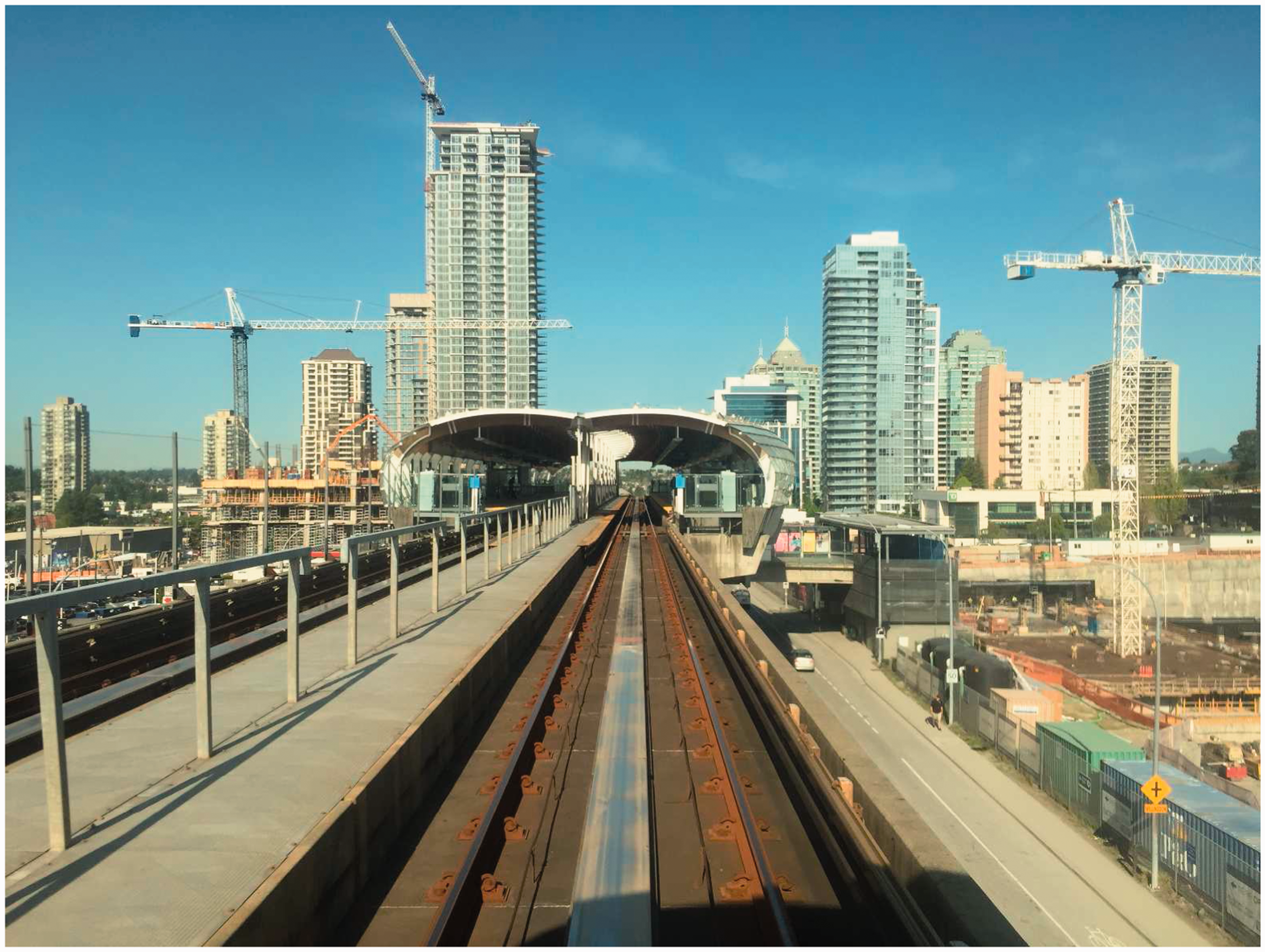
Analysing infrastructure through the lens of suburban processes recognises that peripheral areas are important sites for infrastructural innovation, arising from higher-level processes (Addie, 2016; Filion and Keil, 2017). Examining metropolitan-scale spatial plans through the lens of suburban infrastructure emphasises the interdependence between the city centre and suburbs. Infrastructures located in the centre support suburbanisation, illustrated by the Port of Auckland’s role in accommodating the bulk of car imports into New Zealand. Similarly, infrastructures in suburbs are necessary to support concentration in the centre, such as the Vancouver SkyTrain serving commuter populations from the suburbs. Analysing infrastructure with this theoretical framework accommodates the complexity of the metropolitan scale and the transformation of metropolitan areas across multiple temporal and spatial scales of change.
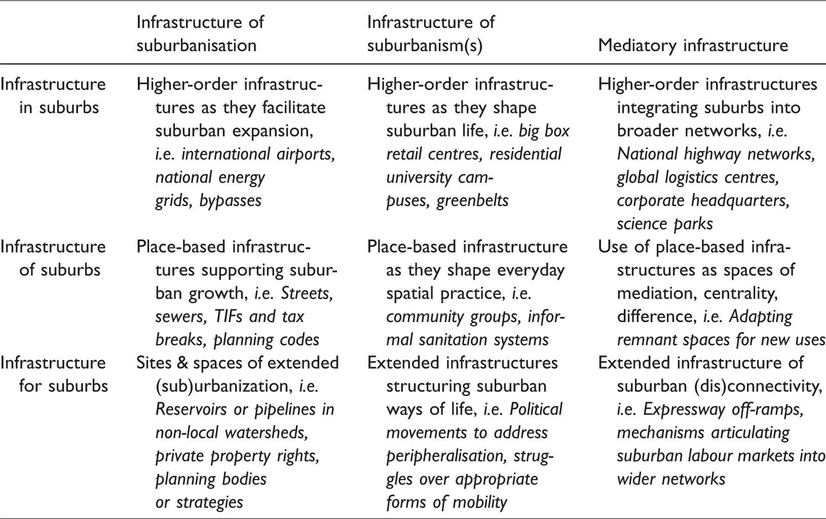
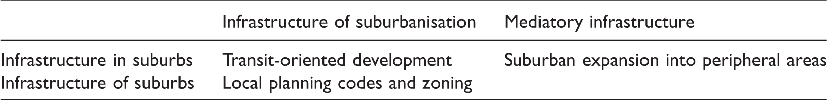
Addie (2016) theorises infrastructure according to two conceptual triads, unpacking infrastructure’s relation to suburban space and the political-economic processes that it internalises. The first conceptual triad identifies infrastructures as physical artefacts: higher-order infrastructures embedded within suburbs, infrastructures of suburbs as a result of place-based production, and infrastructure for suburbs that shape the flows of resources that support suburban life. The second triad unpacks suburban processes: infrastructures of suburbanisation that shape the exchange value of space, infrastructures of suburbanism that shape the lived experience and use value of suburban space, and mediatory infrastructures that determine the multiscalar relations of suburbs. The theory is underpinned by Lefebvrian dialectics (Lefebvre, 1991; Schmid, 2008): this does not force resolution between the two dimensions and they can co-exist whether in opposition or alliance.
The matrix generated by these two triads is shown in Table 1. The matrix offers a categorisation for infrastructures to make sense of their material and socio-spatial dimensions and move beyond the chaotic concepts that obfuscate cross-disciplinary knowledge of infrastructure.
Matrix of suburban infrastructure, adapted from Addie (2016).
Case selection and comparative analysis
Comparative analysis of three cases of strategic spatial planning identifies and examines the instrumentalisation of infrastructure to support planning objectives. Different configurations of infrastructural interventions are identified according to the matrix in Table 1 to engage with their socio-spatial and political-economic dimensions.
Three similar cases were selected, according to their metropolitan context, economic, political and geographical characteristics. Auckland, Melbourne and Vancouver are all post-colonial port cities with population size between 1.5 and 4.5 million, relative economic prosperity, similar legal and political systems, and high levels of cultural and ethnic diversity. Similarities between these cases are evident in their shared challenges: all experience severe housing affordability crises, protracted political contestation over infrastructure decisions and varying levels of segregation and inequality. Urban research is increasingly turning to comparative analysis across diverse contexts to break down epistemological divides between the Global North and South (Roy, 2009), and in light of this, comparison of three economically prosperous cities in the Global North cannot generate findings beyond this narrow context. However, given that these three cities face similar challenges – despite having little functional connection beyond migration and policy mobilities – triangulation between the three cases has explanatory potential to understand these specific challenges and highlight both opportunities and limitations for instrumentalising infrastructure within spatial planning. The analysis examines each case through the metropolitan area’s strategic spatial plan and uses contextual literature to reflect on the proposed infrastructural interventions.
This approach focuses on the state's instrumentalisation of infrastructure within spatial strategies. The use of planning documents limits the scope of infrastructural interventions considered since written documents only include interventions that fall within the responsibility of the state. The analysis does not include other important interventions such as political movements and individual spatial practices, although they are significant to influence infrastructure’s role in cities. Spatial planning documents are also performative in that they exist to justify that a strategic planning process has been followed, and support place branding strategies (Oliveira, 2015). To this end, the analysis interprets planning documents as aspirational depictions of urban futures and proposed planning strategies.
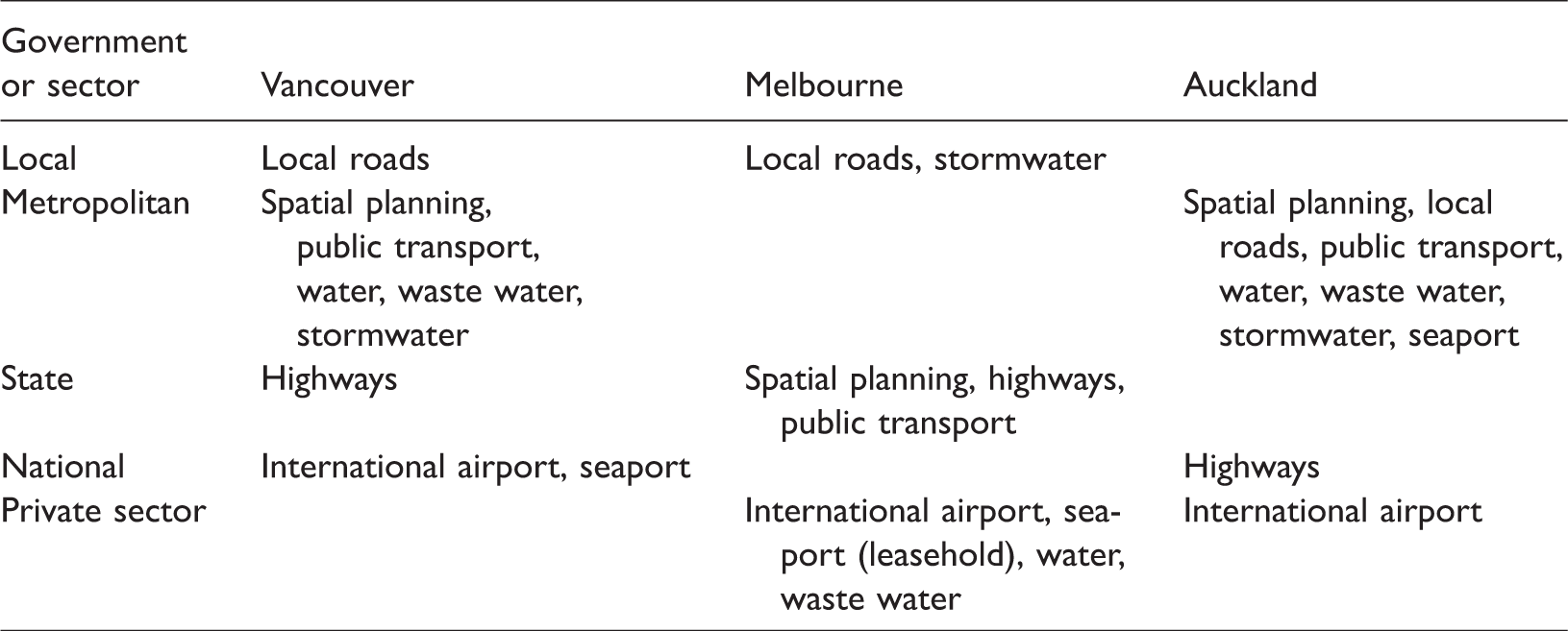
The governance of infrastructure services and spatial planning for each case is summarised in Table 2. Governing entities are those with ownership or primary responsibility for the planning and operation of infrastructure assets or services. Melbourne has no metropolitan-scale authorities; state and local authorities govern infrastructure provision, as well as the private sector for airport and port infrastructures. Governance is strongly concentrated to the metropolitan authority in Auckland and Vancouver, except for highways, ports and airport facilities.
Governance of land use planning and infrastructure services.
The documents analysed for each case are listed below, including the corresponding land area that it covers. As the comparison between the metropolitan land area and built-up area
1
illustrate, each plan covers a spatial extent that is far larger than the built-up area and so the strategies must consider the full extent of metropolitan areas to their peripheral and hinterland areas.
Plan Melbourne (Victoria State Government, 2017), produced by the Victoria State Government. Metropolitan area is 9,900 km2, built-up area 1,480 km2. Auckland Plan (Auckland Council, 2013) produced by Auckland Council. Metropolitan area is 1,090 km2, built-up area 360 km2. Metro Vancouver 2040 (Metro Vancouver, 2011) produced by Metro Vancouver Regional District. Metropolitan area is 2,700 km2, built-up area 480 km2.
The planning visions articulated across all three cities include similar goals for global competitiveness, quality of life and economic prosperity. Auckland’s vision sought to become the world’s ‘most liveable city … a place that Aucklanders are proud of, they want to stay or return to, and others want to visit, move to, or invest in’. Vancouver extends its vision to include ‘social justice and compassion … an unshakeable commitment to the wellbeing of current and future generations and the health of our planet’.
Analytical approach
In the first stage of analysis, planning documents were coded to identify all infrastructural interventions, using a broad definition that includes any intervention that shape socio-spatial relations in a metropolitan area. This definition includes material, territorially bounded artefacts or systems such as networked transport, water or energy infrastructure; immaterial, territorially bounded systems such as zoning, precincts with specific land use or taxation rules; and immaterial, territorially unbounded systems such as resource management systems and mortgage financing. Distinct modalities are identified to represent different sets of interventions. Each modality characterises the ‘manner and mechanism through which the governance of suburban spaces and environments proceeds’ (Ekers et al., 2012), encompassing physical, legal, financial and regulatory interventions. This emphasises the relationality between environmental, social and political processes to evaluate infrastructure’s multiple dimensions. The second stage categorised each group of interventions according to the heuristic in Table 1 to reveal their qualities as physical artefacts and the political-economic processes that they internalise.
Findings
The infrastructural interventions identified in the first stage of analysis showed strong similarities in the approaches taken by these three cities. While the analysis does not seek to explain policy mobilities between the three cases, superficial analysis of planning documents shows sufficient similarity to assume strong influence between these cities. Whether this is the export of ‘Vancouverism’ (McCann, 2013) to Auckland and Melbourne, use of common sources of urban expertise or best practice, or a more fluid flow of policies between all three cities, would require in-depth analysis of organisational practices over time. Local variations in infrastructural modalities reflect the distinct appropriations of infrastructure policies in different political and cultural settings.
The first stage of analysis distilled four distinct infrastructural modalities, each comprising a specific set of interventions:
Rescaling through intensification and intra-urban mobility upgrades: green belts, rapid transit investment and intensification across a hierarchy of employment centres and sub-centres. Relocalisation to suburban communities: complete communities and ‘20 minute neighbourhoods’. International gateways and logistics hubs: major sea and airport infrastructures and adjacent land for industrial and commercial uses. Housing affordability: suburban intensification and peripheral expansion to address severe housing affordability crises.
In the following sections, each modality is examined according to the heuristic in Table 1 to analyse the instrumentalisation of infrastructures to support planning goals. These modalities themselves are inter-related, and their interdependencies are discussed further in section. Limiting the scope of analysis to these dominant modalities excludes other infrastructural interventions or governing frameworks, such as Te Tiriti o Waitangi (Treaty of Waitangi) in New Zealand, which sets out fundamental principles for urban policy. Further research is needed to better understand the influence of such frameworks on urban policy and infrastructure. In limiting the focus of analysis to the four modalities listed above, this paper provides a critique and comparison of their specific instrumentalisation and not a complete overview of all relevant infrastructures for each case.
Rescaling through intensification and intra-urban mobility
The primary modality aimed to support compact urban development, using a combination of urban growth limits, hierarchies of intensified centres and sub-centres, and rapid transit investments across the metropolitan region. These infrastructures aim to rescale socio-spatial relations in two primary ways: firstly to increase the city centre residential and employment population to boost the economic ‘agglomeration premium’ and secondly to intensify suburban centres through transit-oriented redevelopment to accommodate future population growth and expand smaller economic agglomerations at the suburban level.
These two rescaling processes are supported through a combination of improved intra-urban mobility, limits to outward expansion and upzoning along transit corridors, attempting to shift to higher density land-use, shorter trip distances and modal shift towards public transport and active modes. Economic imperatives prioritise agglomeration in the city centre, to support the international competitiveness of the metropolitan area.
In Melbourne, rescaling takes the form of a hierarchical structure of metropolitan activity centres and commercial precincts, accompanied by rapid transit upgrades and an urban containment boundary. Economic imperatives underpin the expansion of Melbourne’s city centre, conceived as ‘the focus for global business and knowledge-intensive industries linked to an extensive network of clusters, centres, precincts and gateways’. The Metro Tunnel upgrade is also put forward as a ‘transformative' investment, increasing the capacity of existing rail networks and reducing congestion in and out of the central city area: ‘for the first time, key living, learning and work precincts will be linked by a high-capacity train network’.
Plan Melbourne also emphasises the need to protect green spaces, deemed: ‘immensely important to the stats economy, community and environment … It is unsustainable to keep expanding Melbournes outer-urban growth areas. If the city continues to expand, the natural environment will be impacted, commute times to employment and services will grow longer, and socioeconomic disparities across the city will increase’. However, this does not imply a ‘hard boundary’ for urban expansion and planned greenfield development accommodates 30–35% of future residential growth.
In Auckland, the city centre is also a multipurpose site: ‘a key visitor destination and New Zealands commercial, financial, educational and cultural centre. It will gain in popularity as a residential area. The City Centre needs to play a greater role in Aucklands international competitiveness and future success.’ The Auckland Plan asserts that ‘at a larger scale, the future form will comprise a network of centres (and their walkable catchments), connected by transport corridors, which will accommodate a sizeable proportion of housing and employment growth.’ These networks adopt a topological structure to re-integrate suburbs into the metropolitan area through intra-urban connectivity and intensified land use. Auckland is distinct from the other two cases as it includes satellite towns within the hierarchy of centres, although these are not all served by rapid transit.
Auckland’s City Rail Link will significantly increase the capacity of the existing rail network to ‘achieve the step change needed for the transformation of Auckland, by driving a major shift towards greater use of Aucklands public transport, and an increase in the density of residential and business development in the city centre and along the western and southern rail lines.’ Auckland nominally aims for a ‘quality compact model of growth that prevents excessive expansion into our rural hinterland’, although the estimated expansion to support future growth does extend beyond the existing periphery, with 30–40% of new growth accommodated by greenfields expansion.
Vancouver’s city centre, defined as the ‘metropolitan core’ has a unique land-use classification as the ‘principal business, employment, cultural and entertainment location for the region’. Vancouver also limits growth through an Urban Containment Boundary that is ‘intended to establish a stable, long-term, regionally defined area for urban development. The establishment of the Urban Containment Boundary reinforces the protection of agricultural, conservation and rural areas, and provides predictability for locating urban uses, major regional transportation and infrastructure investment.’
Figure 1 illustrates the Metropolitan Core, Regional City Centres and Municipal Town Centres designated for the Greater Vancouver region. Frequent Transit Development Areas mark out the planned expansion of rapid transit services, marked in blue in Figure 1, including staged expansion of busways or rail along transit corridors to improve mobility between major centres and sub-centres.
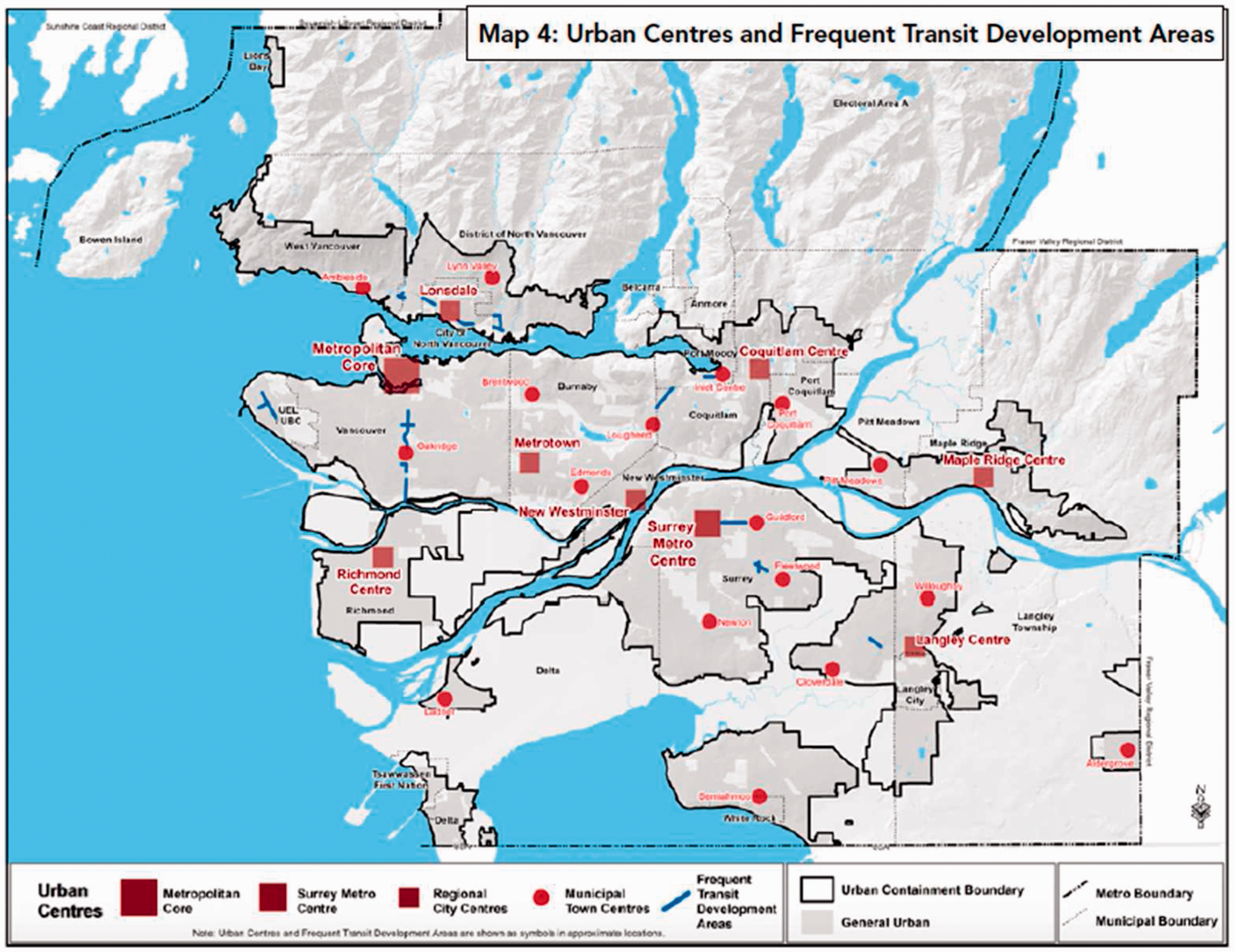
Regional land use designations, showing the hierarchy of metropolitan and suburban centres in Greater Vancouver (Metro Vancouver, 2011).
This modality of interventions spans across the matrix of suburban infrastructures, as shown in Table 3.
Infrastructural modalities.
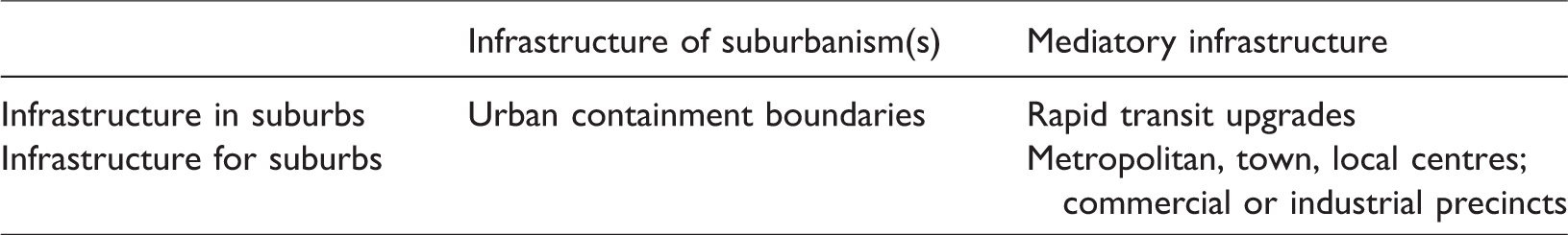
As shown in the table, this modality of interventions comprises infrastructures in and for suburbs, which are simultaneously shaping suburban life and integrating suburbs into the broader metropolitan area. Containment boundaries and zoning for city centres and sub-centres drive spatial re-centralisation. This modality reshapes suburbanisms by expanding the ‘urban’ lifestyles of travelling by public transport and active modes, and living in higher-density apartment dwellings, to suburban areas. Simultaneously, rapid transit networks and hierarchical structures of local intensification are mediatory infrastructures, seeking to re-integrate suburbs into the metropolitan labour market, ensuring their ongoing viability as places to live and work.
While strategic spatial plans set out imperatives to contain urban expansion, the growth limits imposed in each case are flexible. Between 30% and 40% of future growth is estimated to be accommodated through greenfield expansion. Peripheral expansion runs counter to the model of compact development espoused in each case, revealing the tension between urban intensification and enabling more ‘affordable’ expansion by exploiting lower-value land at the periphery.
Relocalisation to the suburbs: ‘Complete communities’ and 20-minute neighbourhoods
Accompanying the socio-spatial rescaling to the city centre and suburban sub-centres, the concept of ‘complete communities’ (Metro Vancouver, 2011) or ‘20-minute neighbourhoods’ (Victoria State Government, 2017) aims to restore a greater range of local amenities and services to the suburbs. Two strategies support this goal: providing affordable and diverse housing types, and supporting compact, mixed-use communities, with local community and social services, public spaces, active travel choices and local food production. Vancouver’s ‘complete communities’ are mandated by the regional government and implemented by municipalities through local planning. Municipalities are given discretion to select land-use planning and transport interventions, although the regional government provides technical advice and facilitates collaboration with health authorities. The Metro 2040 Dashboard (Metro Vancouver, 2018) monitors a range of measures under this goal, including housing and transport affordability for renters and homeowners, share of dwelling types, and measures implemented by municipalities. In March 2018, this dashboard showed that only two of 16 indicators are ‘on track’, suggesting that a more effective strategy may be required.
Melbourne’s ‘20 minute neighbourhoods’ propose a similar version of the complete community, with ‘accessible, safe and attractive local areas where people can access most of their everyday needs within a 20-minute walk, cycle or local public transport trip’. Figure 2 shows the definition of 20-minute neighbourhoods set out in Plan Melbourne. The strategies for delivering this transformation include upgraded walking and cycling infrastructure, unspecified ‘local transport services’ and co-location of schools and regional facilities with public transport, walking and cycling routes. Plan Melbourne acknowledges the challenge of reducing travel demand, due to dual-earner households and the diverse, specialised labour market that requires many workers to travel outside their 20-minute neighbourhood. Re-scaling employment to suburban centres is also in tension with the goal of increasing agglomeration in the city’s labour market as it may draw employment growth away from the city centre.
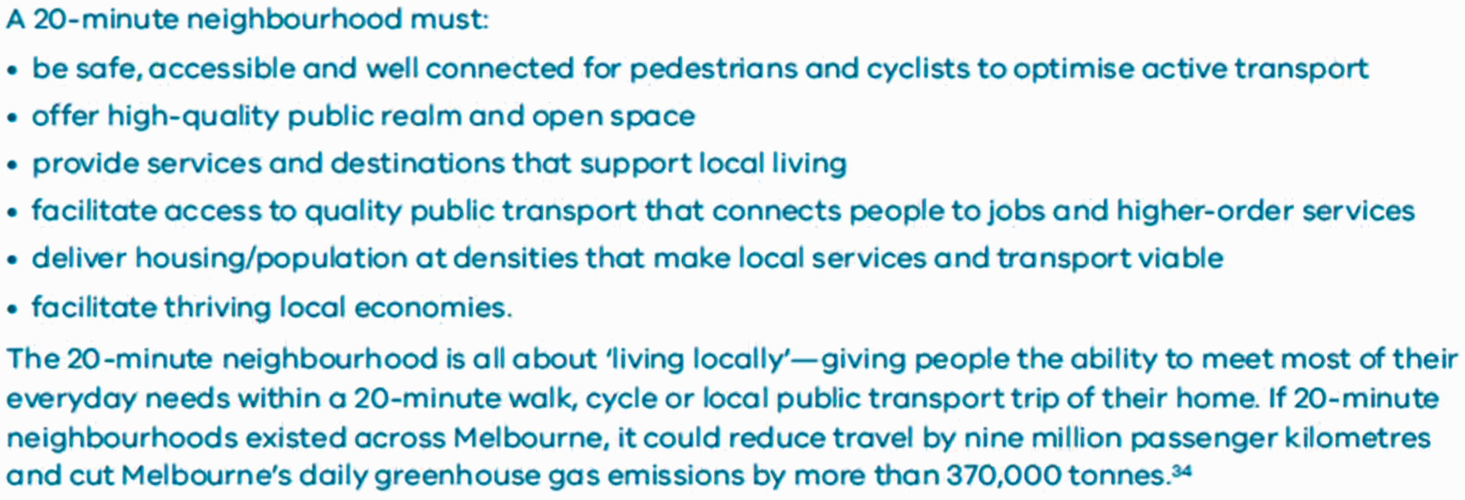
Attributes of a 20-minute neighbourhood (Victoria State Government, 2014).
In Auckland, the compact development approach incorporates objectives to improve local provision of goods, services and amenities. The Auckland Plan links this outcome with transit upgrades and intensification: ‘more compact urban neighbourhoods supported by quality networked infrastructure … such places provide a range of activities to meet the full spectrum of peoples everyday needs for work, for play, for shopping and education.’ (Auckland Council, 2013). This objective focuses on access to a variety of local goods and services at the neighbourhood or suburban level, rather than the imperative of the metropolitan-wide rescaling to efficiently accommodate future growth and shift to sustainable transport modes.
Complete communities and the variants outlined across all three cases are infrastructures of suburbanism, which directly reshape socio-spatial relations at the suburban scale to improve quality of life and convenience. Shorter trip distances and active transport modes also support public health and environmental goals by enabling more physical activity and less reliance on private vehicle travel. The uncertainty and complex spatial patterns that characterise suburban mobility systems is a challenge to relocalising suburban centres and associated travel demand to access work, local services and amenities. Travel demand is complex and difficult to predict, with competing alternatives for mobility and communication and uncertain interdependencies between spatial development and transport provision (Bertolini, 2012). This uncertainty is irreducible, and mutual reinforcement between land use patterns and infrastructures create obduracy to infrastructural and behavioural change (Hommels, 2005).
This unevenness is particularly evident in Auckland where suburban centres, even those well-served by public transport, face ongoing pressures to accommodate private vehicles. Figure 3 shows the provision of off-street parking in New Lynn, a suburban centre in west Auckland. Local roads and parking in Auckland are planned by the metropolitan authority’s transport agency, which also owns off-street parking facilities in New Lynn. The transport agency’s Parking Strategy (Auckland Transport, 2015) aims to reduce dependence on car travel but also acknowledges that many businesses rely on on-street parking to provide access for customers and allow loading of goods. As a result, infrastructure systems typically provide ‘too much and too little’, with oversupply to some areas, and deficits in others (Keil, 2017). Retrofitting suburbs with transit and active travel infrastructures is prone to this phenomena, given the substantial capital cost and time required to upgrade physical infrastructure.
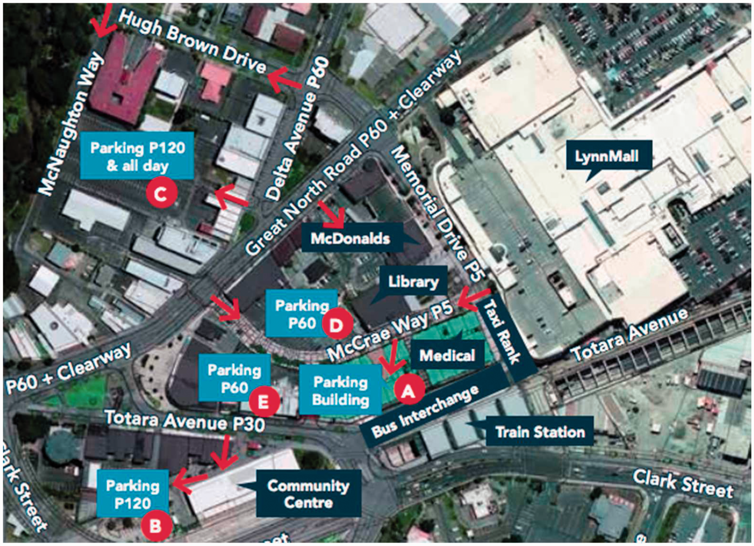
New Lynn Parking Guide (Auckland Transport, 2013).
Gateways: International and national logistics hubs
International and national ‘gateways’, in the form of sea and airport infrastructures and associated precincts of commercial and industrial land, are the third infrastructural modality identified across the three cases.
Logistics and transport nodes are prioritised as functional spaces to enable the movement of people and goods in, out, and through the city. Auckland’s plan identifies the city as ‘New Zealand’s gateway to and from the rest of the world’ on account of the international airport, seaport, transport and freight infrastructures. The mobility of goods is a particular focus: the plan highlights that 46% of the country’s trade (by value) passes through Auckland International Airport and the Port of Auckland (Auckland Council, 2013). These two major infrastructures ‘contribute significantly to economic growth and opportunities in Auckland and New Zealand’, and the plan has specific directives to protect the operations of Auckland Airport and related enterprises.
Melbourne also identifies itself as a nationally significant transport hub. The Port of Melbourne is the largest in Australia and, alongside several smaller sea and airports, identified as a ‘transport gateway’ that is ‘protected from incompatible land uses but adjacent complementary uses and employment-generating activity will be encouraged’. Auckland describes these gateways in similar terms – ‘critical to the state’s economy … providing access to local, national and international markets and are key areas for employment for economic activity’.
Vancouver adopts the same language of gateways and regional connectivity, identifying the metropolitan area as a ‘key gateway location’ – as a ‘resource rich province with strong gateway links to the North American and Asia-Pacific regions’. Availability of adjacent land for transport-related industrial and commercial uses is emphasised to support these gateways, with zoning and protections in place to ensure adequate land supply.
These higher-order infrastructures exist as infrastructures of suburbanisation, as they are essential to support the flow of imports and export goods, and people that are necessary to support suburban development and everyday practices. While ports do not solely serve suburban activities, their role in accommodating import of consumer goods and motor vehicles is crucial to enable suburban lifestyles. The Port of Auckland exemplifies this function: the port received 297,000 imported vehicles in, 2017 (Ports of Auckland, 2017), and a significant share of Auckland’s waterfront space is storage space for vehicles awaiting processing, as shown in Figure 4.

Vehicle imports awaiting processing, Port of Auckland, with downtown heritage buildings in the foreground. Image: Stuff (2015).
In each of these cases, the cities rapidly grew as trading centres during colonisation, supported by port infrastructures and both domestic and international trade. Following the urban economic transformations that saw heavy industries peripheralised or outsourced altogether to other regions or countries, downtown ports exist as a remnant of the historic economic driver of urbanisation. The growing negative externalities of port infrastructure in urban areas, in the form of air and noise pollution and the opportunity cost of land occupied (OECD, 2014), create public tensions around the desired use of these sites and ongoing necessity to locate port infrastructures near the centre of cities.
Changes in logistics technologies, such as containerisation, reshape the geography of global logistics (Cidell, 2011) and allow a reorganisation of transport infrastructures within metropolitan areas. Inland ports, found in Melbourne, Vancouver and Auckland, shift the processing functions of seaports to secondary sites to reduce congestion at waterfront locations. This reconfiguration allows expansion of port activities without increasing land use in constrained waterfront locations (Monios and Wilmsmeier, 2013), however, it also extends port activities to peripheral areas where suburban expansion is also underway.
International airports and associated commercial areas have a functional role in providing the imported consumer goods to support suburban lifestyles, yet their substantial physical presence also marks them as infrastructures in suburbs. Figure 5 shows Melbourne Airport Business Park and the adjacent suburbs.
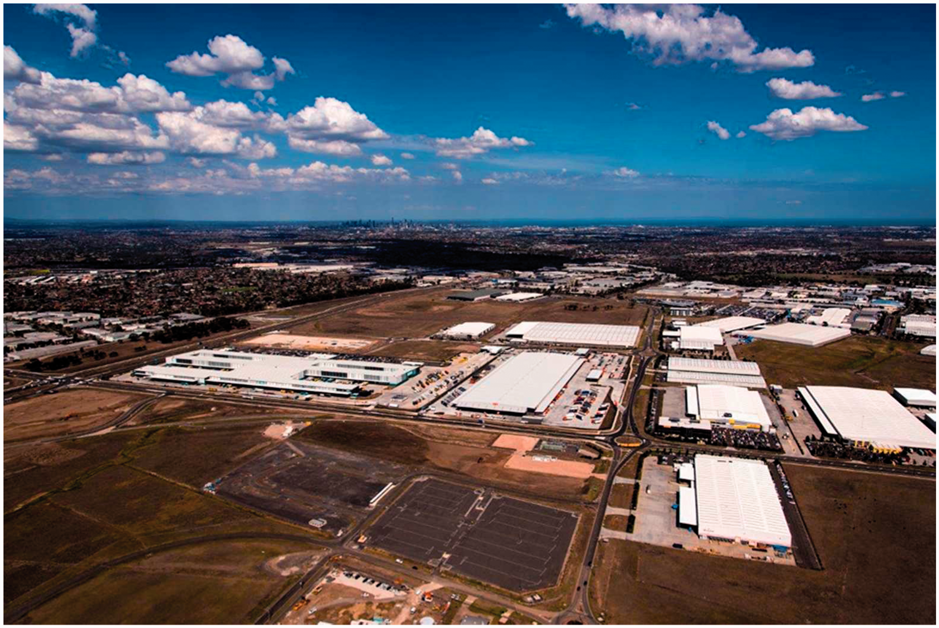
Melbourne Airport Business Park. Image: North Projects (2016).
The substantial space requirements, noise pollution and dis-amenity of aviation activities mean that airport construction is only physically and politically feasible in peripheral areas. Locating at the periphery allows airports to include buffer zones and also to develop adjacent precincts for commercial or industrial land uses. For example, Melbourne’s Tullamarine Airport adopted the ‘airport city’ form of planning (Chandu, 2017), where non-aviation land uses are a critical revenue source to be secured for the long-term financial viability of the airport.
However, the value of the airport as an financial investment lies in tension with the potential use value of peripheral land as the incremental expansion of outer suburbs begins to encroach on airport ‘buffer zones’. In Melbourne, plans to restrict outward expansion at the metropolitan fringe were later overturned by political decisions to incorporate non-urban areas into urban growth zones (Buxton and Chandu, 2016).
These tensions show that gateway infrastructures – whether they are embedded at waterfront or city-fringe sites, or at secondary locations in peripheral suburban areas – are functionally necessary to support suburban development but also embedded in suburban space. Financialisation and private ownership of these infrastructures create further complexity as their land requirements are expanded by financial models such as ‘airport city’, requiring even larger spatial footprints for financial sustainability.
Infrastructures for housing affordability
The fourth modality identified is the configuration of interventions to support the delivery of affordable housing. For each case, the institutional mandates for the direct provision of social housing lie with higher tiers of government and housing development is predominantly left to the private market. The need for housing affordability is evident across all three cases, which are among the most unaffordable cities in the world 2 : the median multiple is 11.8 in Vancouver, 10.0 in Auckland and 9.5 in Melbourne (Demographia, 2017).
The Auckland Plan sets out to ‘make Auckland both a quality and affordable place, including affordable housing, transport and other costs of living, and doing business, so that people have the choice to live, work and invest here’. This claim links affordable housing (among other living costs) as important for quality of life, as well as attracting or retaining workers and investment in the area. The strategy proposes intensified residential and mixed-use developments to provide ‘A healthy supply of high-density housing has the potential to address the challenge of housing affordability, through efficiencies in land use and infrastructure provision’. Melbourne highlights ‘housing affordability, the types of housing available to cater for different household needs and lifestyles, and the provision of medium- and higher density housing close to jobs and services. Another pressing issue is the growing number of homeless people and households waiting for public housing.’ Vancouver’s plan identifies that ‘affordable housing with a range of housing options is an essential part of complete communities’, and similar to Auckland, targets ‘higher densities and intensification [to] provide a diversity of (more affordable) housing options’.
Table 4 shows the dominant modality to address affordable housing. These interventions span include both higher-order infrastructures embedded in suburbs, and infrastructures governed by suburban-level institutions – such as local planning codes and zoning. Mediatory infrastructures, primarily the expansion of suburbs into new greenfields areas at the urban periphery, act to incorporate new areas into the metropolitan area.
Infrastructural modality – affordable housing.
Affordable housing is a key infrastructural need, but the dominant modality across the three cases uses relatively weak interventions to support this outcome. In part, this is due to the institutional separation of housing responsibilities, as social housing is the mandate of higher tiers of government in all three cases. Without the authority to directly provide affordable housing, strategic spatial plans instrumentalise local planning codes and development incentives to encourage medium- to high-density developments, in an effort provide more affordable housing options.
Examination of the way that these infrastructural interventions are governed and embedded within socio-spatial relationships shows several inherent conflicts.
Table 4 shows that planning codes are infrastructures of suburbs. Involvement of existing suburban communities in approving proposed intensification implies that the interests of existing residents strongly influence zoning changes (or lack thereof), where it lies within existing residential suburbs. Suburban opposition to intensification is typical in low-density cities (Buckenberger, 2012; Vallance et al., 2005), although other factors including land banking and investment speculation can also slow the rate of intensification (Woodcock et al., 2011). Therefore the governance of local intensification is contradictory to the desired goals of accommodating growth across multiple suburban sub-centres.
Two higher order interventions are used to incentivise development: rapid transit improvements to enable transit-oriented development and the expansion of existing suburbs into peripheral areas. The tendency for suburban communities to oppose intensification puts further pressure on redevelopment in brownfield areas to accommodate anticipated growth (Davison et al., 2016). Peripheral expansion increases travel demand and can be expensive to serve adequately with public transport services, while also drawing opposition from environmental groups. Promotion of transit-oriented development without robust affordability requirements can undermine affordability objectives by increasing housing stock without ensuring new dwellings are genuinely affordable, relative to local incomes. For example, the redevelopment stimulated by Vancouver’s SkyTrain rapid transit line encouraged a shift toward public transport usage and high-density living. Intensification along the SkyTrain line illustrated in Figure 6, replaced low-rise apartment housing with high-end condominium developments that were unaffordable for existing residents in a process interpreted as ‘state-led gentrification’ (Jones and Ley, 2016).
Condominium developments under construction near Brentwood Station, Vancouver Skytrain. Image: The West End (2016).
The ongoing growth of property values in each city suggests that compact development alone, without stronger price controls, are not an adequate solution for housing affordability. Given the contribution of external factors such as low interest rates and foreign investment (Aalbers, 2015; Ley, 2017), the limited capacity of local authorities to take direct action is a significant barrier to the transformative change that strategic spatial planning aims to enable. Debates over how to problematise and address the housing crisis in each case have become highly politicised and susceptible to policy capture (Gurran and Phibbs, 2015; Murphy, 2016), suggesting that institutional changes or significant political changes at the national or state level may be necessary to bring meaningful change to housing affordability.
Discussion
Analysis of the infrastructural modalities from strategic spatial plans produced for three metropolitan areas develops more nuanced understandings of infrastructure’s duality as both physical artefact and internalisation of political-economic processes. The cases compared represent a narrow subset of cities and the findings do not generalise across cities globally but are nonetheless useful to explain the coupled traits of Auckland, Melbourne and Vancouver: cities that are geographically isolated but are similar in terms of economic prosperity, demography, cultural preferences and modes of governance. The use of planning documents as cases for comparison limits the scope of interventions to those provided by the metropolitan or state authority. Less formalised infrastructures proposed by Addie (2016) are not represented, such as community and lobby groups, private developers’ strategies and global regulatory agreements, although they are important to shape nature of urban development. Nonetheless, the restricted scope of these documents still allows examination of the perceived role of infrastructures within spatial strategies.
The dominant approach to intensify and re-scale socio-spatial relations broadly follows the compact city paradigm, utilising urban containment, localised intensification and transit provision to support economic, environmental and social goals. Unpacking this approach revealed how it uses mediatory infrastructures embedded in suburban areas to steer spatial transformation by re-integrating suburbs into metropolitan labour markets (through transit provision) and expanding the capacity of suburbs to accommodate growth. Concomitantly, these interventions included higher-order interventions embedded in suburbs, with large-scale rapid transit upgrades and urban containment boundaries. Overlaying automobile-dominant suburbs with expanded transit networks creates uneven development, with oversupplies and deficits across suburban areas (Keil, 2017).
The strategy of localised intensification along transit corridors faces strong barriers as suburban communities can oppose further development, leading to uneven growth with most higher-density housing and mixed-use developments concentrated in brownfield areas, and suburbs with less civic capital. Land development of this nature leads to an increasingly complex built environment, characteristic of the ‘splintering urbanism’ described by Graham (2000): ‘the uneven emergence an array of premium networked spaces’. The local political constraints on development in existing suburbs, in tandem with the rollout of transit upgrades and consequent gentrification of locations with improved connectivity, drive complex interdependencies to create the network of premium spaces outlined by Graham, creating a bypass effect for the intervening areas. The complex interplay between property development, mobility provision, and travel demand to access metropolitan labour markets and local goods markets, limits the effectiveness of ‘complete communities’ as an infrastructural modality. While re-localising the provision of goods and services is beneficial to improve quality of life and public health outcomes, it is at odds with the drive for economic agglomeration of labour markets to the city centre and suburban centres.
Housing affordability emerged as the main challenge across all cases. The infrastructural modality intended to address severely unaffordable housing lacked the mandate to provide affordable housing directly. The cascading effect of the affordability crisis undermines other policy goals. Intensification in existing suburbs is difficult to deliver through planning processes where communities oppose higher-density developments. There are drivers to exploit lower-value land at the urban periphery to provide affordable housing. This alternative, in turn, challenges the imperative to increase accessibility and agglomeration of employment in the central city by locating residential areas further away, and creating travel demand that is very expensive to support with rapid transit infrastructure, and unsustainable to support with automobile-dominant systems. This reveals the complexity of urban development, and insufficient tools for direct provision of affordable housing have implications for all spatial strategies. Reliance on planning codes and expansion of land supply puts pressure on existing suburbs and the metropolitan periphery to accommodate residential development. This results in uneven development along existing transit corridors and inevitable pressure to expand outside the containment boundary to exploit cheaper land. Suburban areas are brought into conflict with peripheral ‘gateway’ infrastructures and challenges for ‘complete communities’, economic agglomeration in the city centre and suburban centres, and desired shifts to public transport, walking and cycling modes.
Infrastructure assets or networks that operate as financial investments as well as public resources face distinct tensions between the logic of financialisation and the public value of infrastructures (Johns, 2011; O’Brien and Pike, 2017). This tension is strongest for privately-owned or corporatised assets such as airports and seaports, and their claims on surrounding land and connecting transport infrastructures to support logistics and freight (Wachsmuth, 2017). If growth continues for these city-regions, the tensions between infrastructural modalities, both in suburbs and through suburban processes, will continue to affect economic growth, quality of life, and environmental sustainability.
Conclusions
Comparative analysis of strategic spatial plans unpacked how infrastructure is instrumentalised within planning strategies, to reflect on infrastructure’s dualistic nature, different forms of agency and the complex inter-relationships with urban processes and socio-spatial relationships. The findings bring greater clarity to the complexities of spatial development and highlight opportunities for the strategic mobilisation of infrastructure to support sustainable and equitable growth.
Private sector housing delivery, international logistics networks and processes of financialisation profoundly influence urban spatial development. However, they are all outside the control of authorities developing strategic spatial plans. The relatively limited authority of local authorities to exert control over the type and extent of land development is evident in this analysis. Expanding the mandate of local governments to directly provide affordable housing, at a scale and rate that meets growth needs, would dramatically improve outcomes for households, with additional benefits for local labour markets.
In light of the infrastructural modalities analysed, strategic spatial planning should engage directly with the risks and tensions between these strategies. In this way, plans can proactively identify and respond to external risks and uncertainties, particularly those resulting from limited authority or capacity at the metropolitan or local scale.
Infrastructural modalities tend to focus on population density and transport mode share. Developing targeted strategies that focus on the users of infrastructure is also needed to improve the outcomes for individuals, households and firms by acknowledging their diverse needs. Identifying the variety of user needs is necessary to support local labour markets, peak-hour commuters as well as off-peak travellers, elderly and mobility-disadvantaged populations. This is particularly relevant for walking and cycling infrastructures, where uptake is heavily biased toward certain user groups (Aldred et al., 2016). Finally, the instrumentalisation of infrastructure within these spatial plans aligns poorly with the delivery modes of infrastructure projects. Infrastructure delivery encompasses project appraisal, engineering design, legal and financial considerations. Stronger engagement with infrastructure practitioners may be helpful to develop a strategy for embedding planning objectives across different stages of the project life cycle, from planning and appraisal, through to delivery and the operating phase.
All three cases illustrate how infrastructures mediate the complex interdependencies between the city centre and suburbs. The findings can inform the development of national urban policy as well as spatial strategies developed at the metropolitan or local scale. Urban infrastructure systems can either act as barriers or enablers for transitions to environmentally sound and socially equitable urban growth. To mobilise the transformative potential of infrastructure, strategic spatial planning must be accompanied by sufficient authority at the local and metropolitan level, adopt a user-focused approach to infrastructure planning, and engage directly with the technical and political modes of infrastructure delivery.
Footnotes
Declaration of conflicting interests
The author(s) declared no potential conflicts of interest with respect to the research, authorship, and/or publication of this article.
Funding
The author(s) disclosed receipt of the following financial support for the research, authorship, and/or publication of this article: This research was supported by funding provided by Auckland Council (13784), the governing authority for Auckland, New Zealand.