




Abstract
Disaster risk zonation is often proposed as a long-term disaster risk reduction strategy by international treaties and academic research. This strategy has been implemented in the city of Limbe, which is known to be a disaster-prone one. Citizens are forced to settle in unsafe terrains, ranging from wetlands to unstable hillslopes due to the city’s geographical location and economic attraction. Following the fatal landslides and floods in 2001, a local crisis committee identified affected areas and declared them ‘risk zones’ to prevent further exposure. Empirically, this study narrates the production and implementation of risk zonation policy in the city of Limbe. Theoretically, it uses an urban political ecology perspective, which incorporates science and technology studies, post-political theory and disaster research to interpret the drivers and implications of the mismatch between research, policy and action. In this case study, we investigate the implications for disaster risk reduction by describing three underlying socio-political drivers of the risk zonation policy: (i) authoritarian science regime, (ii) post-political discourse, and (iii) blame diversion. We argue that authorities from national to local level use a post-political discourse to promote and implement disaster risk reduction in the city of Limbe through the development and the application of risk zonation policy. As a consequence, risk zonation leads to poor enforcement of the law and corruption, ultimately leading to risk accumulation in this case. This analysis allows us to draw broader conclusions on drivers and implications of the implementation of disaster risk zonation policy in urban areas that are primarily governed hierarchically and prone to corruption.
Keywords
Introduction
Limbe city, located in South-West Cameroon at the footslopes of Mount Cameroon, is known, both internationally and nationally, to be prone to natural hazards. In the words of an NGO representative active in Limbe: ‘If the sea doesn’t overflow it is the mountain that erupts, so we are always on an alert’ (Interviewee A, Personal interview). In contrast, the city has an economically attractive and growing urban centre. Therefore, a risk zonation policy is being implemented to protect Limbe’s citizens from suffering.
Risk zonation policies are often recommended as disaster risk reduction (DRR) strategies by academic research (e.g. Wamsler, 2006) and international treaties on DRR (e.g. Sendai Framework, article 27K: UNISDR, 2015b: 14). According to Fell et al. (2008: 86), risk zoning is ‘the division of land into homogeneous areas or domains and their ranking according to degrees of actual or potential [hazard] risk or applicability of certain hazard-related regulations’. Depending on its purpose, this zoning is made at a regional, local or site-specific scale (Fell et al., 2008) and it is visualised in the form of maps, e.g. susceptibility, hazard or risk maps (Fell et al., 2008). Risk zonation policy refers to the regulations which apply to certain zones of high risk. These regulations include zoning, use restrictions, maintenance requirements, and development standards (DeGraff, 2012). In other words, disaster risk zonation policy is a form of ‘land use planning’, meaning: the process undertaken by public authorities to identify, evaluate and decide on different options for the use of land, including consideration of long term economic, social and environmental objectives and the implications for different communities and interest groups, and the subsequent formulation and promulgation of plans that describe the permitted or acceptable uses. (UNISDR, 2009: 19) a methodology to determine the nature and extent of risk by analysing potential hazards and evaluating existing conditions of vulnerability that together could potentially harm exposed people, property, services, livelihoods and the environment on which they depend. (UNISDR, 2009: 26)
An important discrepancy between policy and practice thus exists. The main objective of this research is to offer a better understanding of the political and economic rationale underlying the weak implementation of risk zonation policy, which leads to the current mismatch between policy and practice. By examining how risk zonation policy is used as a post-political ‘camouflage’ in the case of Limbe city, this study contributes to explain the reasons why risk zonation policies are often one of the first DRR strategies to be implemented, albeit in some cases with perverse consequences. While the implementation of a risk zonation policy gives the impression that governments concentrate on the protection of their citizens, in practice a post-political discourse is used to avoid potential blame. This study argues that in cases where these policies are used as a camouflage, they are likely to increase instead of reduce disaster risk.
In this study, we first propose an analytical framework combining three strands of literature to enrich the research field of urban political ecology (UPE): disaster research, discourse theory, and science and technology studies (STS). We then introduce the case study of Limbe city, South-West Cameroon, and present the analysis of the origin and implementation of its disaster risk zonation policy based on empirical observations. We specifically focus on analysing the socio-political drivers that underlie the mismatch between the presence of hazard maps and risk zonation policy in Limbe city, on the one hand, and the absence of true enforcement, on the other hand. This study concludes by considering the consequences of this mismatch for DRR.
The urban political ecology of disasters
Limits to disaster research
Disaster research has gone through various paradigms throughout history. Furedi (2007) identifies three key shifts in disaster ‘thought’: disasters as ‘Acts of God(s)’, ‘Acts of Nature’ and ‘Acts of Humans’. First disasters were explained as Acts of God(s), implying humans’ incapacity to act (Manyena et al., 2011). Later, the emphasis on science – especially since the Enlightenment – redefined disasters as Acts of Nature and, by doing so, shifted disaster research to hazards. Since the 1970–1980s, political economists have been challenging this so-called hazard paradigm (e.g. Watts, 1983) by looking at disasters as Acts of Humans (Manyena et al., 2011). Different social scientists have since then criticised the focus of the hazard paradigm on bio-physical factors and technocratic interventions for neglecting the fundamental socio-political causes of vulnerability (Bassett and Fogelman, 2013). It is argued that merely focussing on the hazard, the damage it provokes, and how this damage might be reduced through better planning (Bassett and Fogelman, 2013) is insufficient. The current dominant discourse in disaster research and practice, supported by the World Conferences on DRR in Hyogo (UNISDR, 2005) and Sendai (UNISDR, 2015b), acknowledges disasters as acts of both humans and nature; yet the hazard paradigm still lingers on and resurfaces at times. For example, most disaster research remains focussed on the hazard itself (e.g. Maes et al., 2017 for landslides; Gall et al., 2015; Pelling, 2001, for natural hazards in general). The technocratic approach has thus never really disappeared in disaster practice, partly because the humanitarian community is reluctant to engage with political and development matters (Hewitt, 2015; Pelling and Dill, 2010). Other reasons relate to the fact that most institutions for disaster risk management were established during the – high tide of the hazard paradigm – Cold War and the hesitance of decision-makers to invest in actions without tangible results. An increasing post-political era might also partly explain this resurfacing, as we will discuss later on.
Bearing this in mind, this study responds to those calling for an enhanced understanding of the socio-political drivers behind disaster risk accumulation which is still increasing despite global agenda’s and protocols for DRR (UNISDR, 2015a). This study therefore brings on board UPE, as discussed below, to uncover the underlying socio-political dynamics leading to the failure of current DRR policies.
Urban political ecology meets disaster research
Evolution of urban political ecology research
UPE studies the production of urban nature through the metaphor of ‘urban metabolism’ 2 (Heynen, 2014). This urban metabolism refers to the complex relations between nature and society, including the unequal access and control over resources and their implications for people’s livelihoods and their environments (Watts, 2000).
According to Heynen (2014), the notion of urban metabolism is evolving from a ‘first wave’ UPE into a ‘second wave’ and this is due to at least three theoretical innovations. First, STS have enriched UPE’s notion of urban metabolism, by demonstrating and theorising the ways in which scientific knowledge is produced, circulated and applied. A second theoretical advancement has broadened the focus of UPE beyond cities into urbanising areas, advancing the understanding of urbanisation processes (Gustafson, 2015). Third, this emerging second wave is moving away from ‘resource domains’ (e.g. water) into more systemic geographic themes (Heynen, 2014), including for example disaster research (e.g. Blackburn, 2014; Gustafson, 2015; Manyena et al., 2011). The following paragraphs illustrate some insights from STS and political theory which are deemed crucial for analysing our case study and enriching UPE.
Insights from science and technology studies and political theory
While commonly positivist scientists claim to be objective, Science and Technology scholars stress that assumed ‘objective’ scientific insights are inevitably influenced by a variety of social and cultural factors (Robbins, 2012). Pestre (2003) highlighted how politico-economic forces shape the formulation of research questions that are investigated and funded, as well as how research output is circulated and applied. Hence, new relations among scientists, states, and economic elites form a distinctive ‘science regime’ (Pestre, 2003).
Whether science is perceived as objective and non-political or instead as a socio-political construction, it is impossible to deny that scientific insights are used politically and mobilised in discourses held by state and non-state actors (Kenis and Lievens, 2015). At first glance, the scientific claim of neutrality and objectiveness appears to be a-political, yet in reality this claim hides subtle yet strong political effects. It provides a superior position for one party, i.e. more legitimacy and credibility, over the other (Heynen et al., 2006). Political theorists use the terms ‘post-political’ or ‘depolitisation’ to refer to this tendency to develop forms of cooperation beyond existing tensions for illegitimating or obscuring conflict and resistance (Ferguson, 1985; Marchart, 2008; Mouffe, 2005), e.g. consensual agreements between politicians, scientists and/or citizens. This article distinguishes the ‘political’ from conventional politics. The ‘political’ refers to discourses or representations that can make power, conflict, inequality and decisions either visible or not (Marchart, 2008). For example, the claim that a certain policy agenda is beyond politics because it is based on ‘science’, economics or technology leaves limited room for disagreement or contestation. The practice of using a scientific, neutral claim in the public realm easily leads to forms of technocracy that have been conceptualised as post-political (Kenis and Lievens, 2015). Using a post-political discourse is thus referring to the engagement in political activities under the guise of implementing non-political – seemingly technocratic reforms (Ferguson, 1985). Kaika (2017) argues that technocratic strategies are increasingly resurfacing as a panacea for solving socio-environmental problems. This increased technocratic logic can be explained by a rising post-political era, at least in democratic polities protected by technocratic logics with almost uncontested hegemony 3 (Mouffe, 2005). Furthermore, Hood (2002) claims that technocratic logics can be used as a blame shifting tactic by governments. Similarly, Ferguson (1985) showed how such technocratic logics can cause development projects to fail before their start. Sub-Saharan African countries are particularly concerned by larger impact of international policies (Holloway, 2012) and thus by the resurfacing of a post-political discourse.
Linking STS, disaster research and urban political ecology
The dominating technocratic logic is also present in disaster research and politics (Kaika, 2017). This study has reported above how this resurfaced hegemony of technocratic logics in disaster research and policy has historical roots. Pearson and Pelling (2015) argue that intergovernmental negotiations were more present in the Sendai than in the Hyogo Framework. As a result, one could argue that an increased post-political discourse is finding its way in the international DRR agenda.
Through combining disaster scholarship, political theory and STS within UPE, this study develops an analytical framework to study the socio-political drivers behind the mismatch between policy and practice of disaster risk zonation in Cameroon, as well as to understand its consequences. By investigating both socio-political drivers and physical consequences, this study tries to go beyond the critique on UPE of being primarily occupied with ‘the political’ and relegating ecology and environmental changes to the background (Penna-Firme, 2013).
Methodology: A case study approach
This research studies the case of Limbe, a city located in South-West Cameroon and affected by landsliding and flooding, to understand the political ecology of risk zonation policy in Cameroon. We follow an integrated approach to disaster risk. According to Gall et al. (2015: 255), integrated disaster risk research – in its broadest sense – can be defined as ‘studies that engage multiple scales, stakeholders, knowledge (scientific to indigenous), disciplines, and methods’. Accordingly, we employ different methods, at various scales, involving different actors, and embedded in an analytical framework which draws from different disciplines. We developed a case study research approach, meaning ‘an in-depth exploration from multiple perspectives of the complexity and uniqueness of a particular project, policy, institution, program or system in a real life context’ (Simons, 2009: 21). We interpret case study research not as a method in itself, but rather as a ‘design frame’ that may consist of several methods (Thomas, 2011). The case study approach allows to answer crucial ‘how’ or ‘why’ questions about contemporary issues, while unobtrusive approaches such as surveys and archival research favour ‘what’, ‘who’ and ‘where’ type of questions (Yin, 2003). By embedding this case study approach into an enriched UPE analytical framework, this methodology enabled us to investigate and conclude on complex interactions, institutional models and practices that shape disaster governance in Limbe city. A qualitative research approach was thus used, based on four data collection methods: focus groups, semi-structured interviews, secondary data collection and a household survey. The data corresponding to the first three methods was collected in the summer of 2015 during a fieldwork period of five weeks in Limbe and Buea carried out by the lead author of this paper; the household survey was conducted and analysed in the framework of the second author’s PhD research.
Firstly, secondary data on Limbe city and risk zonation for landslides and floods were collected and analysed. These included national laws and orders, hazard maps produced by different projects, and urban development plans.
Secondly, information on perception of risk zonation was gathered through 20 semi-structured interviews with representatives of local and national authorities, NGOs, scientists and citizens living in so-called ‘risk zones’ (Appendix 1).
Thirdly, seven focus groups were held, including one with local authorities (Limbe I) and six with local communities on the development and implementation of risk zonation policies. Three focus quarters with risk zones were selected for this: Unity Quarters, Mabeta New Layout and Mbonjo quarter (Figure 1). For each quarter, two focus groups were held in order to enhance open discussion: one with women and one with men. Each focus group consisted of nine to ten participants.
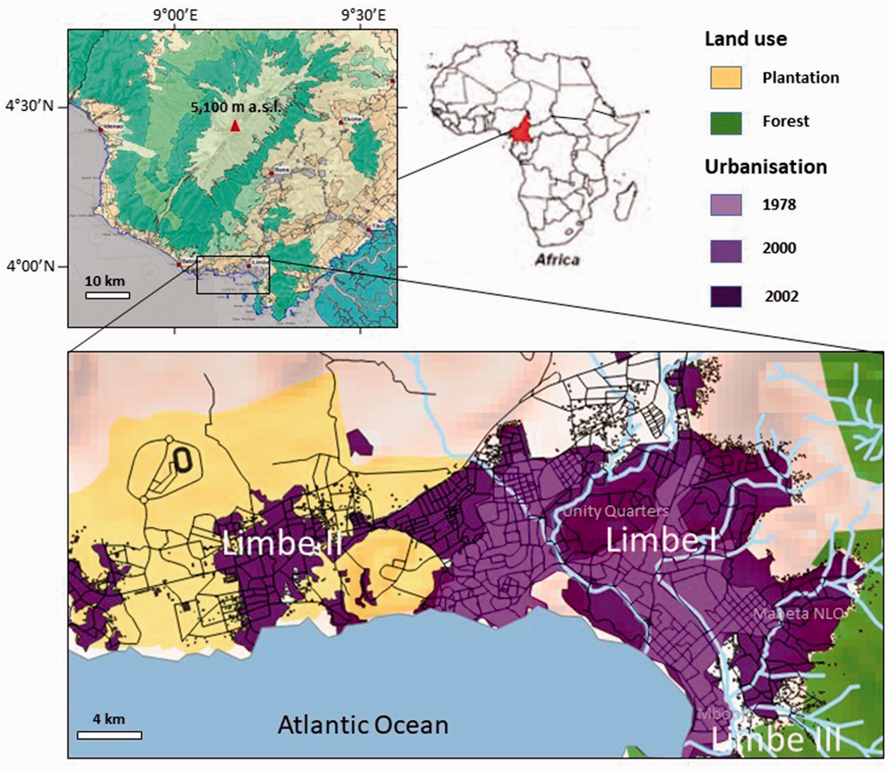
The location of Limbe city in South-West Cameroon.
Fourthly, a household survey was conducted to compare the perceived evaluation of quarter facilities provided by the government, between citizens living inside and outside so-called ‘risk zones’ of Limbe. It consisted of 187 households sampled amongst several quarters in Limbe. A multi-stage sampling procedure was followed to select interviewed households. The stratified sampling technique started with categorising the various quarters according to location, geophysical conditions and socio-demographic characteristics of residents, into six quarter types. For each quarter type the most representative quarters were sampled (Appendix 2). Each sampled quarter was then subdivided into clusters, based on their relative population number to determine their sample size. Finally, households were selected from these clusters by a random sampling technique to ensure representativeness. The survey was answered by the household head of the selected household, or, in absence of the former, by another household member above 15 years old.
The validity of the collected information was checked by transcribing and coding all semi-structured interviews and focus groups (Corbin and Strauss, 2015) using NVivo. SPSS was used to analyse the survey data, applying both descriptive (i.e. frequency tables and percentages) and inferential statistical techniques (i.e. measures of association using Chi Square test of independence). In order to assess the consequences of the risk zonation policy on the exposure to natural hazards of people in Limbe, satellite images were analysed. For this analysis, buildings in Limbe were retrieved from OpenStreetMap Foundation (2016) and overlaid with so-called ‘risk zones’ from different studies in a QGIS environment.
The case study
The city of Limbe in South-West Cameroon
The Republic of Cameroon, ruled by President Paul Biya since 1982, can be considered a semi-authoritarian regime (Freedom House, 2007). Semi-authoritarian regimes combine characteristics of both democracies and authoritarian ones: ‘they adopt elements of democratic institutions and rhetorically define themselves as democracies, but in reality they fall short of meeting the basic criterion of liberal democracies, namely respect for civil and political rights’ (Tripp, 2010: 14). Cameroon is highly centralised in its politico-administrative structure and organisation. The latter is composed of five levels relevant for this research: regions, divisions, city councils, municipalities and quarters. While authorities at all levels are appointed by the central government, municipal mayors are democratically elected albeit controlled by central government delegates. Cameroon is divided into ten politico-administrative regions, including two from the former British administered territory of Southern Cameroons (North-West and South-West) and eight that consist of the former French territory of Cameroun. The latter includes the Centre Region hosting the national capital in Yaoundé.
The focus of this study is the coastal city of Limbe, a second-order city located within the Fako Division of the South-West Region of Cameroon (Figure 1). The city had an estimated population of around 120,000 inhabitants in 2010 (Limbe City Council, 2010), having one of the highest population densities in Cameroon. Since 2008, the Limbe City Council (LCC) consists of three municipalities: the Limbe I, Poh Council (54% of the total population), the Limbe II, Mokundange Council (32%) and the Limbe III, Bimbia Council (14%) (Nguh, 2013).
As in other emerging cities in the global South (Wisner et al., 2015), people in Limbe are caught in a situation of rapid urbanisation, poverty, and land scarcity. Limbe city, formerly known as Victoria, emerged in 1858 as a colonial town and owns its growth to the port and plantation economy (Tiafack et al., 2014). The native people were originally fishers, i.e. the Bakweri, yet newcomers from other Cameroonian regions became dominantly involved in the plantation economy, particularly after the nationalisation of the Cameroon Development Corporation (CDC) which had its headquarters in Limbe. This second order coastal city has been at the centre of Cameroon’s industrial development and is now the third largest producer of custom revenue to the Cameroonian government (Tiafack et al., 2014). Especially after the establishment of the national crude oil refinery company (SONARA) in 1976, rapid urbanisation took off, attracting people from the North-West region and neighbouring countries (Fombe and Molombe, 2015) which now constitute the largest fraction of the population (23.5% natives in comparison to 76.5% non-natives in our survey).
While Limbe is growing rapidly, its expansion is limited by physical geographical constraints (Che et al., 2012a; Thierry et al., 2008), as the city is located between Mount Cameroon and the Atlantic Ocean (Figure 1). Due to the protected community forest and CDC plantations respectively in the north-east and west of the city (Lambi et al., 2002), people are pushed into hazardous areas for settlement, such as the steep volcanic hills and floodplains in and around the city. The oil palm plantation estates have long contributed to the land scarcity in the city, but this pressure is decreasing due to the current CDC ‘Land Surrender Policy’, which gives the possibility to lease plantation lands for urban expansion (Fombe and Molombe, 2015). Most urban expansion is to the west (Limbe II), east and south (Limbe III), opening up the market for land speculators (Kometa, 2012).
Limbe is known, both internationally and nationally, as prone to natural hazards. The city experiences a sub-equatorial climate with a high annual rainfall varying from 1500 to 6000 mm (Che et al., 2012a). Monthly rainfall frequently totals over 500 mm and sometimes up to 1000 mm in June, July and August (Che et al., 2012a). The city is also characterised by pyroclastic cones and highly weathered lava topographies with steep slopes (Che et al., 2012b), leading to frequent landslides and yearly floods (Kometa, 2012). Adjacent to the Atlantic Ocean, Limbe is recurrently affected by coastal inundations (Molua, 2009). Moreover, the presence of the active volcano, Mount Cameroon, is another risk which manifested itself recently in lava flows occurring in 1999–2000 (Kometa, 2012). In the years 1990, 2000, 2001 and 2007, landslides and floods were so severe (i.e. exceeding 10 fatalities) that they required national emergency alerts (Ndille and Belle, 2014), especially due to the high exposure and vulnerability of Limbe’s citizens.
A recent study on risk perceptions and belief systems of people living around Mount Cameroon (Brewer, 2013) revealed that people continue taking high-risk activities – like settling and cultivating land in areas prone to landslides and lava flows – for several reasons. First, traditional beliefs about the volcano activity mismatch the explanations given by science. Second, trust in central government actions, including prevention programmes on DRR, is low (e.g. Gros, 2003). Third, the daily economic benefits for people’s livelihood and the cultural attachment to the ancestral lands usually outweigh the long-term challenges of living near Mount Cameroon. For example, the following quote from a resident of Limbe illustrates the importance given to livelihood over risks of landslides or floods: ‘The town has economic potential. People know that now. The investments will even become more’ (Interviewee B, Personal interview).
History and structure of disaster risk zonation policy
Centralised laws
Despite Cameroon’s formal commitment to decentralisation in the 1996 Constitution, most crucial policy domains including disaster risk management remain centralised at the national level (Bang, 2014; Ndille and Belle, 2014; Tanga and Fonchingong, 2009), as is the case in many African countries (PreventionWeb, 2012). More specifically, the devolution of authority, competencies and responsibilities, including human and financial resources, to lower administrative levels remains limited (Bang, 2014), which is characteristic for (semi-) authoritarian regimes (Tripp, 2010). Disaster risk management is under the responsibility of the Ministry of Territorial Administration and Decentralisation (MINATD) and follows a top-down hierarchical approach (Bang, 2014). This Ministry is the key bureaucratic agency of the ruling party in the regions, since authorities such as Regional Governors, Senior Divisional Officers (SDOs), and Divisional Officers represent both the Ministry and the ruling party at each administrative level. Whereas orders and decisions are made at the national level by national ministries, the implementation occurs at local level by technicians and politicians. Depending on the severity and phase of the disaster, local crisis commissions can be established at the regional level by order of the Regional Governor, or at the divisional level by the SDO (Bang, 2014).
Cameroon is in the process of decentralisation and therefore the responsibility and capacities for disaster risk management are slowly being devolved to the local councils (Bang, 2014). These councils (e.g. LCC) are supported technically and controlled by the ministries at divisional level to make sure that orders from the SDO (i.e. the extension of the central government) are implemented properly. In the words of a hazard scientist at the University of Buea (UBuea), this means that in practice ‘the final say is still in the hands of the national government’ (Interviewee C, Personal interview). The decision-making thus remains centralised in Yaoundé.
Risk zonation policy based on ad hoc assessment
The current risk zonation policy is a compilation of several national laws and are thus applicable to the entire country. The Town Planning Law No. 2004/003 of 21 April (Republic of Cameroon, 2004) states that any land at risk of a natural hazard shall not be built on. In addition, Law No. 80-22 of 14 July 1980 prevents infringements on land property and State Lands. According to the Environmental Management Law No. 96/12 of 5 August 1996, these State Lands include amongst others mangrove ecosystems at inter-tidal zones (Art. 94), flood plains (Art. 27), and steep hills that are prone to soil erosion (Art. 36). In Cameroon, risk zonation policy is thus interpreted as a restriction policy on settlement and encroachment in high risk zones. No strict regulation exists however on how to define these zones or whether selling and buying of land in risk zones is legally forbidden.
In Limbe, ‘risk assessments’ are conducted in parallel by the government, through local crisis commissions, and by development and research agencies. This situation leads to duplicated efforts and disconnected assessments. Table 1 presents these risk assessments for Limbe, including geo-hazard maps (Gaston, 2009; Thierry et al., 2008), flood hazard maps (Gaston, 2009; LCC, 2012; Kometa, 2012; Limbe City Council, 2012), a landslide susceptibility map (Che et al., 2012a), and an administrative map with hazard-susceptible areas called ‘risk zones’ (LUC, 2001).
Summary of risk zones in Limbe city for four hazards including reference.

The only identification of ‘risk zones’ that found its way into the policy realm was done by the 2001 local crisis commission. This commission was set up by the SDO of Fako division to investigate the 2001 landslides and floods, notably their causes and damages, and to identify risk zones (LUC, 2001). The 2001 event was exceptional for Limbe city; it displaced around 230 households and killed 93 persons (Ndille and Belle, 2014). This crisis commission included representatives from the national and local government, NGOs, research institutes, and the private sector (LUC, 2001). All these representatives were chosen by the SDO. A representative of a local NGO expressed dissatisfaction while pointing out the difficulties of getting included in this commission. A member of the 2001 commission criticised the haphazardly establishment of this type of crisis commissions as well as their lack of accountability and temporary status (Interviewee D, Personal interview). Other ‘risk assessments’ have been produced by development and research projects in the aftermath of the 2001 events, including projects such as the GRINP (Thierry et al., 2008), MIA-VITA (Apa et al., 2012), VLIR-UOS (del Marmol et al., 2017), and IRCOD (LCC, 2012).
In practice, the identification of ‘risk zones’ is a continuous process and is formalised during one of the following three ad hoc procedures (Table 2): granting of building permits by the building permit commission, granting of land titles by the land consultative board, and systematic household surveys that follow national orders (e.g. identify houses within 15 m distance of the main rivers in Limbe by Ministerial Order on 07 March 2015).
Ad hoc governmental procedures to identify ‘risk zones’ in Limbe city.
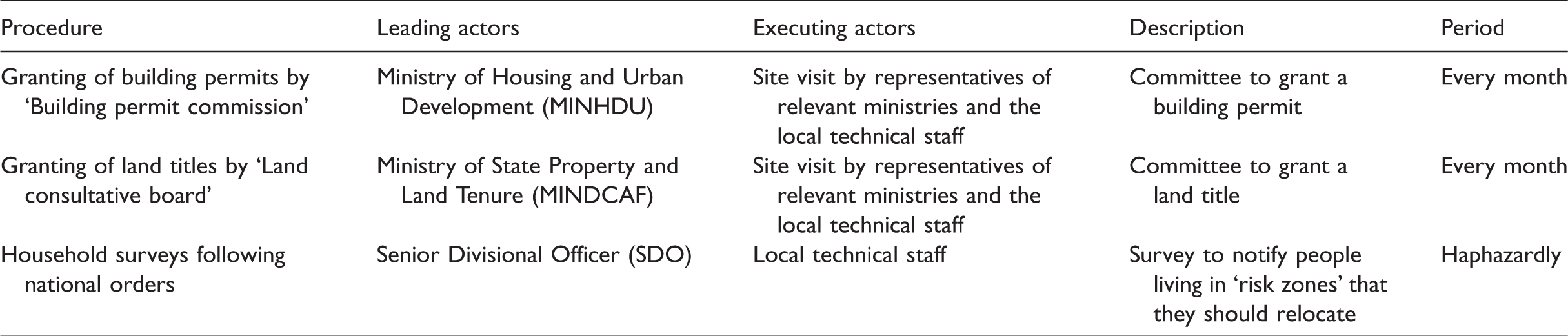
Each of these procedures involve a site visit where buildings that do not comply with standards and regulations get painted with red marks (Figure 2). In the words of a LCC staff member ‘… we know what is a risk zone, when we go on the field with the technical staff, we assess the topography and based on that we declare it risk zone and mark the house’ (Interviewee E, Personal interview). The concerned owners are then notified and requested to meet the LCC administration.
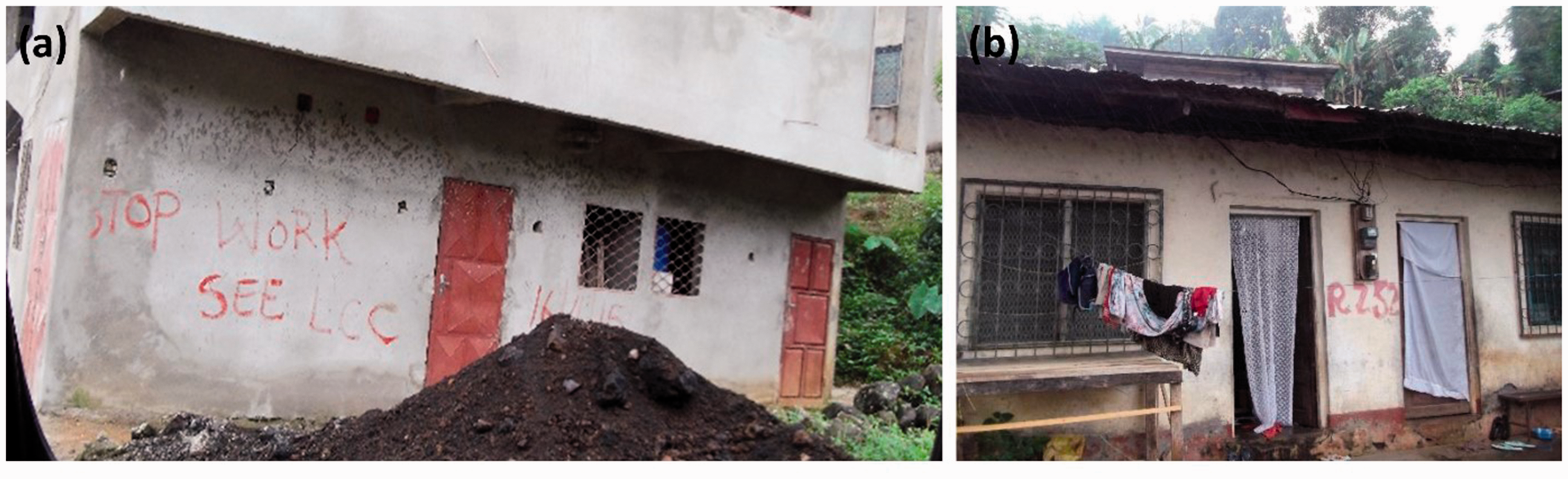
Examples of the demarcation of buildings in Limbe city by the technical staff of Limbe City Council (LCC): (a) a house without a building permit that reads ‘stop work, see LCC’ in Motowoh quarter (09 July 2015) and (b) a house within the risk zone of Unity Quarters.
Poor enforcement of the law
The risk zonation policy involves four steps towards implementation: (1) identifying houses located within the risk zones and informing the concerned people, (2) preventing any infrastructure from being built within the risk zones, (3) relocating the households living within the risk zones, and (4) demolishing houses (Ministerial Order of MINHDU, e.g. on 07 March 2015). Currently, only two of these steps are implemented, including the identification and verbal notification to the people living in risk zones as well as the prevention of new house construction through the denial of building permits and land titles. Although the evacuation and relocation of people out of risk zones was written in policy documents after 2001 and later in ordinances by the SDO, the actual implementation of the risk zonation policy does not go beyond raising awareness. This awareness building involves the one-directional communication of risk by the LCC to the communities-at-risk and occurs haphazardly. Respondents living in risk zones confirmed that it is impossible to get a land title after 2001, but building permits are however granted occasionally. The issuing of building permits in risk zones was confirmed by officials despite the so-called ban on further development. A town planner at LCC testifies: Where buildings do not comply with the standards or regulations, they get a mark [on their house]. But as long as there can be paid 5000 CFA [€7.2 in 2016] here, 10000 CFA [€15 in 2016] there, marks are washed or not put. (Interviewee F, Personal interview)
Socio-political drivers underlying the mismatch between policy and practice
Authoritarian science regime as a driver for conducting risk assessment
The numerous development and research projects in Limbe city, and thus the various ‘risk assessments’, can partly be explained by Cameroon’s shift to a neoliberal agenda after the economic downturn in the 1980s and 1990s (Gros, 2003). This agenda increased the influx of non-governmental organisations (NGOs) as the drivers for development, especially in the Anglophone regions of Cameroon (Tanga and Fonchingong, 2009). Mbembe (2001) explains that the postcolonial African authoritarian regimes are built around two processes which are the demise of the state and the privatisation of public prerogatives. According to various local administrators interviewed for this research, attracting new development projects led by NGOs is crucial given their large contribution to the income for the LCC. As a consequence, local authorities are hesitant to share the existing risk information in order to keep attracting new projects and money. The concept of extraversion is used by political theorists to explain the strategy of rent-seeking by (semi-) authoritarian regimes of sub-Saharan African countries (e.g. Bayart, 2000; Tull, 2011). Extraversion refers to the act of turning towards the outside for foreign money, i.e. seeking for dependency on foreign aid as a means to secure permanence in power (Bayart, 2000). The ‘expertise on risk assessment’ is thus not a neutral political entity (e.g. Pestre, 2003), but a strategy mobilised by political authorities. Alternatively stated, the authoritarian science regime in Limbe prevents the circulation of risk assessments in order to continue attracting donors. For example, technicians and politicians interviewed during our focus groups did not express interest when we offered to share the risk assessments of previous projects with them (e.g. GRINP and MIAVITA). Blocking the communication of risk knowledge is also a common feature of (semi-) authoritarian regimes who seek to resist any type of transformative change (Solecki et al., 2017). In fact, calling for new risk assessments facilitates the opportunistic immobility of authorities and keeps on postponing meaningful and serious actions.
Post-political discourse and blame diversion as drivers for having risk zonation policy
The observed post-political discourse of national and local authorities in Cameroon meets the needs of the state-owned industries (e.g. plantation agriculture in the case of Limbe city) instead of striving for safe settlement conditions. The impossibility to contest the power of the state-owned industries for spatial expansion over citizens’ needs for safe settlement, illustrates Cameroon’s post-political character. According to Mbembe (2001), in postcolonial countries that were reputed as stable and prosperous after independence, like Cameroon, the blurring between the strictly economic and business spheres, on the one hand, and the political and administrative ones, on the other hand, produced a governance system in which citizens were not the primary concern. The recent ‘Land Surrender Policy’ of CDC nonetheless provides some room for spatial expansion in Limbe city. As much of the remaining land is unsafe for settlement, risk zonation is used by national and local authorities to avert their responsibility for protecting their citizens from hazards in two ways.
First, policy documents and interviews show that risk zonation enables the national and local authorities to present the problem of disasters as technical and non-political. As such, the responsibility is diverted to the technical staff of the LCC or even dissolved within the process (e.g. Hood, 2002). This shift of responsibility from politicians to bureaucrats is described by Fiorina (1982) as the shift-of-responsibility model. This shift is explained by the fact that politicians fear to be blamed for not sufficiently planning for disasters but also remain able to take credit in case of a positive outcome. Technical staff however might have limited incentive to enforce the laws or make right decisions in uncertain situations because they are unlikely to be held accountable in case of disaster. According to a LCC representative, this technocratic approach reflects the common disaster discourse in Limbe, as the other main DRR strategies consist of regular dredging of the two main rivers in Limbe and enforcement of building codes by the technical staff of the LCC (Interviewee G, Personal interview). Building on political theory (Ferguson, 1985; Mouffe, 2005), this paper argues that risk zonation policy in Limbe follows a post-political discourse: national and local governments present risk zonation as a pure technical and a-political issue for which finances and enforcement means are limited. This post-political discourse is for example illustrated by the following statement of a government delegate of Fako division: You don’t have to worry about political sensitive issues. As long as you talk about risk zonation this is not sensitive. This is not a political issue, it is just administrative. If you ask what influences decision-making on where to put risk zones, this is purely administrative. (Interviewee H, Personal interview)
Second, people are tolerated to construct in risk zones at their own risk. Both officials and residents of risk zones acknowledged the fact that settlement was unofficially allowed if the resident agrees to live in this area on his/her own responsibility. As people have the unofficial approval to settle in risk zones at their own risk, the responsibility to reduce disaster risk is shifted from the government to the people who live in risk zones. People-at-risk are thus blamed in case a disaster occurs. This shift of responsibility is in fact the easiest way for the government to escape from being blamed, as illustrated by the words of a Cameroon Red Cross employee: …when something happens and the government did not act, the government will be blamed for not acting. If the government uses force [to relocate people] then the government is wicked. (Interviewee J, Personal interview) They [the government] don’t push you out but they just don’t want to take the blame for anything that might happen. They don’t want to be responsible. Like this, people cannot come and say, hey you have granted me a building permit and now this happens. (Interviewee K, Personal interview)
Post-political discourse as driver for poor enforcement of the law
The reasons for national and local governments to avoid evicting people or demolishing houses are plenty. First, authorities do not wish to face political risks (e.g. losing potential votes) and economic loss (e.g. time and money spent) of demolishing houses and providing alternative housing. Second, poor enforcement of the law gives the local government opportunities to benefit financially through corruption, which is common in Cameroon (Transparency International, 2013). Corruption is facilitated by face-to-face interactions during the ad hoc risk assessments, the lack of transparency on risk zonation policy (e.g. not based on transparent but ad hoc assessments), and the ill-definition of ‘risk zones’. Instead of understanding corruption in terms of institutional deficits and weak state capacities, we thus explain corruption as an inherent and locally useful part of power (Tull, 2011). Third, it frees the governments from their responsibility to provide public services in these areas or compensate people if they are affected by a disaster. Fourth, it allows to maintain the availability of cheap labour force within the city, favouring local state-owned industries (e.g. CDC). Paraphrasing Susman et al. (1983) on the explanation of marginalisation, this labour force is kept cheap, vulnerable and dependent by means of restricting facilities and denying access to land titles, building permits and loans. All these socio-political incentives thus favour poor enforcement of the law of the risk zonation policy.
Consequences of the mismatch between policy and practice
Increased exposure
The proliferation of uncontrolled settlements in hazardous areas of Limbe over the past decades is one of the most pressing consequences of the observed mismatch between policy and practice. In the words of a scientist at the UBuea: ‘Sometimes the government turns a blind eye and in a few months’ time, the place [i.e. risk zone] has mushroomed’ (Interviewee C, Personal interview). Zones in Limbe city that are identified by one of the three procedures as risk-prone are densely populated despite the installed risk zonation policy. Based on our analysis of satellite imagery, an estimated 7646 buildings (i.e. 59% of all buildings) in Limbe city are located within hazardous areas (Table 3; Figure 3).
Number (#) and percentage (%) of buildings in Limbe city which lie within a hazardous area.

Note: The total number of buildings in Limbe city used in this analysis, is an underestimation as a considerable part of Limbe II council could not be retrieved from OpenstreetMap Foundation.
aOpenStreetMap Foundation (2016).
bRepublic of Cameroon (2015).
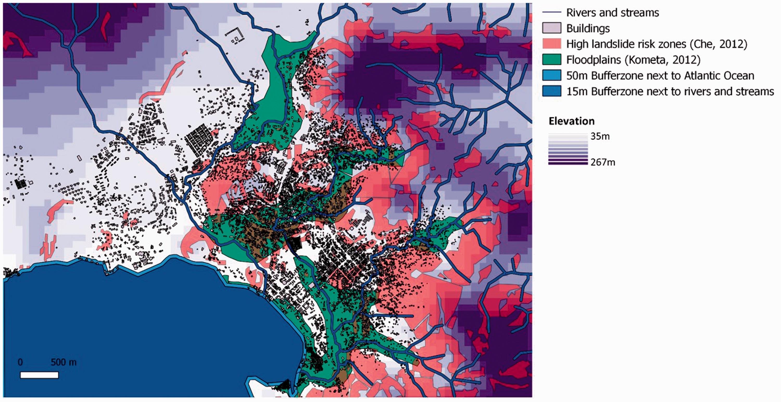
Buildings (OpenStreetMap Foundation, 2016) and high risk zones in Limbe city, including areas with high landslide susceptibility (Che et al., 2012a), floodplains (Kometa, 2012), 50 m buffer zone next to the Atlantic Ocean and 15 m bufferzone next to rivers and streams (Republic of Cameroon, 2004).
Noteworthy is the low risk perception of ‘newcomers’ that settle in risk zones. Migrants from inside Cameroon and other nearby African countries settling in are often not aware of the past disastrous events nor the hazardous nature of the sites. For example, many migrants come from the North-West region in Cameroon and previously lived on steep slopes that are less landslide-prone due to different lithologies, as reported by some interviewees. Consequently, many newcomers do not perceive their housing locations as risky nor understand why the government would restrict any settlement (Njome et al., 2010). Such risk zones are often ideally located for their livelihood (e.g. proximity to coastline for fishers and to industries for daily labourers). This situation is not exclusive for ‘newcomers’ but for most of Limbe’s inhabitants (e.g. Brewer, 2013; Fombe and Molombe, 2015).
Increased vulnerability
Besides the increased exposure to natural hazards, the risk zonation policy also leads to an increased vulnerability of people living in risk zones in various ways. First, this policy leads to settlements in areas with more substandard houses and less public services. As development is officially forbidden in these zones, most of these areas offer poor facilities. Services in these areas are then typically provided by the communities themselves and often face service congestion (Fombe and Molombe, 2015). Based on our survey, we observe that people living in quarters with high risk zones generally have a lower perceived evaluation of the quality of water supply, road network, waste disposal and sanitation, as well as street lights (Table 4). An NGO representative indicated, for example, that ‘Because the roads are not good on hillslopes, waste is not collected there, but people have to bring it down’ (Interviewee A, Personal interview). These settlements also face the worst perceived evaluations of toilet facilities, electricity supplies and security. Building permits are not needed for semi-permanent houses. Given the fact that land and rent are generally cheaper in risk zones (Fombe and Molombe, 2015), the alternative for poor people is to settle illegally in risk zones by constructing semi-permanent houses. Nonetheless, permanent houses, including two-storey buildings, have also been observed in these areas.
Perceived evaluation of quarter facilities provided by the government for each quarter type in Limbe, based on the household survey performed by the second author of this article. For the perceived evaluation of facilities, the percentage (and number) of respondents are shown that perceived the concerning facility as ‘good’.
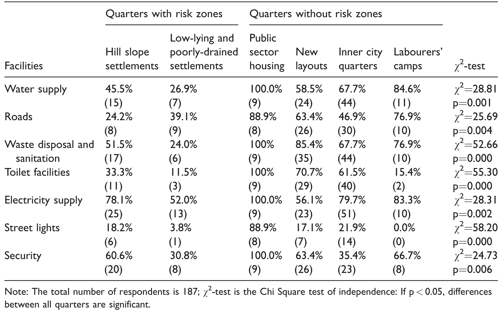
Note: The total number of respondents is 187; χ2-test is the Chi Square test of independence: If p < 0.05, differences between all quarters are significant.
Second, the policy prevents people from obtaining a land title or building permit, making them less secure in terms of jurisdiction and finances. An important consequence of not having a land title is the impossibility to request a loan from the bank. This is, according to an employee of the MINHDU, the prime objective to apply for a land title. In terms of jurisdiction, some respondents of Unity Quarters suggested that in case of disputes among the inhabitants, this dispute will not be settled by the city council. A respondent of Mabeta New Layout defined a risk zone as ‘an area where nothing permanent could be done […] and at any time they could be asked to leave’ (Interviewee M, Personal interview), illustrating the general feeling of insecurity. On top of that, some respondents living in risk zones indicated that they feel stigmatised when their houses have been marked as risk zone.
Conclusions
Drawing upon discourse and political theory, we conclude that authorities from the national to the local levels use a post-political discourse to promote and implement DRR in Limbe city, e.g. through risk zonation policy. We argue that risk zonation can lead to risk accumulation (i.e. increased exposure and vulnerability) instead of risk reduction if a post-political discourse for DRR is used. This was observed in Limbe city which is affected by ad hoc risk assessment and poor enforcement of the current risk zonation policy (Figure 4). Disaster risk accumulation then reinforces the need for more risk assessments and the current use of an authoritarian science regime and post-political discourse by authorities, through the used extraversion strategies, i.e. the rent-seeking behaviour of authorities.

Conceptual model representing how socio-political drivers shape how risk assessment is produced, circulated and applied through risk zonation policy, including its consequences for disaster risk.
Based on the Limbe case study, it is possible to provide insights on DRR for other Cameroonian and global South cities. Different academic studies have shown how several Cameroonian cities face similar problems of increased disaster risk in hazardous urban areas due to poor enforcement of the law (Bang, 2014; Fombe and Molombe, 2015; Tiafack et al., 2014). In general, studies have shown similar problems of so-called uncontrolled settlement in other rapidly growing cities in the global South (e.g. Dodman et al., 2017; Wisner et al., 2015). We might therefore argue that, based on this Limbe case, risk zonation offers an easy way for politicians to simultaneously justify and reproduce unequal urban development as well as avert responsibility of reducing disaster risk through a post-political discourse.
The main conclusion of this paper is that risk zonation policy is an often recommended DRR strategy both globally and locally due to two reasons. First, risk zonation policy is a highly effective strategy in reducing disaster risk when looking only at the bio-physical aspects and neglecting the socio-political aspects of disasters (e.g. Wamsler, 2006). Indeed, totally preventing exposure of humans and human infrastructures to natural hazards means no risk of disasters. However, in reality, many hazardous locations are currently inhabited and relocating these people is highly contested (e.g. Manyena et al., 2013). The emphasis on the efficacy from a bio-physical perspective, leading to the recommendation of risk zonation policy, follows the resurfacing technocratic logics promoted by international and national DRR communities. Second, risk zonation policy is a beneficial strategy for (semi)-authoritarian regimes. Risk zonation policy indeed gives the impression that governments concentrate on the protection of individuals from ‘sufferings’, but in practice, its post-political discourse to avoid blame, in the case of Limbe, has led to disaster risk accumulation instead of reduction. Pelling (2001) argues that a politically conservative approach to DRR, which focuses on techno-managerial solutions like risk zonation, is attractive to governments and aid donors because it does not oppose the political status quo. Furthermore, Hood (2002) suggests that the blame-shifting imperative may become more central to politics in general, as societies are increasingly becoming informed on and warned for potential risks. The point we want to stress is that this dominant post-political discourse in international treaties is attractive to sub-Saharan African (semi-)authoritarian regimes, as this discourse can easily be used to serve their rent-seeking interests while also pleasing donors. In other words, the resurfacing post-political discourse in disaster research and practice is used as an extraversion strategy by (semi-)authoritarian regimes.
Although our assessment of the risk zonation policy is rather pessimistic for the Limbe case, we do acknowledge the usefulness of this policy to reduce disaster risk. Risk zonation has been shown to be a successful policy in reducing the exposure of population in high hazard areas in some countries (e.g. Mannakkara and Wilkinson, 2013; Randolph, 2004). We consider that this could also be possible for our case study of Limbe city if certain conditions are fulfilled. Among these conditions we highlight the need for a transparent definition and application of these zones, together with the development of alternative settlement plans and infrastructure that take into consideration the vulnerability and needs of the population currently living in these high risk zones. Additional research is however needed to investigate socio-political drivers and blockages for effective DRR through risk zonation policy in other settings. Another, more radical, approach to make DRR more effective is the development of alternative policies that are based on more democratic, equitable and participatory decision-making, which acknowledges the different perceptions and needs of policy makers and scientists, on the one hand, and communities-at-risk, on the other (e.g. Broto et al., 2015). Cannon (2008) argues that DRR cannot be effective unless it takes people’s concerns about their everyday livelihood into account. In other words, DRR should reflect the priorities of those exposed to the risks (Nathan, 2008).
Footnotes
Declaration of conflicting interests
The author(s) declared no potential conflicts of interest with respect to the research, authorship, and/or publication of this article.
Funding
The author(s) received no financial support for the research, authorship, and/or publication of this article.