



Abstract
One of the challenges in creating plans for sustainable urban futures is the ability to work across government agencies and to break down traditional barriers to truly collaborative planning. Typically, metropolitan planning has been carried out by different agencies that are separate in their mandate and planning strategies. This siloed approach to city planning means there are problems in the coordination and sequencing of critical projects. To address this problem, we investigate the use of the Steinitz geodesign framework and the GeodesignHub.com software for supporting collaborative and integrated negotiation-based geodesign. We hypothesised that by using the geodesign framework we can involve key government agencies and begin to break down the barriers between these agencies to create a single integrated strategic plan for the city. In this research we focus on South East Sydney, discussing the process in designing and implementing the geodesign framework with real world actors spanning several government agencies, municipalities, industry and academia for this study area. This being the first application of geodesign in the Australian context, we draw on feedback from participants on the strengths and weaknesses of the framework.
Keywords
Introduction
Metropolitan Sydney and the potential of geodesign
One of the major challenges in strategic and metropolitan planning is the ability to work across government agencies and to break down institutional barriers to achieve coherent collaborative outcomes. Within Sydney and many other cities around the world, planning conventionally occurs according to a series of long-term plans created by different government agencies. A metropolitan area will have separate land use, transport and infrastructure plans focused on the delivery of the single objective for which they are set up. These plans may cross reference each other but often are in conflict. Typically, they are implemented through separate agencies, planning strategies and funding mechanisms. For example, in Sydney, public transport, roads, ecologically protected areas and housing are all the concerns of separate agencies. This siloed approach to city planning leads to problems coordinating and sequencing critical projects. For example, housing developments may be built 10 years before supporting transport infrastructure (such as trains) and social institutions (such as schools) are established. These problems are made more complex through fragmented planning structures and disagreement between different levels of government.
Within metropolitan planning, optimising one set of objectives for a given system such as transport can impact negatively on another system, such as housing or ecological performance (Gleeson, 2012). This is a well-known characteristic of planning in Sydney and a source of frequent political conflict. To address this problem, this research investigates the use of a framework for applying a collaborative and negotiation-based geodesign approach, in this case used to facilitate collaboration between stakeholders in their effort to solve a shared spatial problem. The framework requires that stakeholders come together and interact, leveraging their collective knowledge. This interaction is facilitated to explicate the system complexities of the study area, create design proposals and explore their system impacts (Leferink et al., 2016; Steinitz, 2012). We hypothesise that by adapting the (a) Steinitz geodesign framework and (b) free-to-use GeodesignHub.com software (Ervin, 2016) in a workshop format we can involve key government agencies and promote collaborative, integrated strategic planning within Metropolitan Sydney and other cities. This is the first time this planning support system (PSS) has been used in Australia. A pilot project in a district in South East Sydney (see Figure 2) is used to evaluate the geodesign approach.
The paper covers three main areas. First, the methodological approach is outlined exploring its suitability for addressing the limitations in current planning practice in Sydney. Second, the workshop process in designing and implementing the geodesign framework is described with attention to the workflow and characteristic participant interactions. Finally, the paper discusses the strengths and weaknesses of geodesign with regard to the outcomes of the workshop.
The geodesign methodological approach
The paradox of institution-based optimisation
The complexity of metropolitan planning has conventionally been tackled through specialised agencies responsible for addressing a limited set of objectives. The concept of best practice among agencies is based on the idea of delivering a particular outcome or product and achieving an ‘optimal state’. Urban agencies adopt narrow approaches to the delivery of urban services and products according to the culture of their organisation and to fulfil their specific mandate.
However, the result of many urban agencies optimising outcomes for a narrow set of objectives makes an integrated and meaningful outcome more difficult. Lee (1973) in his paper on large-scale urban modelling identified another issue of optimisation in that it tends towards ‘black box’ solutions, as purely mathematical approaches are applied to solving cities. At a more pragmatic level of city planning and design, negative outcomes also emerge through unintended cross system impacts. For example, an agency specialising in the delivery of roads may disregard other urban values and services outside their scope and unintentionally damage those alternative systems (Murray and Frijters, 2016). This complexity is exacerbated by the increasing privatisation of public agencies, the growing popularity of private–public partnerships and the deregulation of urban services that favour competitive economic development (Gleeson and Low, 2000).
City and metropolitan planning are wicked problems with characteristics of inherent uncertainty, complexity and cross system impacts that present a changing and evolving set of problems (Brown et al., 2010) and resist resolution through linear silo-based approaches (Hayek et al., 2016; Steiner and Shearer, 2016). Silo-based optimisation in the urban context has also had unforeseen negative consequences in liveability and environmental quality (Eraydin, 2013: 17), while also limiting the efficiencies and effectiveness of separate organisations as they compete for resources.
Sustainable and resilient urban development has emerged as theoretical and practical approaches, emphasising systems thinking and network-based governance structures over linear approaches. Despite the long emergence of these movements and their dominance in agencies such as the UN through their sustainable development goals, the managerial culture of local urban agencies in cities globally, including Sydney, has not fundamentally been altered. One approach to better adapt planning to the realities of urban complexity is through collaborative urban planning and tools to address spatial and political complexity (Hayek et al., 2016). Geodesign is one such systems approach (Steiner and Shearer, 2016; Steinitz, 2016), which is essentially the coming together of geography and design, assisted with some data-driven technology support.
Evolvement of digital tools in addressing spatial complexity
Digital tools have increased in capability as response to the need to better evaluate and address urban complexity, beginning to address Lee’s (1973) critique of ‘black box’ solutions. Early techniques of overlaying maps to inform design have been enhanced with the emergence of geographical information systems (GIS) and the need for spatial analysis, which has now culminated into the availability of a range of GIS-based, participatory, collaborative tools (Batty, 2013; Tulloch, 2016). This, in addition to the late-1900s uptake of scenario-planning, the process of outlining possible future outcomes and monitoring their consequences, allowed for the development of digital tools that assess multi-criteria scenarios (Lee, 2016).
Several digital tools came into use such as CommunityViz (Placeways, 2010), INDEX (Allen, 2001), ENVISION (Glackin, 2013), What If ? (Pettit et al., 2013, 2015), UrbanFootprint (Schmiedcke, 2016), UrbanSim (Waddell, 2002) and the Cube suite of modelling tools (Clay et al., 2012). In the context of Australia, these digital planning tools have been discussed by Pettit et al. (2018). Many are GIS based and create suitability analyses based on future land use and transportation demand (Lee, 2016). These tools, called PSSs, can predict impacts of different planning scenarios and in addition, visualise them through, for instance, suitability maps (Klosterman, 1997).
Campagna (2016: 119) refers to the ‘first generation of PSS’ as commercial, open-source, method-oriented, integrated systems that support planners. Their application is growing, aided through research and case studies (Russo et al., 2018; Sinnott et al., 2014; Spatial Decision Support Consortium, 2017) in addition to their open-source availability, yet they are still underutilised – partially due to a lack of awareness of their availability and capability (Geertman, 2017; Vonk et al., 2005). A framework for deployment of GIS-based tools, such as PSS, for collaborative decision-making in planning could assist in their uptake.
Geodesign framework and its potential to unify PSS
Geodesign is a framework for collaborative decision-making developed by Steinitz (1990). It has emerged partially due to a need ‘to better accommodate landscape architects, urban and regional planners and architects with geospatial technologies’ (Wilson, 2015: 228). Geodesign seeks to merge spatial analysis and the capabilities of land-use transportation modelling (Batty, 2013). It also mergers designers’ primary objective to present new options with scientists’ primary objective to understand how something came to be (Foster, 2016) by combining, adapting and using GIS tools to bring science and design together, developing solutions to urban problems (Batty, 2013).
The practice of scenario-planning and evaluation of changes in the built environment, transformed by computational capability, has contributed to the growth of geodesign (Ervin, 2011) as well as a growing interest in how it can inform land-use decisions based on environmental knowledge (Campagna, 2016). It is the ‘latest evolution of GIS in environmental design’ (Li and Milburn, 2016: 5). Perkl (2016: 46) summarises several definitions of geodesign, arriving at the conclusion that ‘geodesign is an emerging science and art in which the analytical rigor and methodological strategies of planning are being fused with the forward thinking, creativity and graphic capabilities of landscape design’.
The geodesign framework has the potential to apply PSS very specifically to a local context and train stakeholders in their use, through workshops. In this way, geodesign can become a unifying framework under which the range of PSS tools can be united. This can enable not only the informed evaluation of future scenarios but simultaneously the design of processes to facilitate the evaluation (Kong and Sui, 2016) – processes that involve multi-stakeholder collaboration.
The challenge of collaborative planning and political negotiation
Collaborative urban planning offers an inclusive approach to shaping geographic space and is well suited to addressing pressing urban and environmental challenges (Healey, 2007). Contemporary society is beset with a range of difficult problems that present a dynamic changing landscape of reduced predictability through phenomena such as climate change, migration and political and economic instability – necessitating a systems-based approach that has been influenced by ecological theory and sustainability.
Emerging interdisciplinary approaches to socio-ecological systems offer a theoretical model for planners and urbanists to use in addressing the complexity of cities (Wilkinson, 2012: 149). Collaborative planning is well suited to the rapidly changing landscape of the creative economy, digital disruption and innovation ecosystems which rely on the cross-fertilisation of ideas and knowledge spillovers that come from free-flowing interactions within a creative milieu. Such approaches are also cognisant of the dismantling of old distinctions between the state and market and the entrepreneurial mindset that pervades government today.
Despite the above arguments in favour of collaborative planning, the approach presents various difficulties for those wishing to adopt it. Collaborative planning challenges the preconception that there is an ultimate truth ‘out there’. It works with the assumption that everything is socially constructed and seeks to open-up knowledge silos and form creative points of intersection for linear narratives. In this way it is process orientated (Campagna, 2016) and so involves a method which is not necessarily aligned to a certain outcome. This element of political risk can encourage fear in governments which require certain outcomes to follow up to political promises and proposals.
While governments are wont to extoll the virtues of collaborative planning and participatory practice these are perceived to be at odds with rapid decision-making and greater decisiveness, speed and outcome-based planning. This tension between the conventional linear modes of planning and network-based collaborative planning is a conundrum for government and urban agencies. To address this political complexity, system experts and stakeholders need to engage in a collaborative design and decision-making process – a learning process whereby all participants can iteratively explore opportunities to improve their initial ideas as they consider new information or mutual political interests regarding component policies and projects (Mayer et al., 2005; Van Bueren, 2001).
This process cannot be about a narrow focus on consensus in such a pluralistic world. Rather the process requires embedding planning platforms that support ‘difference and disagreement in respectful acknowledgement of “the other”’ (Brand and Gaffikin, 2007: 308). To build such a platform, principles of engagement must favour civic empowerment and make space for considered and systematic negotiation. Such a platform allows diverse actors to come together and vigorously negotiate ideas, changing both the ideas and the actors. Brand and Gaffikin (2007: 308) put it aptly when they say that such a system must provide capacity to negotiate beyond petty ‘interest-based bargaining and horse-trading’ to create genuine opportunities for mutual growth and broader civic outcomes.
The role of geodesign in collaborative stakeholder negotiation
Geodesign’s relevance to the above described acts of stakeholder negotiation lies in its capacity to support interdisciplinary collaborative planning which is driven by the best available data and evidenced to empower participants to create a longer term integrated spatial plans which can underpin the concept of sustainable urban development (Campagna, 2016; Perkl, 2016). It also acknowledges the limitations of individuals and individual urban agencies by creating space for negotiation and collaboration (Muller and Flohr, 2016). Scenario-planning through geodesign differs from other methods in that it is more complex, involving a greater range of interdisciplinary interactions, and that it involves the community through collaborative processes which allow human values to be infused into design and planning (Lee, 2016).
As a method, geodesign tightly couples the creation of design proposals with impact simulations informed by geographic contexts. It does this within a framework informed by systems thinking and is usually empowered by digital tools (Steinitz, 2012). It is most frequently delivered through an intensive workshop that brings different stakeholder groups together to consider a pressing problem (Huang and Zhou, 2016; Janssen and Dias, 2017; Slotterback et al., 2016).
Steinitz (2012) frames the geodesign process in terms of six main questions and corresponding models: (1) how should the study area be described? answered by
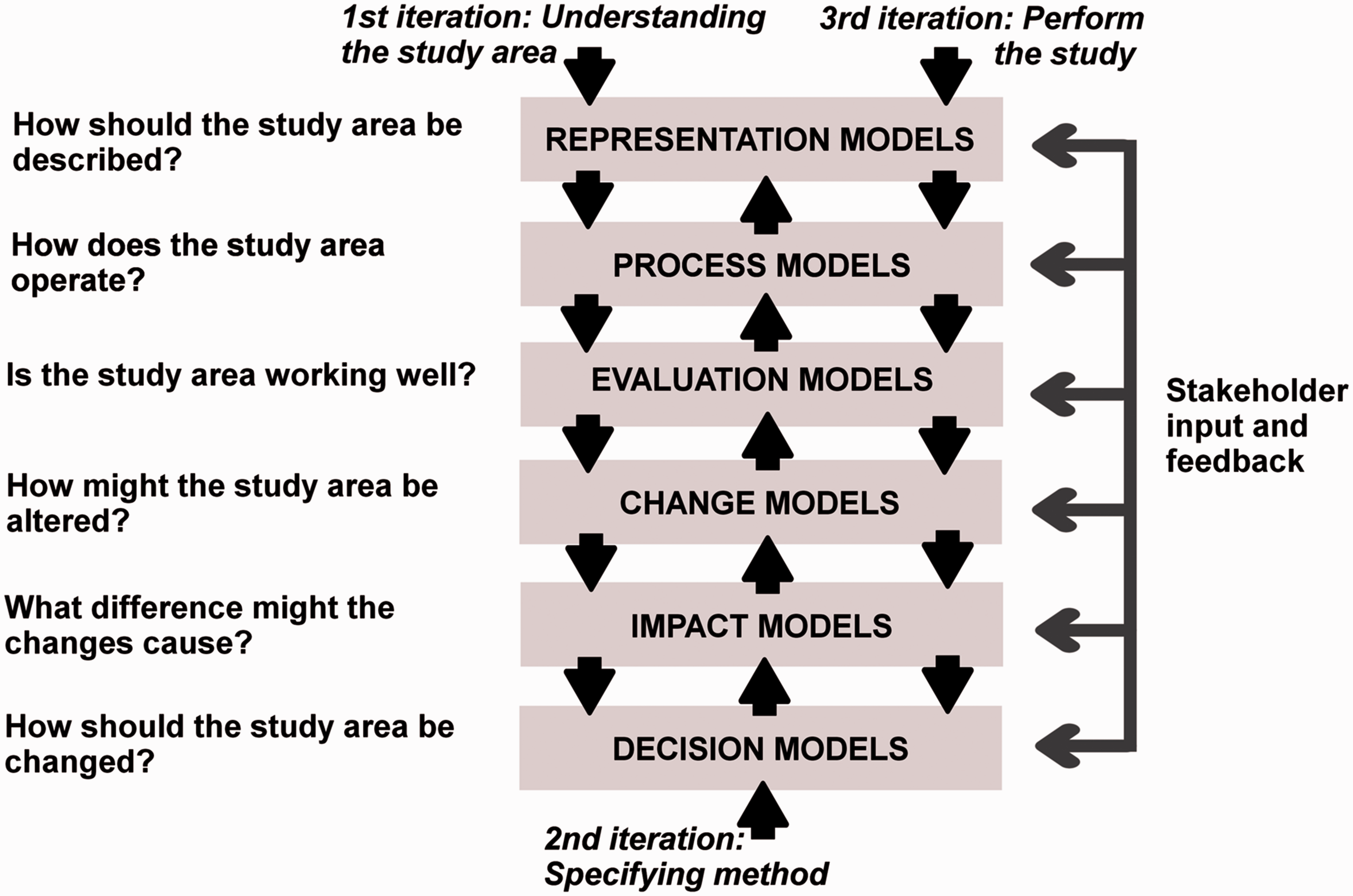
The geodesign process with six questions and six corresponding models. These were facilitated through the GeodesignHub software. Adapted from Steinitz (2012).
Although the geodesign framework appears excessively linear in Figure 1 for purposes of communication, the framework is not normally linear in its application. In this instance, the first three models were primarily geographical and negotiated simultaneously, described in this paper as the ‘pre-workshop phase’. The last three models were predominantly design based and enacted over an intensive two-day period described in this paper as the ‘workshop phase’. This represented one geodesign iteration. Usually at least three geodesign iterations are enacted to ensure all aspects within the geodesign framework are addressed.
The dominant mode of technical communication within these workshops is the ‘diagram’, a graphical gesture that communicates either a physical project or a planning policy. Geodesign uses diagrams and maps to describe the physical and political elements of the study area (e.g. topography, district boundaries, land zoning, residential and commercial areas, protected lands, etc.), and to allow stakeholders to convey proposed urban and environmental intervention plans. Diagrams and maps serve as the ‘visual language’ facilitating communication between participants.
In this workshop the maps and diagrams produced as part of the pre-workshop and workshop phases were input and manipulated in GeodesignHub, an online-based tool developed by Hrishi Ballal in cooperation with Carl Steinitz and Stephen Ervin to facilitate geodesign workshops. The tool can record the evolution of overall conceptual designs, detailing where, when and which project diagrams have been added and removed over the course of the negotiation process towards agreement on a preferred design outcome.
The Sydney Workshop
Sources of political and planning complexity in Sydney
Political complexity arises from the diverse interests held by stakeholders. Their political, public and financial support is needed in order for future change to progress, and progress is inevitably shaped by how well these stakeholders can negotiate their competing interests in the designed plan and arrive at a satisfactory level of consensus (Mayer et al., 2005).
In Sydney, there have been several major trends that have increased complexity. These trends include the promotion of the entrepreneurial or competitive city, the retreat from comprehensive strategic planning by government in favour of public–private partnerships, outsourcing of planning and design functions to the private sector and finally a tendency for institutional fragmentation. Rather than reducing risk and producing a simpler smaller government, such initiatives have more often redistributed risk and increased complexity (Ruming, 2010) and have also tended to reduce collaborative capacity.
The sources of political complexity within urban governance and planning in Sydney and Australia are well acknowledged (Stilwell and Troy, 2000), particularly involving Australia’s three-tiered system of government. Urban development operates through a sustained tension between federal, state and local levels of government. This makes funding and implementation of urban visions difficult, further complicated by the complex mosaic of local governments who are not mentioned in the constitution but are arguably positioned to be the most sensitive and attuned to issues of place. Local governments typically lack the large resources of state governments. Subsequently, local governments vary greatly in capacity for planning expertise. While some are progressive and more informed than the state government on urban challenges, others are a source of inefficiency and inertia. Further, none of these organisations are purely focused on metropolitan- or district-based urban planning and design.
This variety and tension between government institutions and levels is a source of democratic richness but also inefficiency and lack of an urban focus. In a 2015 media release then-incumbent New South Wales (NSW) Minister of Planning Rob Stokes expressed that ‘for too long Sydney’s urban planning has operated in silos of councils and government departments, without effective joined-up coordination for the infrastructure [the] city and suburbs need’ (Greater Sydney Commission, 2015). In response to this, the Greater Sydney Commission was established to coordinate the planning for six new districts which would be formed through the amalgamation of various local councils. The commission was to be responsible for delivery plans for each of Sydney’s six districts.
This vignette of Sydney’s political complexity highlights the need for a cross cutting mechanism independent of political structures that can rapidly facilitate high quality, transparent decisions amid complexity. As Healey (2007) emphasises the development of urban areas, understood in socio-economic and environmental terms, cannot be ‘planned’ by government action in a linear way, from intention to plan, to action, to outcome as planned…socio-economic and environmental activities make use of the physical fabric of urban areas in all kinds of ways that are often difficult to imagine in advance, let alone predict. (3)
Geodesign was therefore envisaged as a mechanism to bring the various stakeholders together to work effectively in a collaborative way, in the milieu of political and environmental complexity.
It was decided to carry out the first application of geodesign in Australia in the South East Sydney Catchment (see Figure 2) because it expressed the complexity of Sydney’s planning system and environmental context well. Covering approximately 5500 hectares, the study area intersects the jurisdictions of three local government areas: Randwick City, City of Botany Bay and City of Sydney. It covered several ‘state significant areas’ which are under the jurisdiction of the state government. These include major institutional, infrastructural and transport and tourist landscapes such as Port Botany, the University of New South Wales, Prince of Wales Hospital and several of Sydney’s famous tourist beaches. It also contains the terminal route of the new light rail project (under construction at time of writing) and several urban renewal precincts – such areas of rapid and significant current change.

Case study; South East Sydney Catchment; Geodesign workshop Sydney 2016.
The pre-workshop phase: Establishing frameworks for negotiation
Thirty participants comprising three local councils, a water utility agency, an education agency, a transport agency, two central planning agencies, two land development corporations, two universities and two private sector consultancy firms were invited to the geodesign workshop.
A series of assumptions were developed based on initial conversations with invited stakeholders and using the population projections for 2050 developed from Australian Bureau of Statistics (ABS) (ABS, 2013) and .idcommunity (2016) population forecasts (https://forecast.id.com.au/) for each of the three Local Government Areas comprising the study area. These formed the basis for the change models within the workshop. The assumptions included over 75% population increase within the study area and a change in demographics with increased diversity, demand for 175,000 additional dwellings, flood risk due to sea level rise, freight industry moving out due to the new Western Sydney Airport and growth of high value industries driven by the expansion of the university and hospital precinct.
These broad future-based assumptions formed the background for the project change models that all workshop participants would need to consider in designing their development proposals for the study area.
The local planning knowledge held by the geodesign pre-workshop team in collaboration with stakeholders allowed a considered development of both decision and evaluation models to establish the spatial frameworks in which the workshop would take place. Intensive discussions centred around the systems to be used in the evaluation model. The systems used by Nyerges et al. (2016) served as an initial reference point for the research team. Of these systems, those that were thought to be crucial to the Sydney study area were selected to be utilised in the preparation of the evaluation models. The nine systems used during the workshop included (1) medium density housing, (2) high density housing, (3) public transportation, (4) active transportation, (5) green infrastructure, (6) blue infrastructure, (7) education, (8) health, (9) tourism. Specific targets were developed for each system in line with the broad-based assumptions above mentioned. For example, an equivalent of 900 hectares of medium density housing and 300 hectares of high density housing was set as targets.
Evaluation maps were developed to correspond to the chosen systems and used by workshop participants to guide feasibility assessment for development. Feasibility was visualised with a selected colour scheme, and category definitions were informed by local environmental plans, land zoning, planning rules of thumb and consultations with experts of each system (see Figure 3).

(Left) Feasibility category definitions for an evaluation model, (right) Evaluation map visualising the evaluation model. Evaluation maps were created from GIS data sourced from Transport NSW, ABS Census data 2011, NSW Land and Property Information, NSW Open Data, Department of Education, Bicycle Network, and Randwick City Council. The maps were put together using ArcGIS and QGIS packages, before they were uploaded onto GeodesignHub.
The research team met with selected stakeholders and system experts including planners from Randwick and Botany Bay Council, Sydney Water, Transport NSW and Education NSW to seek feedback on the drafted evaluation maps. The consulted experts volunteered information about how their system worked in the context of the study area and offered to provide additional data for the evaluation maps.
The workshop phase: Negotiation in action
The workshop was held over the course of two days with 30 participants intensively collaborating and negotiating within one wirelessly networked room set up with laptops, monitors, whiteboards and large format sketchpads. The participants were first introduced to the study area, the objective of the workshop and the year 2050 projections that they would need to consider in their design. They then underwent a quick tutorial of GeodesignHub by Hrishi Ballal, with each participant working on a laptop and a team coordinator linking their laptop to an easily viewable monitor to integrate the work of the team in a unified design for the group to discuss.
The two-day workshop took place within four major stages summarised in the following subsections:
Morning Day 1
In the initial stage, participants were divided according to their area of expertise, forming nine groups, each corresponding to one of the systems. These nine groups were asked to draw diagrams representing projects or policies they would propose in the interest of improving their own system. For example, the Tourism team drew projects adjacent to the beaches to improve tourism facilities nearby and access to the beaches. The 30 workshop participants generated over 100 diagrams.
Afternoon Day 1
Participants were then reorganised into stakeholder groups of around six members, intentionally integrating expertise from various knowledge domains.
Each group was assigned to one of six primary scenarios to pursue in their design for the study area (Environmental Sustainability and Resilience, Housing Development, University and Hospital employment cluster expansion, Efficient public service access, Tourism and Recreation growth, Compact City). The scenarios had been developed, prior to the workshop, with the Greater Sydney Commission (2016) to correspond to objectives of A Productive Sydney, A Liveable Sydney, A Sustainable Sydney.
Each group developed an initial design, incorporating the most appropriate diagrams from the morning workshop, and then evaluated the cross system impacts and costs to produce a more optimised second design.
Morning Day 2
The stakeholder groups presented their second version to the other teams, who rated the designs according to how well each responded to stakeholder interests. Based on commonalities in their designs, the groups were encouraged to collaborate with other teams and develop a third design.
Afternoon Day 2
The afternoon of Day 2 involved intense negotiations, supported by GeodesignHub tools including the ability to access cross system impacts and analyse contrasting designs on the same screen simultaneously. Presentations by the six teams were followed by a simple rating of each team’s design according to its quality and compatibility to the others. The resulting ratings were then entered into a sociogram to organise negotiation between the most compatible teams to generate consensus. By consolidating visions and teams, a fourth design was then presented to the group, which was refined and negotiated into a final design proposal for future development of the study area (see Figure 4).
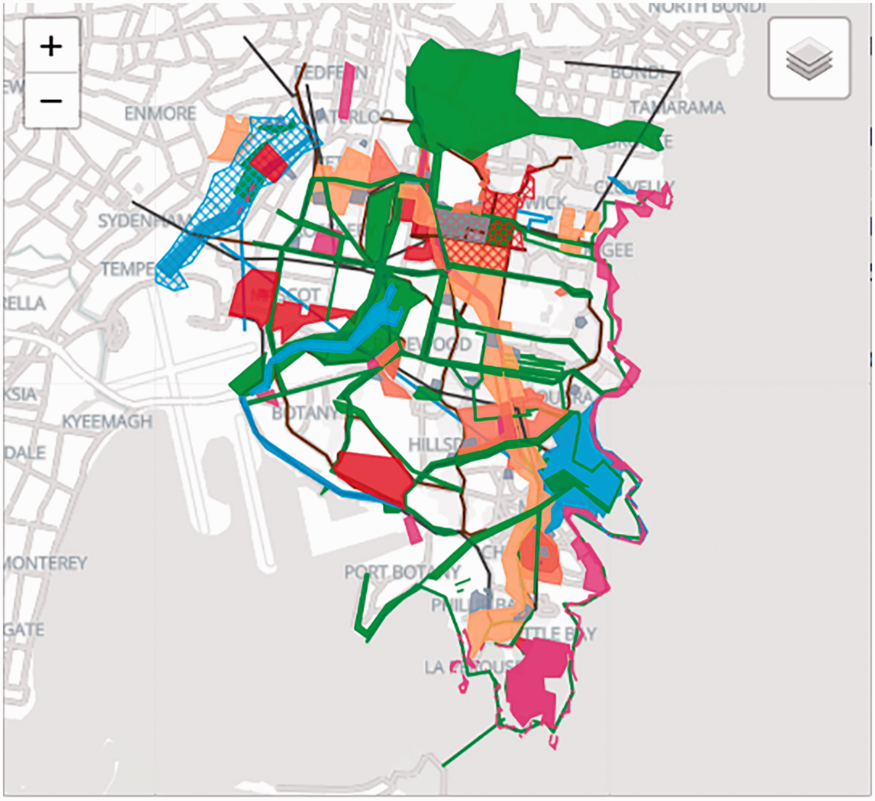
Final South East Sydney 2050 design proposal after final negotiation round. Screen capture from GeodesignHub project.
Discussion: ‘Support’ in light of PSS for collaborative decision-making
Collaborative negotiation dynamics and collaborative digital tools
Collaborative decision-making through geodesign involves a process of coordinated negotiation. The geodesign process provided a clear framework for organising the ordered and progressive sequence of decisions in a way which magnified collaborative possibilities and at the same time provided precise points for negotiation and moving forward in a coherent way. This balance between linear progression and the complexity of spontaneous non-linear networking was evident throughout the workshop.
First, the simple act of placing stakeholders in the same room at the same time may seem simple but was a highly complex task in itself and highly significant. The co-location of participants from very different agencies and from different parts of Sydney contributed to the success of the workshop and the quality of the outcome. As strategic planning is a highly political process, time to organise real-world people to attend a two-day workshop is difficult and may not be possible in all situations. Alternatives might be to break the workshop down into smaller components, but this may also reduce its effectiveness in integrated decision-making.
The intensity and layering of both face-to-face and digital modes of interaction were built progressively throughout the workshop. Initially, interactions were more fragmented both by design of the workshop and through the natural distance between new acquaintances. Intensity and interaction increased as the workshop progressed, building from the first to the fourth and final stage of the workshop.
The roles of individuals within the workshop also changed over the two days from more domain-based systems thinking to interdisciplinary negotiators. This management of knowledge allowed the shifting of roles from being curators to communicators of knowledge. These strengths of geodesign could help counter the fragmentation and specialisation of knowledge within separate urban agencies. It is important to note that GeodesignHub’s user interface and the expert guidance by the workshop facilitators made the digital and design aspects of the workshop suitable for non-technical users.
Reflecting on workshop results
It was evident from the workshop that the geodesign method has great potential in facilitating and structuring creative interactions both through face-to-face and online digital modes, and GeodesignHub’s analytic capabilities can capture the detailed decision-making for the duration of the workshop.
Interestingly, the workshop participants produced a total of 480 diagrams of policies and projects. Yet none of the initial 100± diagrams were in the final design in their original form. All the final six teams’ designs and the final negotiated design included policies and projects that had been edited or replaced, which is evidence of learning through collaborative negotiation. The capacity of GeodesignHub to provide important information on performance of the participants and collaborative teams in a workshop therefore supports changes to negotiation processes and contributes to ongoing improvement of collaborative and consensus building dynamics, which are often thought of as a ‘black box’ within the highly politicised world of strategic planning and design. Roderick Simpson, Environment Commissioner for the Greater Sydney Commission and workshop participant offered an interesting take on the potential for such analytic capabilities: The selection process and negotiation in the geodesign process could be considered a form of emergence, particularly if emergence is seen to be a pattern or an idea that gains prominence. This is through the negotiation process and consensus – which is where the geodesign process adds significant value. Do you agree with the final proposal? How well do you think your team’s interests were addressed or included in the final proposal? Did you find the geodesign process difficult or easy to follow? How successful was the geodesign approach in helping you understand a systems approach for planning?
For Question 1, 66% either ‘completely agreed’ or ‘agreed’ with the final proposal, yet for Question 2, 81% indicated that they thought their team’s interests were either ‘very well’ or ‘well’ addressed in the proposal. These results indicate participants considered the geodesign process inclusive of a range of views, even if the consensus with the final proposal was not as high.
With respect to Question 3, 71% found the geodesign process ‘easy’ or ‘somewhat easy’. This indicates a high degree of usability, differing from the un-facilitated PSS processes reported by Russo et al. (2018). The results in our study indicated the combination of human facilitation supported through data-driven technology created a much more user-friendly experience. Question 4 investigated if the participants found geodesign useful in understanding a ‘systems of systems’ approach. Ninety per cent of the participants found geodesign was either ‘very successful’ or ‘successful’ in doing so.
Further application of the geodesign framework in Australia
The geodesign process’s integration of different urban agencies with varying agendas informed the decision-making and negotiation process and encouraged debate. The workshop successfully demonstrated the potential of geodesign to break down knowledge silos from across government. One possible area of application is in the development of Smart City plans for various urban centres throughout Sydney and Australia, helping to envisage spatial impacts of the bewildering array of smart technologies.
As a PSS, geodesign has the capacity to involve community stakeholders in a greater capacity. The results from the participants highlighted that they founded the combination of a human-facilitated approach with technology user friendly and thus could be welcoming in a community engagement exercise. However, more research is needed in how this might change the dynamics, pace and staging of the workshop.
The communicative tools used in GeodesignHub could be adapted to assist with community and non-expert interactions (Talen, 2000). Specifically, future research is recommended to convincingly communicate 3D and experiential impacts of policies and projects in real time, potentially through the utility of touch table technology (Boulange et al., 2018; Pelzer et al., 2013).
Conclusion
This geodesign workshop was the first to be held in Australia. Geodesign is driven by a process and decision-making framework rather than a piece of software. Nevertheless, GeodesignHub, the digital platform used, provides powerful analytic capabilities and insights into the complex collaborative decision-making process. The study area, based in South East Sydney, comprised three local councils in an area experiencing rapid urban growth. The intensive two-day geodesign workshop was held in December 2016 to explore six alternative urban future scenarios projected forth to 2050; these were developed through successive iterations to reach a single agreed-upon design. It can be concluded that there was a high degree of consensus among participants because results were not endorsed by a central planning agency, and most participants were domain experts or from government agencies and brought a high degree of expertise and professionalism to the scenario-planning approach.
In this paper, we have outlined a geodesign approach which used the best available data and expertise and brought this together using a consensus building framework which can enable government silos to be broken down, providing a way to address the fragmentation and complexity of current planning environments. However, it should not only be seen as a way to address this deficit or problem but as an approach that can help shape concrete defensible visions for the distinctive variety of urban places which are driven through collaboration and consensus.
Footnotes
Declaration of conflicting interests
The author(s) declared no potential conflicts of interest with respect to the research, authorship, and/or publication of this article.
Funding
The author(s) disclosed receipt of the following financial support for the research, authorship and/or publication of this article: This research was funded by Sydney Water.