
Abstract
The conformance approach is frequently used to evaluate the effectiveness of spatial plans in containing urban sprawl. However, non-conformances are widely considered inevitable. Prior conformance-based evaluations fail to answer the essential question of whether plans influence non-conforming situations. To address this gap, we built a framework for conformance measurement to reveal how plans affect non-conforming urban development. The multi-indicator framework includes quantitative indicators, the spatial distribution relationship between new non-conforming urban land and zoning maps, and the location and original land use of new non-conforming urban land. When applied to a case study, this framework reveals that most new non-conforming urban land was adjacent to conforming urban land and located in zones without strict restrictions on urban development. Moreover, the type of land use that the zoning map aimed to conserve was rarely converted, suggesting attempts by decision-makers to control the severity of conflicts between non-conforming development and the zoning map. A logistic regression also evidences the significant influence of zoning on non-conforming urban development. These findings, in turn, verify the operability and theoretical value of the proposed framework.
Introduction
Spatial plans are widely used as a basic tool for urban growth management (Mathur, 2019), aiming to contain urban land development within designated areas or exclude it from certain districts (Chapin et al., 2008; Lewis et al., 2018). Accordingly, the effectiveness of spatial plans in governing urban expansion is usually evaluated using a conformance criterion (Alterman and Hill, 1978; Feitelson et al., 2017; Tian and Shen, 2011), which regards plans as blueprints and the non-conformance between outcomes and plans as planning failure (Faludi, 1989; Lyles et al., 2016; Talen, 1997). The conformance approach is considered objective and easy to operate, and can directly reflect the extent to which zoning maps have been implemented (Laurian et al., 2004; Shen et al., 2019). However, total consistency between actual land use and plans is almost impossible due to the bounded rationality of plans and future uncertainty. Evidence for non-conforming urban expansion has been found in the USA (Dempsey and Plantinga, 2013), Canada (Vyn, 2012), some European countries (Bakir et al., 2018; Siedentop et al., 2016), Israel (Alfasi et al., 2012), India (Chakraborti et al., 2018), Laos (Sharifi et al., 2014), and China (Shen et al., 2019; Tian and Shen, 2011). Some studies argue that non-conformance alone does not show that plans make no difference (Faludi, 1989; Shen et al., 2019); on this basis, the conformance approach fails to completely reveal the actual influence of plans (Feitelson et al., 2017; Lyles et al., 2016; Zhong et al., 2014). Therefore, the conformance criterion is considered to have an internal theoretical defect (Faludi, 1989; Oliveira and Pinho, 2010; Talen, 1997).
Due to its merits and the absence of a satisfying alternative approach, the conformance criterion is still most frequently applied in plan implementation evaluation (Laurian et al., 2004; Rudolf and Gradinaru, 2019; Tian and Shen, 2011). Yet few methodological attempts have been made to alleviate its defect by improving the conformance evaluation method. Evaluations have mainly been based on a spatial comparison between actual land use and zoning maps, resulting in a simple dualistic answer on whether urban land use is inside or outside the zoning. The role of plans in non-conforming situations remains beyond the scope of this conformance approach and challenging for other theories and methodologies on plan implementation evaluation (Feitelson et al., 2017; Oliveira and Pinho, 2010). Accordingly, this study builds a comprehensive framework for analyzing the non-conformance between urban expansion and zoning maps, aiming to alleviate the oversimplification and rigidity of the conformance criterion and to reveal the influence of plans on non-conforming urban development.
A framework for conformance evaluation
Quantitative indicators
Quantitative indicators are established to reflect the overall conformity rate between urban expansion and zoning maps and to reveal the direct driver of non-conformance, specifically whether the zone for the urban area (ZUA) is large enough to accommodate all the urban development. The indicators are as follows


In these equations, NULin, ULin-initial, NULout, and ULund refer to the acreages of new conforming urban land developed within the planning period, conforming urban land developed before the planning period, new non-conforming urban land (NNUL) developed within the planning period, and undeveloped land in the ZUA, respectively. The sum of NULin and NULout is the total new urban land created during the planning period, while that of NULin, ULin-initial, and ULund is the total scale of the ZUA. CON1 is the conforming rate of new urban land, CON2 is the saturating rate of the ZUA, and CON3 is the ZUA’s accommodating capacity for urban development. Zoning maps perform well in containing urban growth if CON1 approaches 1. Non-conforming urban development is probably due to the insufficient size of the ZUA, rather than any weakness in its binding force, when CON2 approaches 1 and CON3 is small. Moreover, it is necessary to review the rationality and effectiveness of zoning maps if both NULout and ULund are large.
Spatial distribution relationship
As displayed in Figure 1, the spatial distribution relationship between urban land parcels and the zoning map can be divided into four types: conformity, part-conformity, adjacent nonconformity, and dispersive nonconformity.
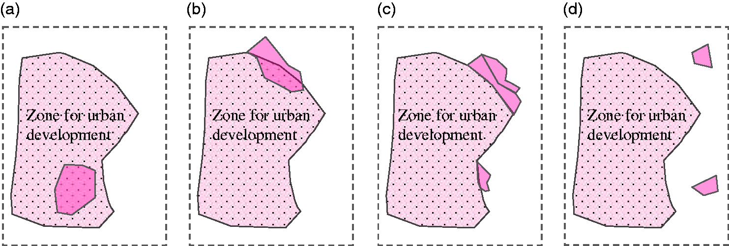
Degrees of spatial conformance. (a) Conformity, (b) part-conformity, (c) adjacent nonconformity, and (d) dispersive nonconformity.
Differentiating the degrees of spatial conformance contributes to discerning how zoning maps influence non-conforming urban development. In the conformity situation, zoning maps fully control urban development. In the part-conformity and adjacent nonconformity situations, non-conforming urban expansion may be driven by saturated development or the fragmentation of neighboring land inside the ZUA, which is necessary for generating an agglomeration economy and locating large-scale projects. In these cases, plans are not necessarily uninfluential. By contrast, in the dispersive nonconformity situation, zoning maps are manifestly less influential from the perspective of the spatial distribution relationship. Additionally, urban sprawl studies argue that scattered urban expansion is always associated with large-scale farmland conversion, severe pollution dispersion, heavy energy consumption, high cost of public infrastructure development, and inefficient land use (Andong and Sajor, 2017; Chen et al., 2017; Zhao and Zhang, 2018). Consequently, the dispersive nonconformity case may violate not only zoning maps but also the fundamental intention of spatial plans, such as smart and low-carbon growth.
The location and original land use of non-conforming urban land
Usually, spatial plans covering a whole administrative region include maps that delimit zones for different land uses with disparate regulations. Thus, gaps in degrees of restriction on urban development exist among zones. For example, mining land, rural construction land, and urban land are all subclasses of construction land in China, so converting land in zones for mining or rural construction into urban land conflicts less with the zoning maps in land use plans compared to developing land in the zones for farmland protection. Accordingly, if non-conforming urban land is mainly located in the zones without strict restrictions on urban development, then zoning maps are still influential, as shown in Figure 2.

Influence of zoning maps on the location and land conversion of non-conforming urban development.
Moreover, a certain zone generally contains a dominant type of land use and some other land use types. The aim of zoning lies in protecting the dominant type of land use or containing the expansion of that land use within the zone. For example, the ordinary farmland zone in Chinese land use plans aims to protect ordinary farmland (the dominant land use type) but may also include other land uses, such as a small amount of construction land, within the zone. These other land uses are allowed to be retained. It is obvious that, in the ordinary farmland zone, occupying farmland for urban development deviates more from the zoning map than occupying other land. Furthermore, converting farmland in farmland protection zones conflicts more with the zoning map than converting farmland outside such zones. Regarding construction land zones (e.g. the rural construction zone), occupying the dominant type of land use for urban development may not deviate materially from zoning maps, since their intention is to contain the expansion of these land uses, rather than to preserve them.
The study area and the zonings in its land use plan
The study area and the data
We apply the above framework to evaluate the influence of land use zoning in Baiyun’s Comprehensive Plan for Land Use (2006–2020) on non-conforming urban development. The land use plan data, including land use zoning and regulations on zoning, as well as the land use data of the base period (2005), were obtained from the database of Baiyun’s Comprehensive Plan for Land Use (2006–2020). The land use data of 2014 (since data from more recent years are not available, this study only evaluates the conformity between the new urban land increased during 2006–2014 and the zoning map) were from the annual land survey of Baiyun. In the following interpretation model for non-conforming urban development, the distance variables were also extracted from the database of the land survey. Statistics such as economic and demographic data were from the statistical yearbook of Guiyang. The data on land use plan and land survey, and the statistical yearbook were provided by the Guiyang Land and Resources Bureau. The land use data in the plan and that in the land survey did not classify the urban land, so the specific use of urban land could not be recognized. Information about the specific use of non-conforming urban land came from the author’s field study in October 2016. Elevation data were downloaded from the geospatial data sharing network platform (http://www.gscloud.cn/).
Baiyun, a county-level district in Guiyang (the capital of Guizhou Province, China), comprises five towns and covers an area of 26,952.4 hectares (Figure 3). It is one of the key development districts in Guiyang, as the location for the city’s provincial economic development zone and national high-tech industrial development zone. In the recent decade, it has seen more rapid economic growth and urbanization than the national average. Baiyun had a GDP of 15.1 billion yuan and a population of 273,500 in 2014, up 216.8 and 55.5%, respectively, compared with 2005. Driven by rapid economic and population growth, its urban land area increased to 3517.8 hectares in 2014, up 60.3% compared with that in 2005. Rapid urban development increased the difficulty of land use zoning to control the scale and spatial distribution of urban land.

Baiyun’s location and land use zoning.
The local land use zoning
Chinese land use plans feature two types of zoning designating urban development zones: construction land zoning and land use zoning. The former divides all the land into four zones according to the degrees of restriction on land development: the development permitted zone, development conditionally permitted zone, development restricted zone, and development forbidden zone. The latter delimits zones for different land uses (Figure 3). Within each zone, the dominant land use may be accompanied by other land uses. For example, the acreage of the prime farmland protection zone in Baiyun is 3426.8 hectares, of which farmland (the dominant land use) accounts for 86.4%. In the construction land zoning, land development is allowed only in development permitted and conditionally permitted zones. These two zones cover zones of construction land types in the land use zoning, such as ZUA, rural construction, and mining zones. Although no strict restriction was set on urban development in the rural construction and mining zones, the zoning map tends to contain urban expansion mainly in the ZUA. Compared with the development permitted and conditionally permitted zones in construction land zoning, ZUA in land use zoning can be used to more precisely discern NNUL. Therefore, we use land use zoning to evaluate conformance.
Table 1 presents the degrees of restriction on urban development in land use zoning. The ZUA is designated for urban development. Both rural construction land and mining land are subclasses of construction land, and urban development in the related zones is allowed if reasonable. In addition, suitable urban development in these zones is encouraged in China, since redeveloping rural construction land and abandoned mining land is considered conducive to improving land use efficiency and reducing farmland and ecological land conversion. No restriction on land use is set for the other land use zones. Land for scenic and recreation facilities is also a subclass of construction land, but the scenic and recreation zone is mainly designated for building such facilities, with restrictions imposed on the scale of urban development. In principle, urban development is not allowed in the ordinary farmland and woodland zones, while small-scale tourism development with limited side effects on the eco-environment may be allowed in the natural and cultural heritage reserve zone, provided that the natural and cultural landscape is well protected. Zoning regulations encourage (but do not force) local government to reduce construction land in these three zones. Finally, urban development is forbidden in the eco-environmental protection and prime farmland protection zones, where there is strong encouragement to reduce existing construction land.
Regulation of Baiyun’s land use zoning on urban land development.

ZUA: zone for the urban area.
Note: In the column Degrees of restriction, “−” represents that urban development is expected to be confined to the zone; “Slight” means that there is little restriction on urban development in the zone; from “+” to “+++”, the restriction on urban development strengthens successively.
Results
Spatial conformance between urban development and land use zoning
As shown in Table 2, new urban land that had developed by 2014 in Baiyun reached 1329.6 hectares, of which 493.4 hectares (37.1%) was NNUL. As 4736.1 hectares of land was undeveloped in the ZUA, CON3 reached 959.9%. As the area of undeveloped land in the ZUA was much larger than that of the NNUL, the ZUA was evidently large enough to accommodate all the urban land, including that which did not conform. Therefore, non-conforming urban development was not caused by the size of the ZUA. As Figure 4 shows, the NNUL had a wide spatial distribution in Baiyun.
The spatial conformity between urban land and zoning in Baiyun.

ZUA: zone for the urban area.

Spatial conformance between urban development and land use zoning.
Though CON1 reached 62.9%, the area of new urban land parcels located totally inside the ZUA was only 525.1 hectares, accounting for 39.5% of all the new urban land. However, of the 37.1% of new urban land outside the ZUA, only 35.0 hectares (2.6%) constituted dispersive nonconformity (where the total land parcel was outside and not adjacent to the ZUA), while 160.7 hectares (12.1%) constituted adjacent nonconformity. New urban land parcels that crossed the ZUA boundary accounted for 45.8% of the new urban land; these were mainly located in Yanshanhong and Maijia, with non-conformances driven by the full development or fragmentation of neighboring land inside the ZUA (Figure 4), thus contributing to the accommodation of large-scale investment projects or linear infrastructure projects and the improvement of the urban area’s overall connectivity.
The location and sources of non-conforming urban land
Figure 5 illustrates the location and original land use of NNUL in Baiyun. Of the total NNUL, 392.3 hectares (79.5%) was in the other land use, rural construction, mining, and scenic and recreation zones, where the degrees of restriction on urban development are quite low. Moreover, NNUL in the scenic and recreation zone formed the Guiyang’s central amusement park, deviating insignificantly from the zoning regulations. The woodland zone contained 82.9 hectares of NNUL, of which 82.6 hectares was converted from woodland (the zone’s dominant land use). Our field survey revealed that a majority of this woodland was preserved as urban green land. Nonetheless, real conversion of woodland into urban construction land significantly conflicted with the zoning regulations. In addition, 6.1 hectares of farmland in the prime farmland protection and ordinary farmland zones was developed into urban land, which also obviously violated the zoning maps.

The distribution and original use of non-conforming urban land.
A total of 219.8 hectares (44.5%) of Baiyun’s NNUL was converted from other subclasses of construction land, including land for highways, rural construction, scenic and recreation facilities, and mining. A further 152.4 hectares of NNUL was converted from farmland, but only 4.0% of the farmland converted to NNUL was in prime farmland protection and ordinary farmland zones. Of the 21.0% of NNUL originally used as woodland and water land, most was preserved as urban green land and wetland. Finally, 15.6 hectares of NNUL was developed from unused land (mainly salinized or degraded land) with no significant conservation value.
Examining the influence of zoning on non-conforming urban development
Logistic regression has been verified as a useful tool to identify driving forces of urban landscape conversion (Munshi et al., 2014; Shu et al., 2014; Zhang et al., 2018). Hence, we adopt this method to test how land use zoning influences non-conforming urban development. We use the land parcels in the local land survey for 2014 as the unit of observation and omit data on land use in the ZUA, since we are only interested here in non-conforming urban development. The remaining 19,886 land parcels have a combined area of 19,907.4 hectares, and the average area of each land parcel was about 1.0 hectare. In the binary logistic regression model, y is the dependent variable and equals 1 if a given land parcel was converted into urban land or 0 if that parcel remained non-urban land. As mentioned above, some woodland and water bodies that became NNUL were conserved rather than developed; we regard this as non-urban land. Given n drivers of non-conforming urban development, i.e. x1, x2, … , xn, and P being the probability of y = 1, the logistic regression model is as follows


Description of the explanatory variables.

We calculate the variance inflation factor of each explanatory variable and find all to be below 5.0, indicating that no significant multi-collinearity problem exists. Furthermore, Table 4 shows that all the variables have significant influence on the probability of urban development. The statistical results would have been more significant if the multi-collinearity problem (if any) was less serious. Therefore, it can be safely asserted that the reliability of the regression results is not significantly disturbed by multi-collinearity.
Estimation results for the logistic regression model.

ROC: relative operating characteristic.
Note: β is the coefficient. Exp (β) is the factor change in odds for a unit increase in variables. **Significant at 1%.
The performance of the logistic regression results is reflected by the relative operating characteristic (ROC) values. In all the four models, the ROC values are not below 0.950, indicating that the models have satisfactory accuracy (Shu et al., 2014; Zhang et al., 2018). As the explanatory variables NEI, LUZ, and OLU all pass the significance test, the statistical results further confirm the influence of land use zoning on non-conforming urban development. Specifically, the odds ratios of NEI in the four models range from 0.009 to 0.013, implying that the development probability of a certain land parcel declined drastically with an increase in its distance to conforming urban land. A one-unit increase in a zone’s degree of restriction on urban development decreased the odds of urban development by more than 37.0%. Moreover, if the land use type of the land parcel was dominant in the non-construction land zones, then the development odds declined by more than 70.0%. Thus, a change in the OLU was markedly more influential on the odds of urban development than the LUZ. This might be explained by the implementation in China of measures other than land use zoning to conserve farmland, woodland, and water bodies, which were the main types of dominant land uses in Baiyun’s non-construction land zones. Examples include the top-down quantitative conservation targets in land use plans and the strict approval procedures for their conversion.
Discussion
The influence of zoning on non-conforming urban development
To date, conformance-based evaluation of plan implementation has only checked whether the actual land use is located in the designated zone, thus failing to answer the essential question of whether the plan influences non-conformance. This has been the root of much criticism of the conformance criterion (Faludi, 1989; Oliveira and Pinho, 2010; Shen et al., 2019). To improve the method for measuring conformance, we developed a multi-indicator framework, including quantitative indicators, the spatial distribution relationship between urban land parcels and the zoning map, and the location and original land use of NNUL. Quantitative indicators can be used to reflect the overall consistency between urban expansion and zoning maps, and to reveal whether non-conforming urban development is caused by an inadequately sized ZUA. Differentiating degrees of spatial conformance (Figure 1) contributes to measuring the deviation of non-conformance from the zoning maps, to some extent indicating whether non-conformance is driven by saturated development or the fragmentation of neighboring land inside the ZUA. Indicators of the location and original land use of non-conforming urban land reveal whether land development decision-makers have attempted to control the collision between the plan and non-conformance.
The proposed framework is applied to evaluate the implementation of the zoning in a Chinese county-level land use plan. The case study reveals that 37.1% of the new urban land did not spatially conform to the land use zoning. According to previous conformance-based evaluations, it is obvious that the local land use zoning was ineffective in containing urban expansion. However, our findings show that the local land use zoning did play a role in non-conforming land development. The first influence of the zoning was that ZUA could contain the site selection of non-conforming urban development and restrain leapfrog urban expansion. It can be seen from Table 1 that only 35 hectares of NNUL belonged to dispersive inconformity, accounting for 2.6 and 7.1% of total new urban land and NNUL, respectively. As shown in Figure 4, most NNUL was adjacent to or infilled conforming urban land, and so was necessary to accommodate large-scale development projects and contributed to reducing the urban area’s fragmentation. The second influence of the zoning was to block non-conforming urban development from key farmland protection and ecological protection areas. 71.7% of NNUL was located in the other land use, rural construction, and mining zones, where urban development was not strictly restricted. Redevelopment of villages and abandoned mining sites within or on the outskirts of cities is encouraged in China, for it is believed to help reduce the occupation of farmland and ecological land and improve land use efficiency. 7.8 and 16.8% of NNUL were located in the scenic and recreation zone and woodland zone. In these zones, urban development is restricted. However, the NNUL in the scenic and recreation zone was developed into an amusement park, and most of the NNUL in the woodland zone was reserved as urban green land, so both did, in fact, not violate the zoning. The third influence of the zoning was to control the occupation by urban development of the land which was conserved by the zoning. For example, most of the woodland transferred into NNUL in the woodland zone was reserved, as mentioned above; of the 152.4 hectares of farmland occupied, only 4.0% was in the farmland protection zone. The results of the regression analysis also verify the above three aspects of influences of the zoning on the non-conforming urban development.
Nevertheless, the local land use zoning was not able to restrict all the non-conforming urban development. For example, a small amount of farmland in the farmland protection zones and woodland in the woodland zone was converted. This clearly ran counter to the zoning. In addition, given that there was abundant undeveloped land inside the ZUA, large-scale non-conforming land development indicated the problems of the local zoning and its implementation.
Rethink of zoning and its implementation
Reflecting on plan and plan implementation is an important purpose of plan implementation evaluation (Shen et al., 2019). Land-property is not a normal market good, and land market without government intervention can be subjected to severe market failure (Alexander, 2014). Spatial planning has become a basic tool for the government to intervene in allocation of land resources. In essence, planning is a restriction on private property rights by the government using public power (Ohm, 2015), which is justified by the needs of public interests, such as supply of public goods and realization of sustainable development. Therefore, land use zoning has been widely used to control urban expansion and protect farmland and ecological land, and has become increasingly extensive, sophisticated, and numerous (McLaughlin, 2012). Nevertheless, it is necessary to strike a balance between the exercise of planning power and the protection of private property rights (Bishop and Jenkins, 2011). If regulations on private land rights are insufficient, the land market failure may not be effectively solved, and planning goals may not be fully realized (Feitelson et al., 2017; Sharifi et al., 2014), while excessive restrictions on private property rights can reduce the allocation efficiency of land resources (Zhang et al., 2014) and increase the loss of personal interests (Grout et al., 2011) as well as the cost of economic and social development (McLaughlin, 2012).
The case study shows that the case city saw large-scale non-conforming urban development, but the non-conformances did not significantly damage the realization of planning goals of protecting farmland and ecological land and improving the spatial distribution of urban land. For example, farmland was the main source of NNUL, and most of the occupied farmland was not within the range that the zoning aims to protect. Furthermore, most of the converted farmland was of low value for protection, for it was seriously fragmented, polluted by urban activities, and abandoned due to the transfer of rural labor to cities. Most of the NNUL contributed to improving the connectivity and spatial form of the urban area. These findings raise two questions. First, the ZUA failed to contain urban expansion, so does this mean insufficient restrictions on private land rights? Second, the non-conformances did not significantly damage the public interest. Does this imply that the land use zoning was unnecessary, which, in turn, means excessive restrictions on private land rights?
Regarding the first question, according to the regulations of land use zoning, all urban land development shall be carried out within the ZUA. Therefore, the NNUL was not caused by insufficient restrictions, but by flaws in the implementation and quality of the zoning. In China, rural land is owned collectively and urban land by the state. Collective land can only be used for urban development after it is expropriated by local governments and turned into state-owned land. In the case area, a negligible part of NNUL was caused by informal development of collective land, and most of it was formed by formal development after land expropriation and transfer by the local government. Land development is an important tool for local governments to attract manufacturing investment and increase fiscal revenue; therefore they are stimulated to promote urban expansion (Wu et al., 2015; You and Yang, 2017). Local governments are framers and implementers of zoning, and monopoly suppliers of urban land. The government of the case city promoted non-conforming land development to achieve local interests, on the one hand, and tried to reduce the political risk that non-conforming urban development would be held accountable by the governments of higher levels by avoiding the occupation of land in zones where development was strictly restricted, on the other hand. As rational agents, local governments tend to incorporate their own interests and concerns in zoning (Qian, 2013). According to the local land expropriation compensation standard, the cost of expropriating rural residential land and farmland is, respectively, dozens of times and 2.5 times that of other types of collective land. In order to reduce the cost of land expropriation, the local government did not include a great part of such land within the city or in the suburbs into the ZUA when making zoning maps, which significantly improved the fragmentation of the ZUA. During plan implementation, in order to accommodate large projects and reduce the cost of infrastructure, the government had to expropriate these lands for development. As can be seen in Figure 5, a large amount of NNUL was located in rural construction zones and converted from farmland and rural construction land.
Regarding the second question, we suggest that the local land use zoning had a positive effect on governing urban expansion and protecting key agricultural and ecological function areas. In the Chinese context, the land development right is mainly limited by the urban–rural dual property rights system, i.e. even if the land is included in the ZUA, rural collectives and farmers have no right to develop it. With regard to the non-construction land zones, except for some zones with strict regulations on land use (Table 1), most of the other zones are considered rather as visions without strict restrictions on land use (this is an important reason why NNUL was mainly distributed in these zones). In addition, the land right holders of areas where land use is severely restricted may also get some compensation. For example, in the prime farmland protection zone, government-invested agricultural infrastructure had improved the production condition and agricultural output. However, the appropriateness of regulations set by zoning on private property rights remains to be further investigated.
Conclusion
The conformance criterion regards non-conformance as planning failure. This is considered an oversimplification and insufficient to fully reflect a plan’s actual influence. However, due to the absence of satisfactory alternative approaches, we still lack theoretical and empirical answers to the important question for plan implementation of whether plans influence non-conforming situations. Rather than developing a new approach, this study proposed a framework for conformance evaluation, aiming to contribute to solving the above problem. This framework comprises multiple indicators that are intended to reflect the direct causes of non-conforming urban development (i.e. the insufficient size of the ZUA and the saturated development or fragmentation of neighboring land inside the ZUA), the severity of conflicts between non-conformance and zoning maps, and the role of plans in managing urban sprawl and protecting non-construction land use types.
The proposed framework was tested in a case study in which it revealed that the local land use zoning had played a positive role in restraining non-conforming urban development. The finding indicates that non-conforming urban development in the case study city did not significantly harm the realization of the planning goals in terms of urban expansion regulation, and farmland and ecological land protection, yet this does not represent zoning redundancy. The local land use zoning had an influence by guiding decision-makers to reduce the conflict between the non-conformance and the zoning, and hence reduced the negative impact of the non-conforming land development on the realization of the planning goals. However, large-scale non-conforming urban land development indicated that the local zoning and its implementation were defective. Planning is based on public power, which requires a balance between realizing planning goals of safeguarding public interests and reducing restrictions on private rights.
The proposed framework can be used to investigate the influences of spatial planning on non-conforming land use. We suggest that future work should focus on the following aspects: (1) establishing comprehensive analytical frameworks for planning effectiveness evaluation by combining conformance and other criteria; (2) investigating a plan’s influence on land use decision-making and the reasons for non-conforming land development by interpreting factors affecting site selection of land development; and (3) deepening the understanding of land use regulation and its influence on private land use behaviors through plan implementation evaluation, so as to generate implications for innovating zoning systems and methods.
Footnotes
Declaration of conflicting interests
The author(s) declared no potential conflicts of interest with respect to the research, authorship, and/or publication of this article.
Funding
The author(s) disclosed receipt of the following financial support for the research, authorship, and/or publication of this article: This work was supported by the National Natural Science Foundation of China (No. 71904072, 71804019, and 71603003), the Fundamental Research Funds for the Central Universities (No. 2020jbkyzy028), and the Institute of Local Government Development, Shantou University (Research program—“The Effectiveness of Land Use Planning in Containing Urban Expansion: Evaluating Methods, Influencing Factors, and Improving Measures”).