
Abstract
A satellite remote imaging data is used to describe the actual ground surface around east of Shandong, based on Barrick’s formulations and Wait’s formulations, and considering the time errors due to elongation of the propagation path caused by mountains, this paper comprehensively analyzes the lightning vertical electric field over the actual ground surface. Furthermore, its effects on time-of-arrival (ToA)-based lighting location systems (LLS) are discussed in details and results show that wave-shape and time-delay of the electromagnetic fields can be significantly affected when they propagate over actual ground surface. The time-delay of the field waveform becomes longer with the increasing roughness, but subtle effect on field peak. After analyzing the actual ground surface around district of Qingdao, this paper reveals the relation between azimuth, observation distance and time-delay. The location error caused by actual ground surface is about several kilometers around the district of Qingdao, and the revised stroke points which are evaluated by the improved actual ground surface propagation model are closer to the actual lightning strike points.
Keywords
Introduction
The electromagnetic radiation field generated by lightning activities, especially the low-frequency (LF) and very-low-frequency (VLF) electromagnetic fields where cloud-to-ground lightning energy is concentrated, are able to propagate several hundred kilometers or more across the ground surface. Current lightning location techniques carry out electric field peak value inverse modeling and determination of lightning strike locations through measurement of the electromagnetic fields generated by lightning electromagnetic radiation. These electromagnetic fields are affected by such factors as the conductivity of the soil and surface corrugations when they propagate over wide areas [1–7]. Research by Schulz et al. [8] has shown that the accuracy of lightning location is mainly affected in two aspects. First, elongation of the propagation path of the signals caused by obstacles (mountains) compared to the ideal propagation path over the ellipsoid can cause time errors. Second, propagation velocity smaller than the speed of light due to finite ground conductivity can also bring time errors. These errors affect the accuracy of lightning location. Furthermore, Hou et al. [9] have used the finite-difference time-domain method (FDTD) to study the characteristics of lightning propagation across mountains, and have revealed that mountain height and the inclination angle have a significant effect on the lightning-radiated electromagnetic field both for the close and for the far observing distances.
To reduce the effects of surface corrugation on LLS, Chen et al. [10] have proposed a parametric method to detect and eliminate errors in location determination. This method considers how the surrounding environment of the detection station influences LLS and is widely used in magnetic direction-finding methods of detection. However, it does not consider how irregular ground surfaces affect lightning propagation. Zhang et al. [11] have revised time measurement errors induced by the ground surface by introducing a random parameter to represent the ground surface, but have not yet considered the actual ground surfaces of different regions. Whereas Schulz and Cummins et al. [12,13] have revised location errors by using elevation models, their research considers the time errors of LLS caused by the elongation of propagation paths that occurs as electromagnetic waves propagate along irregular ground surface. Zhang et al. [14] have modelled rough surfaces using two-dimensional fractal methods, adequately considering the chromatic dispersion induced by soil conductivity and the reflection effect induced by surface corrugations. Their research also discusses the characteristics of lightning propagation across ground surfaces using Barrick’s formulation and Wait’s formulation.
However, the results above did not comprehensively consider how location results are influenced by path elongation and reflections caused by corrugated ground surfaces. The influence of the actual ground surface on lightning location should not be neglected, particularly in mountainous regions where the terrain is more complex. Therefore, using satellite remote sensing images to study the lightning electromagnetic propagation over actual ground surface is indispensable to the analysis and revision of errors in LLS.
Methodology
Approximation of lightning vertical electric fields over actual ground surfaces
According to Wait’s approximation, the expression for the vertical electric field generated by lightning return strokes over an irregular terrain ground have been presented by [7,15]:
The attenuation function in frequency domain proposed by Wait and Barrick et al. [16–20] can be expressed as:
In general, parameters such as the root-mean-square height (RMSH) of ground surfaces, the auto-correlation function and height spectral density function can describe the corrugation properties of irregular surfaces. The RMSH can be expressed as [21]:
Therefore, from Eqs (1)–(11), the lightning-radiated electromagnetic fields over the actual ground surface can be calculated.
Actual surface data from satellite remote sensing
This study uses shuttle radar topography mission (SRTM) data to construct models of actual ground surfaces. SRTM data is generated by joint measurements between the USA’s National Aeronautics and Space Agency (NASA) and the USA’s National Imagery and Mapping Agency (NIMA). The measurement data covers the entirety of Chinese territory [23]. SRTM data is subdivided into two categories by accuracy level: SRTM1 (accurate to 1 arc-second) and SRTM3 (accurate to 3 arc-seconds). The SRTM1 files contain height data from 3601∗3601 sample points, while the SRTM3 files contain data from 1201∗1201 sample points. The SRTM3 files used in this study were collected from sample points 90 m apart (horizontal distance). Its RMSH is generally accurate to 10–25 m, with data resolutions of 1° (approximate 30 m at the equator). The International Centre for Tropical Agriculture (CIAT) used a new interpolation algorithm from Reuter et al. to obtain SRTM ground surface data, which is adept with filling in holes in SRTM3 data. The data is obtained from the geospatial data cloud website (http://www.gscloud.cn), maintained by the Computer Network Information Centre, Chinese Academy of Sciences.
Figure 1 shows the actual ground surface around the east of Shandong Province, which used the digital elevation model (DEM) data (geographical coordinates 119.5°–122.5°E, 35°–38°N). Figure 2 shows a schematic diagram of the actual ground surface of Qingdao’s main urban areas.
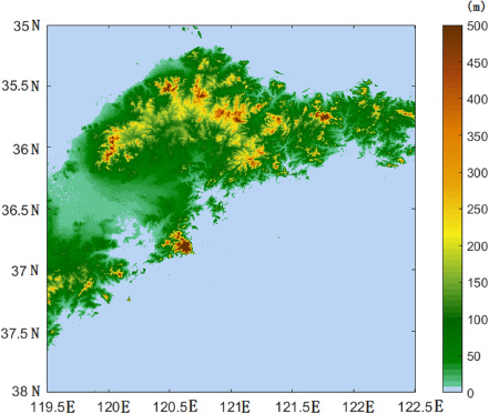
The actual ground surface around the east of Shandong Province.
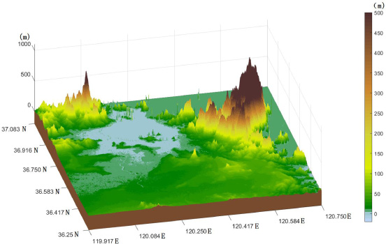
Schematic of the actual ground surface in Qingdao’s main urban area.
Assuming perfect lightning return-stroke conditions, the current at the base of the lightning return-stroke channel is:

The waveform of the current at the base of the lightning channel.
Parameters of the subsequent return strokes [25]
We use MTLL (the modified transmission-line model with linear current decay at height) [26] to model the return-stroke, obtaining:
We further use the Qingdao lightning strikes at 4th March 2018 and 6th May 2018 for lighting strike locations. Strike point 1 and strike point 2 have coordinates at (120.2155°E, 36.2908°N) and (120.451°E, 36.1619°N) respectively. Figures 4 and 5 show the RMSH of actual ground surface corrugations from different azimuths within 50 km around strike point 1 and strike point 2 (azimuths 0° due east, rotating anti-clockwise). It subsequently revealed that changes in location can lead to large differences in RMSH. When the azimuth is 346° within 50 km of strike point 1, RMSH peaks at 289.1 m. Whereas at 144°, lowest RMSH is merely 3.19 m. As for the surface within 50 km of strike point 2, RMSH was highest (283.67 m) at 11° and lowest (7.96 m) at 189°. The ground surfaces in the regions around the two strike points are extremely complex, and the degree of corrugation roughness varies greatly with location.
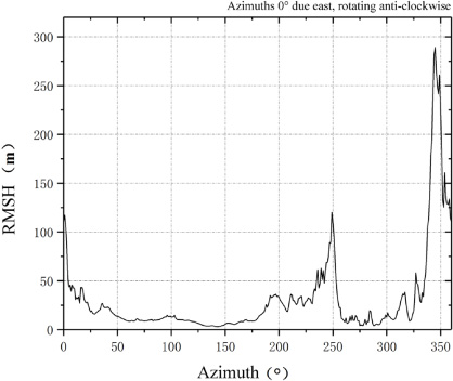
Actual surface RMSH at strike point.

Actual surface RMSH at strike point 2.
In order to study the effects of attenuation of lightning electric wave high-frequency components when lightning electromagnetic fields propagate along actual ground surfaces, this paper applies formulations by Barrick and by Wait, and investigates the properties of lightning electric wave propagation along actual ground surfaces. Figures 6 and 7 show the lightning vertical electric field waveforms within 50 km of both lightning strikes. Figures 6(a) and 6(b) show the lightning vertical electric field At azimuths 346 and 144 around strike point 1, where the RMSH corresponds to the highest and smallest values. Similarly, Figs 7(a) and 7(b) show the vertical electric fields at strike point 2 at azimuths 11° and 189°. We can observe that as the RMSH increases, the rise time of the vertical electric field waveform gradually increases, causing decreases in electric field peak value (albeit in a small magnitude). For instance, when the observation point is 50 km away from strike point 1 (azimuth 346°), the rise time of the vertical electrical field as it propagates over the actual ground surface is delayed by 0.5 μs compared to a perfectly smooth surface, and the peak value of the electrical field is reduced by 1.3%. An equivalent decrease in electrical peak value at strike point 2 occurs when the azimuth is 11° (delay in rise time of 0.25 μs, decrease in the peak value by of 0.6%).

The effect of actual ground surface on the lightning vertical electric field at strike point 1. (a) Azimuth 346°. (b) Azimuth 144°.

The effect of actual ground surface on the lightning vertical electric field at strike point 2. (a) Azimuth 11°. (b) Azimuth 189°.
According to Pifer et al. [8], the effects of ground surface on lightning location accuracy include time errors not only introduced by propagation over finite conducting rough ground, but also generated from the elongation of the propagation path of the signal caused by obstacles (mountains). Figure 8 shows path elongation distances within 50 km of strike points 1 and 2. Figure 9 shows time delays in propagation corresponding to Fig. 8. Research reveals that differences in azimuth induce great differences in path elongation distances, with the highest value of 1200 m and a corresponding time delay of 4 μs.

Path elongation induced by actual ground surfaces within 50 km.
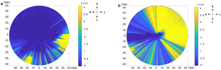
Time delays caused by actual ground surfaces within 50 km of the strike points. (a) Strike point 1. (b) Strike point 2.
Hence, both the reflection attenuation to lightning electromagnetic waves caused by rough surface and the path elongation effect generated by propagation along the ground surface can cause time delays in lightning electrical field waveform rise times, and furthermore, affecting the results of ToA-based LLS. This paper uses Qingdao as an example to comprehensively analyze the influence of actual ground surfaces on lightning location information and further, revise errors in lightning location information.
The four detection stations of the Qingdao LLS are: Jimo Station (120.469°E, 36.392°N), Rizhao Station (119.539°E, 35.432°N), Rongcheng Station (122.493°E, 37.17°N), Longkou Station (120.341°E, 37.64°N). Figure 10 shows the locations of the detection stations in the Qingdao LLS.
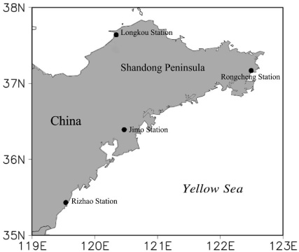
Lightning detection stations of the Qingdao LLS.
Here we consider the two Qingdao lightning strikes (4 March 2018 and 16 May 2018). We present unrevised location information generated from LLS that does not account for ground surface effects.
We have applied incorporated actual ground surface data into both the surface impedance method and the path elongation model and then sum up the increases in waveform, and rise time thus obtained. We tentatively refer to this method as the actual ground surface propagation model. By using our model to revise lightning strikes data, the results as shown in Fig. 11 and Table 2, where ‘
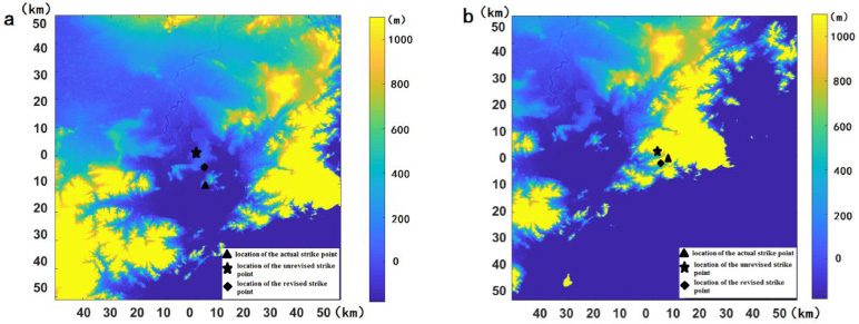
LLS lightning strike points revised by actual ground surface propagation model.
Parameters and results corresponding to Fig. 11
Conclusion
The more rough ground surface results into a more field attenuation and larger rise-time delay of field waveforms. Both the field attenuation to lightning electromagnetic waves caused by rough surfaces and the path elongation path elongation effect generated by propagation along the ground surface will induce time delays of field waveforms, and furthermore, affecting the results of ToA-based LLS. The ToA-based LLS errors of lightning Stroke Point 1 (120.2155°E, 36.2908°N) and Point 2 (120.451°E, 36.1619°N), which are caused by actual ground surface, are 2270 m and 790 m. The stroke points which are evaluated by the improved actual ground surface propagation model are closer to the actual lightning strike points.
Footnotes
Acknowledgements
This paper was financially supported by the 2019 annual research of key project of Shandong Meteorological Bureau (grant no. 2019sdqxz08) and 2019 Bohai Rim regional science and Technology Collaborative Innovation Fund (grant no. QYXM 201906). The authors express their sincere thanks to Professor Qilin Zhang for his helpful advice. Special thanks go to geospatial data cloud website for provided GDEM data. (![]() ).
).