
Abstract
Through analysis of environmental status of Xiong’an New Area, from three dimensions of water environment, atmospheric environment and geological environment, evaluation index system of environmental carrying capacity of the New Area is preliminarily designed. By using correlation analysis and principal component analysis, 11 basic indexes, including Industrial waste water discharge per 10000 yuan GDP, Comprehensive index of air quality and Average groundwater depth etc., are selected to construct the evaluation index system of environmental carrying capacity of Xiong’an New Area. Based on the fuzzy comprehensive evaluation method, the environmental carrying capacity of the New Area from 2014 to 2018 are evaluated, which provides the basis for protection and utilization of water environment, atmospheric environment and geological environment. The results show that: environmental carrying capacity of the New Area from 2014 to 2018 is 0.2186, 0.2109, 0.2153, 0.2415 and 0.2690 respectively, showing a steady growth trend, mainly as the environmental control of water and atmosphere have been strengthened after 2017.
Keywords
Introduction
From the perspective of environment, carrying capacity refers to the good environmental quality maintenance function of pollutant dilution and self-purification. Different from the regional resource carrying capacity which focuses on describing the population carrying capacity of regional resources (such as land resources, water resources, etc.), the regional environmental carrying capacity focuses on the corresponding regional economic scale, and tolerance and assimilation capacity of human survival and economic development to environmental space occupation, destruction and pollution [1]. As the core content of regional environmental carrying capacity evaluation, domestic and foreign scholars mainly follow the system theory and select evaluation indexes from multiple levels to design evaluation index system of regional environmental carrying capacity: Ruan [2] selected 15 basic indexes, mainly including groundwater exploitation rate, industrial solid waste emission and total control degree of land loss etc., to build evaluation index system of regional environmental carrying capacity. Nadia and Majid [3] selected 12 basic indexes to design the evaluation index system, such as cultivated land area per capita, water resource use amount per capita and available energy per capita etc. Wang [4] constructed the system covering multiple indexes of finance, economy and society. Malgorzata et al. [5] proposed a dynamic evaluation model of environmental carrying capacity covering various indexes, such as material capital, environmental quality and population. From three aspects of water environment, atmospheric environment and geological environment, several indexes, such as COD emission intensity, ecological water use rate, comprehensive index of air quality, land subsidiary rate and bearing capacity of building foundation etc., are selected to design the system [6, 7, 8, 9, 10, 11]. The above research findings provide a reference for the design of evaluation index system of environmental carrying capacity in Xiong’an New Area. However, as selection of evaluation indexes is mainly based on the qualitative analysis of influencing factors, there may be strong correlation between individual indexes, which is easy to lead to inaccurate evaluation results. Therefore, the quantitative research on indexes selection becomes very necessary. Through investigation current situations of water environment, atmospheric environment and geological environment in Xiong’an New Area, applying quantitative analysis methods of correlation analysis and principal component analysis of SPSS, the important characteristic indexes are selected to design the scientific and reasonable evaluation index system of environmental carrying capacity. Then, the environmental carrying capacity of the New Area is dynamically evaluated by fuzzy comprehensive evaluation method, so as to provide the basis for sustainable development of environmental system in the New Area.
The current situation of environment in Xiong’an New Area
Xiong’an New Area is a national new area established in 2017, which is located in the hinterland of Beijing, Tianjin and Baoding of Hebei Province. It is 105 km away from Beijing and Tianjin, 155 km away from Shijiazhuang and 30 km away from Baoding respectively. As shown in Fig. 1, it covers Xiong county, Rongcheng county and Anxin county (including Baiyangdian water area) of Baoding and its surrounding regions, with a total of 29 townships. The New Area has obvious location advantages, convenient transportation, excellent ecological environment, low degree of development, abundant development space, basic conditions of high starting point and high standard development and construction.
Planning diagram of Xiong’an New Area.
Firstly, water resources and water environment are the important support for the planning and construction of Xiong’an New Area. Secondly, Hebei Province has the worst air quality in China, and atmospheric environment in Xiong’an New Area needs to be improved. Thirdly, analysis of geological environment bearing capacity is the basis of planning and construction of Xiong’an New Area. Therefore, the environmental status of the New Area is analyzed from three aspects of water environment, atmospheric environment and geological environment, so the construction of evaluation index system of environmental carrying capacity in the New Area.
Water environment of Baiyangdian Lake water area
As the largest freshwater lake in the North China Plain, Baiyangdian Lake water area is 366 km
Baiyangdian Lake is characterized by phosphorus limitation and belongs to nitrogen pollution type. From 2009 to 2018, the average COD in Baiyangdian district is between 25.24
Water environment of the New Area
In 2016, annual average concentration of COD in the Daqing River basin where Xiong’an New Area is located reached level III water quality standard, and annual average value of ammonia nitrogen concentration is level IV water quality standard [14]. The pollution of water environment in the basin is mainly concentrated in industry and agriculture. In 2018, the average COD emission intensity in Xiong’an New Area is 11.12 kg/10000 yuan (from 2014 to 2018, the COD emission intensity in the New Area is 14.50 kg/10000 yuan, 14.82 kg/10000 yuan, 15.63 kg/10000 yuan, 12.97 kg/10000 yuan and 11.12 kg/10000 yuan), as shown in Fig. 2, which is lower than that of Hebei (15.3 kg/10000 yuan), but much higher than that of the whole country (3.8 kg/10000 yuan).
In 2018, unit effective irrigation area of the New Area is 0.43 hm
Water pressure indexes of Xiong’an New Area, Gaoyang County, Hebei and China in 2018
Water pressure indexes of Xiong’an New Area, Gaoyang County, Hebei and China in 2018
Unit effective irrigation area
Change of COD emission intensity in Xiong’an New Area from 2014 to 2018. COD emission intensity 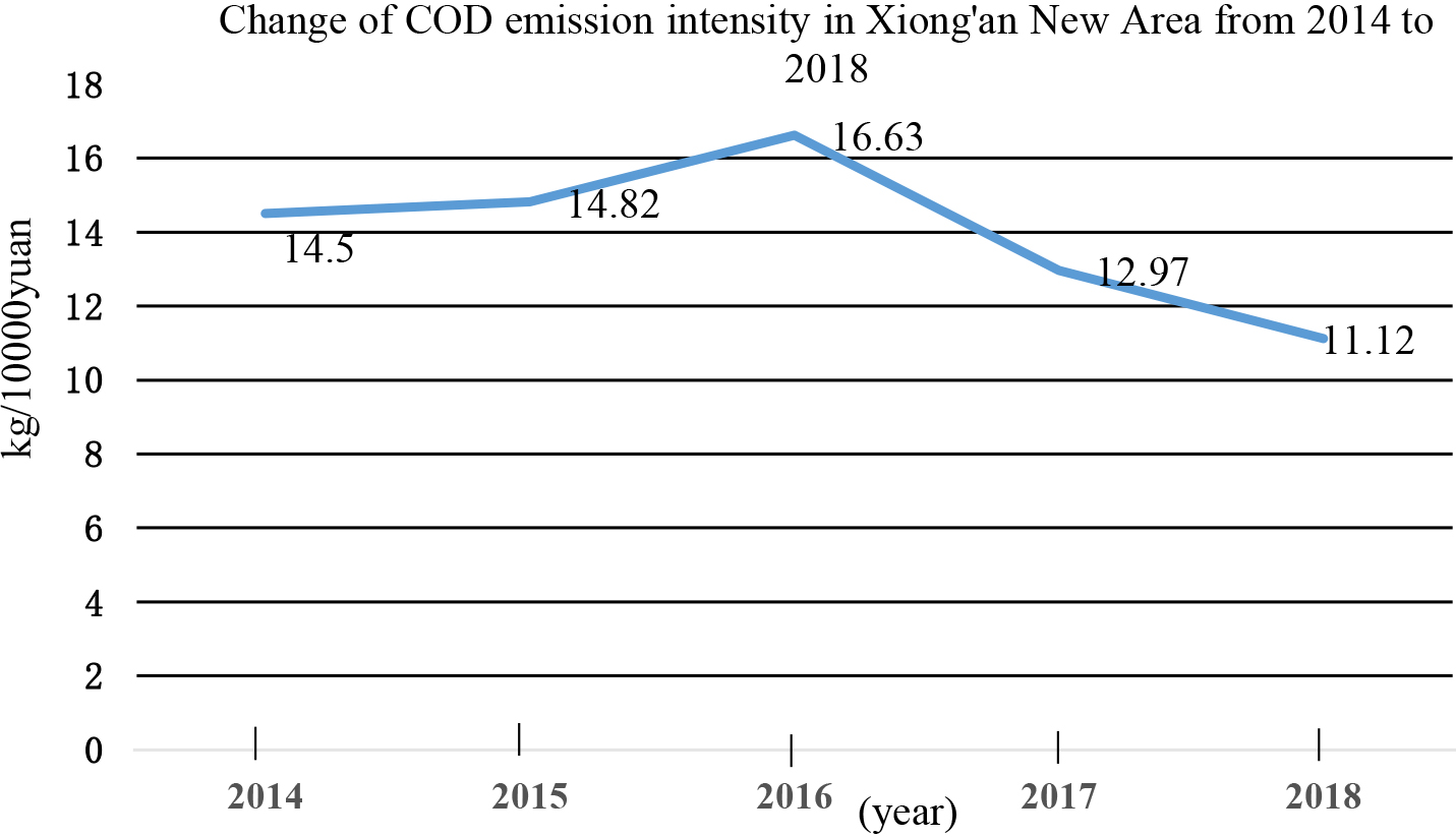
Xiong’an New Area is located in the middle latitude zone, with a temperate continental monsoon climate and four distinct seasons. The annual average temperature is 11.9
Comparison of air pollutant concentration between Xiong’an New Area, Gaoyang County, Hebei Province and China in 2018
Comparison of air pollutant concentration between Xiong’an New Area, Gaoyang County, Hebei Province and China in 2018
The standard used to calculate standard exceeding rate is the national air quality Level II standard. The above data are from the Bulletin of China’s Ecological Environment, Environmental Status Report of Hebei Province and Environmental Bulletin of Baoding City.
The Xiong’an New Area belongs to the transitional zone from Taihang piedmont plain to alluvial plain. The whole area of the New Area is higher in the northwest and slightly lower in the southeast, with an elevation of 7–19 m and a natural longitudinal slope of about 1/1000, which is a gently inclined plain. The engineering geological conditions are good within 100 m of surface buried depth in the New Area, however, there are five kinds of adverse geological processes, such as land subsidence, ground fissure, sand liquefaction, weak soil and soil erosion.
In terms of hydrogeological conditions, the stable field and basically stable site account for 89.5% of the total area in the New Area. There are three layers of underground space below 70 m, which can be used as the favorable layer for the main development and utilization of underground space. Except that the buried depth of water level of Baiyangdian Lake and surrounding areas is less than 5 m, the buried depth of other shallow groundwater levels is between 5 m and 25 m. In terms of geological structure conditions, the bearing capacity of the foundation within the depth of 0
Preliminary construction of evaluation index system of environmental carrying capacity in Xiong’an New Area
Preliminary construction of evaluation index system of environmental carrying capacity in Xiong’an New Area
Evaluation index of environmental carrying capacity of Xiong’an New Area after correlation analysis
Total variance explained
Extraction Method: Principal Component Anaylsis.
Design ideas
Firstly, from three dimensions of water environment, atmospheric environment and geological environment, the integration index of secondary standard layer and several basic indexes are selected according to current environment situations and development plannings of the New Area. Secondly, through correlation analysis of SPSS, some basic indexes with significant correlation are eliminated. Thirdly, through principal component analysis of SPSS, the mainly basic indexes affecting environmental carrying capacity of the New Area are found out. Finally, it is designed by a scientific and reasonable evaluation index system of environmental carrying capacity in the New Area.
Design of evaluation index system
Based on the three second-level indexes of water environment, atmospheric environment and geological environment of Xiong’an New Area, a total of 26 tertiary indexes, which can best reflect the environmental characteristics of the New Area and can be obtained by statistical data or calculation, are selected to preliminarily construct the environmental carrying capacity evaluation index system of Xiong’an New Area, as shown in Table 3. Taking Xiong, An’xin and Rongcheng county (including Baiyangdian Lake) of Xiong’an New Area as the main evaluation unit, the research data are the statistical index data of the New Area from 2014 to 2018, which are all from Hebei Environmental Status Bulletin, Baoding Water Resources Bulletin, Research Report on Development of Xiong’an New Area, official website of the New Area, officials websites of Xiong, An’xin and Rongcheng county, field investigation or calculation.
In this paper, correlation analysis and principal component analysis of SPSS are used to screen environmental carrying capacity evaluation indexes of the New Area.
Step One: Correlation analysis based on SPSS [17]. Firstly, the statistical data of 26 indexes of water environment, atmospheric environment and geological environment in Xiong’an New Area from 2014 to 2018 are standardized. Secondly, the correlation analysis method of SPSS tool is used to conduct correlation test to find out the significant correlation indexes (absolute value of correlation coefficient
Rotated component matrix
Rotated component matrix
Extraction Method: Principal Component Anaylsi, Ratation Method: Varimax with Kaiser Normalization.
Step Two: Principal component analysis based on SPSS [17]. Firstly, the statistical data of 19 indexes of water environment, atmospheric environment and geological environment in Xiong’an new area from 2014 to 2018 are standardized. Secondly, the principal component analysis method of SPSS tool is used for analysis, as shown in Tables 5 and 6. In Table 5, the eigenvalues of the first four principal components of the environmental carrying capacity index are all greater than 1, and the cumulative contribution rate is more than 80%, indicating that these four principal components can basically represent the original indexes to evaluate the environmental carrying capacity of the New Area. Finally, the relevant indexes are extracted based on principal component analysis. By analyzing the factor load matrix after rotation (as shown in Table 6), 11 indexes, including Industrial waste water discharge per 10000 yuan GDP, Daily treatment capacity of urban sewage, COD emission intensity, ecological water use rate, air quality comprehensive index, PM
Basic steps of fuzzy comprehensive evaluation method
The main steps of fuzzy comprehensive evaluation method are as follows [18]: (1) Determine the set of factors. (2) Determine the set of comments. The level
The comprehensive evaluation formula is as follows in Eq. (1),
In this paper, taking water environment carrying capacity evaluation in Xiong’an New Area as an example.
Step One: Set classification criteria of evaluation index. According to international water environment evaluation standard and surface water environment quality standard (GB3838-2019), combined with national water environment situation, Baoding city water environment condition of Hebei Province, water environment condition of Xiong’an New Area and development plan of the New Area, the classification criteria of water environment carrying capacity of Xiong’an New Area is formulated, as shown in Table 7.
The classification criteria of water environment carrying capacity evaluation index in Xiong’an New Area
The classification criteria of water environment carrying capacity evaluation index in Xiong’an New Area
Step Two: Determine the weight of each index.
Principal component analysis method is used to determine the weight of second-class evaluation indexes, as shown in Table 8.
Weight of each evaluation index of water environment in Xiong’an New Area
The weight matrix
Step 3: Evaluate water environment carrying capacity.
First of all, the evaluation matrix
Secondly, calculate the comprehensive evaluation matrix. Through fuzzy transformation, take 2014 as an example, get the comprehensive evaluation matrix
In this way, the comprehensive evaluation Matrix
Based on Eq. (1), the evaluation results of water environment carrying capacity in Xiong’an New Area from 2014 to 2018 are as follows in Table 9.
Evaluation results of water environment carrying capacity in Xiong’an New Area from 2014 to 2018
Similarly, the comprehensive evaluation results of atmospheric environmental carrying capacity and geological environmental carrying capacity of Xiong’an New Area from 2014 to 2018 are obtained, as shown in Tables 10 and 11 respectively.
Evaluation results of atmospheric environment carrying capacity in Xiong’an New Area from 2014 to 2018
Evaluation results of geological environment carrying capacity in Xiong’an New Area from 2014 to 2018
The weights of water environment, atmospheric environment and geological environment in Xiong’an New Area are 0.5, 0.25 and 0.25 respectively by using expert scoring method. By using the Eq. (8), the evaluation results of environmental carrying capacity of Xiong’an New Area from 2014 to 2018 are obtained, as shown in Fig. 3.
Environmental carrying capacity of Xiong’an New Area from 2014 to 2018.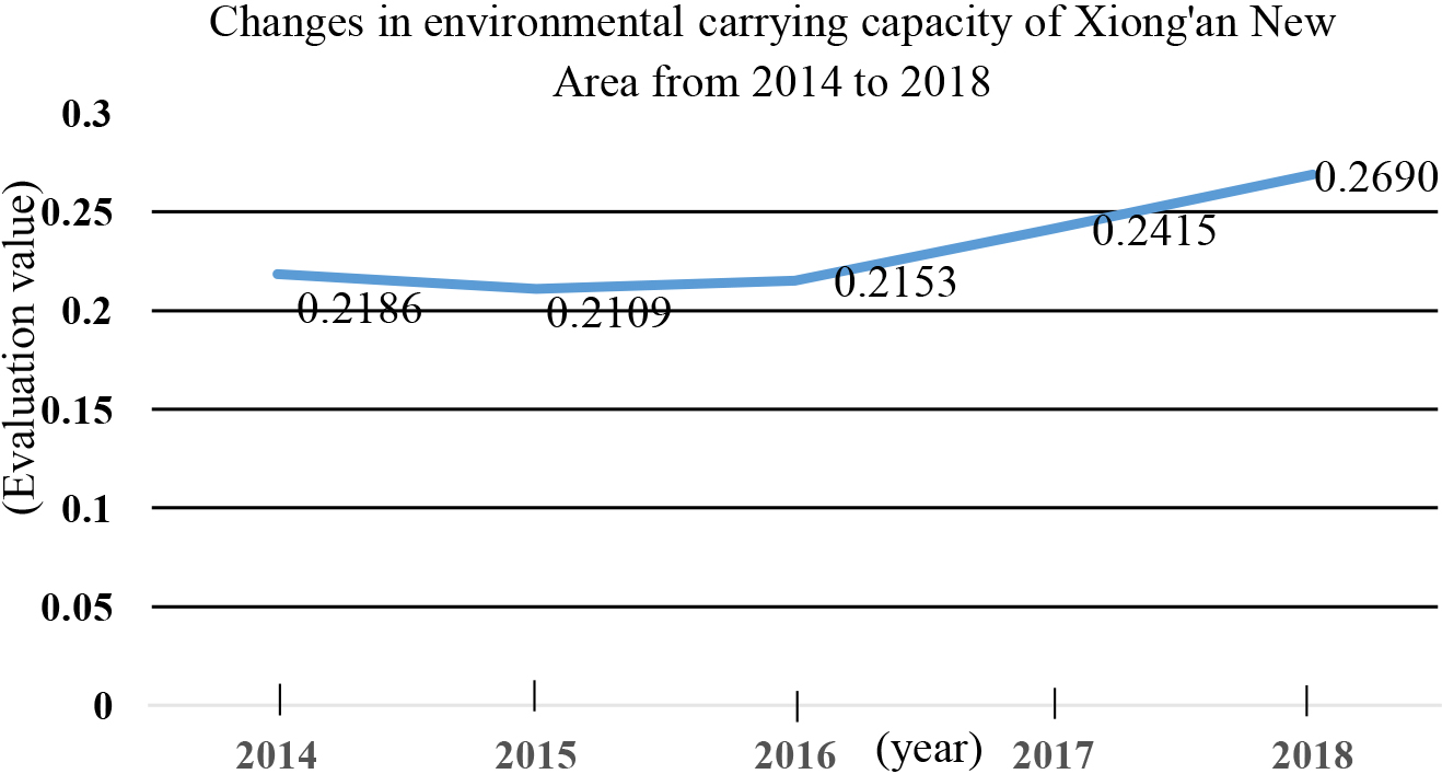
From 2014 to 2018, environmental carrying capacity of the New Area fluctuate from 0.21 to 0.27, and environmental carrying capacity is weak. Since 2017, the New Area began to strengthen environmental governance, so environmental carrying capacity showed an upward trend.
Compared with previous research findings that only rely on qualitative methods to select evaluation indexes, in this paper, combination of qualitative and quantitative methods is used. From qualitatively proposing various evaluation characteristic indexes to quantitatively identifying the main influencing factors, so as to screen evaluation indexes and avoid problem of strong subjectivity caused by lack of quantitative analysis, the basic indexes without information duplication are screened out, which can fully reflect the main characteristic indexes of the environmental characteristics and core elements of the New Area. A more scientific evaluation index system of environmental carrying capacity is built, which provides ideas for the construction and research of evaluation index system of regional environmental carrying capacity.
In the process of selecting basic indexes, the principles of scientificity, systematicness and dynamics are mainly followed, availability, integrity and operability of indexes data are given priority consideration. Because some indexes data cannot be obtained through field research, statistical annual signature query and other methods, environmental carrying capacity of the New Area may not been evaluated comprehensively. In the follow-up research, some basic indexes will be chosen from more aspects, such as ecological flow assurance rate, aquatic animal and plant diversity, public satisfaction and other indexes related to water environment et al., so as to select basic indexes as comprehensively as possible and draw a more reasonable research conclusion.
At the same time, environmental carrying capacity of the New Area is evaluated in this paper. For the one thing, in terms of evaluation methods selection, because environmental carrying capacity evaluation of the New Area is a complex problem, various factors will affect the evaluation effect of environmental carrying capacity, and the ways and sizes of influence are different and fuzzy. Therefore, fuzzy comprehensive evaluation method is used to analyze the environmental carrying capacity of the New Area, which can objectively reflect these effects. According to the membership theory of fuzzy mathematics, the qualitative evaluation is transformed into quantitative evaluation, which is scientific and feasible. In view of the strong subjectivity of determining the indexes weight by fuzzy comprehensive evaluation method, use principal component analysis method to calculate the basic indexes weight, so as to ensure the objectivity of the indexes weight calculation. For another thing, due to the epidemic situation, field investigation cannot be carried out after 2019, it is only selected 2014–2018 to evaluate environmental carrying capacity of the New Area. Because time scale of five years is relatively short, it may affect objectivity of evaluation results to a certain extent. Therefore, in the follow-up research, it is necessary to continue in-depth field investigation to obtain indexes data of more years, so as to improve scientificity of evaluation in the New Area.
Conclusion
Through in-depth study of environmental situations of the New Area, from three aspects of water environment, atmospheric environment and geological environment, 26 basic indexes with typical representative significance are qualitatively selected, which can fully reflect the required characteristics of all aspects of regional environmental carrying status. On this basis, the quantitative analysis methods are used to screen the basic indexes. Firstly, the correlation analysis method of SPSS is used to eliminate 7 basic indexes with significantly related information repeatability. Secondly, the principal component analysis method of SPSS is used to extract the main factors affecting the environmental carrying capacity of the New Area, and 8 basic indexes are screened out. Finally, 11 basic indexes are selected to design evaluation index system, and the environmental carrying capacity of the New Area from 2014 to 2018 is comprehensively evaluated. According to evaluation results, the environmental carrying capacity of the New Area is between 0.21–0.47, which needs to be further improved in the future.
Policy recommendations
Regional environmental carrying capacity is an important index to judge the coordination between regional environmental system and economic and social activities. Scientific evaluation of it can clearly understand the critical point of appropriate carrying capacity of regional environmental system. Some policy recommendations are put forward to improve the environmental carrying capacity of the New Area from three aspects of water environment, atmospheric environment and geological environment.
(1) From 2014 to 2018, water environment carrying capacity of Xiong’an New Area is 0.2161, 0.2130, 0.2200, 0.2679 and 0.3182 respectively. Since 2017, because water environment treatment has been strengthened in the New Area, water environment carrying capacity shows an obvious upward trend from 2017 to 2018. In the future, water environment carrying capacity of the New Area should be improved from two aspects of water environment protection and water environment governance. In terms of water environment protection, carry out legislation, give full play to the ecological function of Baiyangdian Lake, strictly control over exploitation of groundwater, actively guide the extensive participation of all sectors of society. In terms of water environment treatment, control pollution and ensure the water environment in the New Area, focus on the comprehensive improvement and ecological restoration of Baiyangdian basin.
(2) From 2014 to 2018, atmospheric environment carrying capacity of Xiong’an New Area is 0.1296, 0.1214, 0.1190, 0.1589 and 0.1832 respectively, which is relatively low, mainly due to the poor air environment quality in Beijing-Tianjin-Hebei before. Since 2017, because air governance has been strengthened in Xiong’an New Area, atmospheric environmental carrying capacity has shown an upward trend. The main countermeasures to improve the atmospheric environmental carrying capacity of the New Area could include: continuously promoting clean heating, accelerating the upgrading of boiler transformation, strengthening the source control of motor vehicles, promoting the construction and application of monitoring system, further checking again and renovating “scattered pollution” enterprises, and promoting the deep treatment of volatile organic compounds.
(3) From 2014 to 2018, geological environment carrying capacity of Xiong’an New Area is 0.3123, 0.2962, 0.3021, 0.2713 and 0.2563 respectively, which shows a slow decline trend, mainly due to excessive exploitation intensity of groundwater. The main countermeasures could include: strictly control over exploitation of groundwater to prevent continuous land subsidence, strengthen the treatment of soft soil and the prevention of sand liquefaction to deal with the risk of geological disasters, establish the flood disaster risk monitoring and early warning system.
Footnotes
Acknowledgments
This study is supported by High Level Incubation Research Project of Beijing Union University (Grant No. SK80202103).