
Abstract
In rural construction, affected by covid-19, it leads to the collection and demand survey of basic information data of relevant interest groups. The specific situation of the transformation of ancient villages is also gradually increasing. However, due to the complexity of rural space, the dispersion of settlement space and the diversity of information demand of rural planning work, the data coverage is large, information acquisition is difficult, the use effect of data collection is not ideal, and there is no planning feedback mechanism. However, during the epidemic period, the staff could not carry out a series of reconstruction of ancient villages. At present, the data of village planning and construction and architectural design are complex, the needs of relevant interest groups are diversified, and regional planning is difficult. In this paper, the big data function is applied to the reconstruction of ancient villages in the epidemic period of covid-19.
Keywords
Introduction
With the continuous development of computer and Internet technology, after several technological revolutions, in today’s information explosion era, big data has begun to step onto the historical stage, we ushered in the era of big data, which is setting off a comprehensive innovation of our life, work and thinking mode [1]. Based on this, in the field of village planning and rural architectural design, researchers have begun to explore the application of big data in village planning and rural architectural design and made relevant progress [2–5]. In the field of village planning and rural architectural design, due to the complexity of the village itself and the diversity of rural planning work needs, the data breadth and the difficulty of access have increased. However, rural planning has big data characteristics in basic data research and multi-user demand [6–11]. Taking a village as an example, on the basis of summarizing the technical problems of village planning, this paper combs the acquisition and processing means of planning data affected by the arrival of big data, mainly studies the transformation trend of village planning and rural architecture design from the basic research means and sample selection of village planning, the focus of village planning and village evaluation system. Using the thinking mode and technical means of big data, it provides a platform for villagers’ participation, village display, design exchange and government decision-making for village planning and rural architecture design. Therefore, this study attempts to explore the application of village planning and rural architecture design from the perspective of big data [12].
China’s “diagnosis and treatment plan” on aerosol Description: in relatively closed environment exposed to high concentration aerosol for a long time, or in the case of aerosol production operation, there is the possibility of aerosol transmission. When pathogens are discharged from patients’ respiratory tract, the size of particles formed determines whether they are transmitted by droplets or aerosols. Studies have confirmed that coronavirus and influenza virus are discharged in the form of droplets, not in the form of aerosols at the beginning. Because the droplets can be converted into aerosols in the external environment, especially in the airtight space with poor ventilation, the larger particles of the droplets can remove part of the water, and become the small particles of aerosols, which can achieve a long-distance transmission.
Room ventilation can dilute the virus concentration and reduce the risk of infection, which is very important to prevent aerosol transmission. In addition, the spread of aerosols depends not only on the distance, but also on the size of aerosol particles, air velocity, and the stability of micro-organisms in aerosols, the susceptible and other factors. As a result, the transformation of ancient villages has been greatly affected.
During the outbreak, all staff were restricted. The transformation of the ancient village was affected. At the same time, based on the perspective of big data, the collection and preservation of ancient village data during the epidemic can be solved. The transformation work after the epidemic continued [13].
Technical problems in the reconstruction of ancient villages
The reconstruction planning of ancient villages belongs to the special planning, which should be restricted by the upper legal planning. However, the preparation of the regulatory detailed planning in China fails to achieve the full coverage of urban construction land, and the regulatory detailed planning often loosens the control requirements of the ancient village area, which directly leads to the lack of guidance from the macro level of such reconstruction planning, which cannot achieve the expected effect of the planning. The problems to be solved in the reconstruction planning of ancient villages are multi-level, involving multi-party interest groups, which requires the planning to improve the ability of data collection and processing, and enhance the scientificity of planning results, but the traditional quantitative analysis method obviously cannot provide enough technical support [14–17].
Due to the limited technical capacity, the basic data used in the quantitative analysis of traditional transformation planning are mostly sampling data and census data. Because of the limitation of sampling method, there is always a certain gap between sample data and actual data, sometimes even some irreconcilable contradictions. The latter mainly comes from the census data dominated by the government, but these census cycles are mostly based on “year", and the accuracy is relatively rough, so that the data obtained has “lag” to a large extent, which brings certain negative effects to the planning results [18–21]. To sum up, the traditional reconstruction planning of ancient villages has abandoned the individual behavior research that requires refined data, on the contrary, it emphasizes more on the group behavior characteristics at the macro level, and establishes the planning on the more fuzzy data qualitative analysis, which makes the planning results difficult to implement due to the inconsistency with the actual development of villages in the city.
On the one hand, it is limited by the defects of data quality and quantity, on the other hand, it is limited by the backward analysis methods, and the traditional planning methods rely too much on manual analysis and judgment. In the basic research, some influencing factors that are not easy to analyze are often ignored artificially, and the research method of few variables is adopted to simplify the complex problems. This leads to the lack of understanding of the internal and objective laws of the ancient village, and the inability to clarify the relationship between the development constraints of various elements, thus losing the fundamental significance of guidance and constraints.
A scientific plan for the reconstruction of ancient villages is inseparable from the public participation of both breadth and depth. The development and transformation of ancient villages involves six important interest subjects, including three main interest subjects (government, villagers, open businessmen) and three sub interest subjects (low rent groups, commercial housing residents, all residents in the region), of which the government is the spokesman of the sub interest subjects. The transformation planning which can promote the healthy development of ancient villages should be in line with the value orientation of public interest and realize the fair distribution of interests as much as possible in the multi interest game. At present, although the transformation plan focuses on the balanced distribution of interests and introduces the mechanism of public participation, the essence of the plan is still in the “expert led” preference to meet the interests of the main power.
The reconstruction planning of ancient villages is comprehensive, and its implementation affects the city in many aspects, so it is difficult to meet the scientific requirements of the reconstruction planning only by relying on the strength of the government planning department. However, at present, the preparation of transformation planning is often undertaken by the planning department or the entrusted design unit independently. The lack of professional advice and guidance from other departments or fields may lead to improper connection of transportation, environmental protection, infrastructure and other aspects, resulting in new urban problems and hindering urban development.
The role of big data in the reconstruction planning of ancient villages
In today’s society with the rapid development of information technology, the concept of big data is first responded in the field of it, and then rapidly valued in various fields such as finance, commerce, medical treatment, transportation, etc. the field of urban and rural planning has also been given many characteristics of the times and new development propositions. For the reconstruction of ancient villages, big data not only provides a rich data base, but also brings new opportunities for its development, and its technical methods of planning are facing innovation. In the era of big data, there are rich and comprehensive data types, such as smart phone data, vehicle GPS, Internet of things data, social media data and so on. At the same time, it is equipped with advanced data processing technology. Compared with the traditional small sample data, the reconstruction planning of ancient villages can obtain the construction and use of social, economic, cultural and other related facilities inside and outside the planning area more efficiently and accurately. Through the high-speed storage and efficient processing of massive data, and the early stage of data collection and collation of ancient village reconstruction planning, we can get rid of the shackles of the accuracy and timeliness of traditional planning data, complete the transformation from macro group research to micro individual research, and conduct dynamic factor research, so as to provide a more reliable basis for planning. Further in-depth processing of big data can enlarge the value of data research and provide more basis for planning and decision-making that traditional data cannot provide. For example, large data can be used to establish various types of complex models related to planning decision-making, and simulate the planning results, so that the planning results can be visualized, and the implementation effect of planning can be more intuitively estimated as a reference for decision-making. In addition, based on the real-time nature of big data, the implementation of planning can be tracked and monitored so as to timely feedback the implementation effect. Because the ancient villages that need to be reconstructed are often in the center of the urban built-up area, the effect of planning and implementation directly affects the basic and non-basic functions of the whole city. Improper construction is avoided. Rationality is ensured in the planning. In the planning of transformation, we should strengthen the prediction and evaluation of the implementation of the planning, and transform the ancient village step by step, so that it can be integrated into the whole urban functional system. Big data provides a basic data platform for the planning department and other departments to participate in the planning and decision-making of ancient village reconstruction. In the system reform from planned economy to market economy, China has formed a set of intersecting spatial planning system [12]. The core research object of spatial planning is the same urban and rural space, which usually involves many fields when solving a certain urban problem, and reflects the different parallel departments in the setting of government agencies. These parallel departments are seriously divided, which leads to the low level of cooperation between departments, which is not conducive to the healthy development of the city. The information sharing platform based on big data can provide technical support for cooperation between departments. At the same time, the further opening of the authority of the sharing platform can make up for the deficiencies of traditional ways of public participation, such as propaganda and questionnaire survey, and provide a more convenient way to avoid the formalization of public participation, and effectively expand the level of public participation.
Methods
At present, there is no unified definition of big data, but it is generally believed that big data needs to meet the four characteristics of volume, variety, velocity and value. The research of big data is to sort out these data through data mining, knowledge discovery and deep learning, and form valuable data products, which are provided to the government, industry enterprises and individual Internet users for use and consumption. Generally speaking, big data refers to the data with large capacity, multi category, and value after being processed by certain technical means, and with fast response speed of processing and retrieval. Big data is not only a leap in technology, but also a change in the way of thinking. Its basic idea is to integrate the scattered resources and play a greater role.
Big data features
In the face of data goal oriented decision-making: the goal is clear and the demand is quickly positioned to facilitate decision-making. Classification data - data value orientation: quickly mining valuable data for collection and reprocessing. Use data - efficient use orientation: improve data use efficiency by reusing data. Therefore, big data thinking, starting from the ultimate purpose of data application, is to extract and mine data value from massive heterogeneous data, and quickly locate valuable data, so as to provide basis for decision-making and prediction.
The significance of promoting rural planning and rural architecture design with data information
(1) From the natural ecology, human environment, settlement space and other perspectives, the information collected from the village status survey is classified. (2) Through the analysis of the elements that affect the village planning and architectural design, the important influencing factors are selected from the regional style, spatial pattern, human folk custom, settlement form, architectural form, economic industry and other aspects to form a parameter evaluation system and scoring mechanism. (3) A feedback mechanism based on big data is established to optimize village planning and rural architectural design in combination with the evaluation system and scoring, forming a new idea of village planning and construction and rural architectural design from the perspective of big data. In the village planning and construction and rural architecture design, the working mode of big data thinking is adopted. From the collection and extraction of basic data to the positioning and subdivision of value data, the principles and methods of village planning and rural architecture design under big data thinking are discussed. The process of village planning and construction and rural architecture design has been promoted. The planning and construction of villages and the design of rural buildings are optimized. The scientific decision-making of the government and the working efficiency of the designers in rural planning are aimed at improving. Villagers’ right to participate in rural planning is guaranteed.
Big data characteristics of village planning
Rural planning involves diverse interest groups, complex basic data and diverse data types. The characteristics of massive heterogeneous data of big data are volume and variety. At the same time, due to the content, characteristics and purpose of rural planning. The speed and value characteristics of big data are possessed. The characteristics of village planning in three aspects of administrative division, natural geography and social and cultural attributes are particularly prominent from the perspective of big data:
On the attribute of administrative division. As the smallest administrative unit of the administrative division level in China, the basic data of different categories are distributed in different administrative levels at the same time, and the administrative levels of the data sources are diverse. For example, the specific personnel of the village group is at the level of the village group, the rural economic data is at the level of the township, and the regional development orientation and large-scale infrastructure information about the village can only be obtained at the level of the county and the city. Therefore, the administrative division attribute of rural areas has created the extensive characteristics of rural planning data sources.
Physical geographical attribute. The natural geographical location and agricultural industry characteristics of rural areas make their dependence on natural ecological environment much greater than that of cities. Therefore, the demand of rural planning for natural resources and ecological environment data is far greater than that of urban planning. The in-depth investigation of natural resource condition survey data and geographic information data increases the complexity of data content.
Social and cultural attributes. Compared with the openness of the city, the self-sufficient mode of production and the barrier of space and transportation in the countryside are relatively closed. This closeness has created the unique social and cultural characteristics of the countryside. Its own accumulation and formation of historical and cultural heritage and profound and distinctive cultural information are also the value data that rural planning needs to focus on. For example, rural folklore, historical stories and other information data need to be obtained through in-depth interviews and surveys; while traditional buildings that show the unique features of rural areas need to be recorded on-site mapping. Therefore, it not only increases the diversity of rural planning data content, but also increases the diversity of data acquisition path and form.
In the village planning, all the quantitative and qualitative analysis are mostly based on the data of basic research. The data of traditional quantitative analysis can be obtained through field investigation, questionnaire, statistical yearbook and related books. Generally, it studies the basic data, census data, land use data, social and economic development data of villages, and stores and analyzes them in the form of words and numbers. Generally speaking, the traditional field survey and questionnaire survey are easy to obtain the latest first-hand data, but there are some defects, such as small sample size, strong subjectivity, high cost and long cycle, and the workload is large.
Through the feedback mechanism of big data, we can obtain the relevant information of rural planning and construction, form a set of evaluation system and scoring system to optimize the village planning and rural architectural design, and improve the efficiency of village planning and construction. The evaluation system is as follows:
(1) Basic principles of evaluation system
To promote the design and construction of village planning, we should fully consider the symbiotic collection mode of “people", “culture” and “green". This collection mode takes the beautiful scenery as the extreme symbiosis, that is, the natural ecological beautiful environment, the humanistic beautiful environment and the human settlements beautiful micro environment.
Village planning must have four indivisible basic characteristics. Beauty of production: the industrial development mode is scientific, modern agriculture features prominently, and farmers’ employment and income increase are obvious. Beauty of life: the villagers have a comfortable life, high income level, convenient living conditions and civilized lifestyle. Environmental beauty: the ecological environment is beautiful, the village courtyard is clean and tidy, showing the characteristics of landscape. Humanistic beauty: the rural style is civilized and harmonious, the relationship between cadres and masses is harmonious, the moral fashion is good, and the cultural activities are healthy.
Evaluation index system of village planning
The main indicators of the evaluation system of beautiful villages in China are as follows:
First level indicators: (1) environmental ecosystem; (2) village planning system; (3) village planning system; (4) humanistic connotation system; (5) public service system; (6) economic structure development system; (7) brand image system.
Second level indicators: take natural villages as the main evaluation objects, including new communities where some villages are relocated. The secondary index auxiliary reference index is shown in Table 1.
Index system of double interest for village planning evaluation
Index system of double interest for village planning evaluation
The weight ratio of the evaluation system is as follows. Environmental ecosystem: 18%; village planning system: 16%; residential health system: 20%; humanistic connotation system: 12%; public service system: 9%; economic structure development system: 15%; brand image system: 10%.
There is a village in Central China. The total area is 934.6 hm 2, the altitude is 1600-1800 m, and the location advantage is obvious. Kedaxing natural village is located in the south of Daye City, Hubei Province, with an east longitude of 115.018 degrees and a north latitude of 29.997 degrees. The second ancestor Shuntong officially settled down and started his business. Since the Chenghua period of the Ming Dynasty, it has a history of more than 500 years, passed on for more than 20 generations, and formed an ancient village with more than 200 households and more than 1000 people.
The main contents of village planning and construction are summarized as follows: building renewal construction, road repair and dredging, supporting facilities construction, environmental remediation, etc. taking each main content as the evaluation index, on the one hand, to ensure the integrity of the planning content, on the other hand, to evaluate the rationality of each content. The plan emphasizes public participation. Application is the best way for government departments and planning units to communicate and understand with the public. It is also an important process to improve the practicability of planning and promote the implementation of planning. In the implementation, it is more necessary to ensure the economic feasibility of the planning scheme. If the legal and administrative feasibility, implementation measures and contents of the plan are operable, experts need to understand the local actual situation in detail and then make a judgment. Therefore, mandatory indicators are mainly based on the legality, standardization and perfection of planning content, respect public opinion, make planning decision more reasonable, and ensure the smooth progress of planning.
On March 31, 2018, the rural sustainable innovation research alliance in Central China was implemented in a village, establishing a sustainable and close relationship.
The seminar was jointly held with urban and Rural Development Planning Bureau, domestic and foreign university rural construction researchers, members of Northwest sustainable innovation rural research alliance and Architectural Design Institute Co., Ltd., and other rural revitalization research and design forces established an information platform in a village. Through the establishment of the information platform, the following information can be obtained: Discussion of rural development planning in the management area, design of housing renovation, technical support for building renovation and repair, suggestions for selection of building materials, etc. And obtain continuous intellectual support in the follow-up work.
A village in the management area was selected as the designated base for the 2018 central China rural planning competition for college students. Through the organization of competition activities, we can get extensive attention from social forces and resources. The competition program can provide a strong reference for village planning and development direction.
Establish scientific research information in Colleges and universities, fully collect the wishes and suggestions of local villagers, and make statistical classification of data. Analyze information data from multiple perspectives. A variety of technical means have been adopted. It solves the actual needs of villagers and provides more information support and path selection for scientific village planning. A new direction of village planning of “thinking technology strategy” has been formed. The idea of big data is introduced into village planning. The technical strategies for village planning are discussed. The further development of villages will inject infinite vitality and accelerate the development of urban-rural integration.
Village planning should involve the whole process of villagers and collect information through big data. Despite the low level of public participation and the Limited dissemination of planning information, the villagers still have strong willingness to participate. In Dahuang village, Baili Azalea management area, Guizhou Province, they actively appeal to the villagers to participate in the rural planning and construction work and form data information to guide and better improve the rural planning and rural architectural design. The design drawing of ancient village reconstruction based on big data is shown in Fig. 1
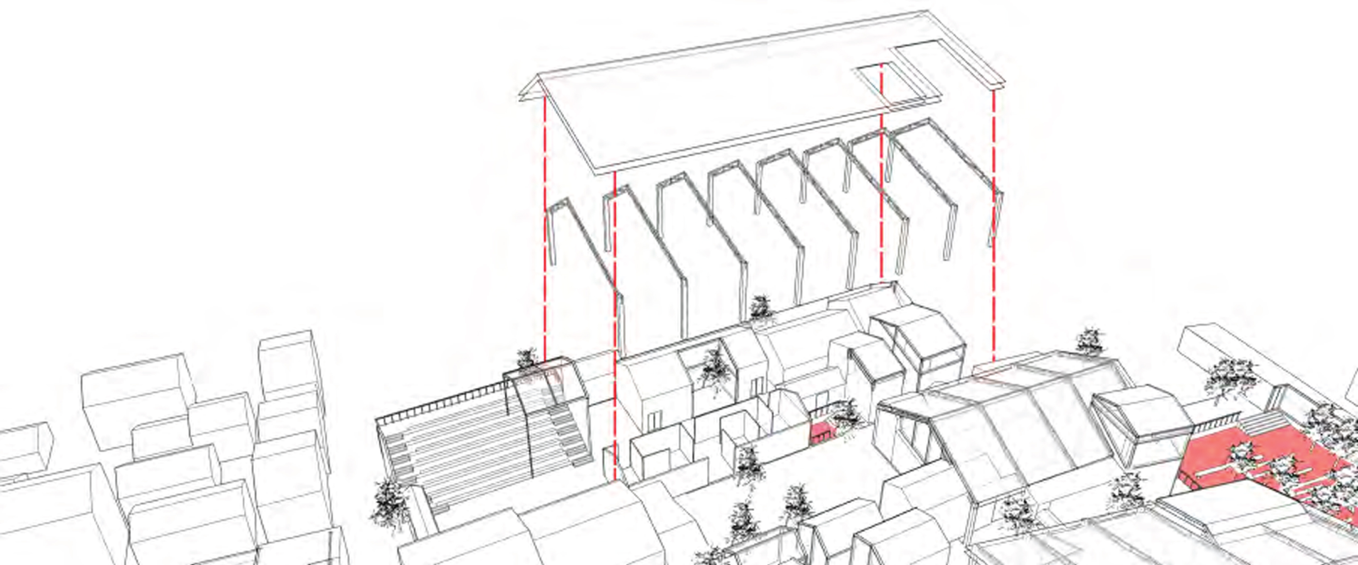
Old village reconstruction design drawing based on big data.
The overall planning of ancient village based on big data is shown in Fig. 2.
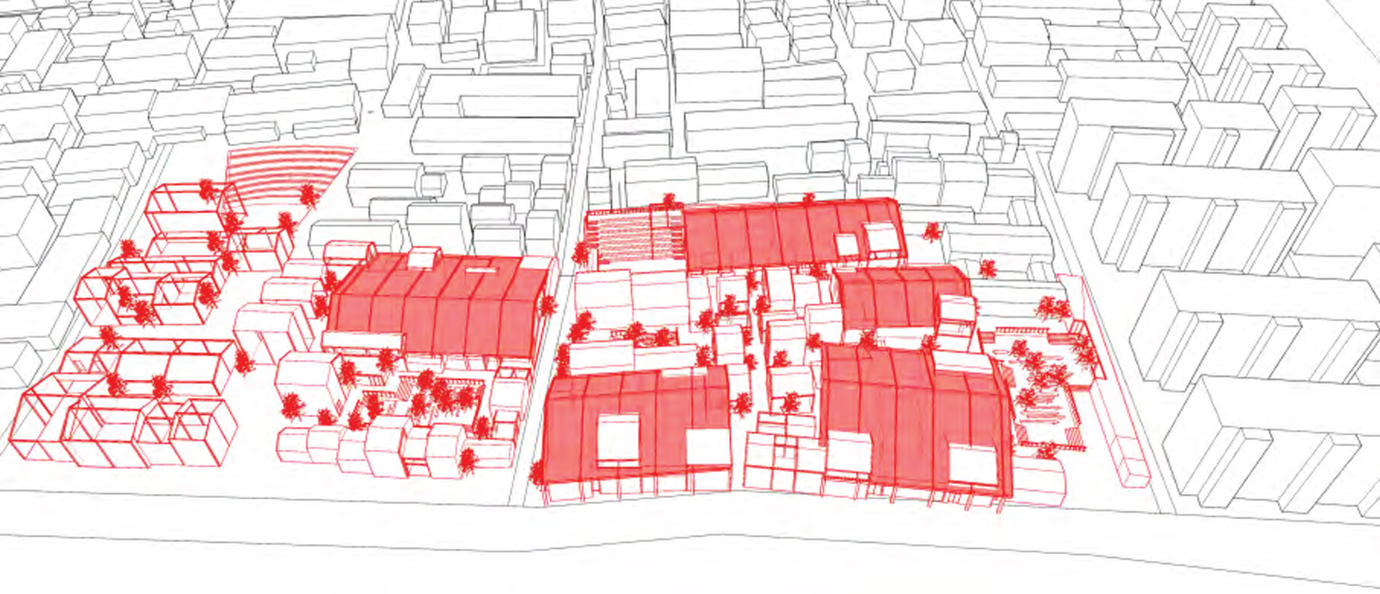
Overall planning of ancient villages based on big data.
Today, big data is impacting all aspects of people’s lives. How to make better use of data is the primary problem to be considered in the era of big data. From the perspective of data application, big data thinking can effectively use and mine data, so that data can be effectively recycled in the application process. During the outbreak of covid-19, staff were banned from all parts of the country. The design of sterol conversion is supported by big data. It improves the efficiency of reconstruction of ancient villages. The introduction of big data into rural planning is not only the driving force of the times, but also the working attribute requirements of rural planning itself. The data value mining and analysis of big data provides a more rapid and effective interpretation basis for the rural planning during the period of covid-19. However, due to the lack of understanding of the background of data, the mining of data value cannot be separated from the value orientation and application direction of artificial recognition. Therefore, whether it is data mining or machine learning with prediction as the main purpose, the intervention of artificial recognition is the key to the effective work of data, which requires the professional judgment and consideration of planning work and researchers in data recognition and value mining.
In the future, with the increasingly close communication and interaction between urban and rural areas, more value data will be introduced into rural planning to promote the development of urban-rural integration. How to integrate these data more quickly and apply them to more communication fields is an important topic of big data research in rural planning.
Footnotes
Acknowledgments
This paper is supported by Hubei Normal University Scientific Research innovation Team Project (No. 2019CP05).