
Abstract
Connectivity describes the degree to which matter and organisms can move among spatially defined units in a natural system. River connectivity is typically described in longitudinal, lateral, and vertical dimensions within the river corridor and the watershed and can be conceptualized as a continuum from fully connected to disconnected over diverse temporal and spatial scales. Explicit characterization of connectivity helps understanding of disparities among short-term, local rates of flux and inferred fluxes over larger scales. Connectivity also strongly influences the response of rivers to natural and human disturbances. Investigations of connectivity facilitate the recognition of processes that cross traditional disciplinary boundaries, as well as understanding of nonlinear behavior and retention within rivers. Enhancing the ability to identify, quantify, and predict the processes that create and maintain connectivity is integral to the effective management of rivers.
I. What is connectivity?
Explicitly recognizing that fluxes of matter and energy occur over diverse spatial and temporal scales is inherent in physical geography. Primary conceptual frameworks, such as the hydrologic cycle or the rock cycle, reflect this understanding. Investigators have been qualitatively and quantitatively describing matter and energy fluxes for more than a century (Davis, 1899; Gilbert, 1880), using different phrases to refer to the actual fluxes and the resulting characteristics of Earth surface processes and landforms. Analogously, decades of fluvial geomorphic research on sediment budgets and sediment delivery (e.g., Dietrich and Dunne, 1978; Walling and Collins, 2008) and hydrologic research on river flow and ground water source identification (e.g., Burns, 2002; Hooper and Shoemaker, 1986) inherently involve the identification and quantification of connectivity and disconnectivity, even though these words were not used in early papers.
Numerous definitions of connectivity have been published since circa 2000 (Table 1). The word passed from ecology and a primarily biological context (e.g., gene flow between subpopulations of a metapopulation; Merriam, 1984) to a hydrological context when Amoros and Roux (1988) described hydrological connectivity as the exchange of matter, energy, and biota between different elements of the riverine landscape via the aqueous medium. Stream ecologist James Ward, building on his conceptualization of rivers as four-dimensional entities (Ward, 1989), applied a connectivity framework to rivers in multiple papers (e.g., Ward, 1997; Ward et al., 2002). Other stream ecologists began to apply the word and its underlying ideas (e.g., Poole, 2002; Pringle, 2001) and geomorphologists picked up the term (e.g., Kondolf et al., 2006) and began to apply it more widely to describe water and sediment fluxes (e.g., Bracken and Croke, 2007; Brierley et al., 2006; Fryirs et al., 2007).
Definitions of connectivity relevant to the riverine process and form.

Here, connectivity refers to the degree to which matter (water, solutes, sediment, organic matter) and organisms can move among patches in a landscape or ecosystem. Patches in this context are arbitrarily defined areas that vary depending on the time and space scales under consideration. In a river, each pool and riffle could be a patch; each river segment between nodes formed by tributary confluences or dams could be a patch; or the channel, floodplain, and hyporheic zone within a river segment could each be a patch. The spatial dimensions of what is considered a natural system also vary in these three examples.
Movement of matter and organisms is commonly gradational. Small amounts of solutes move down a channel during base flow, for example, but the total solute flux can increase substantially during a flood. Consequently, connectivity can also be characterized as gradational, from fully disconnected to fully connected. Natural systems typically have differing degrees of connectivity that vary significantly across space and through time. This is reflected in the diverse scales of connectivity examined in recent papers addressing some aspect of river connectivity (Figure 1).

Time and space scales addressed in recent investigations of river connectivity. The primary distinction between the two plots is whether the investigation conceptualized connectivity primarily as a one-dimensional spatial flux, such as downstream within a river channel (a), or as a two-dimensional spatial flux, such as downstream and across a floodplain (b). Time and length scales. Blue indicates primarily hydrologic connectivity and brown primarily sediment connectivity. Key to numbers: (1) longitudinal hydrologic connectivity in channels (Jaeger and Olden, 2012); (2) longitudinal hydrologic and sediment connectivity in channels (Wohl et al., 2017); (3) longitudinal hydrologic and solute connectivity in river corridors (Wegener et al., in press); (4) vertical hydrologic connectivity in channels (Wainwright et al., 2011); (5) lateral, longitudinal, and vertical hydrologic connectivity in channels (Kondolf et al., 2006); 6) longitudinal sediment connectivity in channels (Czuba and Foufoula-Georgiou, 2015); (7) longitudinal hydrologic connectivity within channels (Tetzlaff et al., 2007); (8) longitudinal sediment connectivity along hillslope rills (Wester et al., 2014); (9) longitudinal sediment connectivity in channels (Souza et al., 2016); (10) longitudinal hydrologic connectivity in channels (Grill et al., 2014); (11) vertical hydrologic connectivity in riparian zones (Cadol and Wine, 2017); (12) longitudinal and vertical hydrologic connectivity in channels (Gooseff et al., 2017); (13) longitudinal sediment connectivity in channels (Gran and Czuba, 2017); (14) longitudinal sediment connectivity between hillslopes and channels (May et al., 2017); (15) longitudinal sediment connectivity in channels (Rice, 2017); (16) multiple forms of longitudinal connectivity in channels (Magilligan et al., 2016). Time and area scales. Blue indicates primarily hydrologic connectivity and brown primarily sediment connectivity. Key to numbers: (1) water and sediment connectivity between hillslopes and channels (Wainwright et al., 2011); (2) catchment sediment connectivity (Baartman et al., 2013); (3) longitudinal sediment disconnectivity in channels (Fryirs et al., 2007); (4) sediment connectivity between hillslopes and channels and within channel networks (Cavalli et al., 2013); (5) sediment connectivity within catchments (Micheletti et al., 2015); (6) hydrologic connectivity between channel and floodplain (Croke et al., 2013); (7) water and sediment connectivity in watersheds (Vanacker et al., 2005); (8) sediment connectivity in catchments (Heckmann and Schwanghart, 2013); (9) hydrologic connectivity in catchments (Jencso and McGlynn, 2011); (10) sediment connectivity in catchments (Coulthard and Van De Wiel, 2017); (11) hydrologic connectivity in abandoned channels on floodplains (Phillips, 2013).
Recent syntheses discuss specific forms of connectivity in much greater detail (e.g., Bracken et al., 2013, 2015) than this progress report, which briefly reviews geomorphic investigations of connectivity in rivers, from the scale of individual channel units to entire drainage networks. Although ecologists continue to make important contributions to our understanding of connectivity within rivers and fluxes of matter and organisms are intimately coupled, the focus here is on fluxes of matter (water, solutes, sediment) rather than organisms. I use the word river in the sense of a river corridor (Harvey and Gooseff, 2015), which includes the active channel(s), floodplain, and hyporheic zone.
II. Why does connectivity matter?
Explicit consideration of connectivity can facilitate the recognition of several important aspects of river process and form. Firstly, understanding the spatial and temporal scales of different types and degrees of connectivity can help to reconcile disparities between direct measurements of fluxes and inferred rates of landscape change. Secondly, connectivity strongly influences the resistance and resilience of rivers to natural and human-induced disturbances. Thirdly, conceptualizing rivers in the context of connectivity provides a useful framework for identifying processes that cross traditional disciplinary or research boundaries as well as spatial boundaries within landscapes. Fourthly, a connectivity framework is particularly useful for identifying the factors and processes that affect the retention or storage of diverse materials, including water, solutes, sediment, and organic matter. Fifthly, understanding connectivity provides critical insights into how nonlinear behaviors occur in rivers. Finally, identifying the factors that facilitate or limit connectivity is critical to effectively managing rivers.
2.1 Disparities in rates
Direct measurements of material fluxes have typically been conducted over relatively small spatial and short temporal scales. Extrapolating from direct measurements to larger scales can be problematic, however, particularly in the context of sediment movement. Schumm (1963) noted that contemporary rates of uplift are about eight times greater than contemporary rates of denudation, as inferred from measured sediment transport in rivers. Walling (1983) introduced the concept of the sediment delivery problem, in which only a fraction of the sediment eroded within a catchment will reach the basin outlet and be represented as sediment yield (Fryirs, 2013). Each investigator invoked sediment storage mechanisms to explain the discrepancy, and sediment storage can be viewed as a limitation on sediment connectivity. Kirchner et al. (2001) compared stream sediment fluxes directly measured over periods of 101 years to erosion rates derived from cosmogenic 10Be over timespans of 103 years and erosion rates from apatite fission tracks over periods of 106 years. The longer term estimates of sediment yields were on average 17 times greater than measured stream sediment fluxes. Kirchner et al. attributed these discrepancies to the episodic delivery of sediment from mountainous terrain. Even relatively short, annual to decadal records of sediment flux record temporal disparities in sediment movement, with much of the sediment flux occurring during a limited portion of the time interval being measured (Farnsworth and Milliman, 2003; Kao and Milliman, 2008). In a sense, sediment fluxes are fractal in time, with episodic fluxes characterizing a range of temporal and spatial scales. Understanding the processes by which sediment movement occurs and the factors that limit these processes (i.e., limit sediment connectivity), whether the limitations result from energy available to entrain sediment particles, supply of sediment to the river, or obstructions within the river, can illuminate the causes of episodic sediment fluxes (Bracken et al., 2015; Brierley et al., 2006; Fryirs, 2013). The apparent discrepancies in sediment delivery estimates over varying time scales and associated scaling issues continue to generate controversy (e.g., Parsons et al., 2006). However, the characteristics of sediment connectivity within drainage basins over diverse spatial and temporal scales can be a useful conceptual framework for understanding disparities in rates of sediment transport and storage.
2.2 River response to disturbance
Ecologists define a disturbance as any event that disrupts an ecosystem, community, or population structure and changes resources, substrate availability, or the physical environment (White and Pickett, 1985). Geomorphologists have tended to follow this definition (e.g., Butler, 2001; Montgomery, 1999). Natural disturbances in rivers typically result from abrupt and substantial changes in water and sediment supplied to the river corridor, such as during floods or debris flows. Human-induced disturbances can also be abrupt or can involve a sustained change associated with channel engineering or flow regulation. The resistance of a natural system describes how much the disturbance changes the system: a resistant bedrock channel might undergo little change in channel geometry or substrate characteristics as a result of a large flood. The resilience of a system, also referred to as sensitivity in the geomorphic literature (e.g., Fryirs, 2017), describes how quickly the system returns to pre-disturbance characteristics. A resilient alluvial channel might undergo substantial change in cross-sectional and bedform geometry during a large flood, but return to its pre-flood configuration within two or three years.
The resistance and resilience of a river both reflect connectivity during and after the disturbance. An anastomosing channel segment within a broad, vegetated floodplain may be resistant to change during a flood because the high flow spreads across the floodplain and dissipates energy. Energy dissipation occurs through overcoming hydraulic resistance caused by relatively shallow flow depths and high boundary roughness on the floodplain. In this example, the high lateral connectivity creates resistance. The broad alluvial floodplain can also have substantial hyporheic storage, which limits the longitudinal connectivity of water and reduces the erosional energy exerted by the peak flow against downstream river segments. In this case, high vertical connectivity and lower longitudinal connectivity create resistance. A laterally confined, gravel-bed, pool-riffle channel could be resilient to a flood because the excess sediment deposited during the flood is transported downstream within a few years by lower flows confined within the channel (Lisle, 1982). Here, high longitudinal connectivity creates resilience. In these and other cases, understanding the degree of connectivity during disturbances and intervening periods, as well as the factors that create or limit connectivity, can explain how a river responds to disturbances. Intertwined with this understanding is the realization that the alteration of sources of resistance or resilience can create substantial geomorphic change and alter the trajectory of adjustments within a river corridor (e.g., Brooks and Brierley, 2004; Brooks et al., 2003).
2.3 Crossing boundaries: River corridor science
Investigations of rivers have been mainly reductionist for nearly a century, partly out of a desire to develop a quantitative, mechanistic understanding of rivers and partly because a reductionist approach can facilitate isolating and manipulating individual variables. During this period, individual disciplines, such as stream ecology, fluvial geomorphology, aquatic biogeochemistry, and engineering hydrology, have emphasized specific aspects of rivers, sometimes treating these aspects in isolation. Explicitly focusing on connectivity can facilitate a more holistic understanding of rivers, as reflected in recent calls to think about riverscapes (Fausch et al., 2002) or river corridors (Harvey and Gooseff, 2015) rather than just river channels. Hyporheic zones, reciprocal terrestrial-aquatic subsidies, inundation hydrology, and segment-scale sediment budgets illustrate the centrality of connectivity in understanding river corridors.
Hyporheic exchange flows exemplify vertical connectivity within rivers and the relatively recent explosion of investigations devoted to this form of connectivity highlight the importance of vertical connectivity for water quality and river ecosystem sustainability (e.g., Acuña and Tockner, 2009; Gooseff, 2010; Tonina and Buffington, 2009). Reciprocal terrestrial-aquatic subsidies describe diverse exchanges among a channel, riparian zone, and upland environment. Examples include riparian plant litter, large wood, and insects that form an important part of river habitat and trophic systems (Livers and Wohl, 2016; Nakano and Murakami, 2001) and aquatic insects that emerge from the river and enter riparian trophic systems as food for riparian predators (Baxter et al., 2005). Hynes (1975) recognized these forms of lateral connectivity in a paper that is a classic of stream ecology and the recent use of isotopic tracers has further illuminated the fundamental importance of these exchanges within river corridors (England and Rosemond, 2004).
Vertical connectivity and lateral connectivity in other forms beyond main channel-floodplain connectivity can create differences in water quality, sediment dynamics, and flood hydrograph. Mertes (2000) introduced the phrase inundation hydrology, for example, to emphasize that the inundation of floodplains can occur before overbank flow on the main channel as a result of water inputs from other sources, such as a rising water table, overland flow, and overbank flows from tributaries.
Segment-scale sediment budgets from some floodplain rivers indicate that at least half of the sediment yield from a river segment can come from remobilization of floodplain sediment through lateral channel migration, rather than from transport of sediment originating upstream from the segment (Aalto et al., 2008; Dunne et al., 1998; Ham, 2005). In this example, lateral connectivity strongly influences longitudinal sediment flux.
One implication of these diverse examples is that what seems to be the most obvious form of connectivity in any given system – downstream flow of water in a channel, consumption of aquatic insects by fish, overbank flow during a flood, or longitudinally continuous sediment transport within a channel – may not be the only or even the most important aspect of connectivity within the river.
2.4 Retention in rivers
Retention here refers to storage of material over varying time scales, from a few minutes to tens of thousands of years or more, depending on the example under consideration. Although there are scenarios in which retention within a river is not desirable, such as retention of pollutants adsorbed to fine sediment, in many cases retention is a benefit. Retention fundamentally reflects some limit on longitudinal connectivity and fluxes of water, sediment, solutes, and organic matter. Consequently, explicit focus on the processes underlying connectivity can facilitate understanding and enhancing retention in rivers. River corridors that retain water within hyporheic zones or floodplains can attenuate flood peak flow and sustain base flow during dry periods (Lininger and Latrubesse, 2016; Wegener et al., in press). The retention of nitrates or dissolved organic carbon within hyporheic zones, riparian forests, or floodplain wetlands can improve water quality if these portions of the river corridor contain microbial communities capable of processing the nitrates and carbon (Zarnetske et al., 2011). River corridors that retain particulate organic matter can support greater biomass and biodiversity (Beckman and Wohl, 2014; Jones and Smock, 1991). Because of these benefits, much effort is now devoted to restoring retention within river corridors that has been lost through river engineering, such as channelization or levee construction (Palmer et al., 2005; Wohl et al., 2015b).
2.5 Nonlinear behavior
Nonlinear behavior occurs when outputs or responses are not proportional to inputs or stimuli (Boeing, 2016). Nonlinear behavior includes system changes that occur without external forcing; patterns that emerge spontaneously; asynchronous and contrasting responses within a system; and the presence of thresholds and feedbacks (Favis-Mortlock, 2013; Phillips, 2003). Spatial and temporal variations in connectivity are responsible for at least some of these forms of nonlinear behavior, as illustrated by intrinsic thresholds in channel incision and emergence (Harrison et al., 2006) in the formation of anastomosing planform.
Field studies indicate that ephemeral channels can switch from aggrading to incising without a change in external variables, such as water and sediment inputs or relative base level (Schumm and Hadley, 1957). The change in channel behavior results from episodic longitudinal disconnectivity in water and sediment fluxes as surface flow infiltrates into the alluvial bed in dryland rivers, depositing sediment on the bed and creating locally oversteepened reaches at which headcuts subsequently form. In the case of anastomosing planform, channel-spanning logjams can facilitate overbank flow that leads to the formation of multiple, subparallel channels (Davies and Gibling, 2011; Wohl, 2011) where variations in river corridor geometry create longitudinal disconnectivity in the transport of large wood (Wohl and Cadol, 2011). Bank erosion within the multiple channels recruits additional wood for logjam formation and large logjams create erosionally resistant units that persist within the floodplain as channels migrate laterally (Collins et al., 2012). The simple interactions involved in wood recruitment and logjam formation result in an emergent, persistent channel planform. In these and other examples, temporal and spatial variations in connectivity create instabilities and feedbacks that manifest as nonlinear behavior.
2.6 River management
Connectivity is strongly influenced by spatial and temporal heterogeneity in river corridors (Burchsted et al., 2010; Wohl, 2016). The cumulative effect of diverse forms of river engineering and anthropogenic watershed alteration has been to reduce the spatial heterogeneity of rivers (Peipoch et al., 2015) and to reduce the temporal heterogeneity associated with water and sediment fluxes (Poff et al., 2007). This has altered connectivity, although the details vary. Infrastructure, such as levees and dams, reduces lateral and longitudinal connectivity, respectively, whereas channelization can increase longitudinal connectivity but decrease lateral and vertical connectivity.
As river management increasingly seeks to restore lost functions, such as retention and habitat abundance and diversity, processes of and controls on connectivity become critical (Jansson et al., 2007). Traditional design and operation of bridges (USBR and ERDC, 2016), culverts (Blakely et al., 2006; Park et al., 2008), levees (Galat et al., 1998), and dams (Olden and Naiman, 2010) are being modified to restore reduced connectivity and to facilitate the dispersal of organisms and fluxes of water and sediment that create and maintain habitat. Strategies are being developed to limit connectivity where connectivity has been artificially increased by altered flow regime (Hassan and Egozi, 2001), water transfers have allowed dispersal of invasive organisms (Waters et al., 2002), or riparian vegetation has been removed (Amoros and Bornette, 2002). Fundamentally, connectivity can provide a conceptual framework for understanding how human activities have modified river corridors, as well as how to mitigate the negative consequences of these modifications (Croke et al., 2017; Kondolf et al., 2006).
III. Measures of connectivity
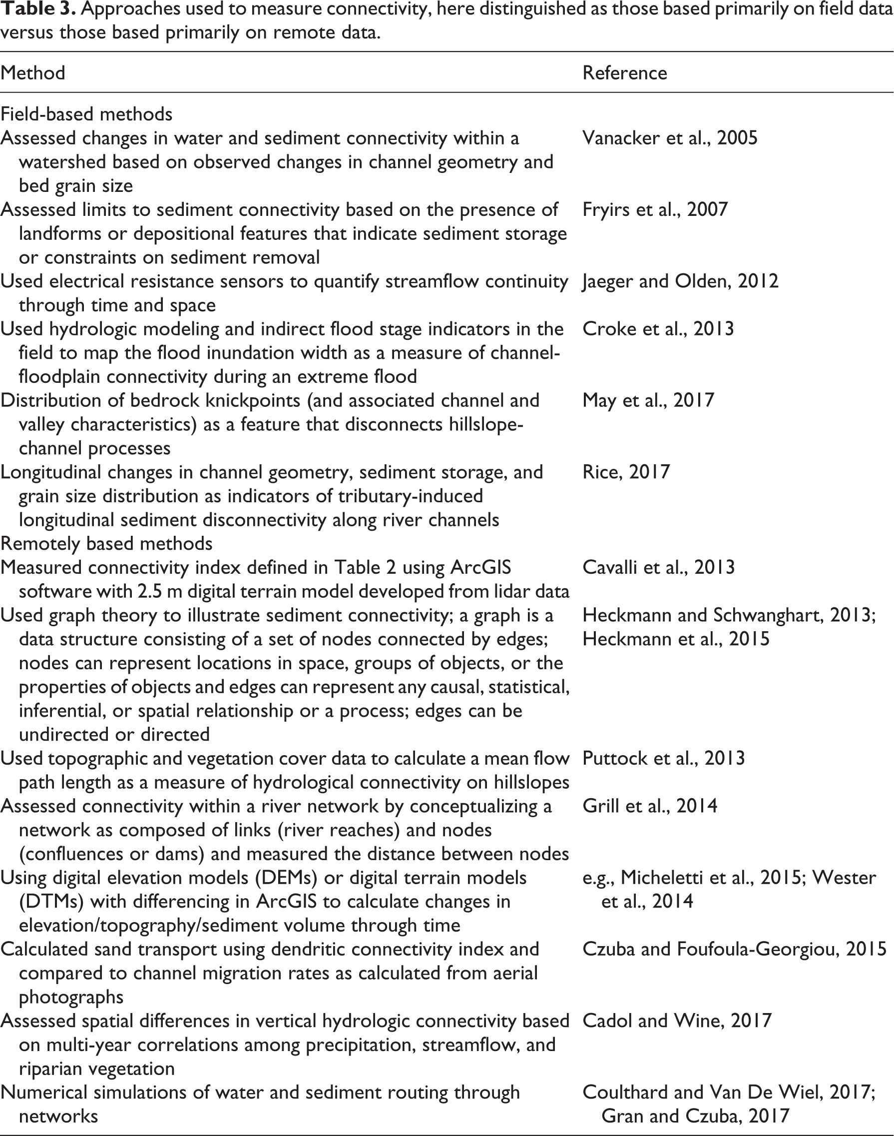
Diverse measures of connectivity have been applied to investigating fluxes of different materials across varying spatial and temporal scales (Table 2). Qualitative approaches typically evaluate relative differences in, for example, the volume of sediment storage or landform change over some time interval (e.g., Cadol and Wine, 2017; Fryirs et al., 2007). Quantitative approaches measure fluxes through time and space or the result of these fluxes in terms of landform change (e.g., Micheletti et al., 2015) (Table 3). During the past few years, an increasing number of studies have developed numerical simulations of fluxes and then compared the predictions from these numerical models to real-world measurements obtained from field studies or remotely sensed data (e.g., Cavalli et al., 2013; Gran and Czuba, 2017). The use of qualitative versus quantitative measures and the specific aspects of connectivity that are measured reflect the objectives of individual studies or management applications. Limited direct measurements can constrain the ability to quantify some aspects of connectivity, although the increasing availability of remotely sensed data is enhancing our ability to quantify connectivity across large spatial scales and through time (e.g., Konrad et al., 2008; Loheide and Gorelick, 2006).
Examples of metrics of connectivity.

Approaches used to measure connectivity, here distinguished as those based primarily on field data versus those based primarily on remote data.
IV. Where next?
As river scientists continue to develop and apply ideas of connectivity to river corridors, the primary remaining issues include the following: identifying relevant time and space scales of connectivity in different contexts; quantifying and predicting connectivity; and restoring desired levels of connectivity. Each of these issues involves basic and applied science.
4.1 Relevant scales of connectivity
With increasing emphasis on connectivity, there is the danger that river management, in particular, may overly simplify connectivity under the assumption that increased connectivity is always good. Natural river corridors include numerous forms of at least temporary or local disconnectivity that enhance channel stability, attenuate hydrologic extremes, retain material moving down the river network, and enhance the dispersal of organisms (e.g., Burchsted et al., 2010; Poole, 2002). The key point is to identify natural or desired levels of connectivity within any particular river, as well as the mechanisms that create and maintain those levels of connectivity (Fryirs and Brierley, 2009). This is not necessarily straightforward. Water (Poff et al., 1997), sediment (Wohl et al., 2015a), and nutrient regimes (Dodds, 2007) vitally influence the sustainability of river ecosystems. In the same river, constraints on connectivity during large flows may limit sediment flux, whereas constraints on longitudinal hydrologic and nutrient connectivity during base flow or droughts may limit those fluxes. Because a river corridor is a multidimensional, multivariable, nonlinear system, identifying all relevant aspects of connectivity presents a significant challenge.
4.2 Quantifying and predicting connectivity
Many aspects of connectivity are intuitively obvious once they are identified: of course, tributary fans represent sediment storage sites that limit lateral and longitudinal sediment connectivity (e.g., Fryirs et al., 2007) and, of course, aquatic insects emerging from the stream are preyed on by riparian birds, creating lateral connectivity between streams and riparian zones (e.g., Baxter et al., 2005). The challenge lies in quantifying such relationships and being able to use quantitative understanding to predict how the river corridor will react to disturbances or management (e.g., Shafroth et al., 2010). How will quantities, grain size distribution, mode of transport, duration, frequency, and travel length of sediment increase if an alluvial fan is altered by construction? How will riparian predators respond if an introduced species of fish alters the emergence of aquatic insects (Baxter et al., 2004)? Developing this level of knowledge and predictive ability is likely to remain a major challenge for many years, yet is crucial to managing river corridors to achieve the desired conditions.
4.3 Managing connectivity
Given that restoring natural or desired levels of connectivity is increasingly a goal of river management, the quantitative predictive ability discussed above is likely to be critically important. In this context, natural levels of connectivity may not be as relevant as threshold levels of connectivity to restore desired effects. Bernhardt and Palmer (2011), for example, question the fuzzy logic of restoring limited sections of river in order to reverse catchment-scale degradation, but just how much does lateral connectivity between uplands and channels need to be limited by restored riparian vegetation, for example, in order to achieve targeted levels of nitrate retention and uptake? Bernhardt and Palmer (2011) also note the importance of considering upland-scale management that influences fluxes to the river corridor, particularly in urban settings where increased impervious areas (Walsh and Kunapo, 2009) and engineering, such as stormwater drainage and channelization, have created hyper-connectivity within channel networks (Walsh et al., 2016). The inclusion of upland land management reflects the recognition that connectivity outside of the river corridor (e.g., uplands-river corridor, atmosphere-river corridor, ground water-river corridor) can strongly influence river corridor functioning.
Effectively balancing human consumptive and other demands on rivers against restoration of connectivity requires a relatively high level of understanding of what management is trying to achieve (Blue and Brierley, 2016), how a particular area targeted for restoration is situated within a larger river catchment (Brierley and Fryirs, 2009, 2016; Fryirs et al., 2009), and what types and magnitudes of connectivity are critical to river function. The latter point includes distinguishing beneficial and detrimental connectivity. Beneficial connectivity can be defined as connectivity that creates a desired process or characteristic within a river corridor, whereas detrimental connectivity creates an undesirable process or characteristic. The designation of a particular form of connectivity as beneficial or detrimental may well be inconsistent between stakeholders. An engineer concerned primarily with reducing overbank flooding will view increased channel conveyance and longitudinal connectivity as beneficial, for example, whereas an ecologist concerned primarily with preventing the upstream migration of an introduced aquatic species may consider increased longitudinal connectivity in the same river corridor to be detrimental.
The development of predictive numerical models relevant to the processes or features (e.g., habitat) influenced by connectivity is necessary for effective, integrated river management in the future. As we move toward this goal, more qualitative, observational-based connectivity analyses have already made a difference in how we perceive and manage river corridors, as illustrated by river restoration projects explicitly designed to restore some aspect of connectivity (e.g., Tockner et al., 1998; Woolsey et al., 2007). Continuing improvements in our ability to quantify and numerically model connectivity will likely improve our ability to predict river responses to specific disturbances or management activities. This is exemplified by investigations of sediment connectivity in the Colorado River within the Grand Canyon, where more than a decade of hydrologic and sediment measurements have been used to progressively refine sediment budgets that inform experimental flow releases designed to restore river ecosystem functions (Melis, 2011). Although the substantial effort, time, and cost involved in this intensive investigation of sediment connectivity will not be feasible in many river-management contexts, the conceptual framework of connectivity can provide relevant insights for most aspects of river management.
Footnotes
Declaration of conflicting interests
The authors declared no potential conflicts of interest with respect to the research, authorship, and/or publication of this article.
Funding
The authors received no financial support for the research, authorship, and/or publication of this article.