
Abstract
Physical geographer Konrad “Koni” Steffen, lost 8 August 2020 in a crevasse on the Greenland ice sheet, was a pioneer in satellite remote sensing and field observations of the Greenland ice sheet. This Classics Revisited piece honors the memory of Koni Steffen and examines the impact of a work which laid the foundation for numerous studies that made the Greenland ice sheet and the man global icons of climate change.
I Introduction
Today even more relevant than 28 years ago, the title of this article, “Climate sensitivity studies of the Greenland ice sheet using satellite AVHRR, SMMR, SSM/I and in situ data,” nicely encapsulates the broad impact of the authors’ climate research in: pioneering the use of satellite remote sensing in cryosphere studies; exploiting distinctly different regions of the electromagnetic spectrum; relying on hard-won Arctic ground-truth observations; and emphasizing the utility of the Greenland ice sheet as a climate sensitivity laboratory. The work typifies the lead author Konrad “Koni” Steffen’s vision, talent in conjuring resources, and physical and mental strength.
II Koni Steffen
With numerous international chairmanships and center directorships, ultimately as director general of the Swiss Federal Institute for Forest, Snow and Landscape Research (WSL), Koni (Figure 1) had a very full and impactful career. His scientific work began with studies of Swiss glaciers and the glaciers of Axel Heiberg Island, Canada including the North Water Polynya, 1975–1984. His PhD was based on in situ observations obtained from twice overwintering in the Canadian High Arctic and Greenland (1979/80 and 1980/81) to investigate the surface conditions of the North Water from aircraft and surface automatic weather station observations. The North Water Polynya is an anomalous open water area forming in winter from wind and/or upwelling warm water, and it is a wildlife bonanza, an area of strong atmospheric heat release, and a ‘sea ice factory’. During the aircraft campaigns, Koni was aboard a low-flying (150 m altitude) De Havilland Dash-6 “Twin Otter,” measuring the polynya surface temperature and albedo, 1 accompanied by high-resolution photography—another passion of his. His work gained further international dimension and momentum between 1986 and 1988 with a two-year visiting fellowship at the Cooperative Institute for Research in Environmental Sciences (CIRES) of the University of Colorado (CU), Boulder, where his attention turned to the Greenland ice sheet. He carried forward work from his native Swiss Federal Institute of Technology (ETH) camp on the western ice sheet, a place that became affectionately known as “Swiss Camp.” This camp was located in an important altitude known as the equilibrium line, where winter snow accumulation and summer melt balance. Changes in the location of the equilibrium line altitude provide important insights into how the mass balance of the Greenland ice sheet is changing in response to climate, with important implications for global sea level rise.

Koni Steffen. Photo ETH, Zurich.
Relying on ground truth observations
Here, the reviewed article and Koni’s scientific work in general would not have had a solid foundation without interpreting the remotely sensed observations that are key to upscaling point observations at the surface. The prospect for ground observations was greatly enhanced by Koni’s vision to sustain Swiss Camp (Figure 2). As Steffen et al. (1993) wrote: “Scientists from the Swiss Federal Institute of Technology (ETH) in Zürich established a permanent research camp at the equilibrium line of the Greenland ice sheet near Jakobshavn (69° 34’ N, 49° 17’ W) [at equilibrium-line altitude
2
] in spring of 1990. The research station has been transferred in summer 1992 to the University of Colorado at Boulder to continue the field experiments for three additional seasons.”
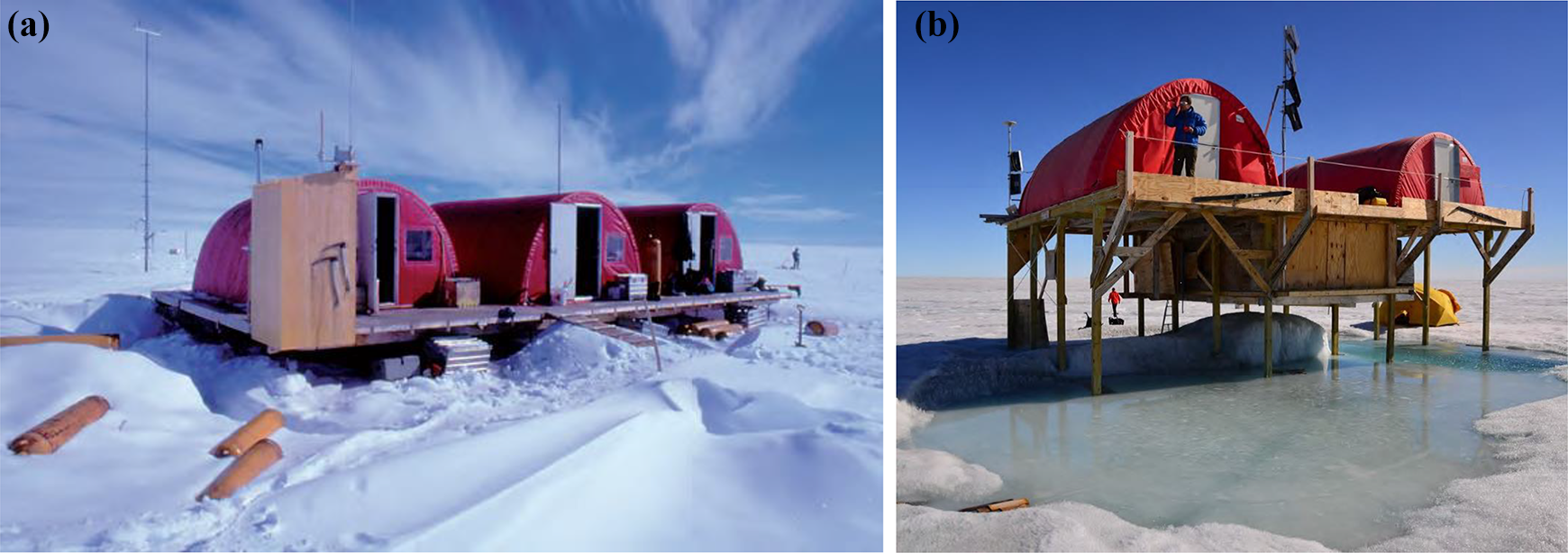
(a) Swiss Camp 1991, western Greenland ice sheet. Photo Manfred Stober. (b) A rebuilt Swiss Camp, summer 2016, after the 12 m of ice melt that accompanied the local in situ measurements of summer (June through August) when average warming by 1.3 °C had caused the camp to melt out and fall over twice (in 2010 and 2012). Rather than pack up and remove the collapsed stations, Steffen managed to keep Swiss Camp, a perennial research base, running for 30 years, until the point when he was handing over the running of the Greenland Climate Network (GC-Net) to the geological survey of Denmark and Greenland 3 and where he had his tragic and mortal fall into a water-based crevasse. 4 Photo Konrad Steffen.
In an email to a Washington Post reporter, Waleed Abdalati later reflected: “dating back to my PhD work in the mid 1990s, the satellite-based melt algorithm I developed to quantify the spatial extent and duration of melt on Greenland relied on validation on the ground from Koni’s weather stations to determine when melt started and when it ended each year. Once validated, we were able to trust that the algorithm accurately captured surface melt and as a result, we were able to reliably track the evolution of that melt on the ice sheet in both space and time, seeing things like the increasing melt trend in space and time.”
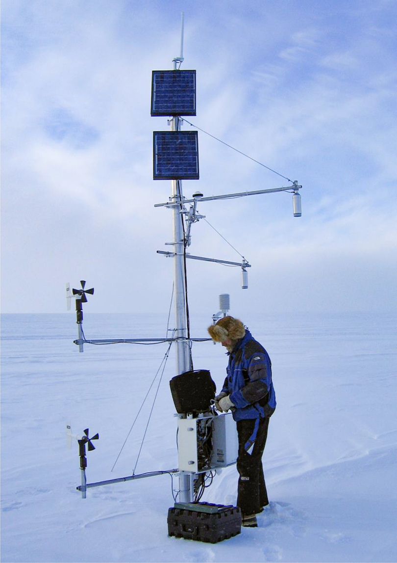
Koni Steffen gathering data from one of the Greenland Climate Network (GC-Net) stations in May, 2005. Photo J. Box.
Considering Koni’s vision, it’s important to recall now just how different our perspective on cryospheric climate change was in the early 1990s. Approaching three decades ago, Steffen et al. (1993) wrote: “Trends for the annual temperature computed from land surface stations for the period 1961 to 1990 show a slight cooling for the southern half of Greenland…computer model simulations of the greenhouse scenario predict a regional cooling for the Greenland ice sheet, contrary to the general warming trend over the Arctic sea ice areas…However, our present knowledge of the mass and energy exchange, and its sensitivity to environmental conditions, is insufficient to make reliable quantitative estimates of future changes associated with the greenhouse warming.”
III Pioneering the use of satellite remote sensing in cryosphere studies
Given that NASA’s 1989 Mission to Planet Earth had yet to bear the needed multiyear records for climatological analyses, Steffen et al. (1993) instead exploited operational satellite missions that were designed not for climatological timescales but rather to serve day-to-day weather monitoring and forecasting. Thus, the work introduced the need for the intercalibration of multiple satellite missions and taking on the challenge of handling heavy datasets. The latter challenge was especially true for the relatively high resolution Advanced Very High Resolution Radiometer (AVHRR) visible data. Co-author Julienne Stroeve spent countless hours in raw data handling. I recall that, on days she worked at home with a new baby, she would occasionally ring our office at CIRES with a request to swap tapes. The work, we are reminded, took place at a time when the Internet itself was fledgling and data centers still mailed CD-ROMs, and scientists paid premiums prices for high-capacity storage hardware.
The study introduced atmosphere correction work for optical wavelengths, enabling surface retrievals from the top of the atmosphere. In addition to estimations of surface temperature climatology for the ice sheet (Stroeve and Steffen, 1998) and defining a key algorithm for retrieving snow and ice absorption of sunlight (Klein and Stroeve, 2002), that work would culminate in the first rigorous climatology of Greenland albedo (Stroeve, 2001), finding a distinct climate sensitivity for the large amounts of sunlight the ice sheet absorbs, especially when melting. Stroeve’s work set the stage for numerous subsequent evaluations of Greenland snow and ice albedo changes (e.g. Tedesco et al., 2011; Box et al., 2012; Peng et al., 2018) with the advantages of advanced sensors, better image geolocation, higher spatial and spectral resolution, and the ease of much greater and less costly data storage.
To a vastly different part of the spectrum, where the Earth radiates in microwave frequencies and in a part of the spectrum that is far less given to clouds, Steffen et al. (1993) exploited the SMMR and SSM/I passive microwave sensors. These were launched for the United States’ defense department’s operational meteorology and, like the AVHRR, not designed for ice sheet climate studies. Here, by comparing the passive microwave radiances with automatic weather station data, they found a promising classifier for the distinction between dry and wet snow. The work introduced, in parallel to Mote et al. (1993), what became a microwave melt classification for the Greenland ice sheet that co-author Waleed Abdalati would subsequently calibrate using field data to map daily surface melt extent across Greenland. This in situ validation—only made possible by the accessibility of the “Swiss Camp” and its integration with space-based observations—ensured that the algorithm was sufficiently robust that it could be credibly examined in the context of climatological and meteorological conditions. The results showed ice sheet melt had very clear linkages to climate change, the North Atlantic Oscillation, and major volcanic eruptions (Abdalati and Steffen, 1995, 1997). And so, in addition to well-known mapping changing polar sea ice extent (Cavalieri et al., 1997), a primary legacy of passive microwave remote sensing has been daily mapping of the melt area of the Greenland ice sheet. Near-real-time Greenland melt maps are now posted online automatically 7 and a global audience is kept informed in annual “state of the climate” reports (NOAA’s Arctic Report Card).
Later works cited this study in mapping Antarctic surface melting (Torinesi et al., 2003; Liu et al., 2006). More recent citations to the article include examination of Antarctic ice sheet melting in its climate teleconnection with the Atlantic multidecadal oscillation (Liang et al., 2019) or again for Antarctica, taking forward its spirit in merging multifrequency melt retrievals (Zheng et al., 2019), and for Greenland.
IV Utility of the Greenland ice sheet as a climate sensitivity laboratory
The article demonstrated the feasibility of satellite remote sensing as a technique for climate studies over extensive and homogeneous snow- and ice-covered areas. The extensive Greenland ice sheet was showcased as an excellent target for validation of satellite remote sensing, being overlain by a relatively cloud-free atmosphere with low atmospheric moisture content making the compensation of the atmosphere in surface retrievals less demanding than for practically anywhere else in the Arctic, if not the world.
Koni understood the importance of how the varying reflectivity of snow and ice was a key modulator in cryosphere climate sensitivity. The presence of snow and ice or the lack thereof determines a wide margin of absorbed sunlight, forming one of the strongest amplifiers of anthropogenic climate change. Yet, accurately retrieving snow and ice properties from space is elusive, requiring ground truth observations that Koni was talented in conjuring.
V Conclusion
This still well-cited article 8 clearly mapped what would become a broad and high impact enterprise of the then-graduate-student co-authors. The work introduced how satellite remote sensing offers the very powerful ability to observe vast inhospitable areas from the comfort of the office. Lead author Koni Steffen would instead take the challenge to make annual expeditions, to bring his graduate students and “ground truth” to bear on several lofty approaches in remote sensing. The ground truth enabled much more confident upscaling of the satellite data to full ice sheet mapping. In that sense, Koni understood that field observations alone did not provide the coverage necessary to draw robust conclusions about the state of change and the large-scale processes at work. He also understood that, while satellite observations provided the spatial coverage needed, they required comparisons to surface-based observations to be credible and appropriately interpreted. His marriage of the two was both insightful and groundbreaking. The work set a high standard for bringing field observations to bear in climate sensitivity process-studies.
The work also set the stage for communicating hard won field-based findings with the world in what would become a prophetic diagnosis of climate change.
Footnotes
Acknowledgements
Support from the United States National Aeronautics and Space Administration (NASA) in cryosphere climate studies was of great value in illuminating climate change through work such as that of Steffen and his numerous graduate students. Atsumu Ohmura provided helpful details of Koni’s career through his International Glaciological Society obituary. 9 Nel Caine is thanked for suggesting the study.
Declaration of conflicting interests
The author(s) declared no potential conflicts of interest with respect to the research, authorship, and/or publication of this article.
Funding
The author(s) received no financial support for the research, authorship, and/or publication of this article.