
Abstract
Age-controlled pollen and microcharcoal records from Holocene sediments in Paju Unjeong, Korea, reflect the response of vegetation dynamics to climate changes and human activity. The pollen spectrum shows clear differences between the natural vegetation stage and the land-use vegetation stage. The land-use vegetation stage is further divided into dry-field cultivation and paddy-field cultivation stages. The natural vegetation stage (c. 8420–4700 cal. BP, early Neolithic) indicates the presence of dense woodlands consisting of various deciduous broadleaved trees on well-drained hills to uplands during the mid-Holocene period. Early Neolithic foraging peoples occupied the area and collected wild plants and fruits, such as acorns. The land-use stage (c. 4700 cal. BP, late Neolithic to Modern) reflects forest transition and, finally, Gramineae-dominated open landscape. During the dry-field cultivation stage (c. 4700–2000 cal. BP, late Neolithic to Bronze Age), inhabitants may have used fire as the principal means to open lowland vegetation for occupation, wood reclamation, and artifact making. During the paddy-field cultivation stage (c. 2000 cal. BP, Iron Age to Modern), inhabitants’ activities on adjacent open lowland increased. The local area became an extensive open landscape on which the Baekje people (c.
Introduction
The development of agriculture in Korea, as elsewhere, was an important part of land-use regimes and Holocene human adaptation. Korean archaeology can help to clarify the mechanisms involved. Prehistoric activities evidenced by artifacts and paleoethnobotany have been archaeologically documented in the context of agricultural cultivation and ground burned off for expanding dry fields in Korea (Ahn, 1997, 2008, 2010; Crawford and Lee, 2003; Kim and Yun, 2010).
In the last three decades, pollen analyses in South Korea have been carried out to reconstruct the history of natural vegetation responses to climate changes (e.g. Chang and Kim, 1982; Chang et al., 1987; Chung et al., 2006, 2010; Jun et al., 2010; Yi and Kim, 2010; Yi et al., 2004, 2005, 2008a, b; Yoon, 1997, 2011). However, until now, only a few pollen studies with emphasis on paddy- and dry-field farming based on cultivated plant and synanthropogenic habitats have been reported from organic-rich sediments in wetlands in lowland areas (e.g. Yasuda et al., 1980; Yi and Kang, 2009; Yoon et al., 2005). Furthermore, no pollen studies examining human disturbances on woodlands have been reported thus far.
Pollen records analyzed from the Paju Unjeong area, which is geomorphologically represented by low hills, have shown drastic changes in pine and oak trees from the Neolithic to the Bronze Ages. The pollen profile showed that the relative frequencies of those two pollen grains did not coincide with climate changes. Oak trees have been used as firewood to cook food and create warmth in Korean underfloor heating systems, a technique still used today in traditional Korean houses. Conifer, especially red pine (Pinus densiflora), was a principal architectural material traditionally used to build houses through much of Korea’s history.
Therefore, the pollen frequencies of these two trees (pine and oak) can be potential indicators of woodland disturbances and possible land use in prehistoric times in South Korea. This study interprets the relationship between woodland vegetation changes and human disturbances in Paju Unjeong area.
Study area
The study area belongs, as an administrative district, to Gyoha-eup, Paju-shi, Gyeonggi Province. This area, near a lower reach of the Han River, is located in the lower part of low hills. The Han River is 6 km south of the study area; it flows northwest to Goyang-shi and then meanders northward, flowing into the Yellow Sea. The topography of the study area includes a relatively flat alluvial plain and a small area of low hills in the south; the rest of the area is somewhat mountainous. The flat alluvial plain, with an elevation of less than 40 m above sea level (a.s.l.), is now used as paddy fields, whereas the mountainous area, with an elevation of up to 60 m a.s.l. in the north, is now occupied by forests and residential areas (Figure 1A).
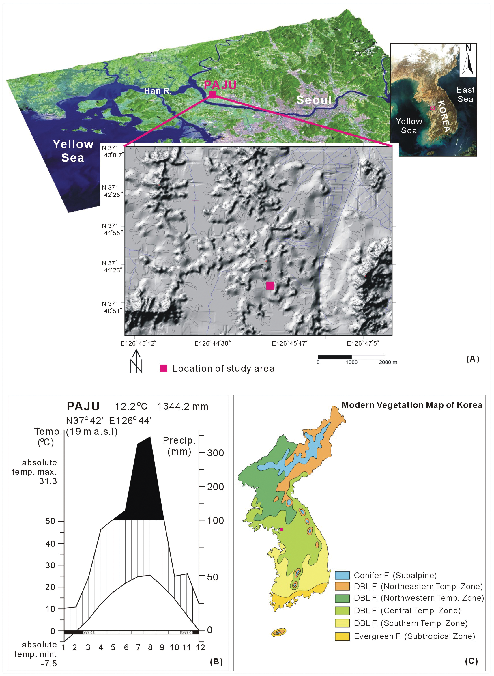
(A) Landsat imagery of the lower reach of the Han River (upper) and shaded relief map showing the geomorphological features. The red square marks the study area in the Paju Unjeong area. (B) Seasonal changes in temperature and precipitation in the Gangwhado-Seoul area based on information from the Korea Meteorological Administration (http://kma.go.kr). (C) Modern vegetation map (modified from Yim and Kira, 1975)
Undisturbed sediment of core UJ-10 was obtained in 2007 in the lower part of the low hills (129°56′1.34″E, 35°03′29.43″N), with elevations of 18.7 to 19.3 m a.s.l. The basement rock consisted of a banded gneiss unconformably underlain by alluvium (Lee and Kim, 1992).
Because Paju is located between the Gwanghwa and Seoul Meteorological Stations, I used data from both sites. At present, the Paju area experiences a cool-temperate climate. Between 1971 and 2000, the area was characterized by a mean annual temperature of 10.9–12.2°C, with temperatures ranging from a high of 16.1–25.9°C in August to a low of 6°C to −3.0°C in January (Korea Meteorological Administration, http://www.kma.go.kr). Precipitation is relatively high (mean, 1316.7–1344.3 mm/yr), and about 66.9% to 71.6% of the annual precipitation falls in summer, especially from June to August (Figure 1B).
Today, vegetation of the Paju Unjeong area, which belongs to the central temperate zone of the deciduous broadleaved forest (Yim and Kira, 1975) (Figure 1C), is composed of, by elevation, a Quercus mongolica community, a Q. variabilis–Q. mongolica community, and a Q. mongolica–Q. variabilis community. Furthermore, the study area is characterized by a Q. mongolica community consisting of hardwood trees of Q. mongolica, Q. variabilis, Q. aliena, Q. acutissima, Rhus trichocarpa, Prunus sargentii, Acer palmatum, Zelkova serrata, Celtis sinensis, Corylus heterophylla, Magnolia sieboldii, and Alnus japonica; shrubs of Fraxinus rhynchophylla, Styrax japonica, Lindera obtusiloba, Rhododendron schlippenbachii, Symplocos chinensis for. pilosa, and Juniperus rigida; and herbs of Artemisia keiskeana, Athyrium yokoscense, Dioscorea japonica, and Lactuca raddeana (Choi, 1988; Jeong and Yang, 1999).
Materials and methods
The study profile is approximately 160 cm thick and is divided into seven lithological horizons composed of three distinctive sedimentary units: Unit 1, dark greenish-gray sand with angular pebbles in the upper horizon and grayish-brown sand and granules in the lower horizon (elevation, 17.904–17.144 m a.s.l.); Unit 2, dark gray, coarse sand with some rounded and some angular pebbles in the low horizon (elevation, 18.414–17.904 m a.s.l.); and Unit 3, overlying monotonous dark gray soil (elevation, 18.764–18.414 m a.s.l.) (Figure 2).
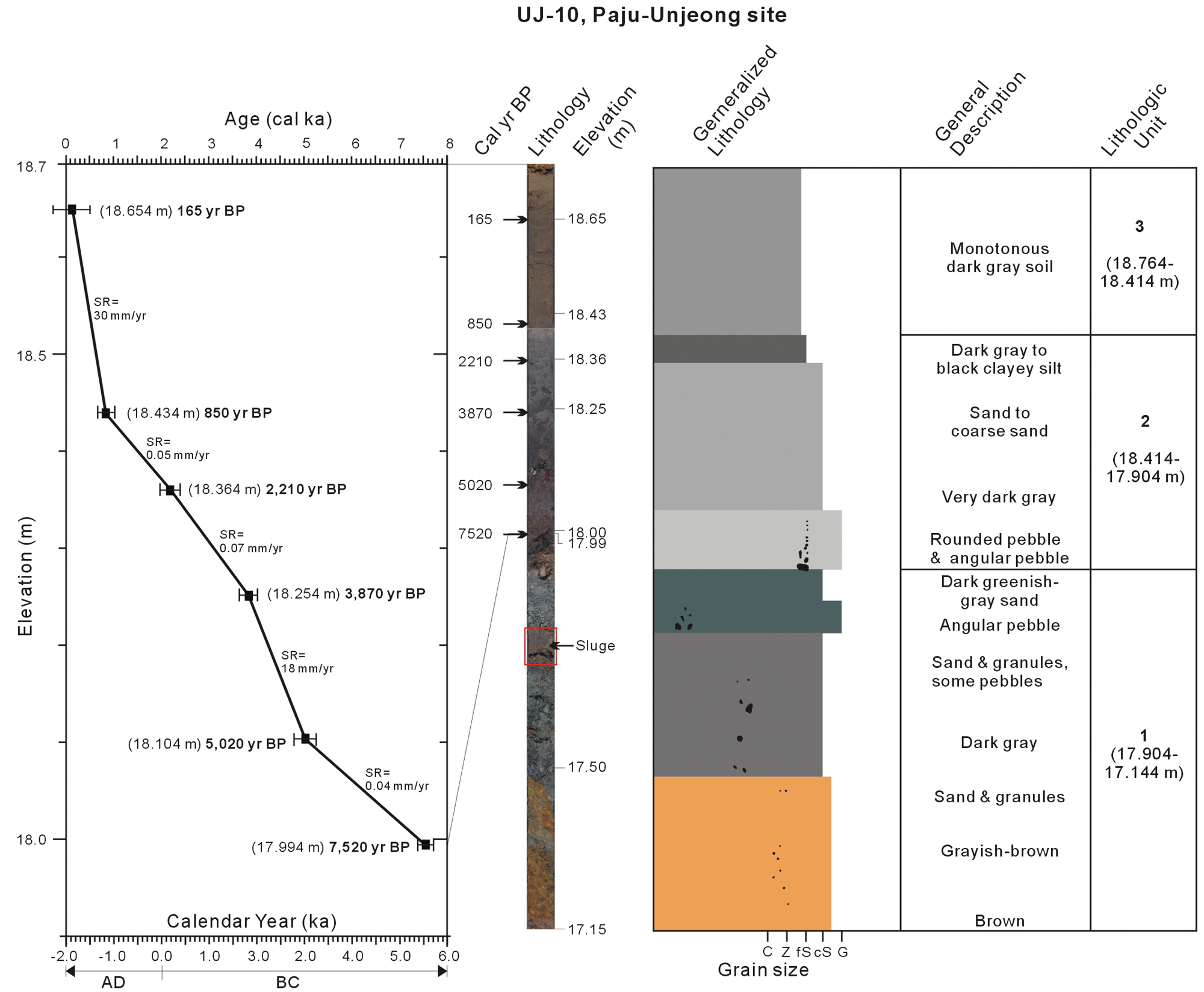
Photo of the core with corresponding depth, calibrated age, elevation, and lithologic characteristics. C, clay; Z, silt; fS, fine sand; cS, coarse sand; G, granule
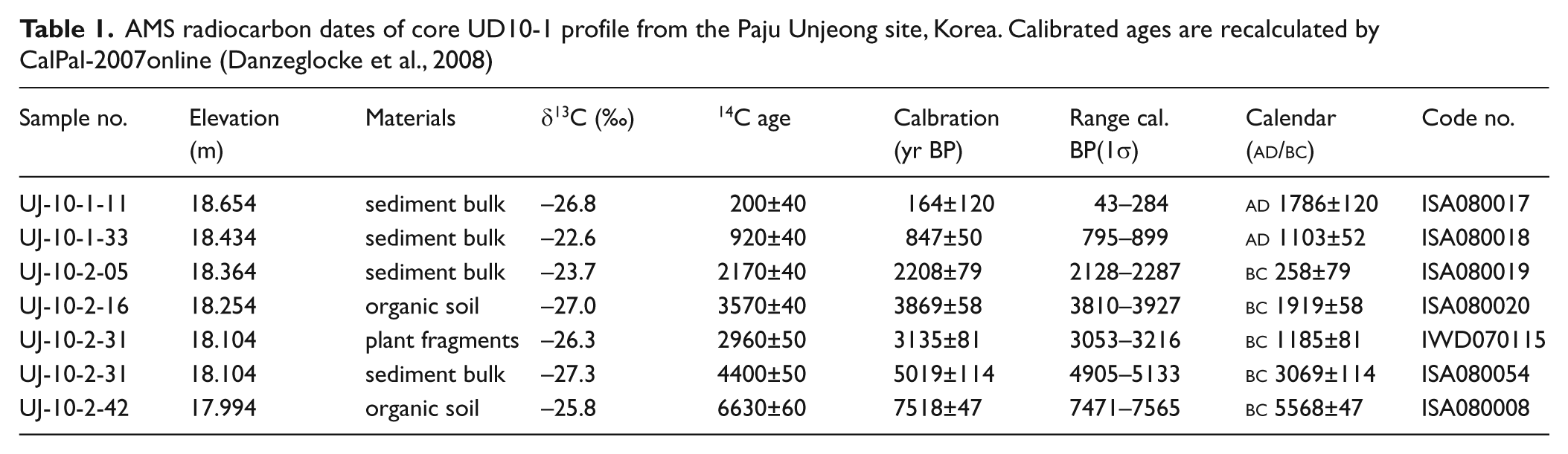
Six samples from the core profile were subjected to accelerator mass spectrometry (AMS) radiocarbon dating. The AMS dates of six samples were determined by the AMS Laboratory of the Korea Institute of Geoscience and Mineral Resources (KIGAM), Korea. Two AMS samples taken at the same elevation of 1.104 m yielded two radically different dates, 3135±81 cal. BP (code # IWD070115) and 5019±114 cal. BP (code # ISA080054), respectively (Table 1). However, the dated fragment of sample (# IWD070115) was a piece of plant’s root, which may penetrate down, i.e. below the level of its actual growth. So, we think that the 3135±81 cal. BP age is not the real age of this elevation. In addition, the dates from all the samples, except that one, are getting older with depth in the linear age to depth model, which looks consistent (Figure 2). Therefore the exceptional age date of 3135±81 cal. BP (code # IWD070115) is not used for our interpretation. All dates were calibrated at the 1σ confidence level using the CalPal2007online program by Danzeglocke et al. (2008) with CalPal-2007Hulu calibration data (Weninger and Jöris, 2008). Calibration ages before present (cal. BP) were applied in the present study. I calculated the average for only those age ranges with the highest probabilities. The full details of the six ages in the present study are given in Table 1. The age–depth curve is plotted in Figure 2. The dating shows that the age of the sediment samples from the Paju Unjeong site ranged from c. 7518 to c. 164 cal. BP. The base age of the profile for the pollen study was extrapolated to c. 8420 cal. BP on the basis of the overlying horizons of 7518 cal. BP (17.994 m a.s.l.) and 5019 cal. BP (18.104 m a.s.l.).
AMS radiocarbon dates of core UD10-1 profile from the Paju Unjeong site, Korea. Calibrated ages are recalculated by CalPal-2007online (Danzeglocke et al., 2008)
A total of 57 dried sediment samples of 5 g were used for pollen and microcharcoal analyses at an average 2 cm depth interval. Standard pollen preparation techniques (Moore et al., 1991) were used. Three exotic Lycopodium spore tablets were added to each sample before further preparation to estimate the pollen and microcharcoal concentrations (Stockmarr, 1972). HCl (30%) was used to dissolve calcareous minerals, and HF (45%) treatment was used to remove siliceous materials. The organic matter recovered was separated from undigested mineral detritus using ZnCl2 (2.0 g/cm3), and acetolysis was used to remove cellulose and humic debris. The residues were strew-mounted on glass slides using glycerin jelly. Pollen grains were counted (up to 300 grains per slide) with an optical microscope, mostly at 400× magnification, except when difficulty in identification required a higher magnification of 1000×.
Pollen identification was aided by the use of published works with illustrations (Chang, 1986; Chang and Rim, 1979). Pollen grains were mostly assigned to the lowest taxonomical level, usually genus and family. Gramineae pollen grains were classified into two categories based on diameters of <35 µm and ≥35 µm, but the division is not discussed in detail because this threshold-size method is not an entirely precise determination (Kim, 1994; Maloney, 1990; Nakamura, 1974; Tweddle et al., 2005). Microcharcoal was identified in classes of 25–50 µm, 100–150 µm, and 150–200 µm. Only charcoals larger than 50 µm in length were plotted on the pollen diagram, as most of the smaller particles could be derived from bigger charcoal fragments (Shu et al., 2010). Pollen diagrams were constructed using TILIA and TGView software (Grimm, 1991, 1993).
Results
All dates directly related to this study are hereafter referred to in the calibrated form (cal. BP) of the midpoint of the 1σ range. Dates arrived at by interpolation or extrapolation from the relevant age–depth relationship are prefixed with ‘c.’.
Zonation was determined based on levels of human activity and environmental dynamics and subzones were determined in light of fluctuations in critical pollen and microcharcoal to facilitate discussion of vegetation changes and human disturbances. Three zones (UD10-I to UD10-III) from 18.764 to 17.954 m a.s.l. were erected using characteristics of the fluctuations in the critical pollen components and CONISS in TGView software (Grimm, 1987). No pollen grains were recorded in a barren zone between 17.924 and 17.154 m a.s.l . Additionally, pollen recorded between 17.714 and 17.684 m a.s.l. was considered to be contamination from sludge during coring (Figure 3). Pollen characteristics of each zone are explained in ascending order. Ages of local pollen zone boundaries were also established by interpolation using the age–depth curve shown in Figure 2.
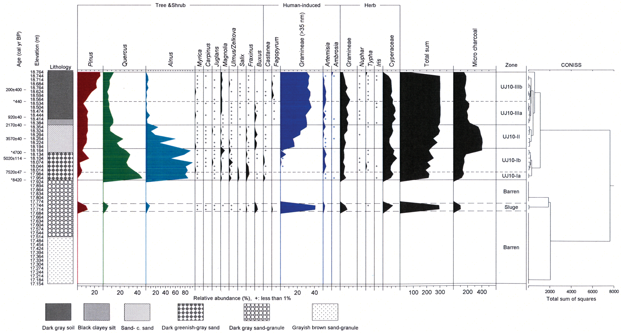
Selected pollen diagram of the UD10-1 core in the Paju Unjeong site. Only major taxa are shown. Calibrated radiocarbon dates are shown on the left of the diagram. The dendrogram on the right was generated by constrained cluster analysis with CONISS. Asterisks indicate age determinations of pollen zone boundaries as calculated by interpolation or extrapolation using the in age–depth curve in Figure 2
Zone UJ10-I (elevation 17.954–18.164 m a.s.l., c. 8425–4700 cal. BP)
This zone was quantitatively dominated by Quercus and Alnus together with a few broadleaved deciduous trees of Fraxinus, Ulmus/Zelkova, Magnolia, and Castanea, and the conifer Pinus. The dominant herbs were members of Cyperaceae, with common Gramineae (<35 µm) and Artemisia. In addition, accessory trees and shrubs and herbaceous taxa were present throughout this zone.
Subzone UJ10-Ia (elevation 17.954–17.984 m a.s.l., c. 8425–7520 cal. BP) was characterized by the predominance of hardwood trees of Quercus and Alnus and herbs of Cyperaceae. The common pollen grains were trees of Fraxinus, Ulmus/Zelkova, Magnolia, Salix, and Castanea, and herbs of Gramineae (<35 µm) and Ambrosia.
Subzone UJ10-Ib (elevation 17.984–18.164 m a.s.l., c. 7520–4700 cal. BP) was dominated by Quercus, Alnus, and Cyperaceae, which gradually declined, in combination with common Pinus, Magnolia, Ulmus/Zelkova, Gramineae (<35 µm), and Artemisia. The occurrence of Pinus somewhat increased upward within this subzone. Other accessory taxa occurred sporadically.
Zone UJ10-II (elevation 18.164 –18.354 m a.s.l., c. 4700–2170 cal. BP)
This zone was characterized by the dominance of Pinus, Quercus, Gramineae (≥35 µm), Gramineae (<35 µm), and Cyperaceae. Common elements included hardwood trees of Magnolia and Buxus and herbs of Artemisia associated with a few Myrica, Carpinus, Juglans, Ulmus/Zelkova, Fraxinus, Castanea, and Ambrosia. This zone was defined by a distinct decrease in Quercus and Alnus deciduous broadleaved trees and an apparent increase in Pinus conifers and Gramineae (≥35 µm) and Gramineae (<35 µm) herbs toward the top of the zone. Tilia was noted to preside only within this zone.
Zone UJ10-III (elevation 18.354 –18.764 m a.s.l., c. 2170 cal. BP–Modern)
This zone was conspicuously marked by the growing dominance of Pinus, Gramineae (≥35 µm), Gramineae (<35 µm), and Cyperaceae, replacing Quercus and Alnus, which decreased dramatically. Common taxa were the pollen grains derived from Magnolia and Artemisia, together with a few Ulmus/Zelkova, Myrica, Carpinus, Juglans, Salix, Fraxinus, and Castanea. Pollen grains of Fagopyrum and Ericaceae appeared only within this zone. The boundary of the subzone was designated by a sudden increase in Pinus, Fagopyrum, and Artemisia, and the first appearance of Ericaceae.
Subzone UJ10-IIIa (elevation 18.354 –18.534 m a.s.l., 2170–c. 440 cal. BP) featured the predominance of herbs, Gramineae (≥35 µm), and Cyperaceae associated with common Pinus, Quercus, and Gramineae (<35 µm). Quercus pollen gradually decreased, whereas Pinus, Gramineae (≥35 µm), and Artemisia pollen grains gradually increased toward the top boundary. Moreover, the pollen grains of Quercus and Alnus obviously decreased, whereas Gramineae (≥35 µm) and Gramineae (<35 µm) conspicuously increased compared with frequencies in the preceding zone.
Subzone UJ10-IIIb (elevation 18.534–18.764 m a.s.l., c. 440 cal. BP–Modern) was characterized by Pinus and Gramineae (≥35 µm), which were the prominent contributors and occurred in very abundant amounts. This zone was marked by an obvious increase in Pinus and an apparent decrease in Gramineae (<35 µm), Cyperaceae, and Artemisia. Quercus and Gramineae (≥35 µm) were continuously present.
Discussion
Age-controlled pollen and microcharcoal stratigraphy revealed the response of vegetation dynamics to climate changes and human disturbances during the time of deposition covering approximately the past 8420 years in the Paju Unjeong area, located in the central western region of the Korean Peninsula. The sedimentary succession of vegetation fluctuation and human impact, together with previous archaeological studies, is discussed in terms of the natural vegetation stage and human-induced vegetation stage and is summarized in Figure 4.
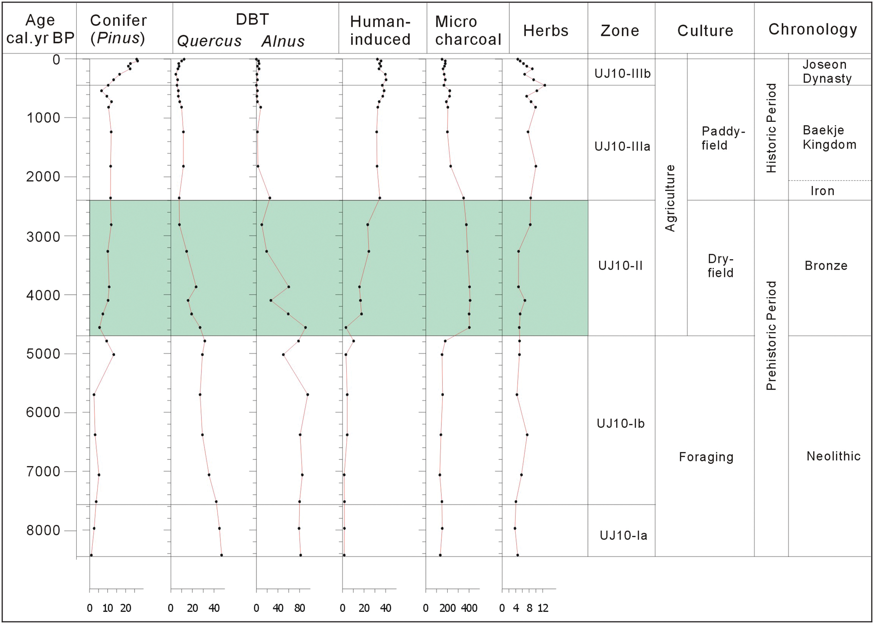
Comprehensive schematic diagram showing the relationship between vegetation and human impact during the last approximately 8420 years. Shaded area, strong woodland destruction. DBT, deciduous broadleaved trees; Qu, Quercus; Al, Alnus. Anthropogenic taxa include Castanea, Artemisia, Ambrosia, and Gramineae (≥35 µm)
Natural vegetation stage (c. 8420–4700 cal. BP): Early Neolithic
This stage is represented by zone UJ10-I, in which the vegetation community consists of deciduous broadleaved trees, indicating dense woodlands during the mid-Holocene period, closely comparable with the hypsithermal period in adjacent areas (Jang et al., 2006; Jun et al., 2010; Park and Yi, 2008; Yi et al., 2008a, b; Yoon, 1997).
The postglacial climate amelioration toward warming and strengthening of summer monsoons enhanced the flourishing of various hardwood trees during the early to mid Holocene in Korea (Chung et al., 2010; Jang et al., 2006; Jun et al., 2010). Forests became dense, especially on well-drained hills to uplands, as reflected by abundant levels of oak (Quercus) and moderate magnolia (Magnolia), elm (Ulmus), zelkova (Zelkova), and ash (Fraxinus), combined with hardwood trees of chestnut (Castanea), myrtle (Myrica), wild walnut (Juglans), and carpinus (Carpinus). In addition, riparian, alder (Alnus), and willow (Salix) inhabited the riverside (Figure 3).
Furthermore, favorable environmental conditions contributed to the occupation by early-Neolithic foraging people of the Paju Unjeong area, where early humans preferred to collect the fruits of wild plants such as the abundant acorns. During this stage, oak was the major wood manipulated by humans in the local area; humans may have maintained it for its acorns, an important food resource. This maintenance may have constituted the main effect of early Neolithic foraging cultures on woodlands.
The fluctuation in vegetation during this stage was primarily driven by climate changes rather than by human impact. The decline in deciduous broadleaved forests is clearly marked in the subzone UJ10-Ib, where oak (Quercus) and alder (Alnus) gradually decrease and are replaced by pine (Pinus) and wild grasses of Gramineae (<35 µm) and mugwort (Artemisia), indicating a relatively cool and dry climate.
Land-use vegetation stage (c. 4700 cal. BP–Modern): Late Neolithic to Modern
This stage corresponds to the zone UJ10-II to UJ10-III, represented by dramatic fluctuations in critical components of the pollen profile. Overall, this stage is characterized by a marked shift in vegetation from forests to Gramineae-dominated open landscape (Figure 3). The indications of climate change are overshadowed by those of intense human impact.
Dry-field farming preceded paddy-field production in the Korean Peninsula and continued to be important long after paddy-field systems developed (Crawford and Lee, 2003). According to the results of archaeological and archaeobotanical studies (Ahn, 1997; Crawford and Lee, 2003), the Neolithic foraging people’s culture changed to settlements on lowland or hills and a farming culture, which developed agricultural cultivation methods such as dry-field or paddy-field farming in Korea. Since that time, human disturbance in woodlands has increased. Hereafter, I will discuss the division of dry-field and paddy-field cultivation stages based on pollen data with the aid of the results of the previous archaeological studies.
Dry-field cultivation stage (c. 4700–2000 cal. BP): Late Neolithic to Bronze Age
The pollen profile of zone UJ10-II shows that oak (Quercus) and alder (Alnus) trees clearly decrease and constantly decline upward; in contrast, pine (Pinus) trees distinctly become more abundant compared with the preceding stage, encompassing zone UJ10-I. Inhabitants may have used fires as a main means to open lowland vegetation for occupation, wood reclamation, and artifact making. This assumption is supported by the increasing abundance of microcharcoal in zone UJ10-II and the gradual and consistent reduction in oak. Moreover, anthropogenic Gramineae (≥ 35µm) occur and show a subsequent dramatic percentage growth. In addition, this stage is characterized by abundant microscopic charcoal.
On the other hand, Zong et al. (2007) and Innes et al. (2009) mentioned the retreat of the alder (Alnus) community because of human clearance by fire. The main targeted hardwood trees for human management were diverse woods including oak (Quercus), alder (Alder), wild walnut (Juglans), magnolia (Magnolia), and myrtle (Myrica). The reduced level of microcharcoal in the upper part of the zone may be assumed to have been caused by the shortage of available woods because of the nearly complete removal of forests or by a possible shift in strategies for managing the landscape.
Agricultural activities conducted at or near coasts and riversides during the early Neolithic period spread widely inland for the management of farmland and shelters by deforestation and reclamation during the late Neolithic (Lee, 2000; Shin, 2000). Moreover, because of the low level of land productivity, it may be assumed that the Neolithic people cut down large amounts of adjacent woodlands for the purpose of wide dry-field cultivation. The Neolithic agricultural people used farming tools and logging instruments for forest exploitation in the Korean Peninsula from the early Neolithic period (Ahn, 1997; Cho, 2004; Crawford and Lee, 2003). After 4000 cal. BP, the ancient people developed a practice of reclaiming dry-field areas by burning woodland; furthermore, they strategically developed an agricultural method of leaving land fallow to secure new field areas. Therefore, this kind of new agricultural technology and methods for woodlands increased forest destruction.
Rice-paddy cultivation in Korea began at the commencement of the Bronze Age (3000–2300 cal. BP), which extended from the first step of the Bronze Age to the early Iron Age (2300–2000 cal. BP) (Cho, 2004). Bronze Age people further developed techniques for reclaiming rice paddy fields and established irrigation systems and various customs associated with rice paddy cultivation.
The interpretation that these people engaged in multipurpose felling is supported by unearthed Neolithic artifacts, such as a home hatchet, a wheel blade of axe, a saw-toothed blade of an axe, and a large logging axe (Ahn, 1997; Lee, 2000; Shin, 2000).
Paddy-field cultivation stage (c. 2000 cal. BP–Modern): Iron Age to Modern
The pollen profile of zone UJ10-III is characterized by abundant Gramineae (≥ 35µm) and pine (Pinus), which apparently decrease in subzone UJ10-IIIa and increase again toward subzone UJ10-IIIb. However, oak (Quercus) occurs constantly throughout, and alder (Alnus) appears in low levels, as compared with those of the preceding stage encompassing zone UJ10-II.
Human activity increased extensively from the beginning of subzone UJ10-IIIa, when the previous human-induced forest was drastically transformed into Gramineae (≥35 µm) vegetation. The strong human disturbance is well represented by the dominance of Gramineae (≥35 µm) and Pinus, the great retreat of Quercus, and the first occurrence of buckwheat (Fagopyrum) in low levels. During this stage, the local area became an extensive open landscape on which humans mainly utilized constant fires to manage woodlands at limited levels to establish more open habitat. This strategy was presumably successful to meet the needs of a possible population increase, rice food production, and settlement expansion, and thus prompted the prosperity of the Baekje Culture, which is one of the Three Kingdoms in Korean chronology.
In subzone UJ10-IIIb (c. 440 cal. BP), pine (Pinus) drastically increases, although oak (Quercus) and Gramineae (≥35 µm) consistently occur. Pine trees may have been strategically planted as secondary forestation because this tree was used as an essential timber to build houses during the Joseon Dynasty (seventeenth century). This interpretation is supported by Korean history documentation (Annals of the Joseon Dynasty), which explained that the central government encouraged pine afforestation.
From compiled pollen data and artifacts, it appears that Iron Age peoples created diverse agricultural instruments, resulting in enhanced cultivation and deforestation of natural forests, as indicated by artifacts such as wood-processing axes, medium and large wood-logging axes, and big steel axes, which were discovered across the Korean Peninsula (Ahn, 2010). They managed reclamation of woodlands and farming fields by fire and by wood cutting. In the beginning of this historical era, the Baekje people (c.
Conclusion
Age-controlled pollen and microcharcoal records in the 160 cm long core covering the Holocene of the UJ-10 core obtained from the Paju Unjeong site located in the central western Korean Peninsula reflect the response of vegetation dynamics to climate changes and human activity. Pollen profiles clearly illustrate a differentiation between the natural vegetation stage and the land-use vegetation (human-affected) stage. The land-use vegetation stage can be further divided into the dry-field cultivation stage and the paddy-field cultivation stage. The natural vegetation stage (zone UJ10–I, c. 8420–4700 cal. BP, early Neolithic) indicates that the dense woodlands, consisting of various deciduous broadleaved trees on well-drained hills to uplands, were caused by postglacial climate amelioration and strengthening of summer monsoons during the mid-Holocene period. The fluctuations in the vegetation were primarily driven by climate changes rather than by human impact. In addition, early Neolithic foraging eoples occupied the forests and collected the fruits of wild plants, such as acorns. The land-use vegetation stage (zone UJ10–II and III, c. 4700 cal. BP, late Neolithic to Modern) reflects the forest transition; and finally, the Gramineae-dominated open landscape replaced the former dense woodlands. During the dry-field cultivation stage (zone UJ10-II, c. 4700–c. 2000 cal. BP, late Neolithic to Bronze Age), dramatic changes in oak, alder, and grass (Gramineae), together with abundant microcharcoal, indicate that inhabitants may have used fires as a main means to open lowland vegetation for occupation, wood reclamation, and artifact making. During the paddy-field cultivation stage (zone UJ10-III, c. 2000 cal. BP, Iron Age to Modern), the pollen profile, represented by abundant grass (Gramineae) and fluctuating pine, may imply that the inhabitants’ activities became intense. The local area became an extensive open landscape on which humans utilized constant fires to manage woodlands at limited levels for more open habitat during the time of zone UJ10-IIIa, comparable with the Baekje Culture (c.
Footnotes
Acknowledgements
Two anonymous reviewers are sincerely thanked for their constructive comments.
This research (GP2009-005) was supported by the Basic Research Project of the KIGAM, funded by the Ministry of Knowledge Economy of Korea.