



Abstract
Dendroglaciological investigations near Mt. Waddington in the central British Columbia Coast Mountains provide an enhanced perspective of Holocene glacial activity. Field investigations at Confederation, Franklin, and Jambeau glaciers led to the discovery of subfossil wood mats encased in glacial deposits and glacially sheared stumps buried beneath till. Radiocarbon-dated wood collected from valley-bottom and lateral moraine sites at Confederation Glacier suggest that an early-Holocene advance occurred at c. 5665 cal. yr BP, followed by succeeding intervals of glacier expansion at c. 3700 and 3500 cal. yr BP. At Jambeau Glacier detrital wood mats buried close to the contemporary lateral moraine crests document glacier expansion at c. 3000 cal. yr BP. Detrital subfossil wood buried in lateral moraines at the confluence of Confederation and Franklin glaciers records distinct episodes of ‘Little Ice Age’ glacier expansion as early as c. 1212 cal. yr
Introduction
Many glaciers in the British Columbia (BC) Coast Mountains reached their maximum Holocene extent during the ‘Little Ice Age’ (LIA) (Menounos et al., 2009). Following the LIA, glaciers in the region experienced substantial volumetric losses (Schiefer et al., 2007; VanLooy and Forster, 2008) and are now surrounded by bare till-mantled forefields and recent glaciofluvial deposits (Allen and Smith, 2007; Koehler and Smith, 2011). These features often overlie older glacial deposits, hampering efforts to reconstruct records of pre-LIA glacier activity (Koch et al., 2007a; Reyes et al., 2006).
The temporal and spatial resolution of our understanding of Holocene glacial history in the Coast Mountains has grown substantially over the past decade (Menounos et al., 2009). Field studies throughout the region have led to the discovery of recently exposed remains of glacially killed trees and detrital wood deposits (Allen and Smith, 2007; Jackson et al., 2008; Koch et al., 2009; Koehler and Smith, 2011; Osborn et al., 2007); findings that provide evidence of repeated intervals of ice front advance and retreat over the past 10,000 years (Menounos et al., 2009).
Despite pioneering observations by Munday (1931) and reconnaissance surveys by Ryder and Thomson (1986), limited attention has been directed to dendroglaciological investigations in the vicinity of Mt. Waddington in the central Coast Mountains. This remote, high-relief landscape contains some of the highest peaks in BC and is distinguished by enhanced precipitation regimes that create a distinct and little-studied glaciological setting. The area is characterized by large valley glaciers (Clarke and Holdsworth, 2002) that began receding from their LIA terminus positions early in the 20th century (Munday, 1931). Many glaciers are now surrounded by extensive unvegetated forefields (Larocque and Smith, 2003) and large lateral moraines containing wood mats related to distinct Holocene advances (Menounos et al., 2008; Ryder and Thomson, 1986).
Reconnaissance investigations were undertaken at three glaciers in the Mt. Waddington area to discern the local synchronicity of Holocene glacial activity. In 2008, surveys were completed west of Mt. Waddington near the confluence of Confederation and Franklin glaciers. In 2009, surveys were undertaken south of Mt. Waddington at Jambeau Glacier. This paper presents our dendroglaciological findings and refines the chronology of mid- to late-Holocene glacier activity in the study area.
Research background
The extent and volume of Coast Mountain glaciers has fluctuated in concert with climate shifts over the Holocene epoch (Mayewski et al., 2004). There is limited evidence for an early-Holocene advance c. 8000 cal. yr BP (Menounos et al., 2004), after which glaciers receded and downwasted before the initiation of mid-Holocene advances at c. 6400 to 5800 cal. yr BP (Ryder and Thomson, 1986). Following this interval of glacier expansion, advances in c. 4200 cal. yr BP (Menounos et al., 2008) and c. 3500 cal. yr BP resulted in some glaciers, such as Tiedemann Glacier in the Mt. Waddington area (Fulton, 1971; Ryder and Thomson, 1986), achieving their maximum Holocene extent.
Following these mid-Holocene advances, many Coast Mountain glaciers retreated and downwasted before readvancing in the late Holocene at c. 3000 cal. yr BP (Allen and Smith, 2007; Jackson et al., 2008) and 2300 cal. yr BP (Koehler and Smith, 2011). By c. 1800 cal. yr BP, glaciers throughout the region were expanding into living forests again before retreating sometime after 1500 cal. yr BP (Reyes et al., 2006).
Glaciers in the Coast Mountains were readvancing by 1000 cal. yr BP in response to LIA climatic cooling (Allen and Smith, 2007). While distinct LIA advances are recognized from c. 1100–1200, 1600–1700 and 1850–1900 cal. yr
Study area
Mt. Waddington (4019 m a.s.l.) is the principal summit of the heavily glaciated Waddington Range (Figure 1). The regional climate is strongly influenced by weather systems originating in the Pacific Ocean, with annual air temperatures averaging 1.1°C and annual precipitation totals exceeding 1700 mm/yr (Wang et al., 2005).

Map of the Mt. Waddington area, highlighting localities mentioned in the text and glacial extent in 2001 (basemap: Landsat 7 orthoimage 2001).
Field investigations were completed at Confederation, Franklin, and Jambeau glaciers (Figure 1). The confluence of Confederation and Franklin glaciers is located 17 km west of the summit of Mt. Waddington and 18 km from the head of Knight Inlet (Figure 1). Both glaciers descend to terminus positions well below the local treeline.
Confederation Glacier flows southwest down bedrock-confined Confederation Valley (unofficial name) below Mts Myrtle and Bezel (2700 m a.s.l.). At its maximum Holocene extent, Confederation Glacier filled the 8 km long valley and was confluent with Franklin Glacier. A photograph from the late 1920s shows the surface of Confederation Glacier positioned within 50 m of the lateral moraine crest at 1255 m a.s.l. (Figure 2a).
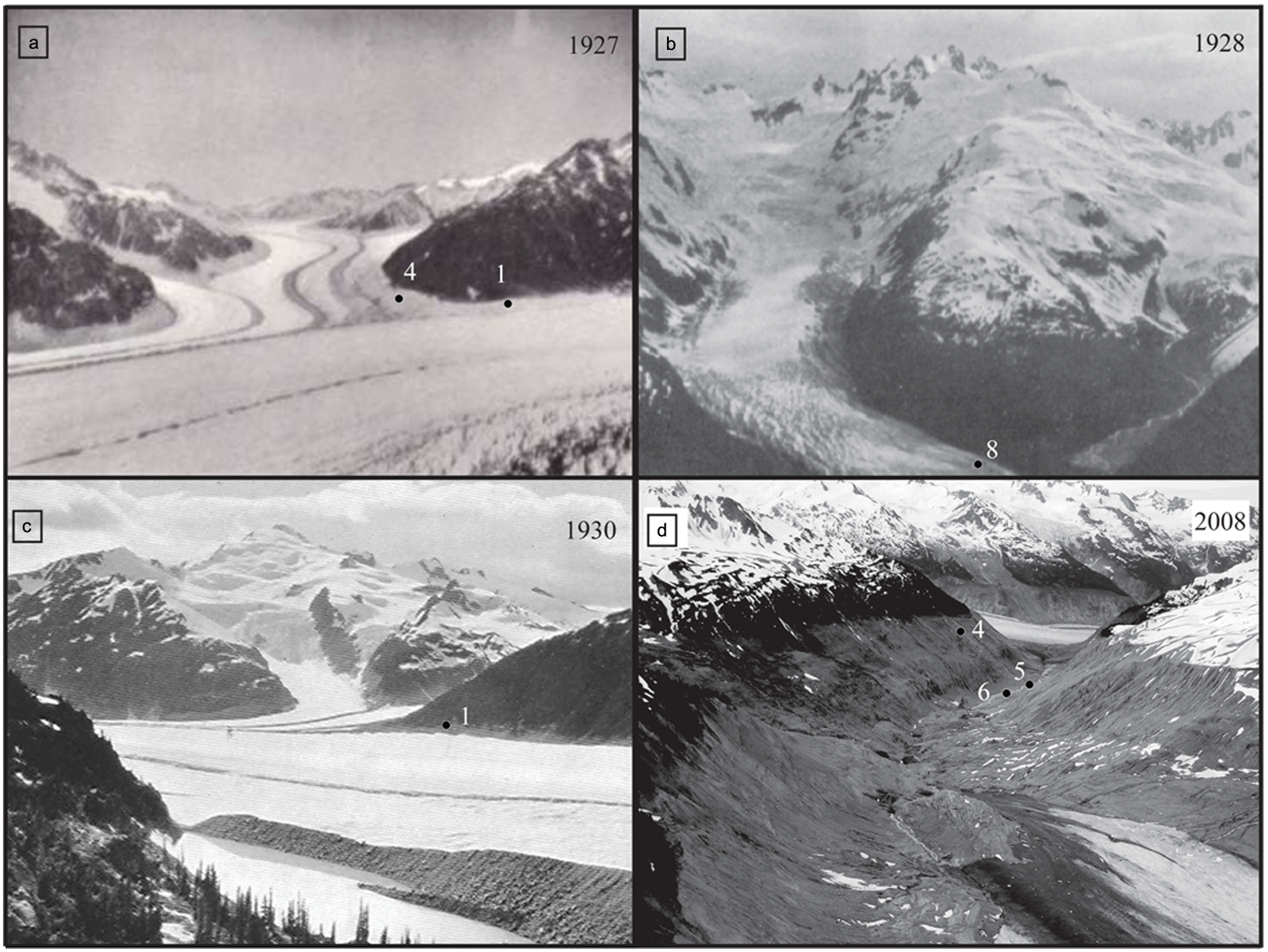
Historical photographs from the Mt. Waddington area. (a) Confederation Glacier in Confederation Valley (background) and confluent Franklin Glacier (foreground) with study sites 1 and 4 shown (Munday, 1926–1927:14); (b) Jambeau Glacier (left) and Avalanche Glacier/Scar Creek (right) with the location of site 8 shown (Munday, 1934–1935: 65); (c) Confluence of Franklin (foreground) and Confederation glaciers with tributary Splendor Glacier in the background. Location of site 1 shown (Munday, 1930: 87); and, (d) Confederation Valley depicting the Confederation Glacier snout (foreground) and Franklin Glacier (background). Photograph taken during the 2008 field season.
Franklin Glacier is a 12 km long trunk valley glacier flowing southwest from Mt. Waddington (Figure 1). A photograph from 1927 shows Franklin Glacier close to its LIA limit, with a sizeable medial moraine extending downvalley from the Confederation and Franklin glacier confluence (Figure 2a and c). Franklin Glacier has retreated and downwasted appreciably in recent decades. VanLooy and Forster (2008) report that the glacier terminus retreated upvalley 4.1 km (average 56 m/yr) from 1926 to 1999. This period of retreat was interrupted by minor stillstands and short-lived frontal advances (Munday, 1930).
Jambeau Glacier is located 15 km south of Mt. Waddington in the Whitemantle Range (Figure 1). The glacier historically flowed northeast to emerge from a tributary valley and blockade Scar Creek valley. Over the last 80 years the glacier snout has receded almost 1 km from where it was first photographed in the 1920s (Figure 2b).
Research methods
Field investigations focused on the collection of subfossil wood samples buried by advancing or thickening glaciers. The kill dates of trees overwhelmed, reworked, and preserved within moraine or forefield sediments represent minimum dates for individual glacial events, while the locations and kill dates of tree remains found in growth position demarcate the location of contemporaneous ice margins (Smith and Lewis, 2007).
Standard dendroglaciological research methods rely on living tree ring-width chronologies to situate floating (undated) subfossil tree-ring series in time (Luckman, 1998). Where subfossil wood exceeds the age of the available living tree ring-width chronologies, 14C dating of perimeter wood is used to date floating chronologies (Wood and Smith, 2004). Floating chronologies can be temporally extended by integrating older or younger tree-ring data from the remains of opportunistically collected detrital subfossil wood (Koehler and Smith, 2011).
Subfossil samples were collected by removing cross-sections from the trunks of detrital wood remains with a chainsaw and wrapping them in duct tape. Two core samples were collected from living trees with 5.2 mm increment borers to allow for correction of concentric growth variations (Fritts, 1976). The cores were stored in plastic straws and transported to the University of Victoria Tree-Ring Laboratory for analysis where they were dried and glued to slotted mounting boards. The subfossil samples were glued where necessary to preserve their structural integrity. Both sample sets were polished with progressively finer sandpaper to either a 600- or 1200-grit finish to enhance the annual ring boundaries. The width of each ring was measured to 0.001 mm and captured by J2X software (v3.2.1, 1994) using a Velmex measuring stage system and a Wild M3B stereomicroscope equipped with a Sony 3CCD video camera.
Ring-width series were internally crossdated before being compiled to produce site- and/or species-specific master chronologies (Fritts, 1976). Visual crossdates (list method) were verified using the program COFECHA 3.0 (Grissino-Mayer, 2001; Holmes, 1983). Series correlations (r) were calculated by COFECHA and are significant at the 99% confidence level. An attempt was made to establish the absolute age of each floating chronology by crossdating to local and regional living ring-width chronologies (Allen and Smith, 2007; Hart et al., 2010; Jackson et al., 2008; Koehler and Smith, 2011; Larocque and Smith, 2005; Parish and Antos, 2006; Smith and Laroque, 1998).
Where crossdating failed, the outer rings from selected samples contributing to the floating chronologies were radiocarbon-dated by Beta Analytic Inc. Radiocarbon dates were used to assign relative calendar ages to the floating chronologies (Program CALIB 6.0; Stuiver et al., 2005) using the IntCal09 radiocarbon curve of Reimer et al. (2009). Calendar ages were ascribed using a cubic spline fit (Talma and Vogel, 1993) and the median value of the dominant peak is reported (Telford et al., 2004). Multimodal distributions within the probability density functions of the dominant 2 sigma ranges are reported, where present. Dates are presented in calendar years BP (cal. yr BP), with the exception of LIA dates which are reported as calibrated years
Summary of radiocarbon ages related to Holocene glacier activity in the Mt. Waddington area.
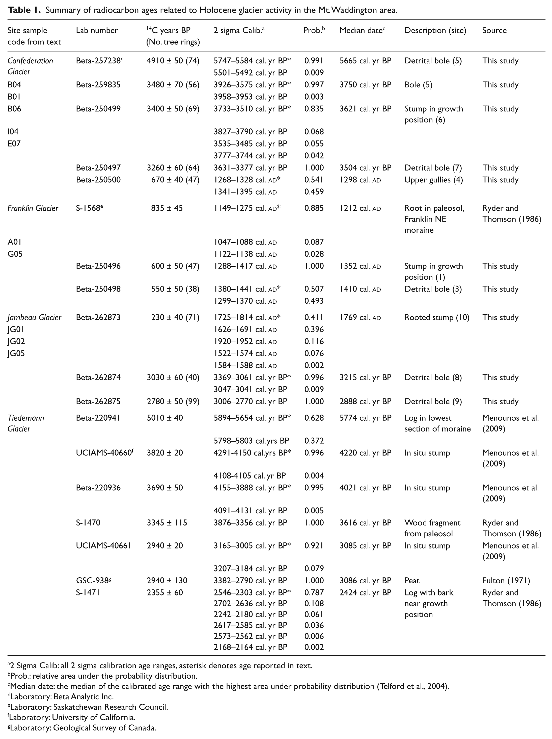
2 Sigma Calib: all 2 sigma calibration age ranges, asterisk denotes age reported in text.
Prob.: relative area under the probability distribution.
Median date: the median of the calibrated age range with the highest area under probability distribution (Telford et al., 2004).
Laboratory: Beta Analytic Inc.
Laboratory: Saskatchewan Research Council.
Laboratory: University of California.
Laboratory: Geological Survey of Canada.
Preliminary species identification of all subfossil wood samples was completed using a 40× microscope and a standard reference key (Hoadley, 1990). Representative samples were subsequently examined in detail to confirm the identification using a Motic BA310 microscope. Radial, tangential, and transverse thin sections (20–30 μm), cut from the samples with a sliding microtome, were washed in an ethanol bath and mounted on glass slides. The sample species were then identified with reference to anatomical keys (Friedman, 1978; Panshin and Zeeuw, 1980).
Observations
Confederation Glacier
In 2008, Confederation Glacier extended downvalley approximately 6.5 km to a terminus position at 1400 m a.s.l., close to the point of confluence with tributary Splendor Glacier valley (Figures 1, 2c). Ice retreat has exposed a 4 km long till-mantled expanse of forefield and steep-sided valley slopes (Figure 2d). In the lower valley an area of stagnating ice extends from the perimeter of Franklin Glacier into Confederation Valley. Immediately upstream of the ice is a 200 m long terraced unit of sorted sand that exceeds 6 m in depth and contains the remains of numerous subfossil boles.
The 200 m high lateral moraines flanking the valley are heavily eroded, exposing underlying bedrock units along much of the mid-valley margin (Figure 2d). The lateral moraine crests consist of a series of bare to partially vegetated nested moraines, previously attributed to distinct intervals of LIA glacier expansion (Ryder and Thomson, 1986). Explorations on the slope above the LIA moraines led to the discovery of a forested lateral moraine associated with an undated episode of Holocene glacier expansion. Exposed within the proximal face of the lateral moraines are till units separated at intervals by mats of detrital wood. Many of the steep gullies eroded into the moraine contain detrital wood fragments, as do the surfaces of the underlying postglacial talus slopes.
The surrounding montane forests are dominated by mountain hemlock (Tsuga mertensiana) and subalpine fir (Abies lasiocarpa) trees. Undisturbed valley bottom forests west of Mt. Waddington are composed primarily of western red cedar (Thuja plicata) and western hemlock (Tsuga heterophylla) trees, whereas valley bottoms east of the Waddington Range are dominated by Douglas-fir (Pseudotsuga menziesii) and Engelmann spruce (Picea engelmanni) trees (Meidinger and Pojar, 1991).
Franklin Glacier
In 2008, the terminus of Franklin Glacier was located approximately 4 km downvalley from its point of confluence with Confederation Valley at 610 m a.s.l. (Figure 1). Lateral moraine crests flanking Franklin Glacier stand 175 m above the ice surface. As noted by Munday (1930), the moraines are composite landforms reflecting several intervals of expansion and downwasting (Figure 2c). A prominent proximal exposure in the Franklin Glacier lateral moraine, close to the Confederation valley confluence, contains two horizontal till units separated by detrital boles with visible tree roots. A buried tree root found in growth position at this contact was interpreted by Ryder and Thomson (1986) to indicate that Franklin Glacier was expanding vertically and advancing downvalley at 835±45 14C yr BP (S-1568, Table 1).
Jambeau Glacier
Jambeau Glacier extends 6 km down a tributary valley to Scar Creek (Figure 1). In 2009, the snout of the glacier was located at 1080 m a.s.l., upstream of a recently deglaciated valley floor characterized by bare bedrock and glaciofluvial deposits.
Jambeau Glacier constructed large lateral moraines where it intersected Scar Creek valley. Reaching heights of 150 m to a crest at 1085 m a.s.l., the northwest lateral moraine dams meltwater released by Avalanche Glacier in the Scar Creek headwaters (Figure 2c). The proximal face of the moraine contains a laterally continuous mat of detrital boles and stumps 10 m below the crest. The southeast lateral moraine emerges from Jambeau Glacier valley, continuing down Scar Creek valley to an LIA terminus position at 820 m a.s.l. Exposures within the vertical moraine face, close to where it joins the trunk valley, reveal a laterally continuous mat of woody detritus overlying a weakly expressed buried soil horizon.
Results
Living tree ring-width samples were collected in a mature mountain hemlock and subalpine fir forest located above the ice limit near the confluence of Confederation and Franklin glaciers (Figure 1). Thirty-one cores from 16 trees were included in the living mountain hemlock chronology constructed for this study (Site A, Table 2). The chronology spans 409 years (
Tree-ring chronology statistics.

Calculated using the computer program COFECHA; 50 year segment lengths with a 25 year overlap.
Mean sensitivity: referring to the presence of annual variability in the tree-ring width series, which indicates that a tree is ‘sensitive’ to variations in climate (Fritts, 1976). Measured from 0.650 (very sensitive) to 0.150 (very complacent).
Autocorrelation coefficient: a measure of the correlation between the ring width in year n and the width in year n−1. Measured from 0 (no autocorrelation) to around −0.009 (high negative autocorrelation) and around 0.900 (high positive autocorrelation).
Wood samples were collected from sheared stumps found in growth position and from detrital boles entombed in glacial deposits. Detrital wood was also collected on valley floors and from talus deposits below eroding and collapsing moraine faces.
Study sites
Mountain hemlock boles with mean diameters exceeding 1 m protrude laterally from an organic layer positioned between massive till units and exposed by erosion of the Franklin lateral moraine at site 1 (Figure 1). Located 10 m below the crest, the site is likely that examined by Ryder and Thomson (1986). While the vertical moraine face rendered most boles inaccessible in 2008, a proximal side gully provided access to a bole spilled into an erosional channel and a rooted stump in growth position (A01 and A04, Table 1; Figure 3a). Tree rings from the two samples cross-date (r=0.610) to produce a 193 yr floating mountain hemlock chronology (F1, Table 2). Perimeter rings from the stump date to 600±50 14C yr BP (A01, Table 1), with the dominant 2 sigma calibrated age range spanning 1288–1417 cal. yr
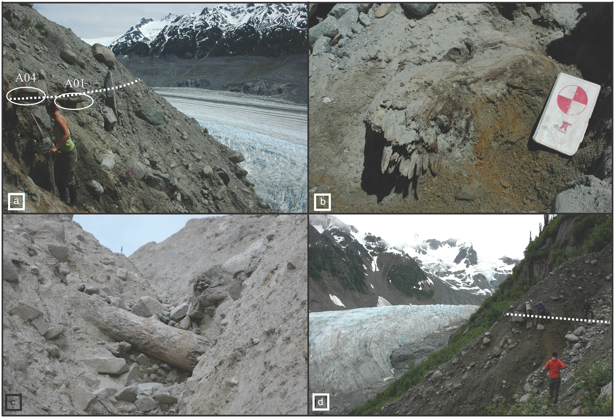
Dendroglaciological sample sites in the Mt. Waddington area: (a) site 1 in an upper gully of the north Franklin Glacier lateral moraine; location of samples A01, A04 and wood horizon pictured with Franklin Glacier below; (b) site 5 in Confederation Valley showing location of sample B01 and paleosol; (c) sample I04 protruding across a gully in the east Confederation Glacier lateral moraine at site 7; and, (d) wood mat in Jambeau west lateral moraine at site 8 with Jambeau Glacier below.
Site 2 is located 120 m below site 1, where detrital mountain hemlock boles eroded from the overlying lateral moraine spill onto a talus slope at 1080 m a.s.l. (Figure 1). Four boles cross-date (r=0.442) to produce a 401 yr long floating chronology (F2, Table 2). Site 3 is located on talus adjacent to Franklin Glacier below the steep and eroding lateral moraine (Figure 1). Woody detritus at the site originates from two horizontal wood-rich layers exposed at approximately 1180 m a.s.l., about 10 m and 15 m from the moraine crest. Mountain hemlock boles on the talus range in length from 2 to 3 m, and from 0.6 to 1.2 m in diameter. Four samples cross-date (r=0.535) to form a 250 yr long floating chronology (F3, Table 2). The outer rings of G05 date to 550±50 14C yr BP (Table 1) with the dominant 2 sigma calibrated age range spanning 1380–1441 cal. yr
Site 4 is located in Confederation Valley on the upper proximal slopes and gullies of the eastern lateral moraine at 1250 m a.s.l. (Figure 1). Samples were collected from detrital mountain hemlock boles exposed in the gully walls or spilled into the channels. Ten boles cross-date (r=0.518) to form a 313 yr long floating chronology (F4, Table 2). Perimeter wood from E07 collected at the same location and dating to 670±40 14C yr BP did not cross-date to F4 (Table 1).
Site 5 is located 3 km downstream from the 2008 terminal position of Confederation Glacier at 990 m a.s.l. (Figure 1). Several large masticated boles were discovered protruding from an incised stream bank and lying on the adjacent channel floor. A sizeable (5.5 m × 0.9 m) mountain hemlock bole (161 rings; B01, Table 1), projecting from a large blocky till unit overlain by sorted sands, dates to 3480±70 14C yr BP. Perimeter wood from a second mountain hemlock bole (175 rings, 5.46 m × 2 m) found lying in the stream channel dates to 4910±40 14C yr BP (B04, Table 1).
Site 6 is located 100 m upstream from site 5 at 990 m a.s.l. (Figure 1). Exposed within a 4 m section of incised stream bank, and positioned downvalley of a projecting boulder, is a glacially sheared stump (B06, Table 1) rooted in growth position within an orange-coloured sandy paleosol (Figure 3b). Perimeter rings from the stump indicate the tree was killed at c. 3400±50 14C yr BP (Table 1).
Site 7 is located 1.5 km upvalley from the 2008 position of the Confederation Glacier ice front at 1775 m a.s.l. (Figure 1). Numerous pieces of detrital wood were discovered on a talus slope below the west-facing Confederation Glacier lateral moraine. A 90 m traverse up the near-vertical moraine face led to the discovery of a 2.5 m long partially entombed mountain hemlock bole protruding across an incised gully channel (I04, Table 1, Figure 3). Perimeter wood from the bole dates to 3260±60 14C yr BP (Table 1).
At site 8, detrital wood was discovered on talus below the west-facing Jambeau Glacier lateral moraine (Figure 1). A traverse up a broad erosional gully led to the discovery of bole fragments buried along a contact between two till units at 1110 m a.s.l. (Figure 3d). A piece of perimeter wood from JG02 dates to 3030±60 14C yr BP (Table 1).
Site 9 is located across the valley from site 1 on the upper proximal section of the east-facing lateral moraine, 30 m below the crest (Figure 1). Numerous large boles, protruding from an extensive wood mat sandwiched by massive till units, are exposed within gullies at 1107 m a.s.l. (Figure 3c). Perimeter rings from JG05 date to 2780±50 14C yr BP (Table 1).
Site 10 is located on the steep lee slopes of a protruding bedrock band along the west Jambeau Valley floor, approximately 250 m from the 2009 ice front (Figure 1). A small sheared stump was discovered rooted within a paleosol among a rubbly spill of boulders at 1040 m a.s.l. (JG01, Table 1). Perimeter wood from the stump dates to 230±40 14C yr BP (Table 1).
Twenty samples collected from wood remains recovered at sites 1–4 cross-date (r=0.469; Table 2) to form a 465 yr long floating chronology (MC-A; Figure 4). MC-A did not cross-date to the local living tree-ring chronology developed as part of this study, or to any existent regional tree-ring chronologies, confirming that the floating chronology pre-dates c. 1599 cal. yr ad. The radiocarbon ages assigned to perimeter rings from two incorporated samples (A01 and G05) (Table 1) indicate MC-A spans the period from approximately 946 to 1410 cal. yr

Schematic of floating tree-ring width chronologies developed from dendroglaciological samples collected in the Mt. Waddington area. Grey bars represent the temporal extent of individual measured paths. Asterisks identify radiocarbon-dated series. Dashed lines identify major kill events. All samples were microscopically identified as mountain hemlock trees.
Tree-rings from samples recovered at sites 5 (B01) and 6 (B06) (Table 1) cross-date to form a 163 yr long floating chronology MC-B (r=0.448) (Table 2, Figure 4). Radiocarbon ages assigned to perimeter rings indicate these trees died in c. 3685 cal. yr BP (average of individual radiocarbon median ages).
Synthesis
Substantial evidence now exists in the study area for most currently recognized Holocene glacial advances (Menounos et al., 2009). Dendroglaciological evidence suggests that glaciers in the Mt. Waddington area were expanding and advancing down-valley in the mid Holocene. At Tiedemann Glacier, a log found buried in lateral moraine sediments dates to 5774 cal. yr BP (Beta-220941, Table 1) and was interpreted to describe a mid-Holocene advance (Ryder and Thomson, 1986). The age assigned to this advance is similar to that attributed to the detrital bole recovered in Confederation Valley at site 5 (5665 cal. yr BP; B04, Table 1), prompting speculation that Confederation Glacier was advancing into mature standing forests at this time. The timing of this mid-Holocene advance is consistent with regional interpretations of glacial activity (Harvey et al., 2012; Menounos et al., 2009). Reports of a climate transition at c. 5860 cal. yr BP in nearby coastal (Galloway et al., 2010) and interior settings (Gavin et al., 2011) suggest glaciers were expanding in response to wetter and/or cooler conditions (Figure 5c, 2). Support for this interpretation is provided by Hallett et al. (2003) who reported that cool conditions led to substantial decreases in the incidence of forest fires in southern BC at this time (Figure 5c, 3).

Comparison of radiocarbon-dated ages of wood collected for this study to regional paleoclimatic records from 6000 cal. yr BP to present. Shown are: (a) the calibrated ages of dendroglaciological samples collected at Confederation, Franklin, and Jambeau glaciers; (b) the intervals over which glaciers were advancing in the Coast Mountains (black bars: as defined by Menounos et al., 2009) and the c. 3800 cal. yr BP advance at Confederation Glacier (hatched bar); and, (c) paleoenvironmental records from southern British Columbia and northwestern Washington State. (c, 1) Presents a sedimentation record from Alison Sound, BC. Higher density values (a) correspond with generally wetter conditions and higher frequency climate fluctuations, while sudden perturbations in mean grain size (b) correspond with major climate shifts. Black dots represent slump events related to cooler conditions (adapted from Patterson et al., 2007). (c, 2) Presents a regional July temperature anomaly record based on chironomid assemblages (adapted from Gavin et al., 2011). (c, 3) Presents two fire frequency reconstructions based on charcoal preserved in soil and lake sediments in the southern Coast and northern Cascade Mountains (adapted from Hallett et al., 2003).
Following this mid-Holocene advance, glaciers in the Mt. Waddington area appear to have downwasted before expanding at c. 4200 cal. yr BP. Menounos et al. (2008) report that Tiedemann Glacier was advancing downvalley at this time, overwhelming valley-side forests and burying rooted stumps in the lateral moraines (UCIAMS 40660 and Beta-220936, Table 1). While no additional evidence of this advance has been discovered at other locations in the Mt. Waddington area, regional evidence of contemporaneous glacier expansion (Harvey et al., 2011; Menounos et al., 2008) suggests glaciers in the study area were also advancing. Regional paleotemperature records (Figure 5c, 2) and paleoenvironmental evidence from the southern Coast Mountains (Chang et al., 2003; Dallimore et al., 2005) suggest that the ice-building at c. 4200 cal. yr BP occurred in response to climate cooling and/or moister conditions. Sediment cores from nearby Frederick Sound similarly describe wetter conditions from 4540 to 2840 cal. yr BP (Galloway et al., 2010).
The MC-B floating chronology from Confederation Valley provides convincing evidence for a glacial advance at c. 3700 cal. yr BP (Figure 4). The glacially sheared stump recovered at site 6 (B06, Table 1) cross-dates to the large bole (161 rings) exposed by stream incision at site 5 (B01, Table 1). These findings, as well as the presence of a paleosol at site 6, confirm that Confederation Glacier was advancing into mature standing forests at least three centuries after the presumed 4200 cal. yr BP event. Similar-aged advances are reported from sites in the southern Coast Mountains at Manatee Glacier (Koehler and Smith, 2011) and in the northern Coast Mountains at Canoe and Bear River glaciers (Harvey et al., 2012; Jackson et al., 2008). The remains of glacially sheared stumps recovered at Boundary Glacier in the Canadian Rocky Mountains (Gardner and Jones, 1985; Wood and Smith, 2004) suggest that glaciers throughout the southern Canadian Cordillera were advancing. Contemporaneous paleotemperature records indicate that cooling temperatures at this time precipitated positive mass balance conditions (Gavin et al., 2011) (Figure 5c, 2); a finding supported by charcoal records that document the initiation of a coincident interval of decreasing fire frequency (Hallett et al., 2003) (Figure 5c, 3).
After overriding trees at site 6 (B06, Table 1) at c. 3500, Confederation Glacier retreated a minimum of 3 km upvalley from this location before readvancing and burying mature trees (> 64 rings) at site 7 at c. 3500 cal. yr BP (I04, Table 1). Reports of a synchronous advance at Tiedemann Glacier (S-1470, Table 1) suggest that glaciers throughout the region were expanding (Fulton, 1971; Ryder and Thomson, 1986), most likely in response to cooler and/or wetter conditions (Gavin et al., 2011) (Figure 5c, 2).
Glaciers at many Coast Mountain sites were advancing downvalley at c. 3000 cal. yr BP (Allen and Smith, 2007; Jackson et al., 2008; Koehler and Smith, 2011; Osborn et al., 2007; Reyes and Clague, 2004; Ryder and Thomson, 1986). Evidence of glacier expansion at Tiedemann Glacier at c. 3085–3086 cal. yr BP (GSC-938 and UCIAMS-40661, Table 1) is reported by Ryder and Thomson (1986) and Menounos et al. (2009). The detrital boles collected from the lateral moraines of Jambeau Glacier date to c. 3215–2888 cal. yr BP (JG02 and JG05, Table 1) and were presumably also killed during this episode. Glacier expansion in the Mt Waddington area at c. 3000 cal. yr BP is coeval with the Peyto Advance in the Canadian Rocky Mountains (Luckman et al., 1993; Wood and Smith, 2004) and is consistent with regional evidence documenting a transition to cooler climates and the establishment of modern subalpine conditions at this time (Walker and Pellatt, 2003). Sedimentological evidence from various lake and marine sediments collected in nearby Alison Sound also supports terrestrial interpretations of pronounced cooling (Patterson et al., 2007) (Figure 5c, 1, a and b).
Following expansion at c. 3000 cal. yr BP, Tiedemann Glacier downwasted and retreated before a return to cooler temperatures at c. 2500–2300 cal. yr BP (Arsenault et al., 2007) resulted in downvalley expansion. Glaciers were expanding throughout the Coast Mountains at this time (Koehler and Smith, 2011; Menounos et al., 2009), likely in response to the cooler and moister conditions recorded in various lake (Gavin et al., 2011; Hallett et al., 2003) (Figure 5c, 2 and 3) and marine sediments (Patterson et al., 2007) (Figure 5c, 1b).
Dendroglaciological investigations at glaciers elsewhere in the Coast Mountains and Alaska describe a substantial episode of glacier expansion at c. 1600–1300 cal. yr BP (Reyes et al., 2006) in response to an interval of wetter and cooler climates (Gavin et al., 2011; Hallett et al., 2003; Patterson et al., 2007) (Figure 5c, 1, 2, and 3). While there is only limited evidence that of glacier activity in the Mt. Waddington area at this time (Ryder and Thomson, 1986), the recent discovery of buried wood dating to 1500 cal. yr BP within ponded sediments adjacent to lateral moraines at Scimitar Glacier north of the study area, suggests glaciers in the Mt. Waddington area were advancing (Craig and Smith, 2012).
In the Mt. Waddington area, LIA glacier activity is characterized by early- and late-LIA advances (Larocque and Smith, 2003). The earliest record of LIA glacier activity is presented by Ryder and Thomson (1986) who report that Franklin Glacier was expanding and burying living trees at c. 1212 cal. yr
Subfossil wood collected during our lateral moraine surveys at Confederation and Franklin glaciers describe two episodes of glacier expansion. The deaths of seven trees at sites 1, 2 and 4 date to between c. 1320 and 1340 cal. yr
Following early 14th century expansion, the downstream surface of the confluent Confederation and Franklin glaciers either stabilized or lowered marginally before rising again to kill mature (> 150 years in age) ice-marginal trees in c. 1410 cal. yr
After
Conclusion
Dendroglaciological evidence from the Mt. Waddington area provides insight into the mid- to late-Holocene behaviour of glaciers in this remote high mountain landscape. Surveys at Confederation Glacier led to equivocal evidence for an advance at c. 5600 cal. yr BP. Expansion of Tiedemann Glacier at 4200 cal. yr BP, and Confederation Glacier in c. 3700 and 3500 cal. yr BP, indicates that glaciers in the Mt. Waddington area may have fluctuated substantially in size and extent during the mid Holocene. Evidence for late-Holocene glacier expansion is recorded by the burial of mature valley-side forests in c. 3000 cal. yr BP at both Jambeau and Tiedemann glaciers. While there is only limited evidence of glacier expansion at c. 2500–2300 and 1600–1300 cal. yr BP in the Mt. Waddington area, these advances are well-documented at sites in the northern and southern Coast Mountains. Glacier expansion in the early LIA was well underway by the 13th century at Franklin Glacier, with continued expansion evidenced by the burial of trees in c. 1330 and 1410 cal. yr ad. Late-LIA glacier expansion at Jambeau Glacier was underway by c. 1740 cal. yr ad. Our findings at Confederation, Franklin and Jambeau glaciers are consistent with the timing of glacier activity reported elsewhere Mt. Waddington area and serve to corroborate the regional synchronicity of mid- to late-Holocene glacier activity in the British Columbia Coast Mountains.
Footnotes
Acknowledgements
We are grateful to Kirsten Brown, Jill Harvey, Sarah Hart, Kate Johnson, Kyla Patterson, and Kara Pitman for their assistance in the field. We thank Patrick Von Aderkas for the use of his microtome.
Funding
Our research was funded by Natural Sciences and Engineering Research Council of Canada (NSERC) awards to Lacourse and Smith, and a grant from the Canadian Foundation for Climate and Atmospheric Sciences (CFCAS) to the Western Canadian Cryospheric Network (WC2N). Coulthard was supported by an NSERC Post-Graduate Scholarship.