



Abstract
Pollen assemblages, diatom assemblages, and sedimentology, from Cumbres Bog in the southeastern San Juan Mountains of Colorado, provide a record of climate and environmental change since the end of the last glacial maximum (LGM). Cumbres Bog is unusually deep (basal sediments extend 12 m below the surface) for its altitude (~3050 m a.s.l.) and we extracted 7 m core of continuous sediment below ~5 m of water and peat. The resulting record provides strong evidence of: a period of warming immediately after the LGM (~18–13 cal. kyr BP), a cool interval coinciding with the Younger Dryas (~12.8–11.5 cal. kyr BP), a warm stable period from 10 to 6 cal. kyr BP, and a cooler and highly variable climate interval after 6 cal. kyr BP. More specifically, pollen ratios and fossil diatoms indicate that cold periods generally match with previously identified periods of rapid climate change that occurred at 10.6, 8.7–7.9, 7.0–6.9, 5.4–5.2, 3.3–3.0, 2.3, 2.0 and 1.5 cal. kyr BP. This record also adds resolution to previous regional records and indicates that the periodicity of climate variability changed from 2000–3000 years to 700–1100 years around 6 cal. kyr BP and to <500 years after 3.5 cal. kyr BP. Overall, our record provides important, relatively high-resolution paleoclimatic information for this remote region of the southern Rockies.
Keywords
Introduction
High-resolution paleoclimate records are necessary for reconstructing past climate variability as well as modeling potential future anthropogenic influences on climate. Holocene climates vary globally over millennial time scales (Bond et al., 1997; Denton and Karlen, 1973; Mayewski et al., 2004) yet in many continental interior regions the low resolution of paleoclimate records makes it difficult to accurately correlate regional climate reconstructions with higher-resolution ice core and marine records. Paleoclimate records in the southern Rocky Mountains are sparse compared with the density of records in adjacent physiographic provinces (Anderson et al., 2000). The lack of records in the southern Rocky Mountains is partially the result of a lack of deep lakes in the steep and rocky San Juan Mountains and partially the result of a general lack of research done in the area, possibly due to difficult access. In this semi-arid region, where the North American Monsoon and El Niño-Southern Oscillation (ENSO) strongly influence regional climate (e.g. Cisneros-Dozal et al., 2010; Menking and Anderson, 2003; Moy et al., 2002), the lack of resolution in paleoclimate records makes understanding the regional evolution of these climate phenomena difficult. Existing records from the southern Rocky Mountains include non-continuous glacial or periglacial records (Armour et al., 2002; Benedict, 1973; Refsnider and Brugger, 2007) that are specific to small, generally north-facing cirques, which may be more responsive to local microclimates than to global or regional forcing (Johnson et al., 2007). Paleoecological records from this region (Carrara et al., 1984; Fall, 1997; Feiler et al., 1997; Markgraf and Scott, 1981; Reasoner and Jodry, 2000; Toney and Anderson, 2006; Vierling, 1998) either do not continuously cover the entire post last glacial maximum (LGM) period or are too low a resolution to capture transient or abrupt climate transitions. Of these, only Carrara et al. (1984) and Toney and Anderson (2006) examine the San Juan Mountains.
Understanding long-term variations in precipitation and temperature is important in the southern interior western USA where recent population growth is rapid and dependent on water resources that may be affected by ENSO and the North American Monsoon on decadal timescales. To date, there are insufficient records that may allow insight into the regional paleoclimatic influence of ENSO, the North American Monsoon, and the Pacific Decadal Oscillation (PDO). These local climate mechanisms add to the complexity of the system in the southern Rocky Mountains and may create diversions from global climatic trends.
In this study, we describe new data which provide important insight into postglacial climates of the San Juan Mountains. Exceptional features of our bog core record include: (1) a continuous sedimentary and paleoecological record extending back to the onset of LGM deglaciation (~20 cal. kyr BP, all ages calibrated), (2) a core location characterized by an unusually deep (~12 m) high elevation (3050 m) bog that was glaciated during the LGM, (3) a core location near modern treeline that was likely sensitive to both large-scale Late Pleistocene and small-scale Holocene climate changes, and (4) a core with sufficient temporal resolution to be compared with globally synchronous climate transitions. Records such as ours represent a first step in understanding regional paleoclimate trends of the Southern Rocky Mountains in the context of modern global change.
Site location
The San Juan Mountains are composed of the San Juan volcanic field, a ~ 25,000 km2 complex of intermediate to felsic volcanic rocks formed by Oligocene magmatism (Lipman et al., 1970, 1996; Steven and Lipman, 1976) culminating in the Miocene–Pliocene eruption of the Hinsdale Volcanic sequence. The San Juan Mountains were covered by an ice cap during the LGM (Atwood and Mather, 1932) and areas above ~3000 m are currently mantled by thin deposits of till and alluvium (Johnson et al., 2010). In formerly glaciated valley bottoms, sediments vary in thickness and are made up of fluvial sediments, outwash, and till up to 20 m thick (Johnson et al., 2011; Layzell et al., 2012). However, Cumbres Bog, and the surrounding area, was not glaciated by the San Juan ice cap but was instead glaciated by the Cumbres Glacier, which was a valley glacier peripheral to the main ice cap (Atwood and Mather, 1932) . The bog is located in a glacial kettle <5 km upstream from the Cumbres Glacier terminal moraine.
The modern climate of the southern San Juan Mountains is characterized by mean annual temperatures of ~0.5°C at 3350 m elevation. Our study site is located on the border between the semi-arid Rocky Mountains and the arid southwestern USA (Figure 1) and is influenced by seasonal monsoon precipitation. Modern monsoonal storms are intense in magnitude and frequency (Adams and Comrie, 1997), and despite recent studies linking monsoon strength to solar activity (Asmerom et al., 2007), variations in monsoon strength since the LGM remain poorly understood. Fall and spring are characterized by high precipitation (peaking at ~100 mm/month), while mid-winter is slightly drier (<80 mm/month). Late spring and early summer are the driest times of the year (June averages 25 mm/month) before monsoonal rains begin in mid July (peaking in July at ~80 mm/month; data averaged from Lily Pond SNOTEL station; http://www.wcc.nrcs.usda.gov/nwcc/site?sitenum=580&state=co). There is also evidence that the decadal-scale climate of the region is significantly influenced by ENSO and PDO activity (Grissino-Mayer et al., 2004).
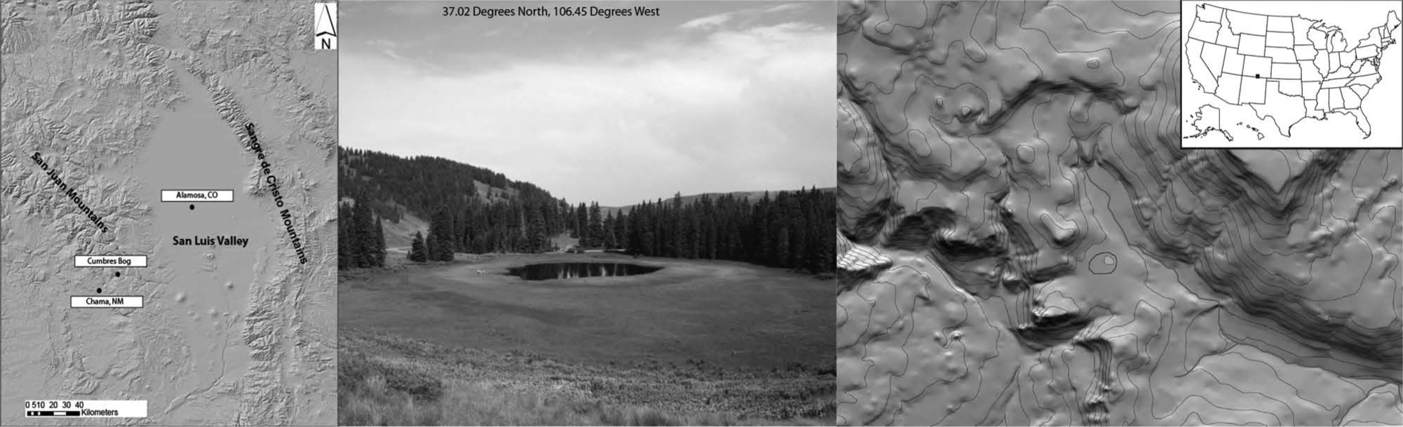
Cumbres Bog lies at 3050 m and is ~150 m across with 50 m of open water in the middle. The core was taken at the edge of the open water. The bog lies perched above the Cumbres River in a drainage basin only slightly larger than the bog itself. The small tree-lined ridge to the right of the bog is 2–4 m high and composed of glacial sediments. The sedimentology, along with Atwood and Mather’s mapping (1932), leads us to interpret the ridge as either a recessional moraine or as part of the right lateral moraine.
Modern vegetation in the San Juan Mountains is characterized by Pinus edulis (Colorado piñon) – Juniperus monosperma (one-seed juniper) woodlands that occur on the lower slopes of the range from ~1800 to 2400 m. An upper montane coniferous forest, from ~2400 to 2700 m, features Pseudotsuga menziesii (Douglas fir), Abies concolor (white fir), Pinus strobiformis (southwestern white pine), Pinus ponderosa (ponderosa pine), Picea pungens (Colorado blue spruce), Populus tremuloides (quaking aspen), Quercus gambelii (Gambel oak) and Acer glabrum (Rocky Mountain maple). Above 2700 m, a subalpine coniferous forest occurs with Picea engelmannii (Engelmann spruce) and Abies lasiocarpa (subalpine fir) as the most diagnostic trees. Vegetation above ~3500 m (treeline) is characterized by alpine tundra, dominated by compact low-growing perennials.
Cumbres Bog (37°1′18″N, 106°27′W) lies at 3050 m a.s.l. (~ 500 m below modern treeline) and is surrounded by subalpine coniferous species (Weber, 1976). The bog is ~ 150 m across with a ~50 m diameter section of open water (Figure 1). Areas that are not open water are covered in ~4 m of peat, which forms a floating mat covering the majority of the bog’s surface. The basin is elevated (4–5 m) above the Cumbres River (~ 200 m north) and no significant channels flow into Cumbres Bog. The current depth of the bog, from surface to the top of the sediment, is ~5 m although historical depths would have been as great as 12 m.
Methods
We extracted a core from Cumbres Bog using a square piston rod Livingstone corer with a Bolivia adapter that extended 12 m from the surface. Livingstone corers are ideal for extracting soft sediments without disturbing the stratigraphy, and the Bolivia adapter allows sediments to be sampled directly into 1 m polycarbonate tubes, which eliminates disturbance associated with extrusion (Livingstone, 1955; Mayle et al., 2000). Our core displays intact horizontal laminations indicating very little disturbance of sediment during extraction. During coring, the first 4 m extracted were unconsolidated peat, followed by 1 m of open water, and then 7 m of fine, soft sediment preserved as a core. The core was extracted in polycarbonate tubes and shipped to the LacCore facility at the University of Minnesota where they were split, subsampled, and described. Samples were collected for particle size analysis and percent organic matter (OM) at 2 cm intervals (16–97 years), pollen at 10 cm intervals (43–494 years), and diatoms at 20 cm intervals (111–956 years). Percent OM was determined via loss-on-ignition at 550°C (Dean, 1974). Particle size was examined using a Spectrex laser particle counter. Organic material was collected at seven intervals from the core for radiocarbon dating at the Center for Applied Isotope Studies at the University of Georgia (Figure 2). Identifiable organic materials (i.e. sticks, leaves) were dated when possible although bulk sediment was dated in clastic rich sections where individual organic materials could not be isolated. Magnetic susceptibility (MS) was measured using a Geotek XYZ split core high-resolution logger. Pollen was separated using the method described in Faegri and Iversen (1989) and was identified to the lowest taxonomic level possible by comparing the fossils with their present-day relatives using published keys. Pollen percentages, excluding the aquatics (mostly Cyperaceae), were calculated as well as ratios of Pinus/Artemisia (Pi−A/Pi+A) and Picea/Artemisia (P−A/P+A). Diatoms were extracted by treating samples with cold 10% hydrochloric acid and 35% hydrogen peroxide (Battarbee, 1986) and mounted for microscopic analysis in Zrax (a permanent high-relief mounting media). Diatoms were identified to genus; when possible, at least 300 valves were identified per sample. Time-series analysis was completed on annualized data from each proxy using the statistical package JMP 9.0 which uses a Fourier Transform to identify dominant periodicities within the data.
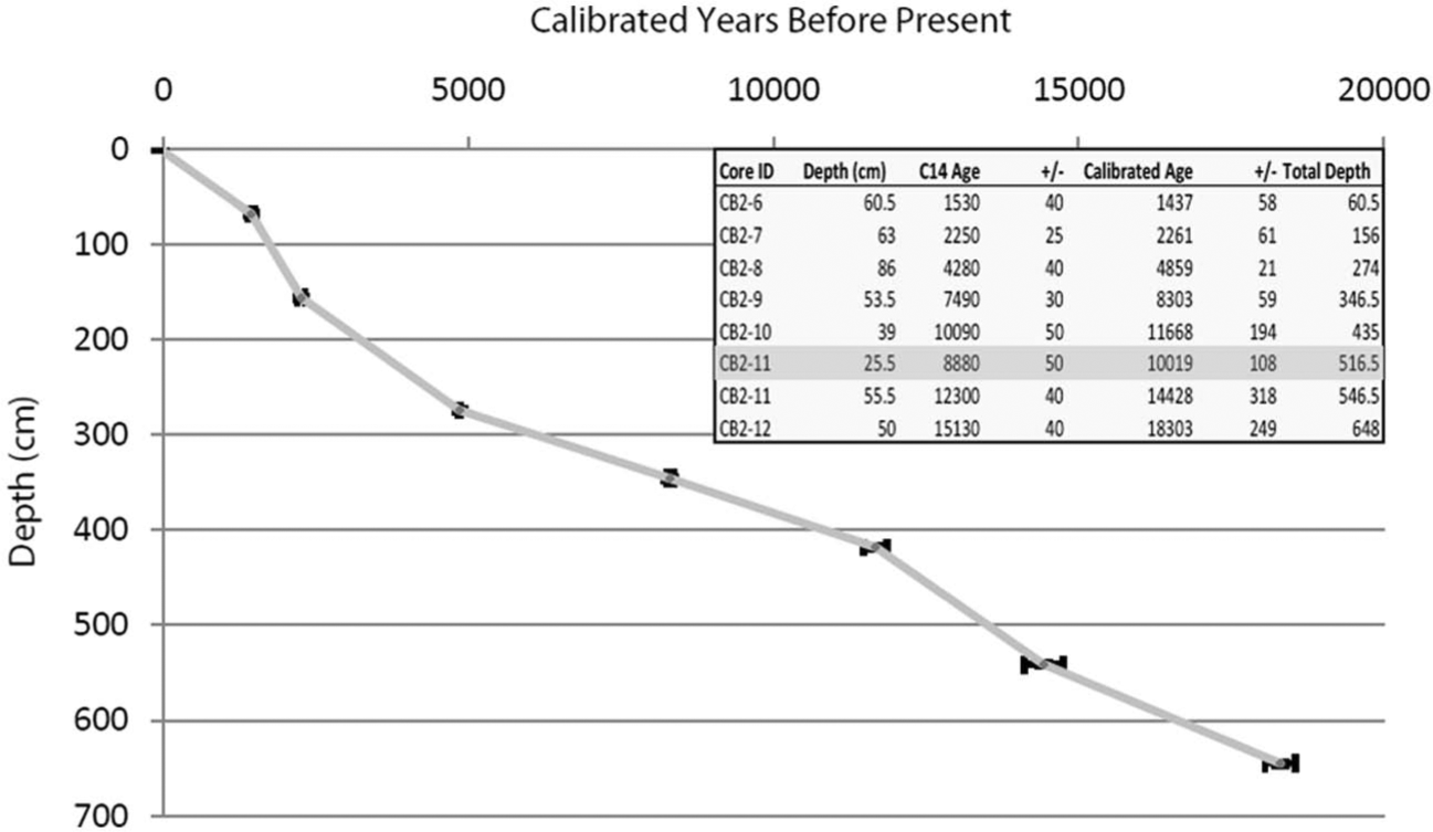
Age model for the Cumbres Bog core, San Juan Mountains, Colorado. It consists of seven radiocarbon dates and the inference that the top of the core is modern. Raw and calibrated ages are presented along with one sigma errors. Depth refers to the depth within the individual drive and total depth is measured from the top of the sediment. Dated materials are as follows: CB 2-6: stick; CB 2-7: stem; CB 2-8: leaf; CB 2-9: bulk sediment; CB 2-10: peat; CB 2-11: bulk sediment; and CB 2-12: bulk sediment. The highlighted age was not used in the creation of the age model as subsequent cores showed that it had been sampled from an interval of recore. Samples were analyzed at the University of Georgia Center for Applied Isotope Studies.
Alpine treeline is sensitive to temperature and length of the growing season (Cairns and Malanson, 1998). Migration of the treeline species, as recorded in percentage variations of arboreal pollen in alpine lake records, can be an indicator of temperature change. Several studies from the southern Rocky Mountains (Carrara et al., 1984, 1991; Jiménez-Moreno and Anderson, 2013; Jiménez-Moreno et al., 2008, 2011; Markgraf and Scott, 1981; Reasoner and Jodry, 2000; Toney and Anderson, 2006) have used this relationship to document Holocene treeline fluctuations. We interpret periods of high Pinus/Artemisia ratios to indicate relatively warm periods when pine, which currently grows at elevations much lower than Cumbres Bog, was able to encroach on the bog from the valley below. During relatively cold periods, Pinus would have migrated downslope below the elevation of the pond. On the other hand, Artemisia could have increased because of an expansion of tundra in areas around the bog, a decrease in forested areas, and/or an increase in long distance transport from much lower elevations (steppe vegetation belt, Fall, 1997). These changes could result in low Pinus/Artemisia ratios. Similarly, low Picea/Artemisia ratios indicate periods when Artemisia was dominant over Picea in the pollen spectra. Thus, high values in both of the pollen ratios are proxies for warmer temperatures.
Diatoms are a microscopic golden-brown algae that create a siliceous test, commonly found in lacustrine habitats. Diatoms have been shown to be highly sensitive to a variety of environmental variables, including water chemistry, physical properties of water, nutrient status, and changes in habitat with lake depth and the thermal structure of lakes in response to climatic changes (Saros et al., 2012; Smol and Stoermer, 2010). Here we infer genus-level changes in the proportion of planktonic and benthic diatom assemblages from the record to indicate broad indication of changes in depth. These inferences are made particularly where a substantially higher proportion of planktonic species indicates that the modern bog was considerably deeper in the past. Cooler periods are inferred from early portions of the record where small colonial fragiariod species dominated, suggesting low-nutrient conditions and more substantial ice cover (Lotter and Bigler, 2000). This information has been coupled with changes in the planktonic species downcore that indicate substantial changes in nutrient influx and changes in the relative proportion of meroplanktonic and euplanktonic genera to indicate deviations in the thermal structure, where a higher proportion of meroplanktonic species suggests deeper lake mixing, based upon known modern autecological preferences (Jewson, 1992; Saros et al., 2005, 2012).
Results and discussion
Age model
The age model is a linear interpolation based on seven radiocarbon dates (Figure 2), extrapolated before 18.3 cal. kyr BP to include ~20 cal. kyr BP years of sediment deposition. One additional outlier date was excluded from the age model. Sedimentation rates in Cumbres Bog remained between 0.2 and 0.4 mm/yr for six of the seven intervals bracketed by our age data. The sedimentation rate of the remaining interval, between 2.3 and 1.4 cal. kyr BP, was 1 mm/yr. All ages presented here are calibrated years BP (1950). Ages were calibrated using CalPal (Danzeglocke et al., 2012, accessed).
Sedimentology
Sediment at the base of the core (690 cm depth) contained pebbles embedded in clay. From 690 (the base of the core) to 660 cm depth (20–18.8 cal. kyr BP), rhythmically bedded laminations occur (Figure 3), alternating between light-colored fine sediment (mostly clay) and darker-colored coarse sediments (mostly sand). Within individual lamina, coarse sediment packages typically grade upward into the fine sediment packages, whereas fine sediment packages typically have abrupt contacts with the overlying coarse lamina. We believe these rhythmites may be varves, although we determined that they were not definitive enough to alter the extrapolated age model. Between 660 and 630 cm (18.8 to 17.6 cal. kyr BP), the sediment comprises laminated, interbedded clay and silty-clay ranging in color from gray to slightly brown. Between 630 and 580 cm depths (17.6 to 15.7 cal. kyr BP) laminated clays transition upward into unlaminated gray clays before returning to weakly laminated clays between 580 and 540 cm (from 15.7 to 14.3 cal. kyr BP). From depth 540 to depth 518 cm (14.3 to 13.7 cal. kyr BP), sediment is composed of thickly bedded, slightly organic-rich clays, which are darker than the gray clays described above. Between depths 518 and 510 cm (13.7 to 13.5 cal. kyr BP), sediment is composed of organic-rich muds similar to those deposited after 11.8 cal. kyr BP (see below). Slightly organic-rich mud is present between 510 and 502 cm depth (13.5 to 13.2 cal. kyr BP) while the section between 502 and 490 cm depth (13.2 to 13.0 cal. kyr BP) is organic-rich muds. Sediment between 490 and 438 cm depth (13.0 to 11.8 cal. kyr BP) is composed of unlaminated, slightly organic clay (Figure 3). From depth 438 (11.8 cal. kyr BP) through the remainder of the core (depth 0 cm, −54 years), the sediment is characterized by laminated organic-rich muds interbedded with unlaminated organic-rich clays. In the upper part of the core, large pieces of intact detrital OM (e.g. leaves, sticks, and seeds) are common. Higher content of OM together with gray sediment suggests a consistently low-oxygen environment of deposition. Parts of the core exposed to oxygen (i.e. the ends of the core) rapidly oxidize and change color to yellow or red.
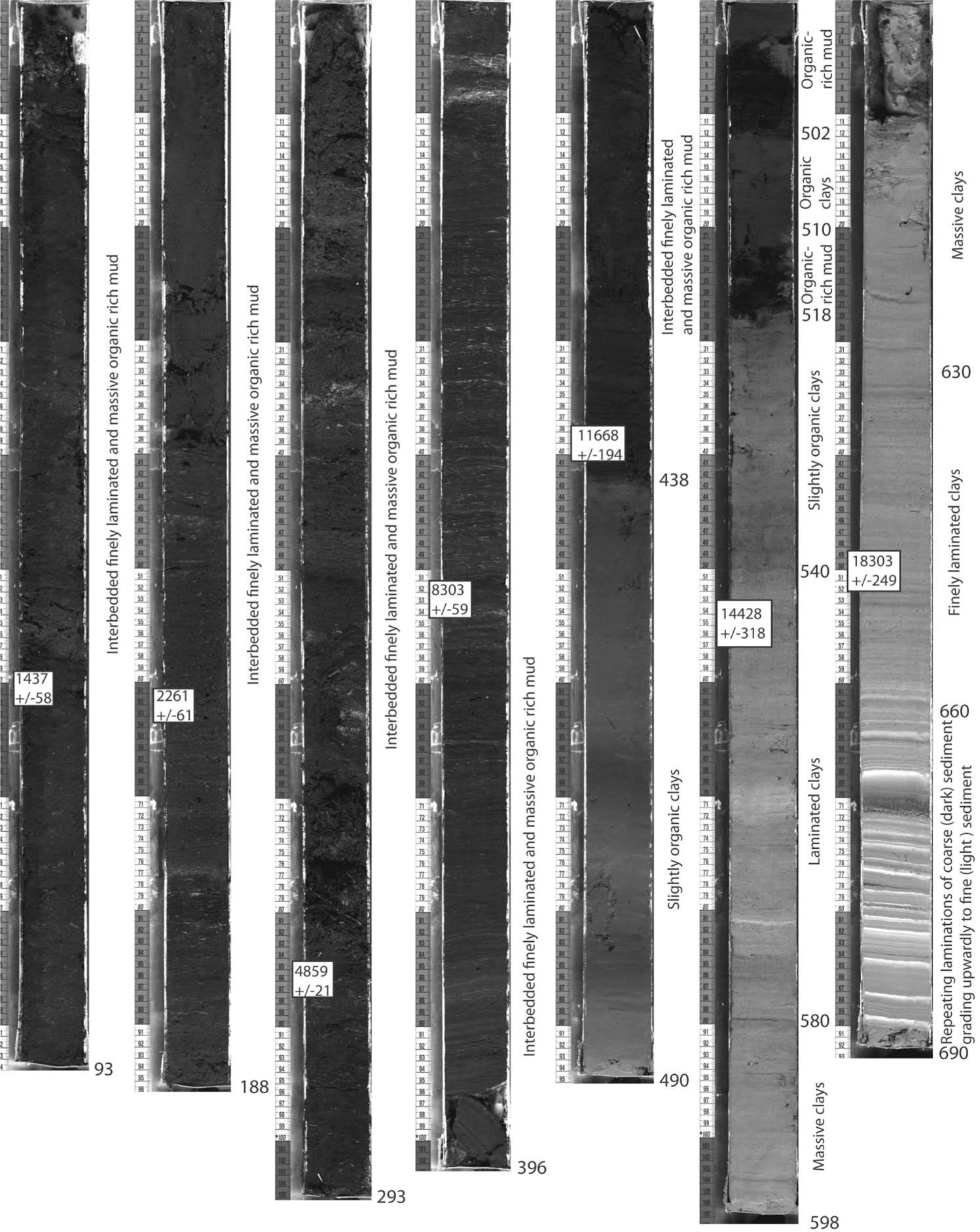
High-resolution images taken of the Cumbres Bog Core. Cumulative depths and sediment descriptions are labeled along the core. Calibrated radiocarbon dates with estimated errors are shown from sample location.
The record of climate change
Pebbles at the base of the core combined with the bog’s proximity to a terminal moraine complex (Atwood and Mather, 1932), indicates that the catchment was still glaciated at ~20 cal. kyr BP, which correlates with other studies in the San Juan Mountains (Guido et al., 2007) and the intermountain West (Benson et al., 2005). The Lateglacial interval is characterized by low arboreal pollen (AP; Figure 4), Picea/Artemisia (−0.7 to −0.92) and Pinus/Artemisia (< 0) ratios implying significantly colder average temperatures than the rest of the record (0.22 to −0.8 and −0.2 to 0.8, respectively (unitless ratios); Figure 5). Relative warming, indicated by a gradual rise in arboreal pollen and in the pollen ratios, began at ~18 cal. kyr BP, punctuated by an abrupt, transient interval of much warmer conditions centered around ~15.5 cal. kyr BP. The absence of fossil diatoms prior to ~17 cal. kyr BP (Figure 6) suggests a very low-nutrient and/or turbid water environment. Benthic and small colonial tychoplanktonic fragilarioid diatoms became a significant component of the sediment after ~16.5 cal. kyr BP (Figure 6), suggesting increased water transparency as a result of reduced glacial inputs or potentially a slight increase in nutrient influx as a result of soil development within the catchment basin (Engstrom and Fritz, 2006). These small colonial fragilarioid species are common in alpine settings with cool, low-nutrient conditions and at least intermittent ice-free periods (Lotter and Bigler, 2000). During the relatively cold postglacial period (20–14 cal. kyr BP), the percent OM was the lowest in the core, but values increased along with temperature during the Allerød interstadial (14–13 cal. kyr BP; Figure 5). Sediment deposited in the bog between 20 and 13 cal. kyr BP is characterized by clay-rich layers interbedded with sandy silt. MS is highly variable during this period, with values ranging from 0 to 300 (SI units). Around 14.5 cal. kyr BP (and again corresponding with the Allerød interstadial), the fossil diatom assemblages undergo a major shift toward a planktonic species (Figure 6), more characteristic of lake conditions than those of a shallow bog, suggesting warmer conditions than the previous interval, with phosphorus-rich waters and significant ice-free periods (Kilham et al., 1996; Lotter and Bigler, 2000; Lotter et al., 1998). Diatoms suggest peak Pleistocene temperatures occurred around 13.5 cal. kyr BP, when the assemblage briefly shifted toward planktonic (free-floating) fragilarioid species (Figure 6), commonly associated with stronger thermal stratification (Saros et al., 2005) and higher silica and lower phosphorus requirements, suggesting some soil development in the basin may have begun to sequester phosphorus (Norton et al., 2011). Around ~12.5 cal. kyr BP, the fossil plankton assemblage begin to be replaced by small colonial tychoplanktonic fragilariod species again, suggesting a return to cooler conditions with longer ice cover (Lotter and Bigler, 2000).
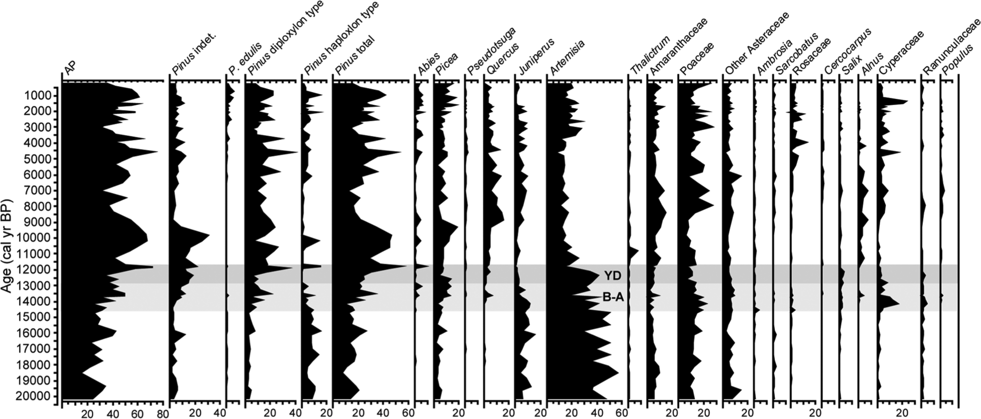
Pollen diagram from Cumbres Bog showing percentages of selected taxa. Aquatics (Cyperaceae) were excluded from the pollen sum. B-A and YD refer to Bølling-Allerød and Younger Dryas, respectively.
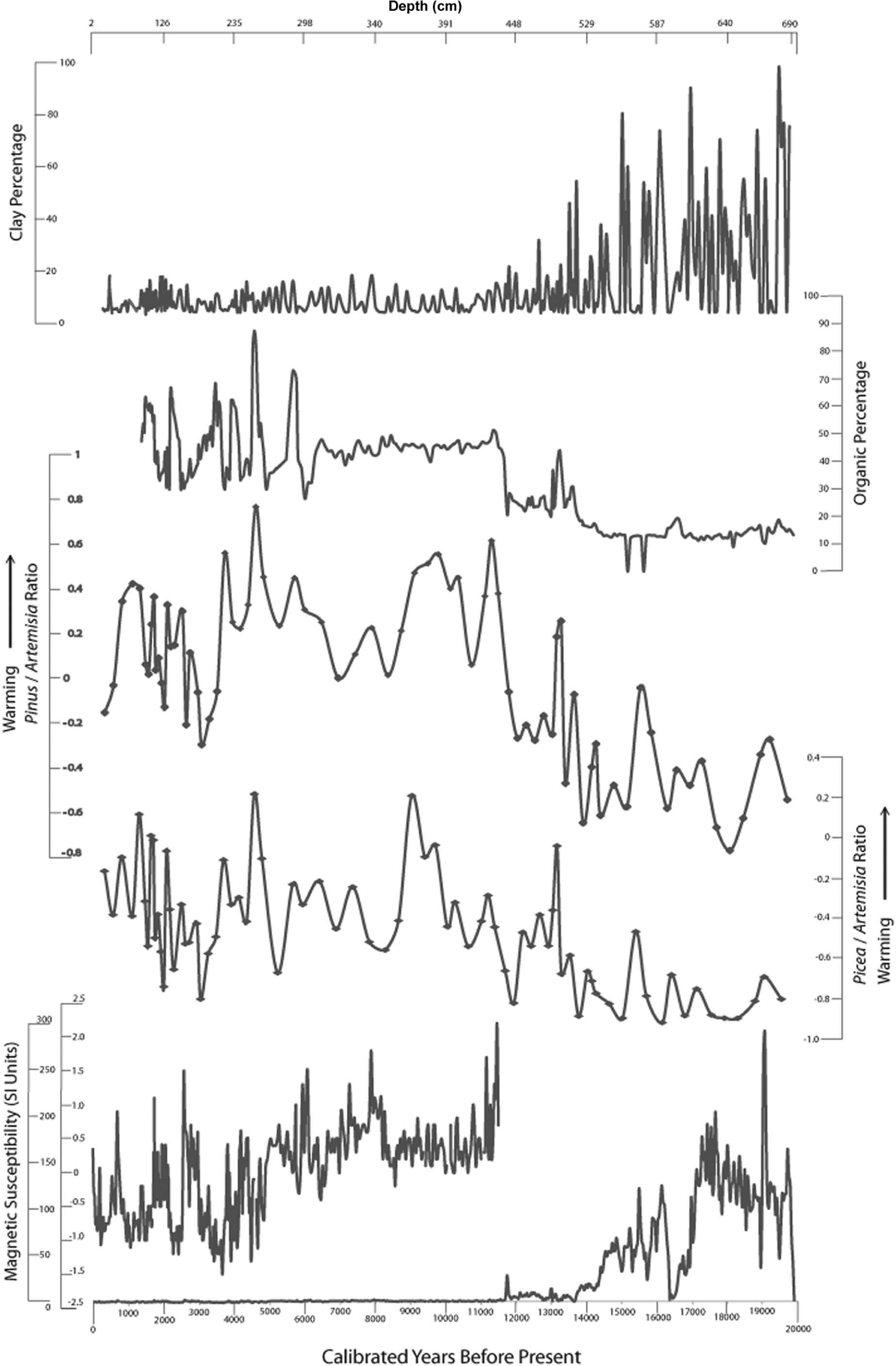
Paleoclimate proxy data from Cumbres Bog. Increases in climate proxy frequency noted in the text can be seen in pollen ratios (calculated as Pinus/Artemisia (Pi−A/Pi+A) and Picea/Artemisia (P−A/P+A)) after 6 cal. kyr BP and again after 3.5 cal. kyr BP.
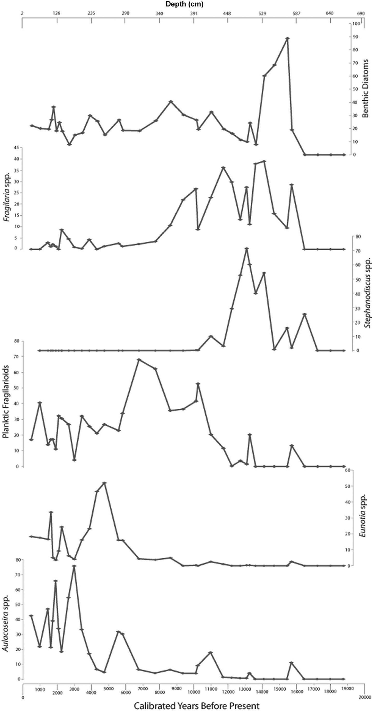
Diatom stratigraphy of Cumbres Bog. Major diatom groups are displayed in relative percent abundances.
The Younger Dryas (YD; 12.8–11.5 cal. kyr BP) is evident in the record, with temperatures generally warmer than during deglaciation but still cooler than the Holocene and Allerød interstadial (Figure 5). Increased Picea/Artemisia and Pinus/Artemisia ratios, as well as a switch to thermocline-associated plankton, indicates significant warming immediately after the YD (Saros et al., 2005). This period of warming is marked by an abrupt transition from clastic-dominated sediment to organic-dominated sediment. The increase in organic materials is distinct and important because it likely indicates a threshold whereby the bog is a consistently more biologically productive environment after 11.5 cal. kyr BP. The magnetic susceptibility varies significantly less after the YD with values varying between −2.5 and 2.5 (SI units) during the Holocene compared with values between 0 and 300 (SI units) during the Pleistocene. The correspondence between the shift in MS data and the temperature swing shown in the pollen data imply that this regime shift is due to the crossing of a temperature threshold for productivity and not coincidental in-filling of the bog. Pollen indicates there is one additional cold period before the Holocene at 10.6 cal. kyr BP. The fossil diatom record during this cold period is dominated by small fragilarioid diatoms, suggesting a short ice-free period. By 11.5 cal. kyr BP, this assemblage gradually begins to be replaced by plankton associated with lake settings and the development of a strong thermocline, suggesting warm, wet conditions.
Picea/Artemisia and Pinus/Artemisia ratios indicate cold temperatures during numerous intervals of the Holocene, including: 8.7–7.9, 7.0–6.9, 5.4–5.2, 4.1–3.8, 3.3–3.0, 2.3, 2.0 and 1.5 cal. kyr BP (Figure 5). Between 10 and 6 cal. kyr BP these cold periods appear to have had very little impact on organic content, implying that aquatic biologic productivity was relatively constant despite changes in climate and vegetation on adjacent slopes. The fossil diatom record for the early Holocene is increasingly dominated by plankton that thrive in open, thermally stratified water, matching the rise in temperature typically associated with the transition into the mid Holocene. Cooler periods during the Holocene are suggested by the repeated transitions in dominance by Aulacoseira species which require completely mixed water (Figure 6, Fritz et al., 1990; Jewson, 1992; Kilham et al., 1996). After 6 cal. kyr BP, periods of cold temperature generally correlate with periods of low percentages of organic matter (i.e. at ~ 5.2, 4.0, 3.0, 2.0, and 1.5 cal. kyr BP) although rapid transitions during the period make it difficult to make direct correlations. By ~5 cal. kyr BP, the fossil diatom record indicates a gradual change in water level, transitioning to shallower and more acidic, bog-like, benthic-dominated conditions. Throughout the late Holocene, periods interpreted as cool are often represented in the diatom record as a shift toward Aulacoseira dominance and warmer periods as a shift toward Eunotia dominance, suggesting frequent and often abrupt transitions in water depth (Fritz et al., 1990; Wolin and Stone, 2010). Clay content was relatively steady during the entire Holocene.
The data indicate that not only did climate vary significantly during the Holocene, the frequency of change appears to increase significantly after 6 cal. kyr BP and again after 3.5 cal. kyr BP (Figures 4 and 5). The changes in periodicity are visible in the pollen ratios and diatom data which display the following evolution of climate: between 11.5 and 6 cal. kyr BP a weak periodicity of 2700 years was present, between 6 and 3.5 cal. kyr BP a strong periodicity of 1100–1200 years was present, and between 3.5 and 0 cal. kyr BP a weak periodicity of ~400 years was present. This evolution is confirmed by frequency analysis which shows the development of periodicities of ~1200 and ~400 after 6 cal. kyr BP (Figure 7) although the 400 year periodicity may be an artifact of periodicities below the sampling interval. Additionally, the magnitude of climate variability before 6 cal. kyr BP appears moderated when compared with climate after 6 cal. kyr BP, which is characterized by higher and lower peaks in pollen ratios. To ensure that this increase in frequency was real and not an artifact of the increasing sedimentation rate with depth, pollen ratios were re-sampled at even intervals (~200 years). The interpolated resampling was then run through the same frequency analysis with the same ~400 year, 1100–1200 year, and weak 2700 year periodicities present. The re-sampling test eliminates the possibility of a false 400 year periodicity created by the initial sampling interval but not the possibility that the 400 year periodicity is an artifact of periodicities below the sampling interval. Nonetheless, it is important to note that peaks in the pollen ratios after 3.5 cal. kyr BP tend to be roughly 400 years apart.

Frequency analysis for the two pollen ratios (see Figure 5) presented as the relationship between periodicity (P=1/frequency) and spectral density. Between 11.5 and 6 cal. kyr BP the only notable periodicity is between 2700 and 3000 years. However, between 6 and 0 cal. kyr BP additional periodicities occur including one at ~ 1200 years and others below 500 years. We interpret these new periodicities to be the result of increased climate variability after 6 cal. kyr BP (~1200 yr periodicity) and again after 3.5 cal. kyr BP (~400 yr periodicity, see Figure 4). These finer frequencies appear to be overprinted on the underlying periodicity of ~3000 years.
Comparisons with other records
Regional records
The Allerød interstadial is represented in our core (519–490 cm depth, ~13.7–13.0 cal. kyr BP) by an isolated interval of organically dominated sediment suggesting that the final stages of LGM warming was rapid and of significant magnitude in the southern San Juan Mountains.
Previous records in the region (Armour et al., 2002; Benedict, 1973; Carrara and Andrews, 1976; Carrara et al., 1984, 1991; Elias et al., 1991; Feiler et al., 1997; Guido et al., 2007; Jiménez-Moreno et al., 2008; Markgraf and Scott, 1981; Miller, 1973; Reasoner and Jodry, 2000; Refsnider and Brugger, 2007; Vierling, 1998) suggest that the climate was generally cold until 10 cal. kyr BP, after which it was stable and warm until 6 cal. kyr BP and cold again thereafter (Figure 8). Our continuous temperature inferences show a similar pattern to the discontinuous records, but display significantly greater climate variability, highlighting the strengths of continuous records to capture abrupt climate transitions at a higher resolution. Regionally, the Cumbres Bog record is the first to reconcile cool temperatures inferred from continuous records (Feiler et al., 1997; Jiménez-Moreno et al., 2008) with rapid bursts of cold temperature observed in discontinuous records (Armour et al., 2002; Benedict, 1973; Miller, 1973; Refsnider and Brugger, 2007, Figure 8). The Cumbres Bog record’s rapid shifts in climate are consistent with discontinuous glacial and periglacial records that show brief periods of late-Holocene glacial re-advance (Benedict, 1973; Miller, 1973; Refsnider and Brugger, 2007) and likely add resolution to existing continuous records. More globally, with the exception of the last 2.5 cal. kyr BP, the Cumbres Bog record corresponds closely with periods of rapid climate change that had a widespread influence on global climate patterns identified by Mayewski et al. (2004).

A summary of postglacial paleoclimate records from the southern Rocky Mountains. Locations of the records are as follows: (1) San Juan Mountains, Colorado, (2) Sawatch Mountains, Colorado, (3) Elk and Sawatch Mountains, Colorado, (4) Sangre de Cristo Mountains, New Mexico, (5) San Juan Mountains, Colorado, (6) Elk Mountains, Colorado, (7) San Juan Mountains, Colorado, (8) Front Range, Colorado, (9) White River Plateau, Colorado, (10) Front Range, Colorado, (11) Front Range and San Juan Mountains, and (12) Sangre de Cristo Mountains, New Mexico. Records show a general trend of cool temperatures through the end of the Pleistocene followed by warm, stable temperatures from 10 through 6 cal. kyr BP. The period after 6 cal. kyr BP is characterized by generally cool temperatures and periods of glacial or periglacial activity locally. The record presented here identifies significant cooling during the Younger Dryas and additional complexity after 6 cal. kyr BP which is characterized not by one single cold period but by numerous intervals of cold temperatures. This explains why previous authors have identified glacial advances during the second half of the Holocene which are episodic in nature.
Younger Dryas
Both Cumbres Bog pollen ratios indicate a warming trend from 13.9 to 13.3 cal. kyr BP (four data points) followed by a cool period that lasted from 13 to 11.5 cal. kyr BP (six data points), which correspond to the currently accepted timing for the YD (12.9–11.7 cal. kyr BP, Broecker et al., 2010). The YD period is also highlighted in the core by a substantial decrease in organic content that likely indicates a period of lower productivity in and around the bog. Sedimentation may also have increased during the YD represented by a small rise in magnetic susceptibility during the interval.
Previous authors working in the region have identified evidence of a strong YD in the Rocky Mountains (e.g. Gosse et al., 1995; Reasoner and Huber, 1999). More locally, Reasoner and Jodry (2000) found downslope displacement of timberline in the Front Range during the YD and Cisneros-Dozal et al. (2010) noted reduced terrestrial productivity in northern New Mexico. However, in the Sangre de Christo Range, only subtle evidence of the YD was found (Jiménez-Moreno et al., 2008). The Cumbres Bog record is generally consistent with regional records and suggests a definitive YD that significantly influenced both vegetative patterns as well as productivity in and around the bog.
8200 year event
Both pollen indices show a dip between high temperatures in the earliest Holocene (10–9 cal. kyr BP) and warming after 8.2 cal. kyr BP that correspond with the 8200 year event caused by freshwater drainage into the North Atlantic (Hoffman et al., 2012; Li et al., 2012). The Picea/Artemisia ratio displays the dip more dramatically, with relatively cool temperatures from 8.8 cal. kyr BP to 7.9 cal. kyr BP (three data points) and a large magnitude decrease from the peak at 9.1 cal. kyr BP. The Pinus/Artemisia ratio shows a less dramatic change, with a big drop from 9.1 cal. kyr BP to the trough at 8.4 cal. kyr BP but less recovery after 8.4 cal. kyr BP (one data point) and a similar dip soon afterward at 7 cal. kyr BP. Organic content does not show a reduction in productivity similar to the one produced during the Younger Dryas. MS values at 8.0 cal. kyr BP are similar to those in the latest Pleistocene and may indicate increased sedimentation during the interval but the scale of this sedimentation would be very small compared with sedimentation before 12 cal. kyr BP. Increased sedimentation during the interval is supported by recent research examining sedimentation in the nearby Conejos River valley (Johnson et al., 2011; Layzell et al., 2012).
While the 8200 year event has been recorded in eastern North America (e.g. Kneller and Peteet, 1999; Shuman et al., 2002), the northern plains (e.g. Dean and Schwalb, 2000), western Canada (e.g. Menounos et al., 2004; Seppä et al., 2003), and Alaska (e.g. Mason et al., 2001), the Cumbres Bog record would be rare evidence of the event in the southern Rocky Mountains. In fact, no 8200 year anomaly is evident in the relatively proximal Sangre de Cristo Mountains (Jiménez-Moreno et al., 2008). The small magnitude of the event in the Cumbres Bog core may indicate that the local dip in temperature merely coincides with the 8200 year event and it is difficult to assess what forcing mechanism would have been working in the area at the time.
Comparison with ENSO records
The increase in the frequency of climate variability in the Cumbres Bog core during the Holocene can be compared with the timing of changes to regional forcing mechanisms to examine possible connections. In the Cumbres Bog core, the first change in periodicity occurs at around 6 cal. kyr BP. For example, the periodicity of the pollen record changes from 2000–3000 yr to 700–1100 at 6 cal. kyr BP while organic content goes from very little variability prior to 6 cal. kyr BP to high variability after 6 cal. kyr BP (with a 700–1100 yr periodicity). Similarly, a 6 cal. kyr BP change in organic content is marked by a switch from 35–55% organic content before to 25–90% afterwards. The periodicity of the magnetic susceptibility record also increases significantly at 6 cal. kyr BP. The Cumbres Bog 6 cal. kyr BP timing of frequency change coincides with published records showing an increase in the strength of ENSO in the mid Holocene (Menking and Anderson, 2003, 6.2 cal. kyr BP; Moy et al., 2002, 5 cal. kyr BP; Rodbell et al., 1999, 5 cal. kyr BP;Shulmeister and Lees, 1995, 4 cal. kyr BP) and as well as modeling results (Liu et al., 2000). After 3.5 cal. kyr BP, the Cumbres Bog pollen record again increases in frequency to 0.4 cal. kyr BP per period. The Cumbres Bog increase again coincides with records of ENSO activity (Moy et al., 2002). The similarities in timing are notable yet the correlation between the two records does not necessarily imply causation as it is difficult to assess the role that decadal variations in intensity of ENSO may have had on centennial-scale climate changes. Specifically, a lack of ENSO records from the southwestern USA combined with a lack of understanding about the development of the North American Monsoon makes understanding possible teleconnections difficult.
Nonetheless, it may still be useful to speculate about how increased ENSO strength over decadal timescales may lead to increased periodicity over longer timescales. In modern climates, ENSO warm phases (El Niño) increase winter precipitation in the San Juan Mountains while cold phases (La Niña) lead to warm, dry winters (NOAA El Niño Impacts; http://www.elnino.noaa.gov/impacts.html). Thus, a stronger ENSO cycle increases the interannual winter precipitation variability by providing alternating years of high magnitude, wet and dry winters. It is possible that during the Holocene, periods of strong ENSO warm phases led to increased spring and summer snowpack and cool, dry summers in the San Juan Mountains while periods of strong cold phase ENSO events led to warm winters and long, wet summers (e.g. Cayan, 1996). This could occur because low spring/summer snowpack may decrease albedo and allow convective heating during the monsoonal summer, thereby increasing precipitation. The resulting record would be characterized by short, intense periods of cold intermixed with intense periods of warm, wet conditions. Again, many factors cannot be taken into account in this discussion (including the development of the North American Monsoon) making it difficult to produce definitive results. A record focusing on the variability of precipitation, and not just temperature, during the Holocene would increase understanding of how ENSO influenced climate periodicity during the Holocene.
Conclusions
Our study provides a rare record of substantial climate variability in the southern San Juan Mountains since the onset of deglaciation. Between 20 and 14 cal. kyr BP, climate remained relatively stable and cool with the exception of a brief warm interval at 15.5 cal. kyr BP. Climate warmed significantly during the Allerød interstadial (13.7–13 cal. kyr BP), before rapid cooling during the YD (12.8–11.5 cal. kyr BP). After the YD, the climate generally warmed with colder periods occurring at 10.6, 8.7–7.9, 7.0–6.9, 5.4–5.2, 3.3–3.0, 2.3, 2.0 and 1.5 cal. kyr BP. The majority of these cold periods (7.0–6.9 cal. kyr BP excepted) correspond with previously published periods of rapid climate change (e.g. Mayewski et al., 2004). Results from the core are inconclusive during the last 400 years (corresponding with the ‘Little Ice Age’). Changes in the periodicity of climate variability during the Holocene imply that in addition to global climate changes, a regional climate forcing may also have impacted climate in the area. The timing of the periodicity change from 2000 to 3000 yr periods before 6 cal. kyr BP to 700–1100 yr periods after 6 cal. kyr BP, to ~400 yr periods after 3.5 cal. kyr BP matches well with published changes in ENSO strength (Rodbell et al., 1999).
Footnotes
Acknowledgements
Bog cores were split, sampled, and described at the LacCore facility. Thanks to Jake Armour and Joshua Link for field assistance. Thanks also to Vera Markgraf, Joe Mason, and an anonymous reviewer for feedback that significantly improved the manuscript.
Funding
The project was funded by grants from the UNC Charlotte Faculty Research Grant Program (MCE, JAD), the Colorado Scientific Society (BGJ), and Geological Society of America (BGJ). Additional support was provided by LacCore, the Fritz Laboratory (UNL), the Saros Laboratory (UMaine), the Chama Institute of Arts and Sciences.