
Abstract
Although the most crucial factor shaping vegetation history is temperature, snowfall regime is also important in regions of heavy snow. Pollen analysis in a mire in a snowy mountainous region of central Japan revealed histories of vegetation and precipitation regimes since the latest Pleistocene. The abundance of pinaceous pollen during the latest Pleistocene indicates a subalpine regional coniferous forest and cooler conditions; moreover, sandy sediment and significant occurrence of pollen from Artemisia along with several alpine elements suggest local plant communities of poor vegetation cover in an erosive environment. The increase in Betula and Quercus subgen. Lepidobalanus pollen and the decline in pinaceous pollen in 13,550 cal. yr BP indicates climatic amelioration favourable to temperate trees, and the invasion of sedges and Reynoutria to the small basin and the onset of peat deposition suggest an increase in summer rain. The increase in Fagus crenata pollen after 11,130 cal. yr BP and onwards indicates that the present heavy snowfall regime induced by inflow of the Tsushima Current has been established since that age. The climatic amelioration delayed establishment of the heavy snowfall regime for more than 2400 years. In addition, the retreat of sedges and subsequent invasion of several species of drier habitat after 11,130 cal. yr BP indicate a drier mire condition caused by increased summer temperatures. The recovery of sedges after 3740 cal. yr BP indicates the wettest mire conditions induced by climatic deterioration. A general increasing tendency of conifers in this period supports this interpretation.
Introduction
Quaternary vegetation changes have been determined primarily by temperature. In snow-rich regions, although this factor has played a crucial role, snowfall regime has also been important. Sea-level changes exceeding 100 m since the last glacial maximum have drastically altered current systems around the Japanese Archipelago (Gorbarenko and Southon, 2000; Oba et al., 1991) and have directly influenced snowfall regimes. The warm current in the Sea of Japan generates abundant water vapour, and the northwesterly winds of the winter monsoon bring heavy snow to the Japanese Archipelago. This fact implies that plant communities adapted to heavy snow conditions became established after the inflow of the warm current to the Sea of Japan. So far, no definitive snowfall reconstructions that cover the Holocene period are available for mid-altitudes, and so, the snowfall history is not yet well understood.
This paper presents a new approach for studying snowfall history. To explore the beginning of the current heavy snow conditions in central Japan, I highlighted changes in abundance of Fagus crenata pollen. The distribution of F. crenata-dominated forest is controlled by heavy snowfall, and such forests are prominent in the temperate montane forest zone on the Sea of Japan side of Japan, which experiences heavy snowfall (Bradshaw et al., 2010; Hara, 2010; Homma, 1997, 2001). Consequently, the beginning of regional F. crenata-dominated forests indicates the establishment of a heavy snowfall regime. Simultaneously, the local vegetation of small sedimentary basins is primarily controlled by local factors such as local hydrology, which is crucially influenced by precipitation (Yonebayashi, 1996, 2001)
In this study, pollen analysis and radiocarbon dating of core sediment from the Gakino-tanbo mire were used to clarify (1) the onset of the present snowfall regime from the formation history of regional F. crenata-dominated forest and (2) the precipitation history from changes in local mire vegetation.
Geographical setting and vegetation
Gakino-tanbo is a mire in the northern part of the Hida Mountains in central Japan (Figure 1; 36°40.80′N, 137°41.62′E, 1640 m a.s.l.). The mire in a small closed basin that was formed by a landslide is approximately 100 × 40 m in size and is situated on a ridge gently sloping towards the west (Sohma, 1991). There are several high peaks of about 2600–2900 m to the east of the mire and peaks of about 3000 m to the southwest. Through a gorge to the west, a river runs northwestwards to the Sea of Japan, descending more than 600 m in 35 km. This sea is remarkably warm in winter because of the Tsushima Current, which is a branch of the warm Kuroshio Current. The humid winter monsoon winds arrive over this sea and collide with the mountain ranges, subsequently climbing and bringing heavy snowfall to areas facing the sea, including the area around the mire. Cold, dry winds are also carried to the leeward Pacific side.

The Gakino-tanbo area, showing the location of the sampling site and other localities mentioned in this paper.
The study area is within the Chubusangaku National Park and is predominantly forested; hence, natural vegetation is well preserved. The mire is close to the uppermost extent of the montane beech forest zone. The forest around the mire includes F. crenata, Betula ermanii, Tsuga diversifolia and Pinus parviflora in the tree layer. Species such as Acer tschonoskii, Chengiopanax sciadophylloides, Sorbus commixta, Acer nipponicum, Sasa kurilensis, Viburnum furcatum, Reynoutria sachalinensis and Maianthemum dilatatum are common in the understory. The Gakino-tanbo is a sedge-Sphagnum mire which includes Carex blepharicarpa, Drosera rotundifolia and Lycopus uniflorus, and species such as Calamagrostis purpurea subsp. langsdorfii, Carex canescens, M. dilatatum and Osmundastrum cinnamomeum are found around the margin (Sohma, 1992, personal communication).
Methods
Core samples for investigating sediment depth, sequential inorganic contents and degree of decomposition were collected by Sohma with a Hiller-type peat sampler at 15 sites along a south-to-north transect (Sohma, 1991). In this study, core G-30, 30 m from the southern end of the transect, was used for pollen analysis. Subsamples of approximately 5-mm-thick deposits were sliced from the core at 5- or 10-cm-depth intervals for pollen analysis. They were prepared following a modified standard technique (Fægri and Iversen, 1989) and mounted unstained in glycerin jelly (Yonebayashi et al., 1993). Six peat samples taken from core G-30 were newly submitted for radiocarbon dating (Table 1). Radiocarbon dates are shown as calibrated ages (cal. yr BP based on OxCal13: Bronk Ramsey, 2009), unless they are quoted as 14C years (14C yr BP).
Radiocarbon dates from Gakino-tanbo, central Japan.
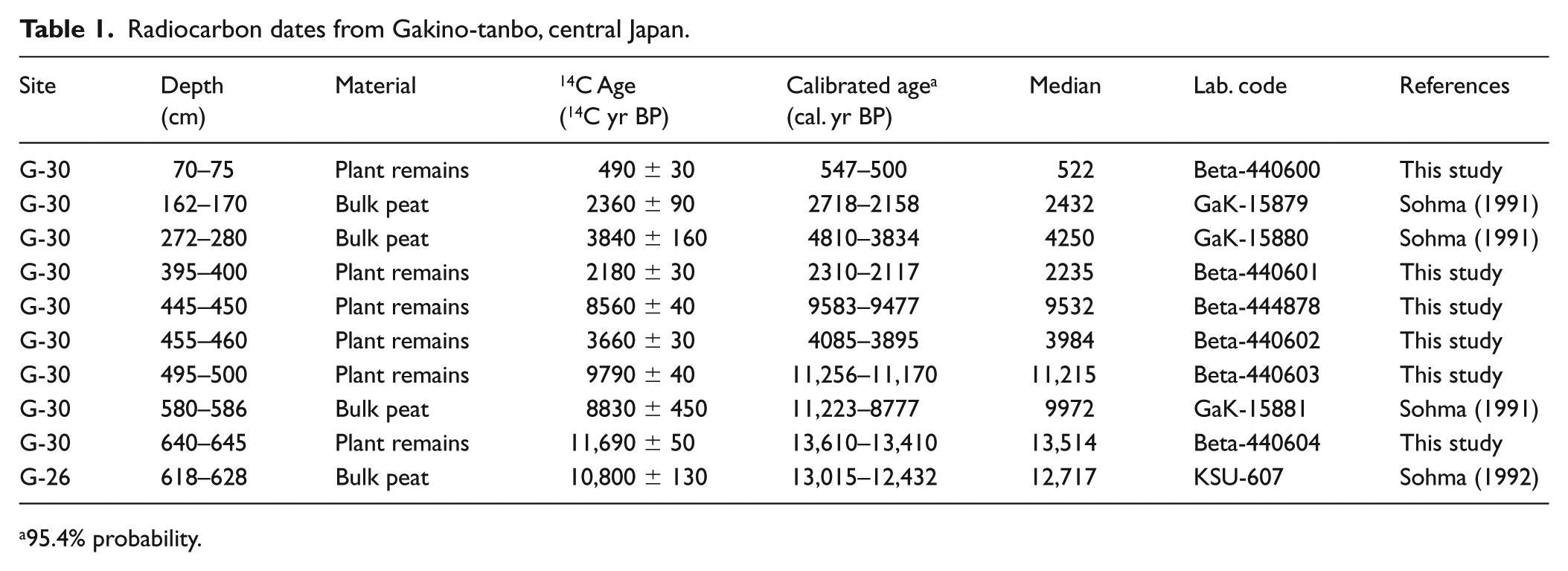
95.4% probability.
All pollen and spore grains were counted on evenly spaced transects on a cover slip until the total count of tree pollen grains exceeded 500 at a magnification of 400× or 1000× when necessary. The total count including non-tree pollen and spore types ranged from 749 to 6022 grains. Percentages of tree pollen types are expressed as a proportion of the total tree pollen count (Figure 2) to represent regional forest vegetation and to prevent pollen-prolific non-tree pollen and spore types from generating aberrations in the tree pollen percentages. Percentages of shrub and herb pollen types, fern spores and Sphagnum spores are expressed as a proportion of the total pollen count (Figure 3). Cupressaceae-type pollen consists of Cupressaceae, Taxaceae and/or Cephalotaxaceae pollen. Although Castanea-type pollen consists of Castanea, Castanopsis and/or Lithocarpus pollen, the upper distributional limits of the latter two genera are more than 1400 m lower than the study site.
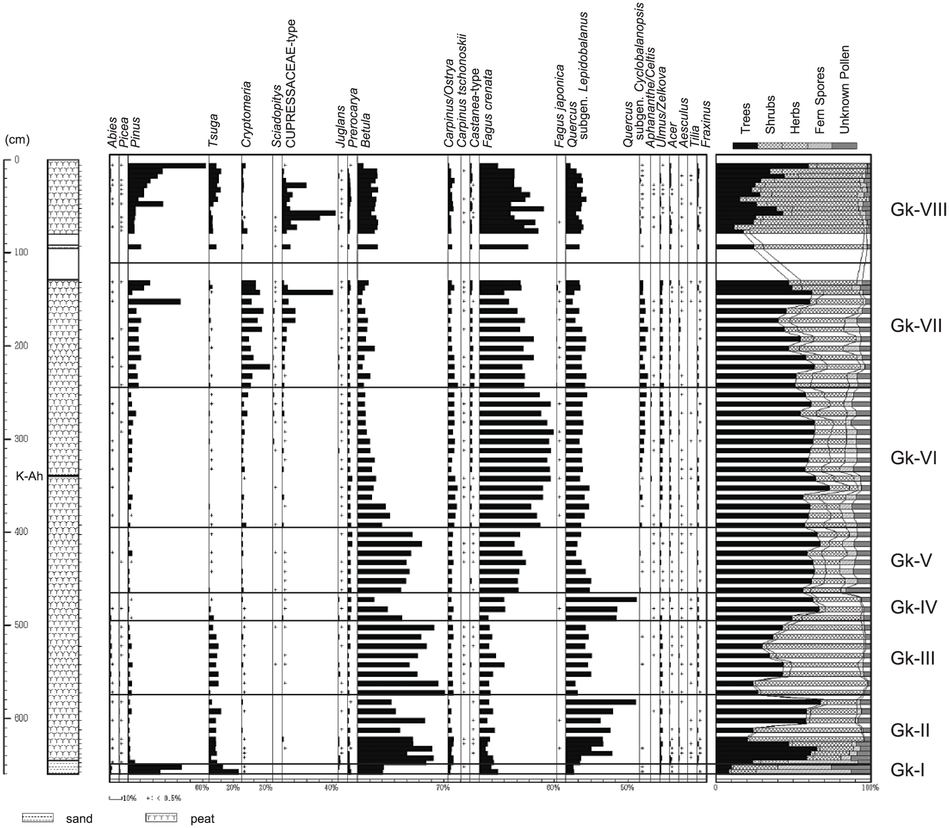
Pollen diagram of tree taxa of Gakino-tanbo, central Japan. Percentages are expressed as a proportion of the total tree pollen count. Plus signs in the diagram indicate less than 0.5%.
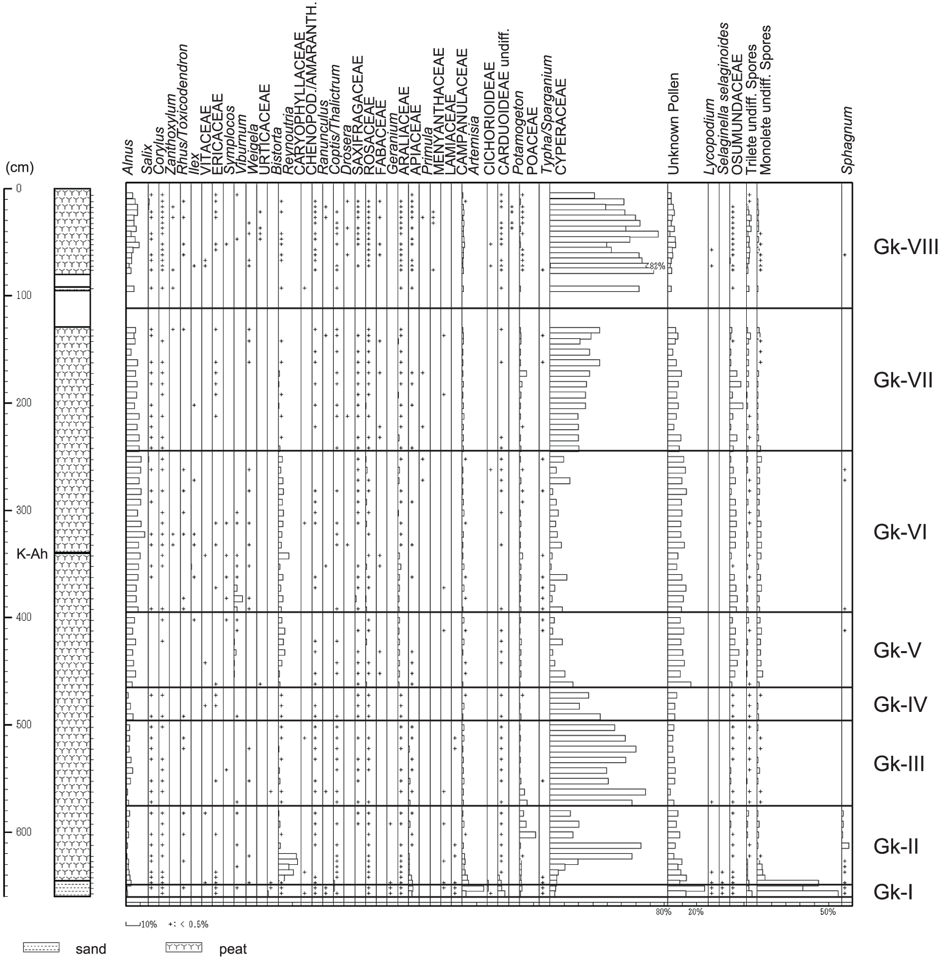
Pollen diagram of non-tree taxa of Gakino-tanbo, central Japan. Percentages are expressed as a proportion of the total pollen count. Plus signs in the diagram indicate less than 0.5%. Taxa occurred in more than three samples are exhibited.
Results
Sediments and radiocarbon dating
A columnar section of deposits is shown on the left of each pollen diagram (Figures 2 and 3). The core sample between 80 and 129 cm could not be retrieved except for around 92 cm because of superfluous groundwater. Peat prevailed through the entire core other than the lowermost 15 cm sand layer. According to Sohma (1991), this peat layer is divided into the following three parts:
645–500 cm: Inorganic content is relatively high, with inorganic content at some depths peaking at more than 10%. The proportions (dry weight %) of herbaceous remains (0.25–1 mm) are generally low (mostly 20–30%).
500–250 cm: Inorganic content is low (less than 5% except for levels around the Kikai-Akahoya tephra) at sites in the middle of the mire, whereas they are high at sites on the margins of the mire. The Kikai-Akahoya tephra (K-Ah), which is attributed to an eruption of the Kikai Caldera in the East China Sea, about 910 km to the southwest of the site in 7303–7165 cal. yr BP (Smith et al., 2013), is found at a depth of 340 cm. Woody particles larger than 1 mm are abundant.
250–0 cm: Inorganic matter is hardly detectable, even at sites on the margin, and herbaceous or Sphagnum remains are abundant, averaging about 50%.
A peat sample close to the peat bottom (640–645 cm) gave date of 13,610–13,410 cal. yr BP (Table 1).
Pollen diagrams
The pollen diagrams (Figures 2 and 3) were divided into eight local pollen assemblage zones based on the tree pollen sequences. The approximate ages of the pollen zone boundaries were determined by means of linear interpolation and extrapolation based on the six radiocarbon dates (medians) and the age of the K-Ah (Figure 4). Three dates of 2310–2117 cal. yr BP (395–400 cm), 4085–3895 cal. yr BP (455–460 cm) and 11,223–8777 cal. yr BP (580–586 cm) were rejected because they are anomalous.
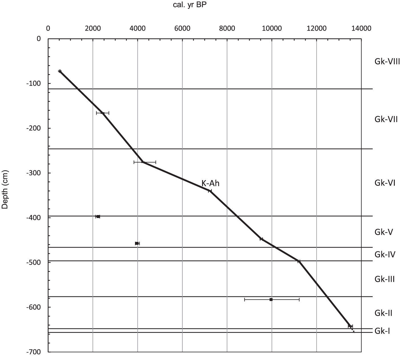
Relationship between sediment depth and age. Pollen zone boundaries were calculated by means of linear interpolation based on the six radiocarbon dates and the age of the K-Ah.
Gk-I: 655–650 cm (pre-13,550 cal. yr BP)
Co-dominance of Pinus, Tsuga and Betula pollen, which exceeded 70% of the total tree pollen count, characterized this zone, although tree pollen as a proportion of total pollen count was very low (8.5% and 10.1%). Only two tree pollen types other than these, Fagus crenata and Quercus subgen. Lepidobalanus (most Japanese species are deciduous), occurred to any remarkable extent. Among the non-tree pollen and spores, fern spores of monolete type were dominant (32.2% and 56.6% of total pollen and spores). Pollen of Artemisia and other Asteraceae occurred frequently, and pollen and spores of Ericaceae, Bistorta, Geranium, Apiaceae, Campanulaceae, Lycopodium and Selaginella selaginoides were clearly identified in this zone and at the beginning of the following zone.
Gk-II: 645–580 cm (13,550–12,440 cal. yr BP)
Among tree pollen, the percentages of Pinus and Tsuga pollen as well as Abies and Picea pollen fell compared with percentages in the Gk-I zone, whereas those of Betula and Q. subgen. Lepidobalanus pollen rose to dominance. Fern spores of momolete type declined abruptly after the lowermost sample of this zone. Percentages of Reynoutria pollen were high in the lower part of this zone, and Cyperaceae pollen rose to a peak of 60.4% in the midzone. Percentages of Poaceae pollen were high in the upper part of this zone.
Gk-III: 570–500 cm (12,440–11,130 cal. yr BP)
This zone was characterized by the dominance of Betula pollen and the retreat of Q. subgen. Lepidobalanus pollen. The proportions of non-tree pollen were high, which is attributed to the abundance of Cyperaceae pollen.
Gk-IV: 490–470 cm (11,130–10,120 cal. yr BP)
The percentages of Q. subgen. Lepidobalanus pollen increased again in response to the fall of Betula pollen. F. crenata pollen started to rise. Pinaceae (Abies, Picea, Tsuga and Pinus) pollen decreased, and Abies, Picea and Tsuga pollen was virtually absent by the end of this zone. Cyperaceae pollen declined upwards.
Gk-V: 460–400 cm (10,120–8410 cal. yr BP)
This zone was characterized by the co-dominance of Betula and F. crenata pollen, while Q. subgen. Lepidobalanus pollen decreased again and remained around 15% thereafter. The percentages of Cyperaceae pollen decreased further, and those of several non-tree pollen and spore types such as Reynoutria, Araliaceae, Osmundaceae and monolete fern spores increased.
Gk-VI: 390–250 cm (8410–3740 cal. yr BP)
The percentages of F. crenata pollen increased to dominance of 41.2–59.5% and Betula pollen decreased upwards. Pollen types of temperate conifers such as Cryptomeria, Sciadopitys and Cupressaceae-type as well as Quercus subgen. Cyclobalanopsis (evergreen oaks) started to rise after the K-Ah deposition. Pollen of Reynoutria and Araliaceae and fern spores of Osmundaceae and monolete type that rose in the previous zone remained with frequent occurrence, and the percentages of Cyperaceae pollen were still low.
Gk-VII: 240–129 cm (3740–1300 cal. yr BP)
There was further increase in the percentages of Pinus, Cryptomeria and Cupressaceae-type pollen. A slight rise in Tsuga pollen was also recorded. The percentages of F. crenata pollen declined slightly but were still quite high (mostly more than 30%). Although percentages of Reynoutria pollen and monolete fern spores fell, percentages of Osmundaceae spores remained considerable below the midzone. Cyperaceae pollen rose upwards again.
Gk-VIII: 92–3 cm (Post 1300 cal. yr BP)
Pinus pollen rose rapidly to the maximum of 62.5% at the uppermost sample. The percentages of Cryptomeria and Q. subgen. Cyclobalanopsis pollen declined. Cupressaceae-type and Tsuga pollen increased in abundance, though the former fluctuated intensely. Although a great abundance of Cyperaceae pollen was recorded again, it showed a declining tendency upwards.
Discussion
Vegetation history
The dominance of subalpine elements such as Pinus, Tsuga and Betula pollen in the Gk-I zone indicates that the pollen diagrams cover the period since the latest Pleistocene. The age close to the peat bottom (640–645 cm) was 13,610–13,410 cal. yr BP. This age does not conflict with an age of 13,015–12,432 cal. yr BP, which was obtained by Sohma (1992) from the peat bottom (618–628 cm) at site G-26, 4 m to the south (Table 1).
In the Gk-I zone, the percentages of Pinus, Tsuga and Betula pollen types were high, and pollen grains of Abies and Picea were present (0.9–1.8%), whereas the percentages of deciduous broad-leaved trees such as F. crenata and Q. subgen. Lepidobalanus were low (Figures 2 and 5). These observations suggest that subalpine coniferous forest was still abundant after the decline of dominant coniferous forest during the Last Glacial Maximum (Sekiguchi, 2001), even though low local pollen production due to poor vegetation cover in the mountains presumably caused pollen percentages of low altitude vegetation to be over-represented (Yonebayashi and Minaki, 1997). The forest probably included T. diversifolia, Abies mariesii, A. veitchii, Picea jezoensis var. hondoensis and Betula ermanii, all of which are observed in the present subalpine vegetation. Most pollen grains of the dominant Pinus in this zone were presumably derived from local Pinus pumila scrub on the lee slope of the small basin, although this genus includes several species with different ecological requirements. Absence of the upper subalpine P. pumila zone during the Last Glacial Age has been suggested on the assumption of reduced summer temperatures and decreased winter precipitation, but small communities of P. pumila were able to survive in unforested places such as mires and rocky fields (Okitsu, 1991; Okitsu and Ito, 1989). P. parviflora and P. koraiensis are also constituents of the present subalpine forest, and macrofossils of the latter species are commonly found in Japanese Last Glacial deposits (Sohma and Tsuji, 1987). Therefore, pollen grains from these species would also have been included. Pollen grains of Pinus subgenus Haploxylon that includes P. pumila, P. parviflora and P. koraiensis were actually detected from most samples (data are not shown). However, the results are difficult to assess, because subgenus identification of Pinus pollen largely depends on the orientation and differential preservation of pollen grains. Because a modern analogue of fern-dominated vegetation under alpine and subalpine conditions is unknown, the dominance of monolete fern spores in this zone and the first sample of the following zone is attributable to the differences in the susceptibility of pollen and spore types to corrosion in different sediments. Spores of Polypodium, which are very susceptible to corrosion (cavitation, thinning and degrading) in Sphagnum peat, Carex peat and podozolised soil, are very resistant in river clay soil and leaf mould, both of which have high biological activity (Havinga, 1984). The considerable occurrence of Artemisia and other asteraceous pollen as well as the sandy sediment in this zone suggest local herbaceous communities of poor vegetation cover under erosive conditions. These communities also included alpine elements such as Ericaceae, Bistorta, Geranium, Apiaceae, Campanulaceae, Lycopodium and S. selaginoides.
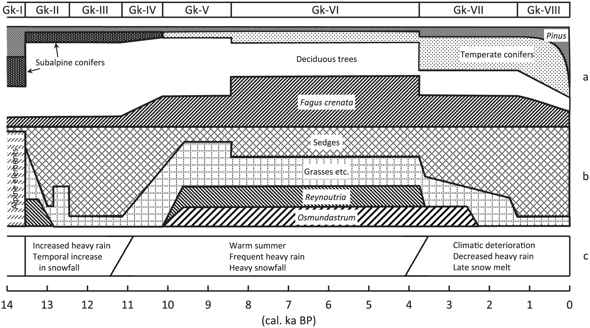
Schematic diagram comparing histories of (a) regional forest and (b) local mire vegetation reconstructed from pollen analysis (this study) and (c) climatic changes estimated by peat analysis (Sohma, 1991).
The increase in abundance of pollen of deciduous broad-leaved trees such as Betula and Q. subgen. Lepidobalanus and the decline in abundance of pollen of pinaceous conifers in the Gk-II zone (13,550–12,440 cal. yr BP) reflect climatic amelioration. The regional forest of subalpine conifers and the local P. pumila scrub in the previous zone were rapidly replaced by deciduous broad-leaved forest dominated by B. ermanii and Quercus crispula. Reynoutria sachalinensis and sedges such as Carex blepharicarpa probably invaded to the bottom of the small basin and formed local communities, and peat deposition started. In the latter half of this zone, R. sachalinensis and the sedges retreated, and subsequently, Poaceae species (probably Moliniopsis japonica and/or Calamagrostis spp.) advanced.
The decline in Q. subgen. Lepidobalanus pollen and the slight increase of Betula, Abies and Pinus pollen in the Gk-III zone imply climatic deterioration during the period between 12,440 and 11,130 cal. yr BP. A high-resolution pollen record and reconstructed temperature curves between 15,701 and 10,217 varve years BP from Lake Suigetsu in Mikata Lowland, about 200 km to the southwest of the site, are available (Nakagawa et al., 2005; Yasuda et al., 2004). The changes in temperature are consistent with this study, and zones SGPI-1b, -1a, SGPS-1 and SGPH of Lake Suigetsu correspond to pollen zones Gk-I, -II, -III and -IV, respectively. Although dates of the zone boundary are 60–200 years younger in this study, these discrepancies may partly arise from differences in sampling resolution (Lake Suigetsu: <15 years, this study: 80–160 years). Hence, the Gk-III cold reversal phase corresponds to SGPS-1 (Younger Dryas) of Lake Suigetsu (Nakagawa et al., 2005). The dominant Cyperaceae pollen in this zone indicates a wet sedge mire condition.
The increase of Q. subgen. Lepidobalanus pollen and the decrease of Betula and pinaceous pollen in the Gk-IV zone (11,130–10,120 cal. yr BP) suggest climatic recovery. Abies, Picea and Tsuga virtually disappeared from around the site. These observations imply an upslope shift of montane broad-leaved trees, even though forest communities would not move en bloc (Roberts, 1989). The population of F. crenata also began to increase, but marked changes are seen only from the Gk-V zone onwards. Although the increase in F. crenata population in this zone shows the beginning of heavy snowfall, it was delayed for 2400 years longer than the increase in Betula and Q. subgen. Lepidobalanus, which were considered to have increased in 13,550 cal. yr BP on account of ameliorated temperature. The tendency of Cyperaceae pollen to decrease suggests a drying of the mire.
The continuous rise in F. crenata pollen and the abrupt decline in Q. subgen. Lepidobalanus pollen in the Gk-V zone (10,120–8410 cal. yr BP) were probably promoted by a stable heavy snowfall regime. The considerable occurrence of Osmundaceae spores and Reynoutria pollen and the fall in Cyperaceae pollen suggest a drier local mire community including O. cinnamomeum and R. sachalinensis.
The dominance of F. crenata pollen and the continuous occurrence of Q. subgen. Cyclobalanopsis pollen in the Gk-VI zone (8410–3740 cal. yr BP) indicate that F. crenata-dominated forest around the site developed to the greatest extent, and forests of evergreen oaks at lower altitudes were established under the climatic optimum of the Holocene. A slight increase in percentages of pollen of temperate conifers such as Cryptomeria, Sciadopitys and Cupressaceae-type was observed after the K-Ah fall (7303–7165 cal. yr BP). The local vegetation and hydrology of the mire was similar to that of the previous zone.
The abundance of several coniferous pollen types such as Pinus, Tsuga, Cryptomeria, Sciadopitys and Cupressaceae-type increased in response to the reduction of F. crenata pollen in the Gk-VII zone (3740–1300 cal. yr BP). Although details of the process of this change are unclear, this phenomenon can be attributed to more favourable conditions for coniferous communities on ridges, which frequently include P. parviflora, T. diversifolia, Cryptomeria japonica, Sciadopitys verticillata, Thuja standishii and/or Thujopsis dolabrata. Since subalpine P. parviflora and T. diversifolia grow around the present site, a slight decline in temperature would also have been responsible for the increase of Pinus and Tsuga pollen. The local conditions of the mire probably became wetter again, as indicated by the increase of the abundance of Cyperaceae pollen and the decrease of that of Reynoutria.
The rapid rise in Pinus pollen towards the surface in the Gk-VIII zone, which is commonly recorded in pollen diagrams from Japan, is attributed to an expansion of secondary Pinus densiflora forest after the disturbance of primeval forests by the intensification of agricultural activities (Tsukada, 1986). The ages of the sudden rise in Pinus pollen are generally delayed northwards, depending on the differences in the time that agriculture was introduced. Since the sediments around the Gk-VII/VIII boundary could not be retrieved, the age of the beginning of Pinus pollen increase, which was interpolated to be about 1300 cal. yr BP, is unclear. In any case, the dominance of Pinus pollen after a horizon (70–75 cm) dated 547–500 cal. yr BP does not conflict with the fact that Pinus pollen dominated in and after the Japanese Middle Ages (758–377 cal. yr BP) at some archaeological sites in the nearest coastal plain (Tanaka and Chiba, 2007). Therefore, the rise in Pinus pollen in zone Gk-VIII presumably resulted from the expansion of P. densiflora forest at lower altitudes. Subalpine P. parviflora would also have been responsible to a certain extent, because this species grows around the present site. The high percentages of Cupressaceae-type pollen in this zone are difficult to interpret, but intensive fluctuations and extreme peaks strongly suggest local pollen deposition near the source (Yonebayashi, 1996). The dominance of Cyperaceae pollen and the virtual absence of Osmundaceae spores of this zone indicate the wettest mire condition.
History of precipitation regime
Although temperature has played a crucial role in the historical changes of vegetation, snowfall regime influenced by sea level changes has also been important for the formation of plant communities in snow-rich regions. Since F. crenata tolerates snow pressure (Homma, 1997), adapts regeneration process to deep snow cover (Homma et al., 1999) and dominates present montane forests in heavy snowfall areas on the Sea of Japan side of Japan (Bradshaw et al., 2010; Hara, 2010; Homma, 2001), the establishment of the F. crenata-dominated forest indicates the onset of a heavy snowfall regime. F. crenata population began to increase in 11,130 cal. yr BP and dominated from 8410 cal. yr BP onwards, although this species had already existed from at least the latest Pleistocene. These observations indicate that the current heavy snowfall regime has been maintained since 11,130 cal. yr BP. In the same core, Sohma (1991) described a changeover at a depth of 500 cm (11,250 cal. yr BP) from peat of high inorganic content with small quantities of herbaceous remains to peat with low inorganic content with abundant woody remains. This change is interpreted to be a result of the climate changing to a continuous heavy snowfall regime. However, temperature amelioration indicated by the changes from subalpine conifers to montane deciduous broad-leaved trees occurred in 13,550 cal. yr BP. Thus, the establishment of the heavy snowfall regime was delayed by more than 2400 years from the preceding temperature restoration in the region around the site. At lower altitudes in western Japan, F. crenata population began to increase around 16,000 cal. yr BP in the Mikata Lowland (Nakagawa et al., 2005; Takahara and Takeoka, 1992; Yasuda et al., 2004) and just above the horizon dated 14,570–13,770 cal. yr BP at Oofuke Moor in the Tango Peninsula (Takahara et al., 1999). These changes reflect expansion of deciduous broad-leaved forest after the Last Glacial Maximum. Fagus pollen became dominant (>40%) before the U-Oki tephra fall (10,177–10,255 cal. yr BP: Smith et al., 2013) at western sites (Jakagamiike Moor: Miyamoto et al., 1999; Oofuke Moor: Takahara et al., 1999), whereas the expansion of F. crenata population was preceded by Betula forest around Gakino-tanbo and Kitadobu bog (Sekiguchi, 2001) in the montane zone of central Japan. Hence, the F. crenata-dominated forest would have established earlier at lower altitudes of western Japan and have expanded to eastern mountainous region, including the region around the study site.
Paleoceanographic studies in the Sea of Japan indicate that continuous inflow of the Tsushima Current, which causes heavy snowfall, has been established since 8 14C ka BP (Oba et al., 1991), and that a dominance of warm water (Tsushima Current) inflow became established in 9.3–6.5 14C ka BP (Gorbarenko and Southon, 2000). The dominance in F. crenata population after 8410 cal. yr BP indicated by this study does not conflict with these dates considering the difference between the 14C age and calibrated age.
The beginning of sedge mire and peat formation in 13,550 cal. yr BP indicates adequate precipitation in the latest Pleistocene. Peat of high inorganic content and the small deposition rate of herbaceous remains between 13,550 and 11,250 cal. yr BP suggest frequent mudflow induced by an increase in summer rain and a high decomposition rate caused by climatic amelioration (Sohma, 1991). The retreat of sedges after 11,130 cal. yr BP and the subsequent invasion of O. cinnamomeum and R. sachalinensis in 10,120 cal. yr BP imply drier mire conditions. Low inorganic material and deposition of abundant woody particles at the middle of the mire between 500 and 250 cm (11,250 and 3820 cal. yr BP) were interpreted as the result of increases in snowfall, summer temperature and heavy rain (Sohma, 1991). However, pollen assemblages indicating frequent heavy rain were not obtained from this study. The increase in snowfall suppressed peat decomposition, and warm summer promoted plant production. The drying of the mire under heavy snowfall conditions can be explained by increased evapotranspiration, increased drought frequency because of higher summer temperatures or a combination of these factors. Other possible factors, such as infilling of the basin and lowering of the groundwater table caused by drainage, are unlikely to have occurred because the input of inorganic matter decreased after the preceding zone, and this small basin had no drainage outlets (Sohma, 1991). The recovery of sedges in 3740 cal. yr BP and their subsequent dominance after 1300 cal. yr BP indicates the wettest mire conditions. The presence of herbaceous or Sphagnum peat without inorganic matter from 3820 cal. yr BP onwards has been explained by delayed snow melt in response to a decrease in temperature and decreased frequency of heavy rain (Sohma, 1991). The increase in some subalpine conifers after 3740 cal. yr BP is consistent with these conditions.
Conclusion
The population of F. crenata started to increase in 11,130 cal. yr BP and has dominated since 8410 cal. yr BP, which indicates that a heavy snowfall regime induced by the inflow of the Tsushima Current was established in 11,130 cal. yr BP and has been maintained thereafter. The onset of sedge mire and peat formation in 13,550 implies climatic amelioration and an increase in summer rain. The retreat of sedges after 11,130 cal. yr BP and subsequent invasion of O. cinnamomeum and R. sachalinensis indicate drier mire conditions induced by the increases in summer temperature and heavy snowfall. The recovery of sedges in 3740 cal. yr BP and their subsequent dominance after 1300 cal. yr BP indicate the wettest mire condition, which was caused by climatic deterioration.
Footnotes
Acknowledgements
I wish to express my sincere gratitude to late Professor Hidehiro Sohma, Nara Women’s University, who provided the opportunity for me to undertake this study and gave me access to core samples from a previous study. I thank M Oishi and K Homma for providing information on relevant literature. Permission to sample within the protection zone was kindly granted to Prof. H Sohma by the Ministry of the Environment, Japan. I thank two anonymous reviewers for their critical comments on the manuscript.
Declaration of conflicting interests
The author(s) declared no potential conflicts of interest with respect to the research, authorship and/or publication of this article.
Funding
The author(s) received no financial support for the research, authorship and/or publication of this article.