
Abstract
The question of what the ecology communities of the Loess Plateau looked like before the extensive anthropogenic reshaping processes of the late-Holocene has stirred a long debate. A better understanding of these human-induced changes will not only help us understand the extent of paleoeconomic practices, but also inform future conservation actions on this ecologically fragile landscape. This paper presents a systematic study of wood charcoal from a series of archaeological sites, demonstrating that woody plants and woodlands were widely distributed and geographically diverse on the Loess Plateau in response to the East Asian Monsoon. In the Guanzhong Basin, oak (Quercus spp.) woodlands were associated with a few tropical-subtropical taxa, which changed to oak and pine (Pinus spp.) mixed forests on the eastern plateau, while on the northern plateau coniferous woodlands were dominant. On the western Loess Plateau, oak and elm (Ulmus spp.) woodland and spruce (Picea spp.) forests were widespread. The charcoal results suggest that human impacts on the dominant species might have begun as early as ca. 3500 cal yr BP, with oak replaced by Prunus as the dominant taxon, including many economically significant species, such as peaches (P. persica) and apricots (P. armeniaca). Furthermore, the charcoal data show that due to warm and wet climatic conditions in the mid-Holocene, the distribution of tropical-subtropical taxa shifted markedly northwards into the Guanzhong and Tianshui Basins, and the central part of the eastern Loess Plateau, which became characterized by high frequencies of Bamboo.
Introduction
Located in northern China, the climate of the Loess Plateau is principally influenced by the East Asian Monsoon (EAM) and characterized by a fragile ecosystem (Liu, 1985). Current evidence shows that this region is part of the broad center of origin for both broomcorn (Panicum miliaceum) and foxtail millet (Setaria italica), with cultivation beginning as early as 8000 cal yr BP (Hu et al., 2009; Liu et al., 2004). The rapid expansion of a farming economy led to significant changes in vegetation communities across this area (Lu et al., 2003; Shu et al., 2006). Pollen and charcoal archives reveal that the frequency of human-induced fires increased significantly during this period, and agricultural activities reduced trees and promoted grasslands (Li et al., 2009; Tan et al., 2015; Zhou et al., 2011). Additionally, since the loess is loose, porous, homogeneous and easily soluble in water, the landscape here has experienced considerable soil erosion (Liu, 1985; Zhao et al., 2013). The National Development and Reform Commission et al. (2010) reported this region as one of the most erosion-prone areas in China, with a particularly susceptible area of 4.72 × 10⁵ km2. Reconstructing the vegetation history of the Loess Plateau in an attempt to understand its natural woodland communities and vegetation responses to climate change, has become key to the future ecological conservation of this significant region (Liu et al., 1994; Lu et al., 1999, 2003, 2007). Also, the data and conclusions that we present here place East Asia into global-scale discussions of anthropogenic impacts on the environment. Understanding anthropogenic changes on the Loess Plateau is important to any discussion of human impacts on the globe, as this region saw some of the most rapid demographic expansions in human history and prehistory and continues to support high densities of human occupation (Hosner et al., 2016).
Over the past few decades, attempts to understand the natural vegetation of this plateau, using different climatic proxies have resulted in controversial conclusions. Based on historical records, Shi (1991) claimed that forests and forest-steppes occurred extensively, covering up to 53% of the plateau during the mid-Holocene. However, studies of paleoclimatic indicators such as pollen and phytoliths suggest a different vegetation history (Liu et al., 1994; Lu et al., 1999; Sun et al., 1995, 1998; Zhang and An, 1994). For example, Sun et al. (1995) demonstrated with palynological data that vegetation types throughout the Holocene were dominated by grasslands and some associated broadleaf trees. Relying primarily on phytolith archives, Lu et al. (1999) concluded that since the last interglacial period, grasslands and forest-steppes were widespread on the southern Loess Plateau, and that short-lived forest patches might have occurred only when the annual precipitation exceeded 800 mm during the Holocene Climate Optimum. At present, a growing corpus of studies have argued that prehistoric vegetation on the plateau is likely to have been highly spatially variable, and that it was always dominated by grasslands in the ‘Yuan’ areas (the tablelands), with no large areas of stable forest vegetation (Guo et al., 1994; Li et al., 2003; Lu et al., 2003; Xia et al., 1998; Xie et al., 2002). By contrast, in the valleys and mountains of the plateau, forests were likely well-developed (Lu et al., 2003).
However, due to limitations inherent in palynological methods, many questions remain unanswered regarding the composition and distribution of woodland patches, especially in valleys and protected areas away from heavy megafaunal herbivory. Some of these methodological issues include poor preservation of pollen in loess soils, relatively low resolution of pollen identification, and the fact that several of the main woody plant clades are insect-pollinated (e.g., Rosaceae) (Asouti et al., 2015; Kabukcu, 2017; Shen et al., 2018). Likewise, statistical studies are increasingly illustrating how unreliable temporal extrapolations can be when interpreting sediment cores, especially from lakes with high turbulence and uneven sedimentation (Carleton et al., 2014). Additionally, scarcity of good sediment achieves for pollen on the Loess Plateau, such as small lake/bog sites, has hampered the application of vegetation models.
Wood charcoal remains found in archaeological sites directly represent the use of wood as fuel and, therefore, comprise a combination of human selection choices and the composition of locally available wood (Kabukcu, 2018; Théry-Parisot et al., 2010). The carbonization process reduces microbial decomposition, and often leaves the anatomical features of the wood well-preserved, making it possible to precisely identify specimens that can be directly dated (Moskal-del Hoyo et al., 2010; Scott, 2010). Although many factors, such as wood features and cultural preference, can affect firewood collection, it is widely recognized that the availability of woody plants is one of the most important factors determining their ease of collection and thus their percentage abudannce in an assemblage can be regarded as a reflection of their proportions in local woodland (Asouti and Austin, 2005). In comparison to pollen, wood charcoal analyses allow for a relatively high taxonomic resolution, often to genus or sometimes species level (Cui et al., 2002). As a result, wood charcoal analyses are an effective tool for reconstructing the history of woodlands in semi-arid and arid regions, especially when incorporated into multiproxy interpretations also involving pollen and other lines of paleoclimatic data (Asouti and Hather, 2001; Asouti and Kabukcu, 2014).
Currently, wood charcoal research in East Asia is mainly restricted to northwest China (An et al., 2014; Li et al., 2013, 2016; Sun et al., 2013, 2016; Wang et al., 2011b). However, studies remain quite sporadic and are absent for most parts of the Loess Plateau. In this paper we present the results of anthracological analyses conducted on stratified charcoal assemblages from 13 archaeological sites on the plateau to explore its woodland histories.
Study area
The Loess Plateau (33°43′ to 40°16′ N, 100°45′ to 114°33′ E), with a total area of about 4.4 ×10⁵ km2, is traversed by the Yellow River (Liu, 1985) (Figure 1). The terrain is high in the northwest and low in the southeast, with a range of 1000–2000 m above sea level (masl; Wang et al., 2014). It is characterized by a typically continental monsoonal climate, being cold and dry when under the control of the Siberian High during the winter, and hot and humid in the summer months, when the EAM transports water vapor from the tropical Pacific Ocean. The mean annual temperature (MAT) range is 0–13°C, and the mean annual precipitation (MAP) range falls between 150 and 750 mm (Li et al., 2008; Yu et al., 2002; Figure 2).
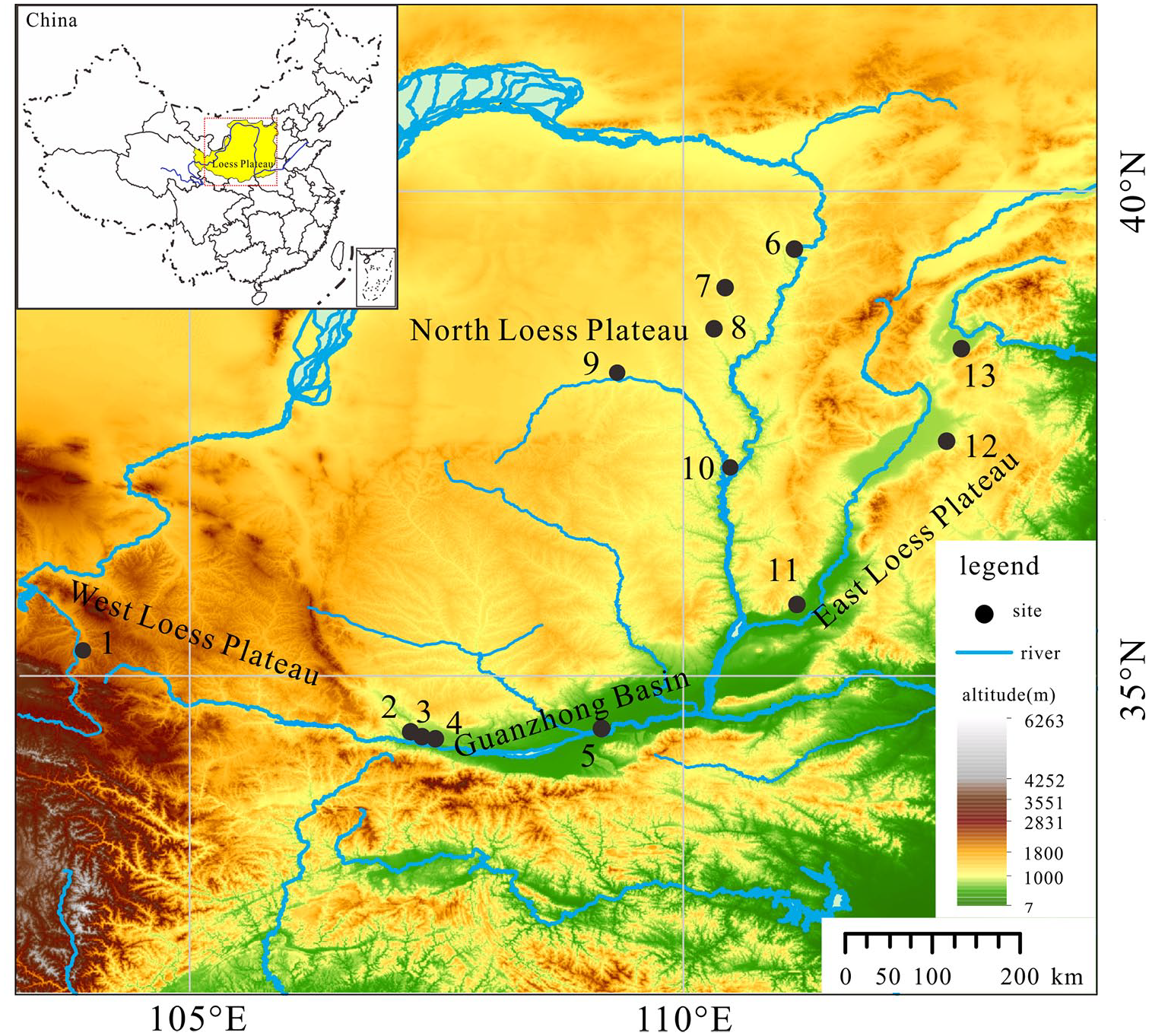
Location of the Loess Plateau and 13 archaeological sites in this study. (1) Majiayao. (2) Shangguancun. (3) Liujiatai. (4) Panhe. (5) Ma’nan. (6) Dakou. (7) Zhaimao. (8) Shimao. (9) Xiaojiamao. (10) Lijiaya. (11) Guangcun. (12). Baiyan. (13). Youyao. (single-column).

Vegetation types, mean annual temperature (MAT) and mean annual precipitation (MAP) for the Loess Plateau. (I) Forest. (II) Woodland. (III) Steppe. (IV) Desert steppe. (V) Desert (modified from Integrated investigation team of the Loess Plateau, CAS, 1991; Wang et al., 2011a). (single-column).
With the spatial variation in climatic conditions, the general trend in vegetation types progresses from forest, to forest-steppe, to steppe, to desert-steppe and to desert, from southeast to northwest (Shu et al., 2006; Figure 2). Forests are only found on the southeastern part where the vegetation community is dominated by Quercus variabilis, Q. aliena, and Q. acutissima. The forest-steppe is dominated by xerophytic, herbaceous plants and characterized by environmentally dwarfed trees. Representative trees include Prunus sibirica, Ulmus macrocarpa and U. glaucescens (Zhu, 1994). Steppe vegetation is usually represented by Artemisia leucophylla, Caragana korshinskii, C. microphylla, Stipa bungeana and Ziziphus jujuba. The desert steppe mainly consists of Artemisia ordosica, Haloxylon ammodendron, Stipa caucasica and S. breviflora. Desert vegetation is restricted to the northwestern part; typical arid-land plants include Ammopiptanthus mongolicus, Kalidium foliatum and Sympegma regelii.
Material and methods
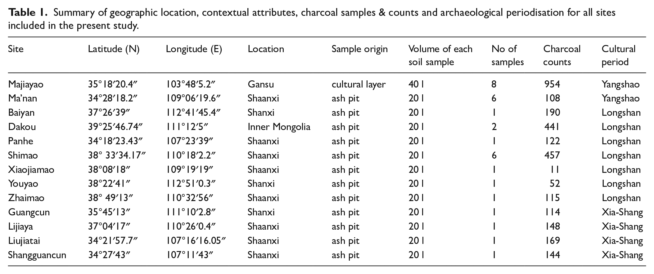
We analyzed material from 13 archaeological sites including Shangguancun, Liujiatai, Panhe and Ma’nan on the Guanzhong Basin; Guangcun, Baiyan and Youyao on the eastern side of the plateau; Dakou, Zhaimao, Shimao, Xiaojiamao and Lijiaya on the northern plateau; and the Majiayao sites on the western plateau (Figure 1 and Table 1). These sites cover a timespan from the Yangshao Tradition (7000–5000 cal yr BP), to the Longshan Tradition (5000–4000 cal yr BP), to the Xia-Shang Period (4000–3000 cal yr BP) (Table 1). Of them, only one site (Majiayao) exhibits a continuous cultural sequence, with a stratigraphy 3.8 m in depth. Eight samples were collected from a stratigraphic column at Majiayao at 20 cm intervals, with a volume of soil for each sample of about 40 L. For the other sites, all the samples were acquired from ash pits, and each had a volume of roughly 20 L per sample.
Summary of geographic location, contextual attributes, charcoal samples & counts and archaeological periodisation for all sites included in the present study.
Archaeobotanical samples in this study were retrieved through manual tank flotation, with the mesh size of 0.3 mm. All wood charcoal specimens were collected from the float fraction only. Wood charcoal was botanically identified following standard protocols and microscopy work was focused on wood charcoal specimens >4 mm in order to minimize identification biases as suggested in previous studies (Asouti and Austin, 2005; Chabal et al., 1999; Kabukcu, 2018; Théry-Parisot et al., 2010). For wood charcoal samples containing more than 100 fragments >4 mm, we stopped counting once the number of taxa identified stabilized. If there were not sufficient charcoal fragments >4 mm, we tried to identify (depending on the preservation of sufficient anatomical features) charcoal from <4 mm. Each wood charcoal fragment was either hand- or pressure-fractured with a razor blade to acquire three fresh sections (including transverse, tangential and radial sections), and then examined under a reflected light microscopy at magnifications of ×50, ×l00, ×200, ×400 and ×500. Based on the anatomical characters evident from the three sections, and using atlases of modern wood anatomy (Cheng et al., 1992; Yao et al., 2002; Zhou et al., 1994) as a point of reference, charcoal fragments were identified into different wood genera or families. The main types of wood charcoal found on the Loess Plateau were also photographed using a scanning electron microscope (see Supplementary material 1).
Our modelling of past woodlands, using wood charcoal assemblages, was based on ecological studies of present-day vegetation distribution, woodland composition and individual species habit (Integrated investigation team of the Loess Plateau, CAS, 1991; Wu, 1991; Wu et al., 2013). Drawing on data compiled by the Flora of China (Wu et al., 2013), Plants of the World Online by Royal Botanical Garden, Kew (http://www.plantsoftheworldonline.org/), and Wu (1991), we classified each taxon into different bioclimatic regions before exploring the implications of this classification for reconstructing different woodland vegetation types.
Results
A chronology for each site was established using AMS 14C dating. In addition to ages of four sites, including Majiayao, Dakou, Shimao and Lijiaya, that had been previously dated, nine new AMS dates were generated for the present study. The results show that all 13 sites in this study fall within a period ranging between 5300 and 3000 cal yr BP (Table 2). The Majiayao and Ma’nan sites are relatively early, dating back to 5300–5000 cal yr BP, falling in the Yangshao cultural period. Five Longshang-Culture-affiliated sites, (Xiaojiamao, Baiyan, Panhe, Youyao and Dakou) were selected. Six sites date to the Xia-Shang Period. Of these, Zhaimao, Liujiatai and Guangcun fall within the 3900–3800 cal yr BP period, followed by Shimao (3800–3700 cal yr BP), Shangguancun (3500–3400 cal yr BP), and Lijiayao (3100–3000 cal yr BP).
AMS14C dates for the 13 archaeological sites discussed in this study.

In total, we identified and quantified 2911 fragments of wood charcoal from the 13 sites, that is, a mean of 224 fragments from each site. 23 taxa, including four coniferous trees and 19 broadleaved plants, were identified. The detailed information of wood charcoal identification from each site can be found in Supplementary material 2. All percentage fragment counts are based on the total number of identified charcoal fragments found at each site.
The Guanzhong Basin sites
Charcoal results from Ma’nan in the Yangshao Period show that four wood types were predominantly used including Ziziphus, Ulmus, Quercus and Tamarix. Ziziphus (>70%) was the most common type, followed by Ulmus at roughly 18% (Figure 3). Nine wood types from samples dated to the Longshan Period were identified, with Quercus being the most abundant taxon (>70%), followed by Ulmus (11%). Acer, Ailanthus, Bambusoideae, Celtis, Maloideae, other taxa were present with proportions of less than 6%.

A total of 169 fragments of charcoal from the Xia-Shang Period were identified at the Liujiatai site, dominated by Quercus (75%). Ulmus fragments comprised 16% of the assemblage from this period. Other taxa such as Acer, Maloideae, Populus/Salix, Prunus and Rhus registered very low proportions of <5% each. Eight broadleaved taxa occur at the later site of Shangguancun where Prunus was dominant (about 60%), with Quercus dropping to about 10%. Ulmus fragments were also found in relatively large numbers, comprising about 13% of the total. Acer, Ailanthus, Bambusoideae, Maloideae and Populus/Salix represented <10% each.
The eastern Loess Plateau sites
Charcoal records from the Baiyan site for the Longshan Period suggest that 11 woody taxa appeared at that time (Figure 4). Platycladus wood fragments comprise the highest proportion of conifers at about 30%, followed by Pinus at 10%. Only a very small number of Abies specimens was recovered. Quercus is the most abundant broadleaved taxon, accounting for 25% of the assemblage. Prunus and Ulmus specimens account for nearly 9% each. Other trees include Ailanthus, Bambusoideae, Maloideae, Salix/Populus and Rhamnus (<10% each). Data from Youyao (later Longshan Period) suggest that Quercus and Acer were the most commonly used fuel woods, constituting nearly 40% and 25% of the charcoal assemblage, respectively, followed by Pinus. Abies, Populus/Salix, Prunus, Rhamnus and Ulmus wood fragments were all found in smaller proportions (<6% each).

Wood charcoal results from the eastern Loess Plateau. (2-column).
Eight wood taxa were identified from the Xia-Shang Period at Guangcun. Abies and Pinus, with percentages of about 10% and 5% respectively, are the only coniferous trees. Quercus is still the most common tree during this period, comprising about 35%, followed by Ulmus (18%) and Ziziphus (13%). Acer, Bambusoideae and Prunus wood fragments account for <5% each.
The northern Loess Plateau sites
During the Longshan Period Pinus, Quercus, Prunus, Rhus and Ulmus fragments were present at Xiaojiamao (Figure 5). At Dakou, nine taxa were identified, including one coniferous tree and eight broadleaved taxa. Pinus fragments recorded the highest percentage, at about 40%. Broadleaved plants mainly consisted of Alnus and Prunus (35% and 12% respectively). Other taxa, including Betula, Celtis, Maloideae and Quercus, registered proportions of <10% each.

Wood charcoal results from the northern Loess Plateau (“+” means the presence of wood taxon). (2-column).
For the Xia-Shang Period, data from Zhaimao show that Pinus is still the most abundant taxon, reaching nearly 60%. Abies accounts for 18% of the assemblage. Quercus is the main broadleaved taxon, with a percentage of 12%, followed by Celtis, Prunus, and Ulmus. At Shimao, Pinus fragments account for >60% of the assemblage, followed by Ulmus. The other identified genera include Abies, Prunus and Quercus, at roughly 5% each. The proportion of Pinus at the later Lijiaya site fell to 34%, with a smaller proportion of Abies (7%). Broadleaved taxa included Picrasma, Rhus and Ulmus, with percentages of between 10%–25%, followed by Maloideae, Populus/Salix, Quercus and Rhamnus.
The western Loess Plateau sites
In this region, we identified 954 fragments of charcoal from eight samples at Majiayao. The charcoal results attest to the presence of 13 taxa including 2 conifers and 11 broadleaves (Figure 6). For conifers, Picea fluctuates between 3% and 37%, with a mean value of about 20%, much higher than that of Abies. Quercus is the most abundant broadleaved taxon, with a mean proportion of about 25%, reaching nearly 80% in layer 6. Populus/Salix, which has a mean proportion of 17% is followed by Ulmus accounting for 10%. Other taxa, like Acer, Alnus, Betula, and Castanea are found only in small numbers. In the early phase (layers 6-8), Quercus fragments increase dramatically, from 6% to 78%. Conversely, Picea rapidly drops from 37% to < 4%.
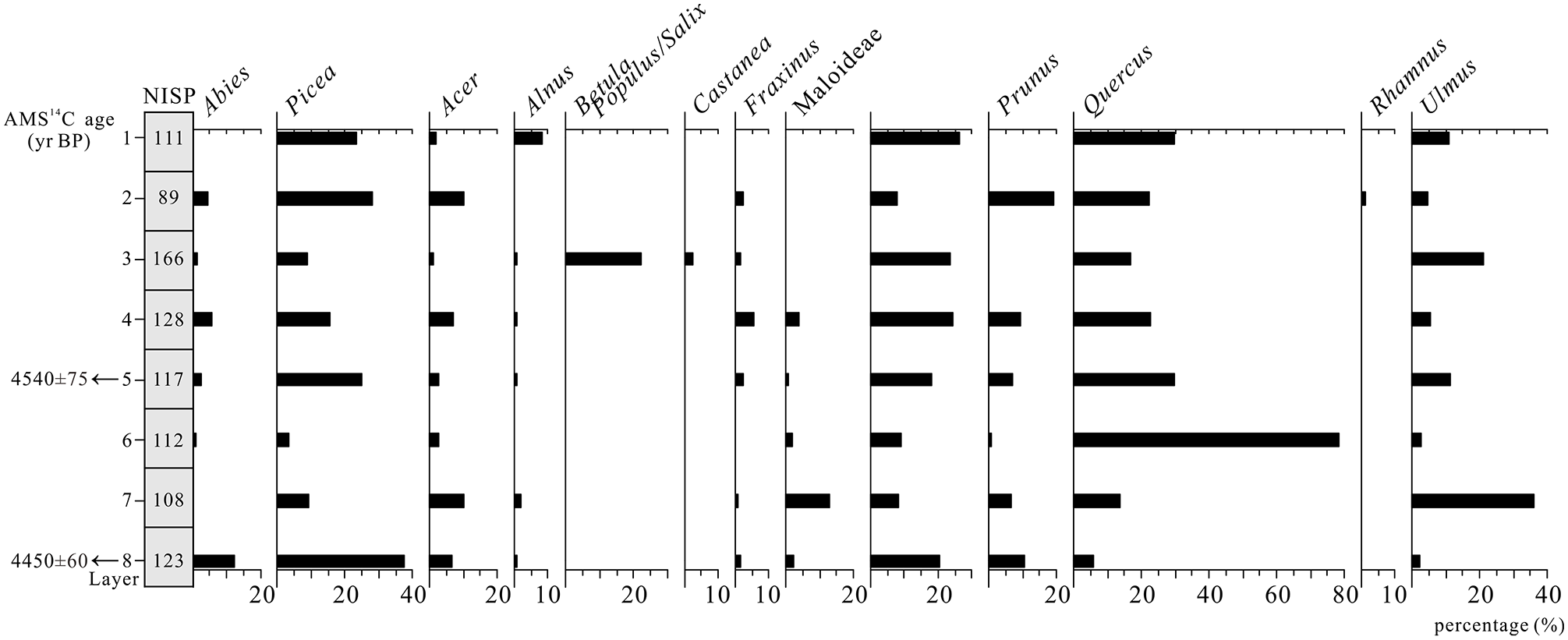
Wood charcoal results from Majiayao on the western Loess Plateau. (1.5-column).
Discussion
The geographic distributions of the 23 plants identified in this study were divided into different groups, such as north temperate and cosmopolitan (Table 3). Abies, Picea, and Pinus are usually restricted to temperate regions. Platycladus is widely distributed and typically found throughout East Asia. Of the broadleaved taxa, Ailanthus and Ziziphus are normally distributed in tropical and/or subtropical areas, as are Bambusoideae. However, considering that Ailanthus and Ziziphus are found almost throughout China, only Bambusoideae are classified as characteristic of tropical-subtropical vegetation communities in this study. Alnus, Betula, Castanea, Fraxinus, Quercus and Ulmus grow mostly in temperate regions. Celtis, Maloideae and Rhamnus, are widely distributed in both tropical and temperate regions.
Geographical distributions of 23 taxa found on the Loess Plateau.

According to a survey of present-day vegetation on the Loess Plateau conducted by the Integrated investigation team of the Loess Plateau CAS, (1991), Picea and Abies mostly prefer humid and cold conditions and their distributions are usually restricted to high-latitudes and subalpine areas. Conversely, Pinus and Platycladus are usually found in relatively warm and dry environments; indeed, they dominate coniferous forests distributed along the hills of the plateau. Today, Pinus tabuliformis is the most abundant pine species and is often associated with oak forests on the southeastern Loess Plateau, while it occurs as pure pine forests in arid mountainous regions. Quercus is the dominant tree found in temperate, deciduous, broadleaved forests. On the Loess Plateau, oak woodlands are restricted to the southern and eastern parts and can be replaced by pioneer Populus or Betula forests when destroyed by human activities, such as cutting. Birch forests comprise the second largest woodland type and are found in most of the Loess Plateau’s mountainous areas today.
Reconstruction of woodland composition
Drawing on our results and previously published anthracological studies from the Loess Plateau (An et al., 2014; Sun et al., 2013, 2014, 2016; Li et al., 2016; Wang et al., 2011b) (Table 4), we infer that woodlands were widespread and characterized by significant spatial differences in distribution (Figure 7). In the Guanzhong Basin, combining our findings with previous charcoal studies from Huiduipo, Beiniu and Xiahe (Sun et al., 2014, 2016), we find that a wide range of taxa occurred in this area (Table 4). During the Yangshao Period, Quercus was the dominant taxon and some tropical-subtropical taxa, such as Fargesia and Sassafras, also occurred. Charcoal records from the Longshan Period suggest that Quercus was still the most common taxon, associated with the presence of Bambusoideae. With regard to the early Xia-Shang period, oak woodlands dominated the landscape and the diversity of broadleaved taxa does not show clear changes compared to the Longshan period. Therefore, we infer that broadleaved forests, dominated by oak and associated with some tropical-subtropical taxa like Fargesia, were the main woodland type from the Yangshao to the early Xia-Shang periods. Phytolith evidence from the Weinan section also reveals the presence of Bambusoideae during this period (Lu et al., 1994), while pollen analysis from a loess section suggests that an Artemisia grassland dominated in the mid-Holocene, implying that vegetation in the ‘Yuan’ area was very different from that in the valley (Sun et al., 1995).
Anthracological data from previous studies on the Loess Plateau (N: number of samples; C: charcoal fragment counts; % C: percentage of charcoal fragment counts).

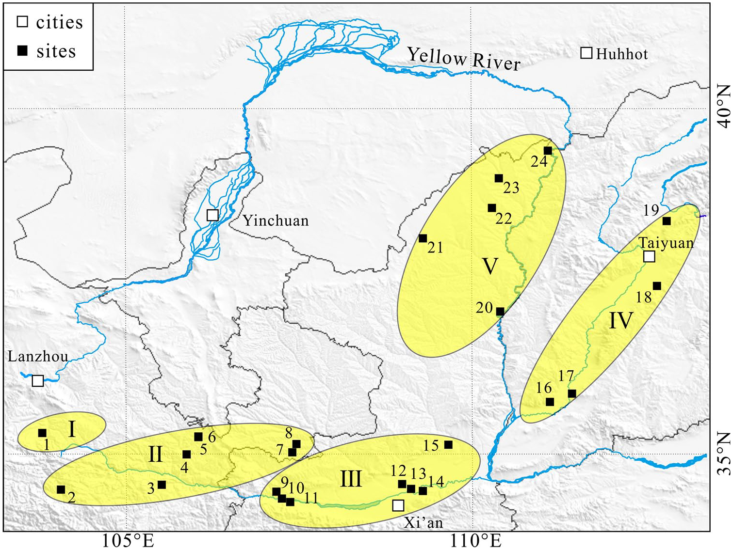
Reconstruction of the woodland types found on the Loess Plateau. (I) Western plateau, Quercus and Ulmus woodland, and Picea forest. (II) Tianshui Basin, Quercus woodland associated with a few tropical-subtropical taxa, and Picea forest. (III) Guanzhong Basin, Quercus woodland associated with a few tropical-subtropical taxa. (IV) Eastern plateau, Quercus and Pinus mixed woodland. (V) Northern plateau, Pinus woodland. 1, Majiayao; 2, Shannashuzha; 3, Xishanping; 4, Dadiwan; 5, Gaozhuang; 6, Daping; 7, Jiangjiazui; 8, Qiaocun; 9, Shangguancun; 10, Liujiatai; 11, Panhe; 12, Huiduipo; 13, Ma’nan; 14, Beiniu; 15, Xiahe; 16, Guangcun; 17, Taosi; 18, Baiyan; 19, Youyao; 20, Lijiaya; 21, Xiaojiamao; 22, Shimao; 23, Zhaimao; 24, Dakou. (single-column).
Around 3500 years ago, changes in wood charcoal assemblage composition are evidenced. Notably, Quercus declines sharply to only 10%, while Prunus greatly increases to nearly 60% at Shangguancun. In natural vegetation, Prunus only occurs in small numbers and is much less abundant than Quercus. The high presence of Prunus at Shangguancun, thus, is likely to have resulted from anthropogenic selection. Additionally, nuts, notably acorns, were widely exploited in East Asia (e.g. by the Jomon and Liangzhu groups) before the transition to farming, supported by the occurrence of abundant nut remains and storage pits (Hosoya, 2011; Qin et al., 2010). Wild relatives of peaches, including Prunus persica, P. davidinia, P. armeniaca and P. mira are widespread across northern China (Lu and Bartholomew, 2003). All of these species would have been likely targets for early foragers and archaeobotanical evidence suggests that P. armeniaca and P. persica were probably cultivated or heavily collected by people in the lower Yangtze River valley by 4000 cal BP (Fuller and Stevens, 2019; Zheng et al., 2014). We hypothesize that these changes in charcoal assemblage composition were likely to be anthropogenic, as humans chose to harvest certain arboreal taxa as fuel and favored the preservation of economically significant fruit trees. This may also reflect shifts in subsistence practices, as archaeobotanical data indicate that pre-Neolithic cultures in China relied heavily on acorns as a food source; the use of acorns seems to have declined as farming became more prominent – coinciding with in the decline of oak forests. Similarly, increases in Rosaceae charcoal percentages during this period may indicate greater investment in and possible cultivation of fruit-producing trees.
On the eastern plateau, charcoal results from early Longshan Period sites suggest coniferous woods mainly consisted of Platycladus and Pinus. Quercus is the dominant broadleaved tree, and tropical-subtropical species are also present. During the late Longshan stage, Quercus is still the most common broadleaved taxon, and the coniferous charcoal taxa are principally Pinus, which is also supported by wood charcoal studies at Taosi (Wang et al., 2011b) (Table 4). Subsequently, Quercus and Ulmus account for more than half of the total species in the early Xia-Shang Period and coniferous trees, including Pinus and topical-subtropical taxa, are also present. Collectively, we infer that Quercus and Pinus mixed forests remained stable for a long period on the eastern plateau. A pollen record from Gonghai Lake also suggests that Pinus and Quercus were the dominant tree taxa during 5000–3000 cal yr BP (Xu et al., 2016).
On the northern plateau, our results show that Pinus was the main species identified, followed by Alnus and Prunus during the Longshan Period. Charcoal data for the Xia-Shang Period suggest that Pinus still remained the most abundant tree, accounting for >30% of the assemblage, and up to 60% at Shimao. We suggest that pine forests were a dominant land cover type, alongside sparse broadleaved forests, which is consistent with the pollen analysis from the Daihai Lake (Xiao et al., 2004).
On the western plateau, wood charcoal reveals that spruce and oak were dominant in the regional vegetation. Spruce forests probably occurred in the hinterlands of mountain ranges, which differed from woodlands (including Quercus, Picea and some tropical-subtropical trees) distributed on the Tianshui Basin (An et al., 2014; Sun et al., 2013) (Figure 7 and Table 4). At Majiayao, the woodland communities were dominated by oak, elm and spruce through all the site’s cultural layers. In the early stages, Quercus shows a rapid increase and Picea declines quickly, indicating that the site inhabitants might have consciously selected and utilized spruce wood for fuel, thus leading to a decline of the local spruce forest. The rapid decrease of Picea is also supported by the pollen record from the same section (Zhou, 2009).
Drawing on all these anthracological studies, oak forests were largely distributed across the southern plateau, while they only occurred sporadically in the northern parts, where drought-tolerant pine forests were dominant. The eastern part appears to be a transition zone, as Quercus and Pinus constitute the two most abundant woody taxa. The western plateau, where oak was the dominant taxon, is relatively different as spruce also occurred abundantly which is usually distributed in cold and humid environments. This spatial difference likely implies that climatic conditions gradually changed from warm and wet to dry and cold from the Guanzhong Basin to the eastern and northern areas, while the western plateau was relatively cold and wet. Additionally, the differences in woodland composition appear to correspond well with regional variance in precipitation and temperature regimes, indicating that climatic conditions exerted significant selective pressure upon local woody vegetation communities. As the EAM weakens, moving from the southeast to the northwest, hygrophilous plants gradually decline while drought-tolerant taxa increase.
The northern limits of tropical-subtropical taxa
Previous paleoclimatic reconstructions suggest that climatic conditions during the mid-Holocene were relatively warm and humid, and these exerted a significant impact on vegetation (Shi and Kong, 1992; Shi et al., 1992; Zhao and Yu, 2012). How the vegetation zonation shifted during this period is a subject of debate (Shi et al., 1993; Zhu, 1988). Studies of different archives, such as pollen records, phytoliths, soil microstructure and chemical analysis, wood charcoal and literary records have indicated that, tropical-subtropical species made a clear range shift at this time (Fan and Li, 2005; Li et al., 2015; Sun et al., 2013; Yu et al., 1998; Zhao, 2003). There still remains a debate about how far the climatic zone shifted, as well as the detailed process behind the response of tropical-subtropical trees to this shift. Here, we combined current charcoal research results to discuss these issues, focusing on the movement of tropical-subtropical taxa across the Loess Plateau.
On the Loess Plateau, numerous tropical-subtropical taxa such as Bambusoideae, Fargesia, Hibiscus, Liquidambar formosana, Melia, Phyllostachys, Sassafras and Stewartia, were identified in studies of wood charcoal remains from Beiniu and Huidui (Sun et al., 2016), Xiahe (Sun et al., 2014), Xishanping and Dadiwan (Sun et al., 2013), Taosi (Wang et al., 2011b), Shannashuzha (Li et al., 2016), Daping, Gaozhuang, Qiaocun and Jiangjiazui (An et al., 2014) (Figure 8 and Table 5). Of these taxa, Bambusoideae occur at 12 sites with a frequency of 50% and are the most abundant of the tropical-subtropical taxa. Some species, like Castanopsis, Cyclobalanopsis, Olea, Osyris and Toxicodendron, have been identified by previous studies but are excluded here due to issues related to taxonomy and the level of possible taxonomic certainty based on diagnostic anatomical features, as well as questions regarding the ancient distribution ranges of certain species that are rare in China today. A few issues that require further investigation are: (1) Castanopsis is anatomically indistinguishable from Quercus; (2) most Cyclobalanopsis has been clumped into the Quercus genus and only two species, namely Cyclobalanopsis hefleriana and C. sichourensis, which only occur in Southwest China, are accepted (http://www.theplantlist.org/; Huang et al., 1999); (3) Olea is mostly distributed in southern China and is anatomically similar to Osmanthus (Chang et al., 1996); (4) Osyris is rare in China, only occurring in Tibet, Sichuan, Yunnan, Guangxi and its presence in northern China needs further proof (Xia and Gilbert, 2003); (5) Toxicodendron is generally accepted as a member of the broader Rhus clade in Anacardiaceae (diverse in East Asia) (http://www.theplantlist.org/).
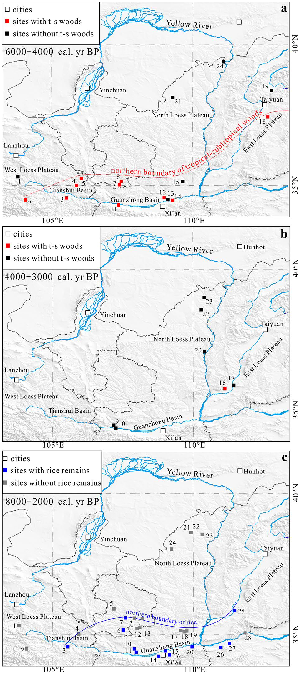
Reconstruction of the distribution of tropical-subtropical woods and farming sites. (a) The northern boundary of t-s woods during the Middle Holocene. (b) The distribution of tropical-subtropical (t-s) woods during the Late-Holocene. (c) The distribution of farming sites during 8000–2000 cal yr BP (see Supplementary material 3). For site number coding in subfigure a and b see Figure 7. Site number in subfigure c: 1, Majiayao; 2, Shannashuzha; 3, Xishanping; 4, Dadiwan; 5, Changshan; 6, Qiaocun; 7, Nanzuo; 8, Yanggu; 9, Yuergu; 10, Zhouyuan; 11, Anban; 12, Wujiapo; 13, Gongjiachuan; 14, Yuhuazhai; 15, Xi’an Han Tomb; 16, Xinjie; 17, Nanshantou; 18, Muwanghe; 19, Xiahe; 20, Xinglefang; 21, Muzhuzhuliang; 22, Shenggedaliang; 23, Shimao; 24, Yangjiesha; 25, Taosi; 26, Didong; 27, Nanjiaokou; 28, Bancun.
Representation of tropical-subtropical charcoal taxa found on the Loess Plateau.
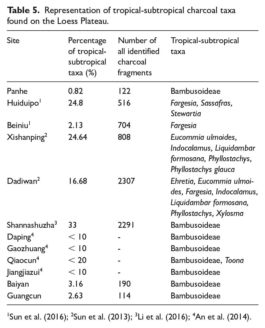
Tropical-subtropical woods are mostly found in the Guanzhong and Tianshui Basins. In the Guanzhong Basin, tropical-subtropical taxa have been found in samples spanning the whole study period. Charcoal data from Huiduipo indicate the presence of three tropical-subtropical taxa including Fargesia, Sassafras and Stewartia, representing 24.8% of the charcoal assemblage (Table 5). During the Late-Holocene, Bambusoideae are only found in small numbers. On the eastern plateau, no tropical-subtropical taxa have been identified north of the site of Baiyan.
In the Tianshui Basin, charcoal results suggest that the diversity of arboreal taxa was quite high. At Dadiwan seven tropical-subtropical plants, such as Fargesia, Indocalamus and Liquidambar formosana were found. At the relatively late Xishanping site, tropical-subtropical taxa were included by Eucommia ulmoides, Indocalamus, Liquidambar formosana and Phyllostachys. A certain number of Bambusoideae taxa are also evident at ca. 4000 cal yr BP. However, at Majiayao in this study, there is no occurrence of subtropical or tropical taxa.
The range of the tropical-subtropical taxa on the Loess Plateau represented by Bambusoideae, Eucommia ulmoides, Fargesia, Liquidambar formosana and Phyllostachys shifted significantly northward during the mid-Holocene. Bambusoideae, with the highest frequencies, were likely the pioneer species during this northward movement. Our results also suggest that the northern margins of the distribution zone of this group fell approximately along the northern peripheries of the Tianshui Basin, the Guanzhong Basin, and the central part of the eastern Loess Plateau (Figure 8a). During the Late-Holocene, with the onset of cooler and more arid conditions, both the diversity and percentages of tropical-subtropical taxa showed a rapid reduction (Figure 8b).
In addition, it is worth noting that the northern periphery of the ancient rice-growing sites is quite close to that of the tropical-subtropical taxa (Figure 8c). Referring to previous studies related to early agricultural dispersal, rice-growing sites have mostly been found in regions located south of 37°N, which are also influenced by the EAM (He et al., 2017). On the plateau, archaeobotanical rice remains are restricted to the Tianshui and Guanzhong Basins and the central part of the eastern plateau, with almost no occurrence of rice having been reported north of this line (Figure 8c) (see Supplementary material 3). This coincidence might imply that early rice planting spread widely across northern China, but that its dispersal was most probably constrained by shifting climatic conditions. The northern margins of the tropical-subtropical forests may also, therefore, represent the northerly limits of the expansion of rice-based agriculture.
Conclusion
Collectively, the evidence presented in this paper feeds into a growing understanding of shifting vegetation communities across the Loess Plateau during the second half of the Holocene. Charcoal evidence demonstrates that woodlands were widespread and geographically diverse on the plateau, in response to the EAM. At about 3500 cal yr BP, human impact had led to the transformation of vegetation composition as the dominance of oak was replaced by Prunus spp. Tropical-subtropical plants shifted northward during the mid-Holocene due to improved climatic conditions. Most notably, the charcoal data we present here cannot be wholly explained by shifting monsoonal fronts. Humans undoubtedly played an increasingly important role in influencing the distribution of species since the Holocene.
Supplemental Material
Supplementary_material_1 – Supplemental material for Forest cover and composition on the Loess Plateau during the Middle to Late-Holocene: Integrating wood charcoal analyses
Supplemental material, Supplementary_material_1 for Forest cover and composition on the Loess Plateau during the Middle to Late-Holocene: Integrating wood charcoal analyses by Hui Shen, Xiaoqiang Li, Robert Spengler, Xinying Zhou and Keliang Zhao in The Holocene
Supplemental Material
Supplementary_material_2 – Supplemental material for Forest cover and composition on the Loess Plateau during the Middle to Late-Holocene: Integrating wood charcoal analyses
Supplemental material, Supplementary_material_2 for Forest cover and composition on the Loess Plateau during the Middle to Late-Holocene: Integrating wood charcoal analyses by Hui Shen, Xiaoqiang Li, Robert Spengler, Xinying Zhou and Keliang Zhao in The Holocene
Supplemental Material
Supplementary_material_3 – Supplemental material for Forest cover and composition on the Loess Plateau during the Middle to Late-Holocene: Integrating wood charcoal analyses
Supplemental material, Supplementary_material_3 for Forest cover and composition on the Loess Plateau during the Middle to Late-Holocene: Integrating wood charcoal analyses by Hui Shen, Xiaoqiang Li, Robert Spengler, Xinying Zhou and Keliang Zhao in The Holocene
Footnotes
Acknowledgements
We would like to thank Jian Wang and Guilin Zhang for their help in sample collection. Comments from two anonymous reviewers are gratefully acknowledged.
Funding
The author(s) disclosed receipt of the following financial support for the research, authorship, and/or publication of this article: This work was supported by the National Natural Science Foundation of China (Grant No. 41730319) and the Strategic Priority Research Program of CAS (Grant No. XDB26030401).
Data Availability
We state that all the wood charcoal data from 13 archaeological sites in this study have not been published yet. We have uploaded them in this paper and agree to archive them in appropriate public repository as required.
Supplemental material
Supplemental material for this article is available online.
References
Supplementary Material
Please find the following supplemental material available below.
For Open Access articles published under a Creative Commons License, all supplemental material carries the same license as the article it is associated with.
For non-Open Access articles published, all supplemental material carries a non-exclusive license, and permission requests for re-use of supplemental material or any part of supplemental material shall be sent directly to the copyright owner as specified in the copyright notice associated with the article.