
Abstract
This paper presents a reconstruction of the Holocene evolution of the Inskip Peninsula in SE Queensland. The peninsula links two major dune fields, the Cooloola Sand Mass to the south and K’gari (Fraser Island) to the north. Geomorphic features of this peninsula include remnant parabolic dunes, numerous beach ridges with foredunes, and a series of spits. Together these features provide insight into Holocene coastal evolution and changing marine conditions. A remnant beach ridge/foredune complex at the northern portion of Inskip may have been connected to K’gari and a river/tidal channel near Rainbow Beach township which separated it from the Cooloola Sand Mass to the south. This channel avulsed northward in the early mid-Holocene (after 8.8 ka) with spit development from the south. This was followed by a phase of beach-ridge/foredune complex development that started by ~6.7 ka. Stratigraphic evidence from the highest and best developed parabolic dunes in the northern portion of Inskip Peninsula indicates dune development from the mid-Holocene beach complex by 4.8 ka. Beach ridges with foredunes continued to prograde but notably declined in size during the late-Holocene. In the latest Holocene (<4.8 ka) many of the late-Holocene beach ridges/foredune complexes have been truncated by a re-orientation of the shoreline and longshore sediment transport has promoted the growth of the modern spit at the northern end of the peninsula. Erosive and longshore processes continue to be highly active because of tidal interactions between Great Sandy Strait and the Coral Sea. This detailed study of Inskip Peninsula’s evolution aids significantly in future coastal management decisions, and provides evidence for World Heritage Area extension for the Cooloola Sand Mass, including the incorporation of Inskip Peninsula itself. It also contributes to the global understanding to coastal evolution in an area of strong wave and tidal interaction.
Keywords
Introduction
Context for the study
Beach ridges are widespread in south-eastern Australia (e.g. Brooke et al., 2008; Goodwin et al., 2006; Gontz et al., 2013; Hails, 1964; Hesp, 1983, 1988, 2002; Mortlock and Goodwin, 2015; Otvos, 2000; Scheffers et al., 2011). Ridge and swale systems of beach ridge sequences are formed by waves approaching almost shore-normal whereas spits are formed by longshore sediment transport from waves approaching under a large angle from the shore-normal (e.g. Scheffers et al., 2011). Sand beach ridges are generally constructed during moderate wave conditions (e.g. Taylor and Stone, 1996) and this relationship allows them to be used to determine the dominant direction of wave attack on a coast. On many coasts these beach ridge systems are associated with foredune systems that may, or may not, display the development of blowouts and parabolic dunes from the foredunes.
The SE Queensland coast around Inskip Peninsula is sensitive to isostatic/eustatic changes due to the broad and shallow continental shelf. This implies that coastal geomorphic features developed under modern or near-modern sea-level conditions. Globally, sea level rose rapidly from the last glacial sea-level lowstand and reached an elevation of 5–7 m below modern Mean Sea Level (MSL) by 8 ka (Chappell, 1974; Flood, 1984; Lewis et al., 2008). In northern Queensland, reconstructions from biological indicators suggest that near-modern sea levels were reached around 7.5 ka and peaked 2-3 m higher than modern MSL between 7 and 4 ka (e.g. Lewis et al., 2013; Sloss et al., 2007; Woodroffe, 2009). After 4 ka regional sea levels fluctuated and gradually declined (Lewis et al., 2013).
Inskip Peninsula is a spit, beach ridge and dune complex that connects two large coastal dunefields in SE Queensland, Australia (Figure 1). To the north lies K’gari (Fraser Island), which is the world’s largest sand island (~1800 km2) and is classified as a World Heritage Area due to its outstanding natural beauty (Criterion VII), outstanding examples representing major stages of earth’s history for the coastal dunes and soils (Criterion VIII), and outstanding examples of ongoing ecological process in the development of terrestrial ecosystems, specifically around rainforest on dunes (Criterion IX) (https://whc.unesco.org/en/list/630/). A similar dune complex is located immediately south. The Cooloola Sand Mass is a large shore attached coastal dune sequence (e.g. Patton et al., 2019; Ward, 2006) and contains some of the world’s thickest soils (>20 m, Thompson, 1981). Soil development and age controls indicate the formation of the Cooloola Sand Mass in the mid-Pleistocene (Ellerton et al., 2020; Tejan-Kella et al., 1990; Walker et al., 2018) which have been used to infer the age of K’gari (Ward, 2006).
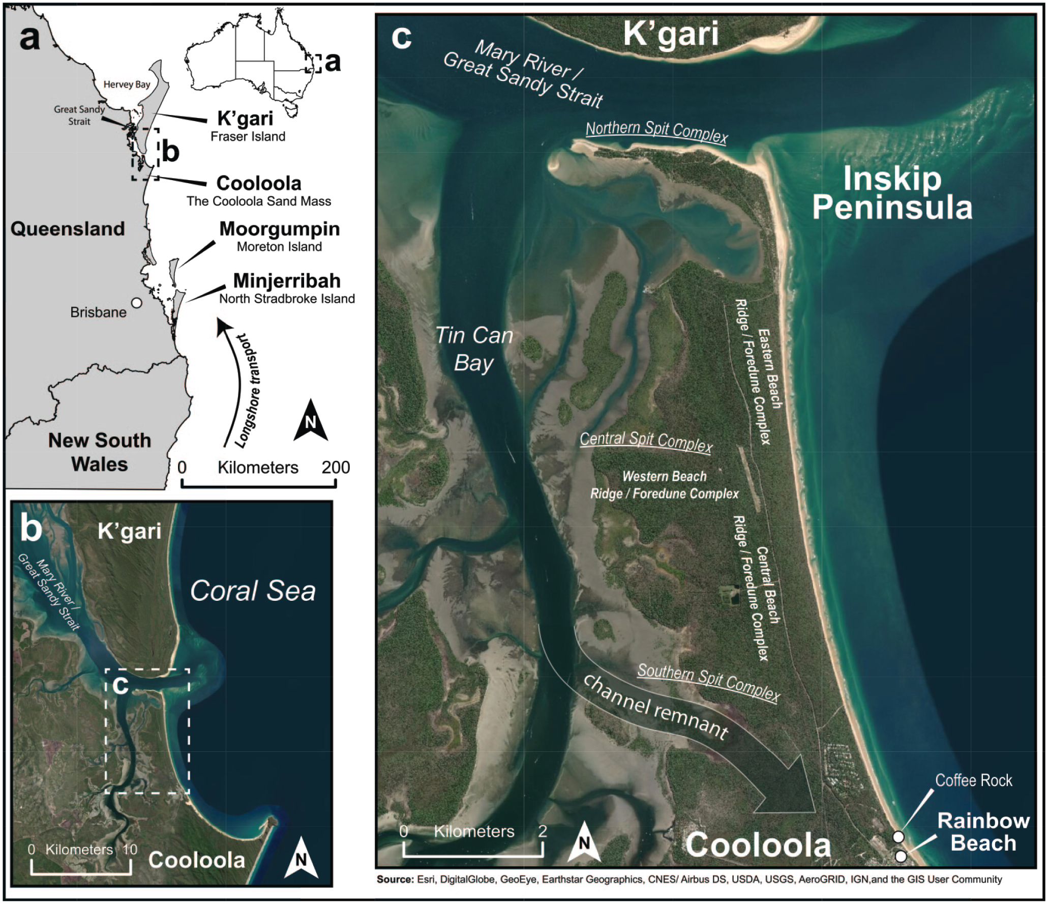
Location of Inskip Peninsula at the southern Queensland coast. (a) Main sand island/sand mass provinces of SE Queensland, with the field area (b) inset. (b) Image from DigitalGlobe showing the relative position of Inskip Peninsula (marked by box c) with the southern part of K’gari to the north. (c) Satellite image of Inskip Peninsula labeled with the major geomorphic features discussed in the paper.
Presently, the sand masses of K’gari and Cooloola are separated by a tidal channel and the Inskip Peninsula. While it has been proposed that the Cooloola Sand Mass and K’gari are part of the same dune field (e.g. Lees, 2006) that was divided by the Great Sandy Strait/Mary River channel during the last post-glacial sea-level rise, this has not been fully tested. Confirmation that K’gari and Cooloola are an interconnected system is important to decide if the Cooloola Sand Mass will be added to the existing Fraser Island (K’gari) World Heritage Area (Department of Environment and Science, Queensland Government, 2010). Here we present the Holocene evolution of Inskip Peninsula based on geomorphology, remote sensing, sedimentology, geochemistry and chronology from optically stimulated luminescence (OSL) dating.
The initial study of beach-ridge systems in Queensland was conducted by Hails (1964). He proposed a general model for spit and beach ridge development governed by longshore sediment transport and shore progradation. Subsequent studies in south-eastern Queensland and north-eastern New South Wales (e.g. Brooke et al., 2008; Hesp, 1983, 1988, 2002; Otvos, 2000; Scheffers et al., 2011) highlighted the use of beach ridges to reconstruct sea-level variability and changes in storm and wave energy. These studies extend as far north as Moreton Bay east of Brisbane (e.g. Gontz et al., 2013) but have not extended north into the region immediately south of the Great Barrier Reef. Inskip Peninsula lies in this ~500 km long data gap and is an excellent laboratory for studying beach and dune evolution, morphology and dynamics (Hesp, 2002), as beach ridge sequences are easily accessible. This work adds to recent wave climate and modern shoreline change studies in response to climate forcing from the immediate vicinity (Kelly et al., 2019; McSweeney and Shulmeister, 2018). Coupled with local sea-level change and wave climate variability, a detailed reconstruction of the peninsula can be made. In coupling the long-term millennial-scale Holocene evolution with modern wave data to infer a paleorecord based on shoreline orientation, this study contributes to studies about progradational systems in Australia and worldwide (e.g. Silva et al., 2020). The integration of paleo wave climate with additional insights on long-term changes in fluvial/tidal processes based on geomorphology was further used to determine control factors on barrier development. Inskip peninsula offers unique paleoenvironmental records of coastal change in the Holocene and this study further adds to recent studies of coastal paleorecords (e.g. Hein & Ashton, 2020; Oliver et al., 2017; Tamura, 2012; Tamura et al., 2019) and coastal progradation along the eastern Australian coast (e.g. Carvalho et al., 2019; Oliver et al., 2018, 2019). Knowledge gained from studies of Holocene sea-level changes and associated (littoral) response processes (e.g. coastal progradation, barrier breaching, or river avulsion) is highly important to predict changes of modern beaches.
Setting and physiography
Inskip peninsula is located on the east coast of Australia about 180 km north of the city of Brisbane, Queensland (Figure 1). It is a little over 12 km long, 3.5 km wide at its widest point and extends from −25.809° to −25.930°S and 153.044° to 153.111°E, covering an area of 18 km2. Inskip peninsula is a low-lying coastal feature (highest dune elevation is 18 m AMSL) and is largely composed of a spit, beach ridge and foredune complex, with some remnant parabolic dunes on the western side of the peninsula (Köhler and Shulmeister, 2019).
Inskip peninsula is affected by tidal and fluvial processes of the Great Sandy Strait, which consists of a linked system of estuarine channels, tidal inlets, tidal deltas and tidal flats between K’gari and the adjacent mainland (Figure 1). The strait extends for 70 km north to south and has a maximum width of 17 km near its northern end. The southern end of the Great Sandy Strait is comprised of the tidal Wide Bay Inlet (up to 1.5 km wide and up to 25 m deep) north of Inskip Peninsula (Figure 2). The main channel of the Mary River enters Great Sandy Strait approximately 45 km north from Inskip Peninsula through a tide dominated delta and introduces a large volume of fluvially sourced sediment to the western side of the Strait, which is then flushed by strong tidal currents seaward into Hervey Bay and to a lesser extent southward into the Great Sandy Strait toward Inskip Peninsula (Boyd et al., 2004; Stephens et al., 1988). Tin Can Inlet (Figure 2) drains the area behind the Cooloola dune field but has a much smaller fluvial input.
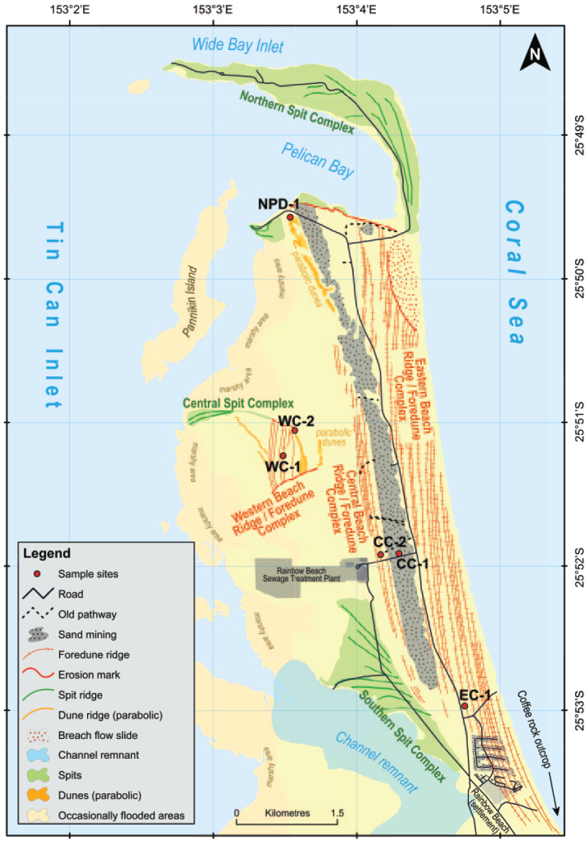
Geomorphological map of Inskip Peninsula (modified after Köhler and Shulmeister, 2019).
Inskip peninsula lies near the northern end of one of the longest longshore littoral sand accumulation system in the world (~1500 km along the east coast of Australia, Boyd et al., 2008). The sands that are delivered to the area are Mesozoic sediments from the tablelands of eastern New South Wales delivered to the coast by the Hawkesbury and Hunter Rivers (Colwell, 1982; Pye, 1983; Roy and Thorn, 1981; Thompson, 1981). Sand grains are dominantly quartz (98%) with ~2% heavy minerals, notably rutile, ilmenite, monazite, and zircon. Feldspars occur infrequently and carbonates are rare. The sands are generally well sorted and rounded, and are fine to medium in size (Thompson, 1981). Sand mining was conducted from 1966 to 1974 in the northern and central parts of the peninsula in the search for titanium (Supplemental Figure 6) and zirconium (Grimes, 1992). Today these former extraction areas are largely revegetated, although the mining impacts are clearly visible in historical imagery (Supplemental Figure 1) and on Digital Elevation Models (DEMs) (Köhler and Shulmeister, 2019).
The vegetation of the peninsula ranges from pioneer taxa trees such as Coast Banksia (Banksia integrifolia) and Australian Pine Tree (Casuarina equisetifolia) on the beach ridges/foredune complexes in the east to Pink Bloodwood (Corymbia intermedia) forest in the western inland. Broad-leaved Paperbark tress (Melaleuca quinquenervia) occurs in the swales of the foredune ridges and low ground in the west. Cypress-pines (Callitris) form pure stands on some beach ridges/foredune complexes (Köhler and Shulmeister, 2019; Thompson and Moore, 1984). Mangroves occur along marshy areas on the western side of the peninsula.
The peninsula has a Cfa humid sub-tropical climate under the Köppen climate classification system (Peel et al., 2007) with warm moist summers and mild dry winters, typical of continental east coasts between 20° and 35°N and S latitude. Dominated by flow around the sub-tropical high-pressure cell, the climate features moist, onshore SE airflows for most of the year, though NE conditions can occur, especially in summer. The dominant wind directions control the wave fields affecting the peninsula with normal swell conditions from the SE but highest energy waves coming from the NE (McSweeney and Shulmeister, 2018). The SE winds also control the dune orientations on the adjacent Cooloola and K’gari dune fields (e.g. Thompson, 1983).
The open ocean coast is micro-tidal to meso-tidal (max range just over 2 m), while Hervey Bay is meso-tidal with a maximum range above 4 m (https://www.msq.qld.gov.au/Tides/Tide-Tables). Consequently, a strong tidal current maintains the channel between Great Sandy Strait and the Coral Sea. The open-ocean wave climate of the Inskip Peninsula has a bi-directional wave field during both modal and storm conditions (McSweeney and Shulmeister, 2018). Storms generate (a) E-ESE moving wave fields associated with ex-tropical storms in the Coral Sea and (b) waves from the SSE that correspond with east coast lows (McSweeney and Shulmeister, 2018). Ex-tropical storms generally produce higher waves. The interaction between two large scale climate phenomena: El Niño-Southern Oscillation (ENSO) and Interdecadal Pacific Oscillation (IPO) influences wave climate variability in the Inskip region (Kelly et al., 2019; McSweeney and Shulmeister, 2018). During La Niña phases of ENSO, extra-tropical cyclonic activity increases due to higher sea-surface temperatures in the Coral Sea (Basher and Zheng, 1995). This drives an anticlockwise shift (i.e. more easterly) in wave direction and an increase in wave height. During El Niño periods, when sea-surface temperatures in the Coral Sea decrease, the wave direction rotates clockwise (i.e. becoming more southerly) and wave height decreases. Changes in wave climate are most pronounced during sustained (>6 month) La Niña phases where a +0.10 m increase in wave height and a 6° anticlockwise shift in direction can occur (McSweeney and Shulmeister, 2018). The IPO modulates the impacts of ENSO by controlling the position of the South Pacific Convergence Zone (SPCZ) (Power et al., 1999). During negative IPO phases, the SPCZ migrates closer to Australia and ENSO’s impact on the eastern Australia wave climate is amplified (Kelly et al., 2019; Splinter et al., 2012). During positive IPO, the SPCZ moves northeast away from Australia and the impacts of ENSO are dampened with the Subtropical Ridge becoming a driver of wave climate variability (Kelly et al., 2019). At the shoreline, this translates to ENSO influencing erosion/accretion only during negative IPO phases (Folland, 2002; Power et al., 1999; Splinter et al., 2012). Shifts in wave height and direction as influenced by the IPO’s modulation of ENSO have an important impact on sediment supply and shoreline behavior and thus potential to influence beach ridge evolution.
Data and methods
Geomorphological, sedimentological, and geochemical methods were utilized to reconstruct the late Quaternary landscape evolution of the Inskip Peninsula. Landforms were defined using a 1 m DEM and field mapping. Hillshade DEMs were obtained from the State of Queensland (Department of Environment and Resource Management) and are derived from aerial imagery using airborne laser scanning taken between July and September 2009. Aeolian and littoral landforms were mapped in ArcGIS and were utilized to investigate and interpret sloped features, notably the parabolic dunes and the foredune ridges (Köhler et al., 2019). In areas of the landscape with dense vegetation and abundance of water, DEMs were reaggregated to a 5 m resolution to reduce uncertainty and remove raster artifacts. Features were ground truthed in March 2017.
Field data
Individual sample sites were named based on their location and preliminary classification to simplify and standardize the labeling (NPD-1 at the Northern parabolic dunes; EC-1 at the Eastern beach ridge/foredune complex; CC-1 and CC-2 at the Central beach ridge/foredune complex; WC-1 and WC-2 at the Western beach ridge/foredune complex (Table 1)).
Map locations and associated OSL dating information (where applicable) for Inskip Peninsula.

Age analysis using the single-aliquot regenerative-dose procedure of Murray and Wintle (2000) on 1-mm small-aliquots of 150–250 μm quartz sand. Number of aliquots used in age calculation and number of aliquots analyzed in parentheses.
See Supplemental data for radioisotope concentrations of surrounding sediment and cosmic contribution to dose rate. A 7 ± 3 wt. % water content assumed for all samples.
Equivalent dose (DE) calculated using the Central Age Model (CAM) of Galbraith and Roberts (2012).
Note that measured water contents were all far below 1% as samples were collected in extreme drought conditions. A water content of 7% has been estimated for all samples.
In total, six boreholes were described; two collected via percussion coring and four by a ~30 cm bucket sand-auger with T-handle and rod extensions. The percussion cores were recovered from a relict beach ridge and a former spit in the southern part of Inskip peninsula, along the access track to the Rainbow Beach Sewage Treatment Plant (sites CC-1 and CC-2) (Figure 3). Hand augers (Supplemental Figure 6) were used to collect borehole samples from dune remnants and beach ridges in other parts of the peninsula, see Table 1 and Figure 3. The coring and augering covered all major landform types. Sampling depths were limited by the very dry conditions with sample retention being a major challenge. The deepest hand augering was achieved on the Western beach ridge/foredune complex (367 cm).

Morphology of Inskip Peninsula and soil profiles. (a) Digital elevation model of Inskip Peninsula and sampling points. OSL ages in ka. (b) Idealized and 30-fold exaggerated transects with soil profiles below, the dashed hill with sample NPD-1 is projected onto the line of survey. (c) Displays the southern part of the peninsula highlighting the location of a continuous low area that we interpret as a paleochannel (see Supplemental Figure 8 for more detail). This is the inferred position of the mouth of Great Sandy Straight in the early (early-mid) Holocene. The Holocene history of the Peninsula is focused around the northward migration of the peninsula and the mouth of the channel connecting Great Sandy Straight to the Coral Sea.
Auger and core sections were subsampled and analyzed for Munsell color, particle size, grain-surface characteristics, and geochemistry. Grain-size measurements were completed on a Malvern Mastersizer 3000 laser diffraction particle size analyzer and analyzed with GRADISTAT version 8.0 (Blott and Pye, 2001) using the Folk and Ward (1957) method (Supplemental Table 1). Grain-surface characteristics were identified using a Hitachi TM3030plus scanning electron microscope (SEM), at 40× to 400× magnification. Grain roundness, sphericity, and surface texture (Supplemental Table 1) were classified following Tucker (1988). The elemental composition of 117 sediment (sub-) samples were measured with a handheld Niton XL3t XRF Analyzer and using a Quantax 70 Energy Dispersive X-ray (EDX) Spectrophotometer attached to the SEM (Supplemental Figures 3, 4 and 6).
Age control
Age control was obtained using optically stimulated luminescence (OSL) dating of quartz sand (Huntley et al., 1985). OSL dating provides an age estimate of the last time sediment was exposed to light and therefore provides the direct age of sediment burial and landform development (e.g. Rittenour, 2018). OSL samples were collected from at least 2 m depth to provide constraining age for the geomorphic features sampled and to minimize the effects of post-depositional mixing from soil development and bioturbation, which can cause age under estimates due to resetting of the luminescence signal (e.g. Bateman et al., 2007). Light-safe OSL samples were collected from auger holes using an aluminium tube inserted in the sample head and from the cores by sub-sampling in a darkroom laboratory.
OSL samples were processed at the Utah State University Luminescence Laboratory using the single-aliquot regenerative dose (SAR) method on small aliquots (~10 grains) of quartz sand (Murray and Wintle, 2000). Sample preparation to isolate fine-grained quartz sand (180–250 µm) followed standard procedures and included sieving to isolate the target grain size, treatments with HCl and H2O2 to remove carbonates and organics, heavy mineral separation (2.7 g/cm3 sodium polytungstate), and HF to remove feldspars and etch the quartz grains.
OSL ages are calculated by dividing the equivalent dose of radiation the sample received during burial (DE, in Grays, Gy) by the dose-rate environment of the surrounding sediments (DR, Gy/Kyr). Representative samples for dose-rate determination were collected from sediments above, below, and within the OSL sample intervals to provide good estimates of dose rate exposure of the samples. Dose rates were calculated using ICP-MS and ICP-AES techniques to determine K, Rb, Th, and U and conversion factors from Guérin et al. (2011). Due to local drought conditions, in situ moisture contents were very low (0.6%) and considered non-representative as droughts of this intensity are rare in this region and water contents of 5–7% have been applied at the adjacent Cooloola Sand Mass (e.g. Ellerton et al., 2020). Consequently, 7 ± 3% water content was assumed to be representative for the lifetime of the samples. Dose rates were calculated based on sediment chemistry, attenuation due to water content (Aitken, 1998; Aitken and Xie, 1990), and include the contribution of cosmic radiation based on present sample depth (Figure 4), elevation, and latitude/longitude following Prescott and Hutton (1994). Dose rate values and data used for calculation are presented in Supplemental Figure 2.
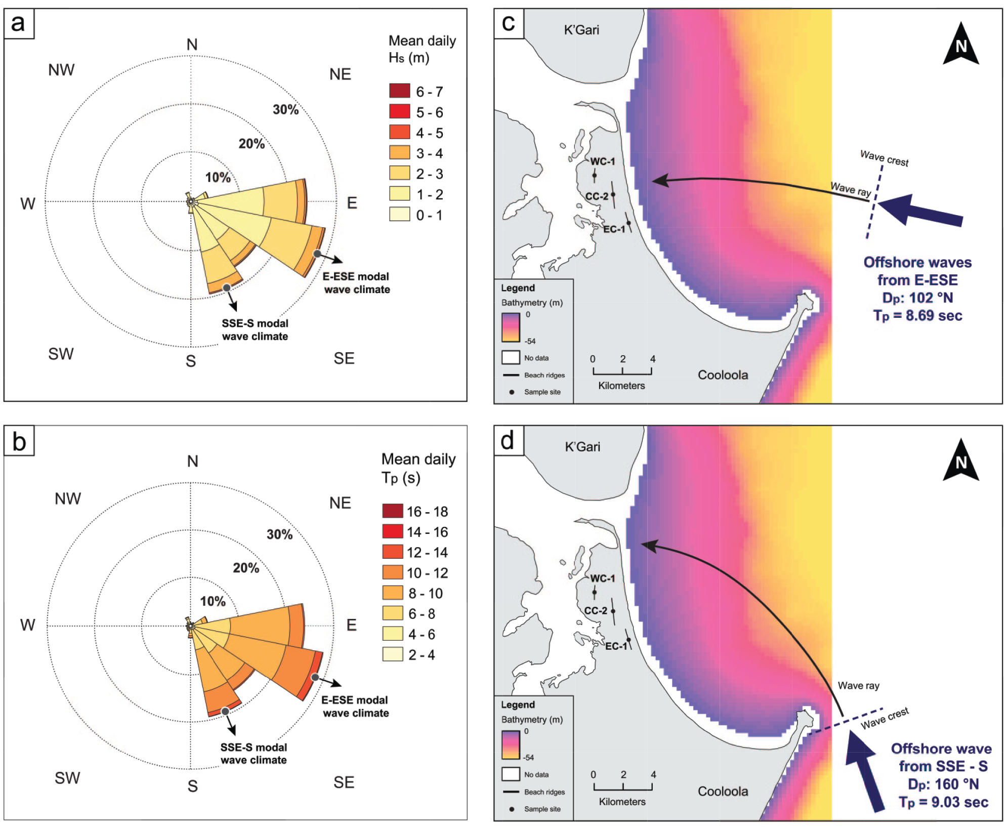
Wave climate of Inskip peninsula. (a) Wave direction-significant wave height (Hs) rose for modal wave conditions offshore of Inskip Peninsula showing bimodal peaks from the: E-ESE and SSE-S. (b) Wave direction-peak wave period (Tp) rose. (c) Refraction diagram for E-ESE mode using median offshore incident wave direction (Dp) and Tp. Refraction calculations were plotted at 5 m contour intervals from deep water to 2 m water depth. (d) Refraction diagram for SSE-S modal wave conditions using median offshore incident Dp and Tp.
Luminescence measurements were performed on Risø TL/OSL Model DA-20 readers with blue-green light emitting diodes (LED) (470 ± 30 nm) as the stimulation source. The luminescence signal was measured through 7.5 mm UV filters (U-340) over 40–60 s (250 channels) at 125°C with LED diodes at 45 mW/cm2 and calculated by subtracting the average of the last 5 s (background signal) from the first 0.7 s (four channels) of the signal decay curve. Preheat temperatures prior to the measurement of the natural and regenerative doses were 200°C for 10 s and cut-heat treatments were 160°C for 10s. The luminescence signals show rapid decay dominated by the fast component of the signal, indicating the samples are suitable for dating (Murray and Wintle, 2003). In light of the young ages of the samples, DE values were calculated using a linear fit between the zero dose and repeated first regenerative doses of the dose-response curve.
Equivalent dose values were calculated using the central age model (CAM, Galbraith and Roberts, 2012) using at least 16 accepted aliquots. Aliquots were rejected if they had evidence of feldspar contamination, a recycling ratio beyond ±10% of unity or poor dose-response curve fit. Errors on DE are reported at two-sigma standard error (2σ) and ages are reported at 1σ (Table 1). Errors were calculated in quadrature using the methods of Aitken and Alldred (1972) and include uncertainty related to instrument calibration, dose-rate determination, and equivalent dose calculation.
A supplemental age validation was determined by characterizing dunes into morphosequence units following the methods of Patton et al. (2019). Their semi-automated mapping approach uses topographic indices of individual dunes (i.e. surface roughness, curvature and slope), coupled with geomorphic features (i.e. cross cutting and on lapping relationships) to classify into units, see Patton et al. (2019) Table 1. Dated dunes at the nearby Cooloola Sand Mass have shown strong correlation between these morphosequence units with age and subsequently been placed into age brackets (Ellerton et al., 2020), thereby providing an approximate age validation. Any significant age deviations between the morphosequence classifications and our OSL dates might reflect reactivation of the landscape since original dune emplacement or the sampling of redeposited sediments. No organic material for radiocarbon dating was recovered, which limited the study to age determination by OSL dating and morphosequence age validation.
Wave field calculations
Finally, to test the influence of changing wave direction on shoreline accretion/erosion and ridge alignment, the distribution of modern-day modal wave conditions was extracted 65 km offshore of Inskip Peninsula (−25.90°S, 153.73°E, in >25 m water depth) using the hindcast wave dataset (combined sea and swell) of McSweeney and Shulmeister (2018), sampled at a 3-hourly frequency over 31 years (1979–2009). The median wave direction (Dp), offshore significant wave height (Hs), and wave period (Tp) associated with each directional peak were extracted. Using Australian Bathymetry and Topography Grid datasets (Whiteway, 2009), contours were constructed offshore to 45 m water depth and using Snell’s Law, waves were refracted onshore to determine changes in wave angle relative to the modern shoreline. The methods of wave hindcasting and analysis are described in detail by McSweeney and Shulmeister (2018).
Results
Field data
The distribution of landform assemblages of the Inskip Peninsula and summary core and auger information are presented in Figures 2 and 3. The Peninsula can be divided into three parts; an eastern section dominated by numerous beach ridges with their attendant foredunes and with an active spit at the northern limit of the peninsula, a central section composed of broader beach ridges with foredunes and with parabolic dunes locally extending from the beach ridge area, and a western section comprising truncated remnants of higher beach ridges and parabolic dunes. Again, foredunes are associated with the beach ridges in most instances. Spits are also a common feature on the peninsula with three distinct groups in the north, center, and southern peninsula. Each relates to different phases of development of the peninsula.
The highest beach ridges/foredune complexes are 8–10 m AMSL in the Western Beach Ridge Sequence. All other beach ridges complexes are lower, ~7 m AMSL along the Central Beach Ridge Sequence and 6–7 m AMSL in the Eastern Beach Ridge Sequence. Spit deposits are lower still (within a meter or so of modern sea level). The parabolic dune remnants are of a similar elevation to the higher beach ridges complexes (around 11 m in the central part of the western peninsula) and significantly higher in the NW corner (e.g. NPD-1; 17 m AMSL). These parabolic dunes are not fully preserved.
All sediment samples are composed of fine to medium well-sorted quartz sands with minor amounts of heavy minerals. Grain-size distributions are symmetrical (unskewed) and mesokurtic in general, which is typical for beach sediments and dune sands, but can be leptokurtic in certain ridges (e.g. WC-1, EC-1) which suggests an aeolian source. Soils are all aeric podosols or incipient aeric podosols. The depth to the Bhs horizon (B horizon dominated by organic-metallic, aluminium and iron compounds, cf. Isbell, 2002) in the center and west of the peninsula range from about 90 cm (CC-1) to a uniform 120–140 cm (CC-2, WC-1, NPD-1). Coring east of the main road was very difficult due to the excessively dry conditions; the one successfully augered borehole (EC-1) indicated an A horizon over a C horizon. All samples are characterized by high fluctuations in grain roundness and sphericity, and there is no uniform trend for individual morphological units. Moreover, grain-surface textures are also very heterogenous. The samples contain strongly rounded grains with etched surfaces, smoothed fracture marks, low relief and strong curved scratches as well as sharp-edged grains with edgy fracture marks, high relief, and fresh scratches. Cracked grains with numerous fresh large conchoidal features or percussion marks are results from very energetic, subaqueous conditions during storms (c.f. Costa et al., 2012; Gutiérrez-Mas et al., 2003; Kalińska-Nartiša et al., 2018). Conversely, quartz grains with matte surfaces (smoothed fracture marks, low relief) suggest subaerial environment with a predominance of aeolian factors (c.f. Kalińska-Nartiša et al., 2018; Vos et al., 2014). Summary Folk and Ward (1957) statistics, grain roundness, and elemental compositions are presented in Supplemental Table 1.
OSL results
OSL ages are summarized in Table 1. These results suggest that all surficial features are Holocene in age. As expected based on the cross-cutting and geomorphic relationships the oldest parts of the peninsula are the Western beach ridge/foredune complex (WC-1, WC-2) and the associated parabolic dunes. An OSL age of 8.83 ± 0.79 ka (WC-1) suggests an early to middle Holocene age and highlights the possibility of lower sea-level conditions for these beach ridges. Central beach ridge/foredune complex (CC-1, CC-2), which lies several 100 m to the east of the Western beach ridge/foredune complex, has consistent ages of 6.67 ± 0.64 ka (CC-2) and 6.02 ± 0.61 ka (CC-1), indicating higher sea-level conditions. The parabolic dune remnant in the NW corner of the main peninsula yielded an age of 4.84 ± 0.46 ka (NPD-1). This younger age is expected as these dunes stratigraphically overly the Central beach ridge/foredune complex.
Wave field results
The analyses of wave data demonstrate an E-ESE mode and SSE-S mode (Figure 4a and b). Waves from the E-ESE are most common overall offshore of the Inskip Peninsula. Waves incident from the E-ESE approach the shoreline at 8° and waves from the SSE-S approach at 18°. This equates to a more oblique wave climate under the SSE-SE mode, whereas waves from the E-ESE approach near-normal to the shoreline. Changes in modal wave direction and the associated differences in longshore sand flux may therefore drive periods of shoreline erosion and accretion at the receiving shoreline of Inskip peninsula. When compared to the orientations of the beach ridges incorporated in WC-1 (358°N), CC-2 (352°N) and EC-1 (346°N), WC-1 and CC-2 are most similar and are more closely aligned with waves from the E-ESE. WC-1 and CC-2 have offshore orthogonals of 88° and 82°N.
Discussion
Geomorphic evolution of the peninsula
The development and evolution of Inskip Peninsula can be reconstructed from the sedimentologic, geochronologic, and geomorphic records (Figures 2–4). The peninsula can be divided into three regions based on their relative ages, their dominant topography, and their developmental processes. The west-central portion of the peninsula contains an erosional wedge-shaped remnant of high beach ridges (WC-1 and WC-2) and parabolic dunes we name the Western beach ridge/foredune complex. The northern and southern sides of this block are delimited by erosional cuts that indicate that a broader region of beach ridges was trimmed by wave erosion and roughly east-west oriented tidal flows. We suggest that the margins of this feature define the positions of former tidal channels where combined water from Tin Can Bay, the Great Sandy Strait and the Mary River entered the Coral Sea. The Central beach ridge/foredune complex contains a series of high beach ridges (CC-1 and CC-2) and overlying parabolic dunes (NPD-1). The eastern coastal region, closest to the modern shoreface, contains numerous narrow foredune ridges (e.g. EC-1) and swales (lee dune depressions) of the Eastern beach ridge/foredune complex. Observed spits include the older remnant Southern and Central Spit Complex and the modern Northern Spit Complex.
Initially, we considered that part of Inskip might be a Pleistocene remnant (Köhler and Shulmeister, 2019) based on the relatively well-developed aeric podosols across the field area (1.2–1.4 m depth to Bhs Horizon) and soil development rates from Ward (2006). The OSL dating demonstrates otherwise and confirms clear Holocene ages (WC-1: 8.83 ± 0.79 ka, NPD-1: 4.84 ± 0.46 ka). It corroborates work from Cooloola (e.g. Ellerton et al., 2020; Thompson, 1981; 1992) suggesting that podosols this thick can form within 5–10 ka in these freely drained sands and humid subtropical climate. The Holocene OSL ages are confirmed by predicted morphosequence age ranges following the methods of Patton et al. (2019). The northern NPD-1 dune was placed in the Freshwater morphosequence which spans from 3.5 to 4.9 ka (Ellerton et al., 2020) due to its sharp dune crest, fully develop podzol soils, and topographic indices (mean slope = 16.7 ± 10.0 m*m−1 and standard deviation of curvature = 0.02 m−1) which falls within the Freshwater dune morphosequence from Cooloola (Patton et al., 2019;
The Holocene coastal evolution of Inskip Peninsula is closely related to the northward migration and instability of the Great Sandy Strait connection to the Coral Sea. This northward migration is due to longshore sediment transport and strong sediment supply from the south gradually pushing the channel northwards (Figure 5). Evidence for the changes are: (a) The existence of a low channel on the western side of the base of the Peninsula close to Rainbow Beach township that marks the early Great Sandy/Mary river position (Figure 3 and Supplemental Figure 8). This southernmost position of the early Holocene (> 9 ka) outlet of Sandy Strait was likely controlled by the coffee rock outcrop at Rainbow Beach (Figures 1 and 5a). (b) Spits on the southern part of the western side of the peninsula document northward extension of Inskip in the mid-Holocene (Figure 5b). (c) Evidence for intermediate positions of the Sandy Strait mouth are provided by the shallow cuts on the southern and northern sides of the western sediment wedge (Figure 5c and d). The mouth of Great Sandy Strait then migrated close to its modern position. Many river mouths display this sort of migratory behavior (e.g. Chaumillon et al., 2014; Shulmeister and Kirk, 1997) but the volume of (recent) sediment transport from the south is exceptional in this case (~500,000 m3, Boyd et al., 2008) and while the channel can still avulse, evidence suggests that it has been located close to its modern (northern) position for the last c. 5 ka or more. There is evidence from erosional scarps and truncated spit remnants for several phases of spit extension and erosion (Figure 5e and f). Spit breaching is likely to be associated with storm events (Chaumillon et al., 2014). These processes continue to the present day.

Inskip peninsula development featuring seven consecutive episodes. (a) Paleo peninsula/barrier system (>7 ka). (b) Erosion by Great Sandy Strait/Mary River mouth shifting northward (c. 7 ka). (c) Spit building and further northward migration (<7 ka). (d) Formation of central beach ridges and parabolic dunes (7-4.8 ka). (e) Progradation of eastern beach ridges (<4 ka) creating the overall modern peninsula form. (f) Erosion of northern part/spit complex after 4.8 ka. (g) Formation of northern (recent) spit and small breach flow slide (last millennium).
We provide a step-by-step reconstruction of the evolution of Inskip Peninsula below:
>7 ka – Inskip Peninsula
Geomorphic cross-cutting relationships indicate that the oldest landforms on the peninsula are found within the Western beach ridge/foredune complex which was likely connected to K’gari (WC-1) (Figures 2, 3, and 5a). The morphology of this area is dominated by beach ridges that are aligned sub-parallel to the modern east coast (~N–S). The major process operating in the mid-Holocene along Inskip is the realignment of the mouth of the Mary River/Great Sandy Strait. There is morphological evidence in the form of a channel remnant that suggests a former passage between Tin Can Bay and the open sea just north of Rainbow Beach Township (Figure 5a), and its migration northward preserved as a series of spit complexes (Figure 3). This migratory behavior matches observations of delta mouth movements under littoral drift in modeling studies (Nienhuis et al., 2016).
~7 ka – Inskip Peninsula
During the early part of the Holocene maximum sea-level transgression (~7 ka; Parham et al., 2014), the mouth of the Mary River/Great Sandy Strait moved north, truncating the southern portion of the Western beach ridge/foredune complex whilst forming the Southern Spit Complex (Figure 5b). Geomorphic and chronologic evidence suggests that truncation of the Western beach ridge/foredune complex occurred sometime after c. 8.8 ka but before the establishment of the Central beach ridge/foredune complex (CC-1) at about 6.7 ka. During spit formation, there was an opening between the spit and the Western beach ridge/foredune complex remnants to the north and it is almost certain that this connected to K’gari at this time. This opening explains the recurved spit limbs as a result of wave and tidal interactions similar to the recent larger recurved spit in the north of the peninsula (Northern Spit Complex).
OSL results (8.83 ± 0.79 ka) from the older and higher truncated beach/foredune ridges in the Western Beach Ridge Complex at c. 8–10 ka pre-date the regional Holocene sea-level maximum. While these beach ridges are aligned sub-parallel to the modern east coast, they are 3–4 m higher than the younger beach ridge/foredune complex to the east. There are two options for its formation. First, these high beach and dune ridges may represent the early Holocene western side beaches of a lake that used to occupy part of the Inskip area. Lakes are common on K’gari and many lakes and abandoned lakes have active and/or relict beaches on their margins. A significant problem with this idea is that the primary location of formation of beaches is facing the prevailing wind – that is, a SW-NE alignment on the NW side of the lake. These beaches are aligned roughly N–S, which is oblique to both paleo-and modern wind direction (e.g. Ellerton et al., 2020). We regard this observation as a critical flaw of this hypothesis.
Second, and our preferred option, is that the formation of the Western Beach Ridge Complex occurred during the Holocene sea-level maximum. This is estimated to be 2 m above modern MSL (Lewis et al., 2013) but also younger than 8 ka. We note that the OSL age errors are 1-sigma only and that within a 2-sigma error, the ridges could be consistent with an early mid-Holocene high stand. Additional elevation differences could be explained by higher wave energy at the time of Western beach ridge/foredune complex development and/or by an increase in tidal range associated with a larger tidal prism during the onset of the high sea-level stage. The early Holocene and especially the period around 9–6 ka is a regional precipitation maximum in eastern Australia (e.g. Woodward et al., 2014) and this was likely associated with enhanced summer rainfall, which implies NE flows and warmer sea-surface temperatures in this area. These conditions would support higher storm energy wave fields (McSweeney and Shulmeister, 2018) and increased dune activity and thereby higher beach and foredune ridges (c.f. Ciarletta et al., 2019; Oliver and Tamura, 2021; Psuty, 2008). This supposition is supported by the fact that other controls on beach ridge elevation such as wave fetch are impossible to modify significantly. Nevertheless, we acknowledge that there is a degree of special pleading in this argument.
7–6.7 ka – Inskip Peninsula
Subsequently the mouth of Great Sandy Strait avulsed north of the Western beach ridge/foredune complex remnant trimming the northern margin of this beach ridge set while building the Central Spit Complex (Figure 5c). The old channel to the south would have been abandoned quickly due to the shorter hydraulic length of the northern channel and sediment infilling due to longshore sediment transport from the south. These events are undated but younger than the Western beach ridge/foredune complex (WC-1; 8.83 ± 0.79 ka), and older than the Central beach ridge/foredune complex to the east (CC-2; 6.67 ± 0.64 ka). The higher beach ridges of the Central beach ridge/foredune complex formed on top of the Southern Spit Complex and cover its eastern part.
River avulsion was essential in preserving the Western beach ridge/foredune complex, since river mouth migration (rather than avulsion) would presumably eliminate this oldest part of the peninsula. The preservation of this unique paleoenvironmental record of coastal change is therefore directly linked to the partially river-controlled setting.
6.7–4.8 ka – Inskip Peninsula
The Central beach ridge/foredune complex (CC-1 and CC-2) formed after the closing off of the channel in the southern part of Inskip and the rotation of the coast into swash alignment (Figure 5d). OSL ages suggest that this beach ridge set formed between 6.67 ± 0.64 and 6.02 ± 0.61 ka. The initial beach ridge/foredune complex emplacement was followed by an eastward decline in elevation of this beach ridge sequence, suggesting a gradual coastal progradation under falling relative sea levels and/or increased sediment supply. We note that numerous sea-level indicators indicate that sea level fell ~1 m along the eastern Australian coast between 5.5 and 4.5 ka (Lewis et al., 2008, Sloss et al., 2018). Geomorphic evidence suggests that by this time the main channel between Great Sandy Strait and the Coral Sea was located close to its modern position at the northern end of the peninsula. Small parabolic dunes developed off the western margins of the Central beach ridge/foredune complex. The best developed of these dunes (NPD-1) yielded an age of 4.84 ± 0.46 ka which may reflect either the longer-term stability of a coast at the Central beach ridge/foredune complex position or, more likely, a local reworking of the dunes at about 5 ka. We discuss the age of the dunes further below.
Assuming ridge deposition occurs under near-normal, modal wave conditions (Scheffers et al., 2011; Taylor and Stone, 1996), this is closely linked to the refracted E-ESE waves that approach the shoreline at 8°. These observations suggest that sea-surface temperatures in the mid-Holocene were on average warmer, at least in the summer storm season.
4.8 ka – near modern Inskip Peninsula
A second, lower set of beach ridges (Eastern beach ridge/foredune complex) is found to the east side of Inskip Point Road (Figure 5e). While not dated, geomorphic relationships indicate that these beach ridges (EC-1) are younger than the Central beach ridge/foredune complex (CC-1 and CC-2) and since a parabolic dune was developed off the central beach ridge foredune complex stabilizing at about 4.8 ka, the eastern ridges are likely to be younger than this age.
EC-1, has an offshore orthogonal of 76°N, and is less well aligned with waves approaching from the E-ESE than the earlier beach ridges. In fact, there are a series of beach ridge orientations in the Eastern beach ridge/foredune complex. All are more oblique than the older central and Western beach ridge complexes. This indicates a shift in sediment supply and/or model wave direction in the late-Holocene. Episodic changes in coastal ridge orientation have also been noted in the late-Holocene from northern New South Wales (Goodwin et al., 2006) to the south of the study area. Goodwin et al. (2006) presented a summary of modal inner-shelf wave direction changes for the past 3000 years also based on foredune ridge alignment. They observed several changes in coastal alignment and concluded that there is no significant change in sand supply during the late-Holocene in NE New South Wales. As the two areas are part of the same longshore sediment transport system, this supports the hypothesis that the observed changes here are also dominantly due to changes in local wave climate.
The variable ridge orientations on Inskip likely reflect periods of alternating wave direction dominance occurring over the last c. 5 ka related in part to the intensification and increased variability of ENSO after the mid-Holocene (e.g. Donders et al., 2007; Roberts et al., 2014; Shulmeister and Lees, 1995). Changes in IPO may also play a role, as interactions between the IPO and ENSO have been demonstrated to remain in phase and to amplify each other over the last c. 400 years (Verdon and Franks, 2006), but the longer-term millennial history of the IPO is much less well understood. We note, however, that both ENSO and IPO are shorter term phenomena than the centennial to millennial-scale alternations of beach ridge orientation and we argue that the ridge orientations reflect longer term changes in modal conditions rather than individual ENSO or IPO events. A limitation of this study is that because of drought conditions, it was impossible to retain sand from the younger ridges in augers and we were unable to date the different phases of dune orientation from these eastern ridges. Nevertheless, the patterns observed here demonstrate that wave climate histories can be extracted from these younger beach ridge and foredune systems. This is a target for future work.
Present Inskip Peninsula
At the northern end of the peninsula most of the eastern ridges are truncated at or close to the modern beach (Figure 5f and g). The youngest and most easterly ridges were eroded before new beach ridges formed in front of them. Truncation of the northern part of the Inskip Peninsula perpendicular to the beach ridges suggests that another major erosion event occurred following the formation of the main Eastern beach ridge/foredune complex (Figure 5f). Due to persistent longshore currents and sediment supply, a new recurved spit (Northern Spit Complex) was built at Inskip’s northern margin, separating Pelican Bay and the Tin Can Inlet. The sediments used in building this spit likely have a mixture of fresh material accumulated by longshore currents and eroded material from the younger beach ridges. Because these sands are virtually identical, it is not possible to distinguish between the sources. This youngest part of Inskip Peninsula is particularly prone to sediment movements, as recent breach flow slides (vernacular: landslides) in 2015 and 2019 demonstrate (c.f. Alhaddad et al., 2020). The modern Inskip Spit is a highly dynamic feature fed by longshore sediment transport but extremely susceptible to toe undercutting by changes in tidal flow patterns between K’gari and Inskip (Figure 5g).
Connection of Cooloola Sand Mass to K’gari
Geomorphic evidence suggests that the Great Sandy Strait/Mary River connection to the Coral Sea was located at the southern end of the Inskip Peninsula during the Early Holocene (see Figure 3). This implies that the western part of Inskip Peninsula was actually part of K’gari and not the Cooloola Sand Mass at that time. The drowned valley that is now Tin Can Bay (the estuary of modern Carland, Snapper, Mullen, Teewah, and Teebar Creeks) likely formed during the last sea-level lowstand. These observations are important because they imply that the Cooloola Sand Mass to the South is effectively a continuation of the K’gari dune field to the north. K’gari comprises of the Fraser Island World Heritage Area and there have been ongoing discussions as to whether the World Heritage Area should be extended to include the Cooloola Sand Mass to the south. Both dune fields share many of the same dune characteristics, including exceptional age and completeness of coastal dune sequences, rainforest on dunes, and the world’s thickest soils. This study highlights that the absence of dunes in the intervening area is largely a function of erosion associated with the migration of the Great Sandy Strait mouth to the Coral Sea and reinforces the inference that Cooloola and K’gari are one system.
Inskip Peninsula itself highlights the geological processes of spit formation and channel avulsion in an exceptional manner. Barrier systems, including spit and barrier complexes such as Inskip, are highly responsive to changes in sea level, storminess, and sediment supply (e.g. Raff et al., 2018: Robin et al., 2020). Over the course of the Holocene, this system has been affected by all three processes, with the addition of strong tidal influences. In contrast with observations in hyper-tidal areas, where the tidal range plays an important role in controlling changes in the barrier system due to high tide and storm events (Robin et al., 2020), there is little direct evidence of tidal influence in changes in the main ridges. The long-term migration of the spit/barrier system northwards under the influence of littoral sediment transport matches both field and modeling observations of changes in barriers associated with riverine inlets (e.g. FitzGerald et al., 2002; Nienhuis et al., 2016). The strong tidal prism between Great Sandy Strait/Hervey Bay to the west and the Coral Sea to the east maintains a wide channel between Inskip Peninsula and K’gari to the north. What is perhaps the most remarkable feature of Inskip Peninsula is the comparative stability of the system. Since the stabilisation of the barrier-spit system in the mid-Holocene, coastal changes have been confined to the region of the tidal channel, which is highly unstable, and minor changes to the position and orientation of the younger beach ridges. This stability appears to reflect a relative stability of wave energy and long-term sediment supply to the system. The changes in orientation of the younger beach ridges is consistent with changes in the wave directions that still dominate this coast (McSweeney and Shulmeister, 2018) and give insights into changes in modal climate conditions.
Most spit-barrier complexes are subject to periodic breaching during storms at the point where the river channel entrance meets the sea. This results in the destruction of earlier barrier spit systems. Because the original entrance to Great Sandy Strait was on the southern end of the Inskip Peninsula at Rainbow Beach and the avulsion of the tidal mouth northward has increased the hydraulic gradient between Great Sandy and the Coral Sea by reducing the flow path distance, there has been little possibility for the mouth to move south again. This has resulted in the remarkable preservation of a series of Holocene spits and barriers.
The preservation of exceptional examples of a geological process (coastal evolution of a spit-barrier complex), the importance of the Peninsula in the history of the Fraser Island World Heritage Area and the significance of the peninsula to linking the Cooloola Sand Mass to the K’gari dune fields suggests that the Inskip Peninsula itself should be considered for World Heritage listing if and when such a listing is considered for the Cooloola Sand Mass.
Conclusions
Our results suggest that Inskip Peninsula was formed in the Holocene and is related to the interaction between the Mary River/Great Sandy Strait and northward long-shore transport of sediment along the eastern coast of Australia. The Peninsula began to form by about 8 ka as the post-glacial transgression pushed the coastline back into this area. An initial barrier system formed in the western part of the peninsula at a time when the Mary River/Great Sandy Strait reached the Pacific just north of Rainbow Beach. Subsequently this channel migrated north through a series of avulsions to close to its modern position. This occurred by 5 ka at the latest, but most likely by the formation of the Central beach ridge/foredune complex around c. 6.7–6.1 ka. The parabolic dunes formed at about the same time and have been subject to reworking at about 5 ka. The spit area at the northern end of the peninsula has been formed and destroyed several (possibly numerous) times in the mid- to late Holocene.
All the Western and Central beach ridge complexes formed under dominantly ESE-E oriented waves. The beach and foredune sequence on the eastern side of the Peninsula is undated but is late-Holocene in age. These foredune and beach ridges reflect periods of alternating wave dominance in the last 5 ka reflecting changes in wave orientation between the ESE-E and SSE-S. Though undated, the patterns are similar to those observed further south by Goodwin et al. (2006) in Northern New South Wales, but this late-Holocene sequence warrants further investigation.
Supplemental Material
sj-pdf-1-hol-10.1177_09596836211019092 – Supplemental material for Holocene evolution of a barrier-spit complex and the interaction of tidal and wave processes, Inskip Peninsula, SE Queensland, Australia
Supplemental material, sj-pdf-1-hol-10.1177_09596836211019092 for Holocene evolution of a barrier-spit complex and the interaction of tidal and wave processes, Inskip Peninsula, SE Queensland, Australia by Martin Köhler, James Shulmeister, Nicholas R Patton, Tammy M Rittenour, Sarah McSweeney, Daniel T Ellerton, Justin C Stout and Heiko Hüneke in The Holocene
Footnotes
Acknowledgements
We respectfully acknowledge the traditional owners of the land, the Butchulla and Gubbi Gubbi people. We thank Dylan Cowley and Helen Bowyer for assistance during fieldwork and Dr. Linda Nothdurft, Dr. Kevin Welsh, and Michael Tobe for assistance during the laboratory work. Thanks also to Dr. Henrik Rother, who initiated the research collaborations. The authors gratefully acknowledge the comments of Dr. Edyta Kaļinska-Nartiša, Dr. Sytze van Heteren, Dr. Craig Sloss, and three anonymous reviewers, which led to substantial improvement of the manuscript.
Funding
The author(s) disclosed receipt of the following financial support for the research, authorship, and/or publication of this article: Funding for this study was provided by the Australian Research Council (ARC) grant number DP150101513.
Supplemental material
Supplemental material for this article is available online.
References
Supplementary Material
Please find the following supplemental material available below.
For Open Access articles published under a Creative Commons License, all supplemental material carries the same license as the article it is associated with.
For non-Open Access articles published, all supplemental material carries a non-exclusive license, and permission requests for re-use of supplemental material or any part of supplemental material shall be sent directly to the copyright owner as specified in the copyright notice associated with the article.