
Abstract
Human Colonization of new lands implied historically the diffusion of new plant species and the exploitation of local plant resources and forests by human communities. Phoenician colonization in the 1st millennium BC had important consequences in Mediterranean agriculture and the exploitation of vegetation in colonized areas. Later, Roman agriculture introduced new changes. The anthracological analysis or charcoal analysis of the archaeological record of the site of Utica can inform us about the long term transformations in vegetation in North Africa. The original vegetation, consisting mainly of Pistacia lentiscus, would see its population reduced due to the implantation of non-intensive olive production in Phoenician and Punic periods. Nevertheless, since the Roman Imperial Period there was a strong decline of natural vegetation, in correlation of the important increment of olive trees, which indicate the presence of intensive oil production, mainly to be exported to Rome. Furthermore, the appearance of walnut trees presents novel data regarding the expansion of arboriculture throughout the Mediterranean in hand with the Phoenicians during the 1st millennium BC. The anthracological analysis of Utica presents important information regarding the natural vegetation that existed when the Phoenicians arrived, and the transformation that happened throughout time, corresponding to the management of the surrounding landscape during the Phoenician, Punic, and Roman periods.
Introduction
By means of anthracology we can know the flora and the composition of the different vegetation groups that existed in the past, both at local and regional levels. In this sense, large general summaries of large areas, such as the Western Mediterranean (Vernet and Thiebault, 1987) have been made, though other areas, such as the North of Africa, due to the scarce amount of studies that have taken place (Neumann, 1992; Zapata et al., 2013), is still to be studied in depth. Therefore, the study presented here is a first approximation to the knowledge and evolution of vegetation since the beginning of the first millennium BC until the middle of the 1st millennium AD.
Furthermore, anthracology, as long as the nature of the excavation allows it, indicates the use and management of wood resources by prehistoric, protohistoric or ancient communities (Figueiral, 1996; García and Grau, 2005; Marston, 2009; Rodríguez-Ariza and Esquivel, 1990; Rodríguez-Ariza and Montes, 2010; Rubiales et al., 2011).The anthracological remains recovered during the excavations carried out at Utica belong to different productive and domestic structures, located in primary deposits that have been archaeologically dated, and in the case of the older phases by means of 14C dating, confirming Utica as the oldest Phoenician settlement in the West. These dates cover a large chronological spectrum of almost 1500 years, which allow us to contrast and evaluate not only the vegetation that existed in each period. But also see how it was used and transformed according to the social-economic parameters of each period.
Also, anthracological data provide new data on the issue of the introduction and development of arboriculture in the Western Mediterranean, in this case regarding the evolution of the wild olive and the beginning of olive cultivation in Northern Africa. The data indicated that there could have been an incipient cultivation and non-intensive development during the Phoenician, Punic and Roman republican phases. It is in Utica’s anthracological phase 3, corresponding to the Roman Imperial period, when there is a systematic implantation of the olive tree in the area, destroying the natural vegetation of the surrounding landscape. Furthermore, the presences of charcoal belonging to walnut and almond trees reveals important data regarding their role of the Phoenicians regarding the expansion and development of arboriculture in the Western Mediterranean, confirming the southern rout of the expansion and development of fruit trees.
The archaeological site and its modern bio-geographic location
The archaeological site of Utica, of over 100 ha of extension, is located in Northeastern Tunisia at 37°03′31 N and 10°03′47 E, in an elevation located to the ancient mouth of the Bagradas River, in the modern day Mdjerda (Figure 1). The ancient Phoenician and Roman city was located next to the bank of the rout of Utica, the Sinus Uticencis mentioned in the classical texts (Mela I, 34), overlooking a natural port. The ancient bay is now a day filled by alluvial sedimentation that took place over the past 2000 years (Delile et al., 2015; Paskoff and Trousset 1992; Pleuger et al., 2019a, 2019b). The modern coast line is located 10 km to the East of the city. The Phoeno-Punic city is located the Northern extreme of a Peninsula, on the slopes of hill of about 10 ha whose highest point is 13 m.a.s.l.

Map with the location of Utica and the reconstruction of the ancient shore line with information from (Pleuger et al., 2019a, 2019b).
The ancient city of Utica was one of the oldest Tyrian foundations in the eastern Mediterranean, ca. 1110 BC according the Phoenicians traditions transmitted by classical literature (López Castro et al., 2016a). Throughout the 2012 to 2018 excavation campaigns in Utica a Phoenician context has been documented in Zone II, the oldest known Phoenician foundation of Northern Africa for now, according to radiocarbon dates (López Castro et al., 2016a), and the area from where the anthracological remains presented in this paper belong to, corresponding to the Initial Phoenician Period IA (second half of the ninth century BC).
This archaeological contexts is formed by a well and its infill located in Sector 20 (Figure 2), corresponding the Stratigraphic Unite 20017 (from now on SU). Within the well many anthropic remains have been recovered, mainly Phoenicians, Sardinian, Greek Geometric, Villanovian, and local Libyan ceramics have been located, whose function was mainly to contain liquids, well above other typologies such as cups and plates (López Castro et al., 2016a). Furthermore, the documentation of bone remains (Cardoso et al., 2016), as well as abundant amounts of charcoal, are evidence of a collective banquet which remains were also used to fill the well.

Plan of the excavations at Utica with the location of the areas where the samples were taken.
The excavation have also documented a large Phoenician architectonic complex in Zone II, which is currently under study, composed of the remains of two superimposed Phoenician structures built after the well was constructed, located in sectors 20 and 21 (López Castro et al., 2020) (Figure 2), and are the contexts of the anthracological remains we present belonging to the Initial Phoenician Period IB and IIA (second half of the ninth century BC). In Zone I we have been able to document a Phoeno-Punic phase in Sector 10 located between the coastline and the hill of the Roman forum, which was destined towards industrial activities and was later turned into an urban area near the port in use between the second and eighth centuries BC (Jerbania et al., 2020), in which the remains of two superimposed monumental temples have been documented in Sectors 11 and 12 and belong to the fourth to seventh centuries BC (López Castro et al., 2016b) (Figure 2).
After the entrance of Utica into the Roman sphere of influence., the urban area documented in Sector 10 expanded towards the North and West during the last quarter of the second century BC Afterwards, during the second third of the first century AD an insula was built with perimeter walls to the North and West and limited by at least two streets, a cardo and a decumanus that presented a series of tabernae. The streets followed the same orientation as the late-republican expansion and evidence the use of the area as a commercial space until it was abandoned in the fifth century AD (Ben Jerbania et al., 2020) (Figure 2). From Area I the anthracological samples are chronologically divided into different phases: Phoenician I, Punic II and III, Roman Republican III/IV, Roman Imperial IV/V, and Late Roman V/VI (Table 2).
Regarding the bio-climatic belts of Tunisia, these were defined by Emberger (1955), and later a bio-climatic chart was created for Tunisia (Gounot and Le Houerou, 1967; INRF, 1975). The country offers a large bio-climatic diversity going from the Humid belt, to the North, to the Saharan belt in the South, going through different intermediate belts in between (sub-humid, semiarid, and arid) along other subbelts and variable conditions depending on minimum temperatures. This climatic diversity has allowed the country to be divided in five belts, 10 subbelts, and five variants, presenting a total of 50 climatic variants (Le Houérou, 1969). The Northern region, were Utica is located, belongs to the Superior semiarid belt (450–600 mm of annual rain) with mild and temperate winters. It rains between October and April, while the dry station is between May and September. To the north of the settlement, in the mountainous regions, the bio-climatic sub-humid (600–800 mm), and Humid belts (>800 mm) are present (Figure 3a).
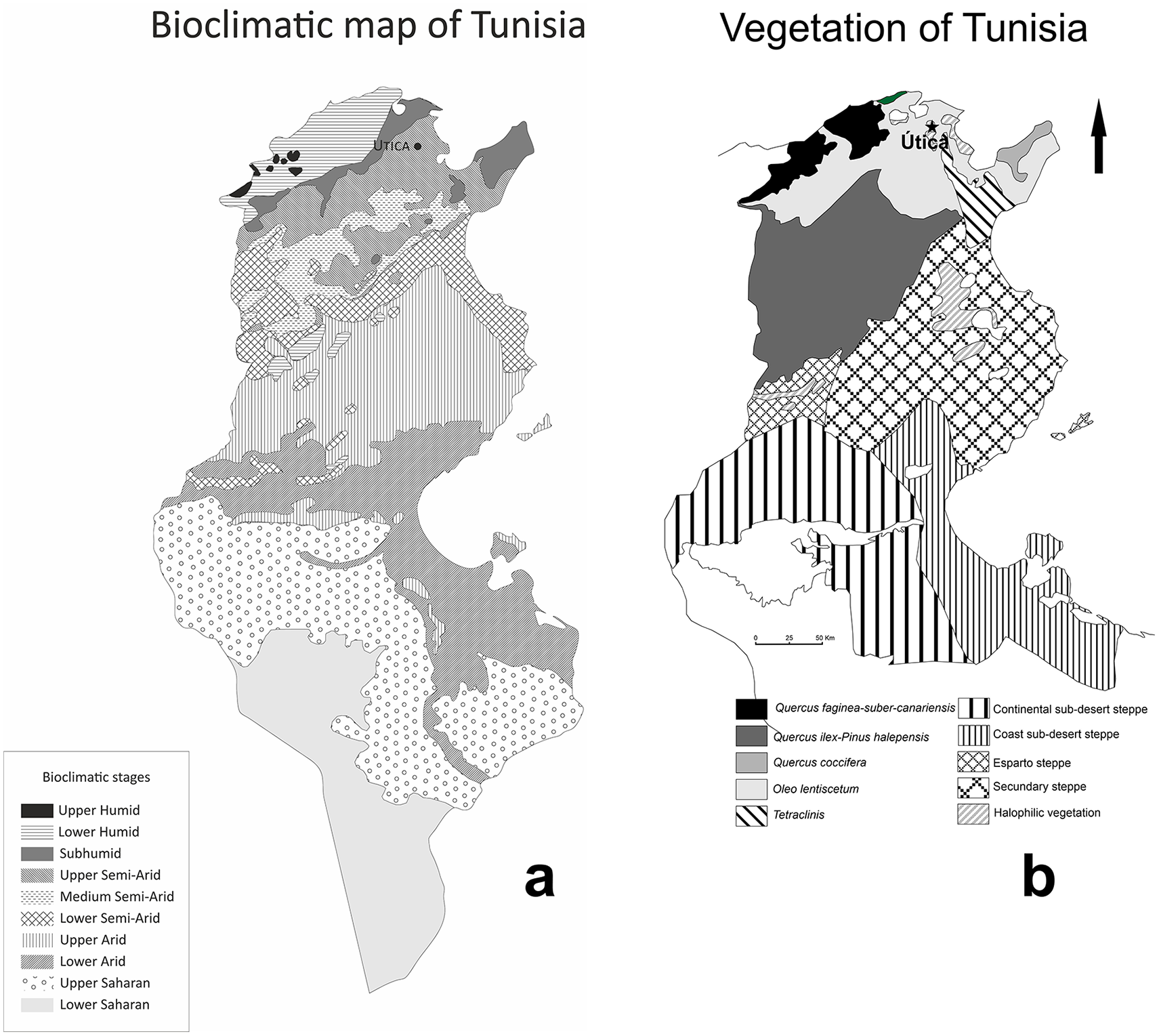
(a) Bioclimatic map of Tunisia (Institut National de Recherche Forestière [INRF], 1975), and (b) synthetic map of the main natural vegetation formations of Tunisia (redrawn from Gounot and Le Houerou, 1967).
This bioclimatic diversity lead to the existence of a large diversity of flora and a large amount of vegetation formations, both coastal and continental, which can be classified into three main areas (Figure 3b): Mediterranean Vegetation, Steppe, and Sub-Desertic and Desertic.
Mediterranean vegetation extends throughout all of the North of Tunisia and is distributed according to the dominant ombroclimate. In the Northern mountains, with precipitations between 800 and 1000 mm formations of Portuguese oak and cork-oak are dominant. In the central and Oriental areas whit precipitations between 600 and 800 mm climax plant formation belongs to the oleo-lentiscetum (Olea europaea and Pistacia lentiscus), in conjunction with carobs and chamaerops (Smaoui, 2015). In the Northeastern continental zone, with precipitations between 400 and 600 mm the dominant formation is the Holm Oak, which is mixed with the Aleppo pine below 1000 m altitude (Figure 3b). In the riparian formations of the bioclimatic humid and sub-humid levels there are poplars, ash, alnus, and elm. The riparian formations of the semiarid and arid levels are dominated by olianders and tamarisk.
The natural vegetation that would have been in the surrounding landscape of Utica would belong to the association of the Oleo-lentiscetum, aforementioned, though restricted to marginal areas, currently being occupied by agricultural fields, mainly of cereals such as wheat and barley.
Materials and methods
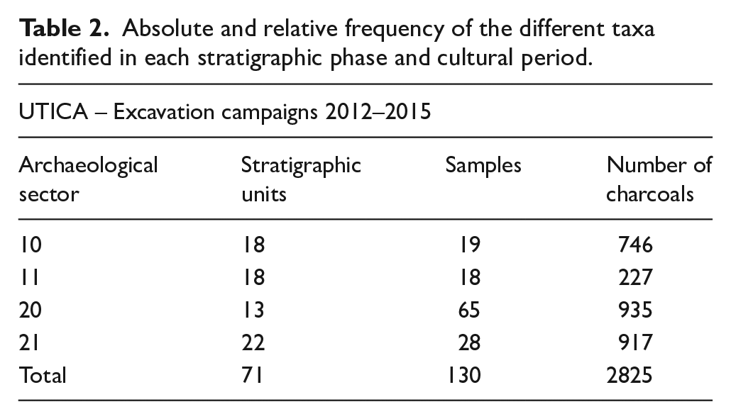
The conservation of the wood macro-remains at the archaeological site was produced by means of carbonization, as is common in archaeological contexts in the Western Mediterranean. A total of 3088 charcoal fragments belonging to sectors 10, 11, 20, and 21, from the excavation campaigns carried out between 2012 and 2015 in Utica have been analyzed (López Castro et al., 2014, 2015, 2016a, 2016b), though for the creation of the anthracological diagram (Figure 7) 2825 have been used (Table 1). The systematic recovery some 25 L of sediment per SU for flotation has allowed the analysis of 71 SUs. In some cases the amount was augmented, taking various samples per unit, so a total of 130 samples that conserved charcoal have been analyzed (Table 1).
Number of charcoals, samples, and SUs analyzed organized according the excavations sectors of Utica.

For the observation of the charcoals a reflected light microscopes (Olympus BX50) of the Paleoenvironment Laboratory of the University Institute of Research in Iberian Archeology of the University of Jaén (IUIAI) was used and a Scanning Electron Microscope (SEM) from the Center of Technical Scientific Instrumentation of the University of Jaén was used for microphotography (Figures 4 and 5).
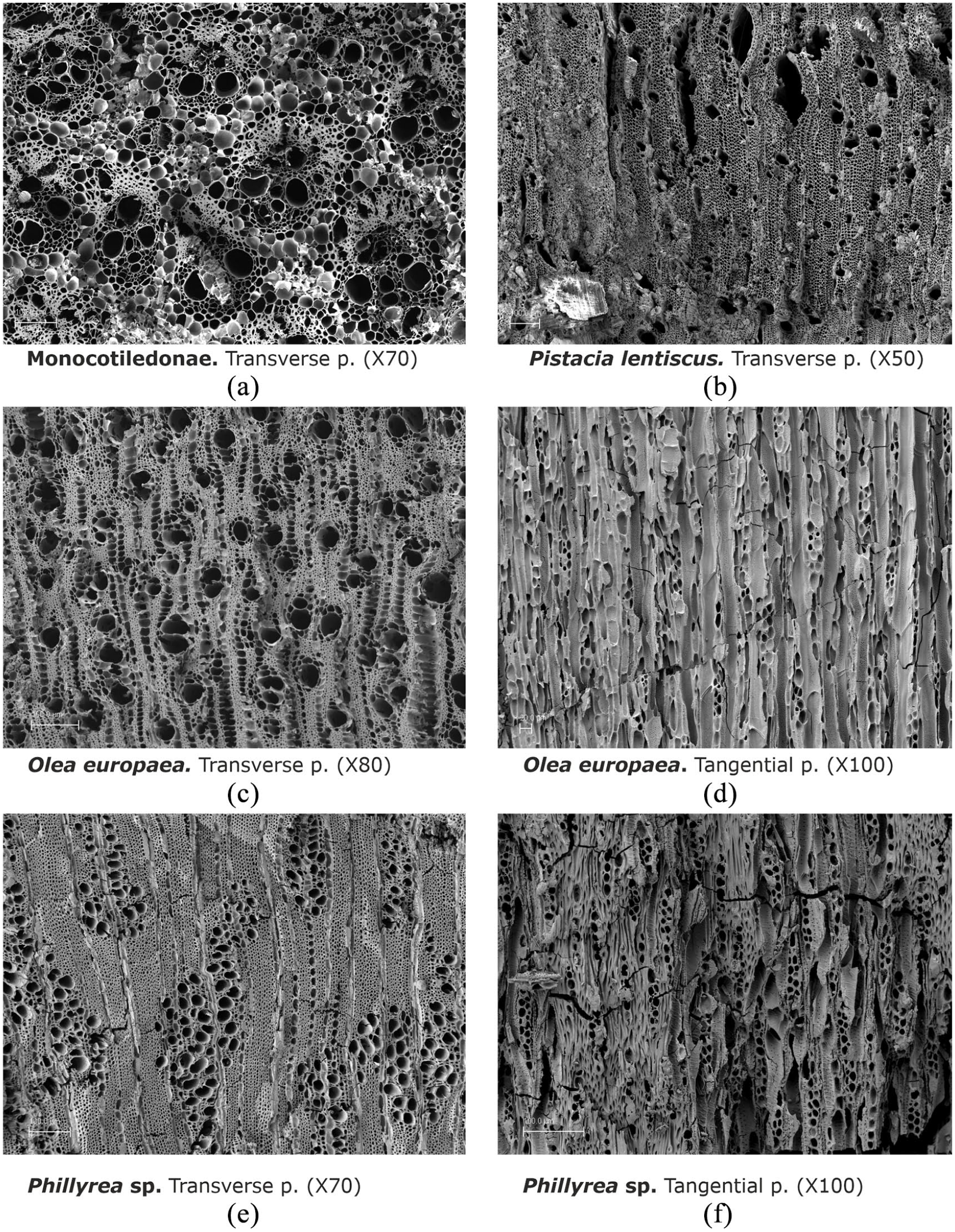
Microphotographs of archaeological charcoals obtained with SEM of the different taxa identified during the anthracological analysis of Utica: (a) Monocotyledonae. Transverse p. (×70), (b) Pistacia lentiscus. Transverse p. (×50), (c) Olea europaea. Transverse p. (×80), (d) Olea europaea. Tangential p. (×100), (e) Phillyrea sp. Transverse p. (×70), and (f) Phillyrea sp. Tangential p. (×100).
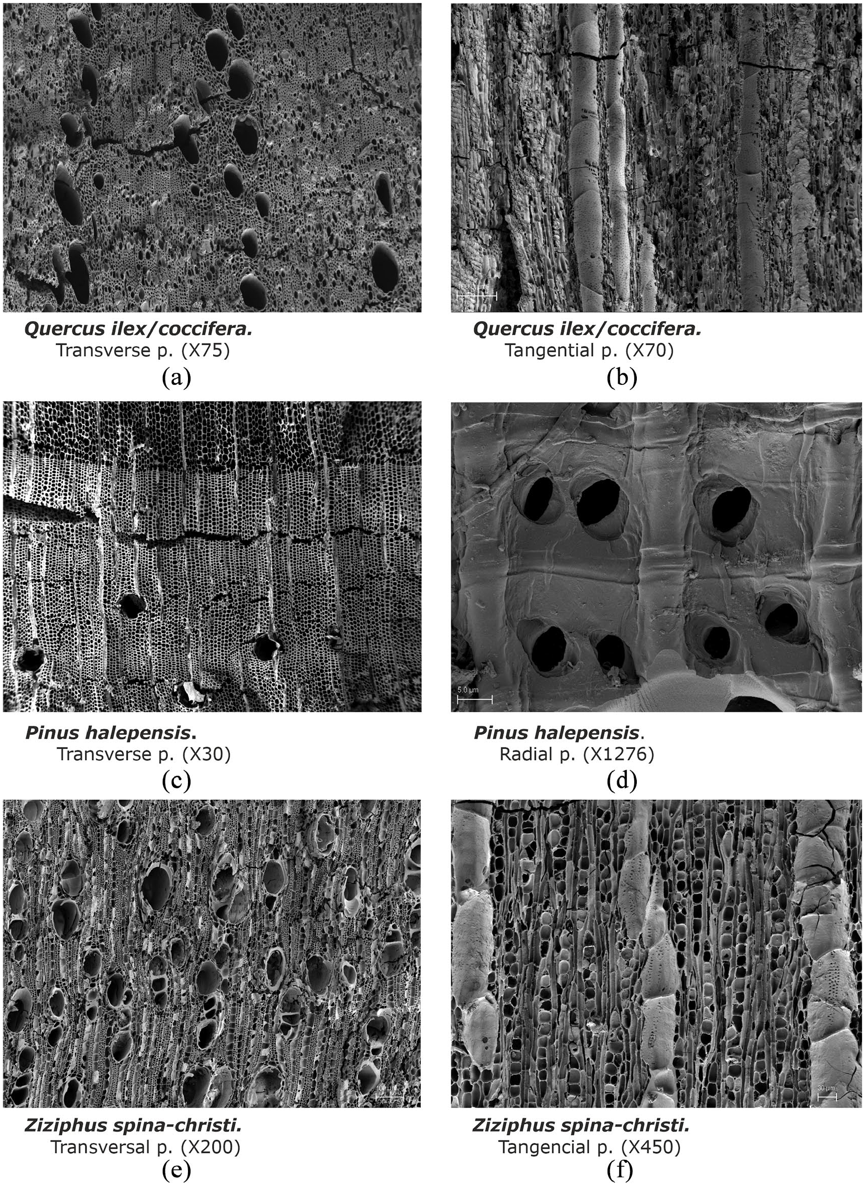
Microphotographs of archaeological charcoals obtained with SEM of the different taxa identified during the anthracological analysis of Utica: (a) Quercus ilex/coccifera. Transverse p. (×75), (b) Quercus ilex/coccifera. Tangential p. (×70), (c) Pinus halepensis. Transverse p. (×30), (d) Pinus halepensis. Radial p. (×1276), (e) Ziziphus spina-christi. Transversal p. (×200), and (f) Ziziphus spina-christi. Tangential p. (×450).
During the anthracological study the counting of the charcoal fragments was used as the quantitative base for the study, from which the paleoecological data has been inferred. The small size of the charcoals has allowed us to analyze almost all of the existing charcoals. The anthracological interpretation was carried out based on the floral spectrum or identified taxon list, while the graphs are expressed in relative frequencies.
The paleoecological study is based on the interpretation of the anthracological diagram (Figure 6), which include the charcoals that were found dispersed in the different archaeological stratum (2825 analyzed fragments). Table 2 details the taxa identified in each of the eight stratigraphic phases studied and their relative and absolute frequencies. Furthermore, we identify the frequency of the fragments that we have not been able to identify (Indeterminate) and the charcoal in a poor state of preservation (Knots, vitrifications, or calcareous concentrations) which are impossible to determine (Undetermined). The number of analyzed fragments and identified taxa are also included in the table, which allows us to carry out a quick evaluation of the floral variety of each analyzed phase. The relative frequencies that appear in these tables are used for the confection of the anthracological diagram (Figure 6). In the phases with few analyzed charcoal fragments (Phase IIB of the Early Phoenician, Punic Phase and Late Roman Phase), with 81, 77, and 46 fragments respectively, the relative frequencies are not established. Therefore, we have chosen not to represent them graphically, although the percentages of these taxa have been expressed in the corresponding columns of the diagram.
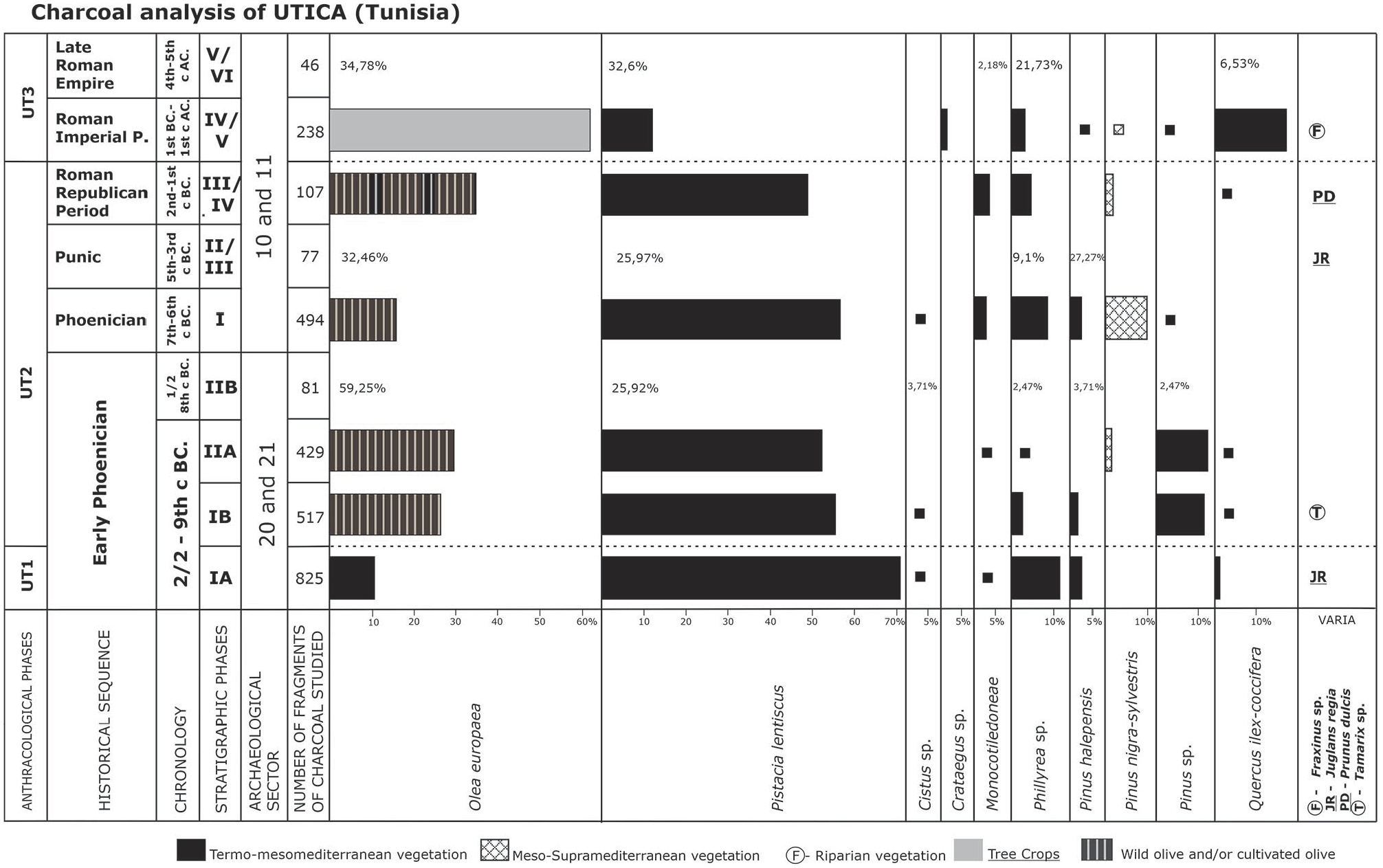
Anthracological diagram of Utica.
Absolute and relative frequency of the different taxa identified in each stratigraphic phase and cultural period.
The anthracological identification of the taxa has been carried out based on the comparison of the anatomy of the secondary xylem with various atlas of wood anatomy (Schweingruber, 1978, 1990; Vernet, 2001, etc.) and the reference collection of carbonized woods of the IUIAI.
The anatomical identification of charcoal usually reach the level of species, though in many it has reached only genus (Cistus, Crataegus, Fraxinus, Phillyrea, Pinus, Tamarix) or order (Monocotiledoneae) (Table 2; Figure 4). Nevertheless, some taxa can identify two species such as the case of the Quercus ilex-coccifera that integrates Quercus ilex and Quercus coccifera; and the Pinus nigra/sylvestris which can correspond to either Pinus nigra or Pinus sylvestris. In the case of the Olea europaea through anthracology it is not possible to differentiate between the wild and cultivated varieties.
The order of the taxa in the diagram (Figure 6) has been made by placing the two major taxa first: Olea europaea and Pistacia lentiscus; follows by the remaining taxa in alphabetical order. The colors or patterns indicate the vegetation belt of each taxon of the climatic vegetation (vegetation, which for its development, only depends on atmospheric conditions, mainly temperature and rainfall), also distinguishing cultivated trees and riverside ones. The values lower than 1% are represented by squares, while the column to the right includes the taxa that only appear occasionally.
Results
In the analysis of the samples a total of 14 taxa have been identified (Figures 6 and 7), which mainly, 12 taxa, belong to the natural vegetation developed in the area, though we do find two cultivated species: Juglans regia (walnut) and Prunus dulcis (almond). Among the natural vegetation we can differentiate the climatic vegetation, which is the natural vegetation that grows depending on the general climate conditions that exist in a place, mainly temperature and precipitation. We have been able to determine the following taxa: Olea europaea (olive), Pistacia lentiscus (lentisk), Cistus sp. (rockrose), Crataegus sp. (hawthorn), Phillyrea sp., Pinus halepensis (Aleppo pine), Pinus nigra/sylvestris, Pinus sp. (pine), Quercus ilex-coccifera, and Ziziphus spina Christi (Figures 4 and 5). The determined monocotyledoneae, since presenting a similar anatomy, have not been able to be assigned to this group. All these species could have been present in the surrounding landscape of the settlement.
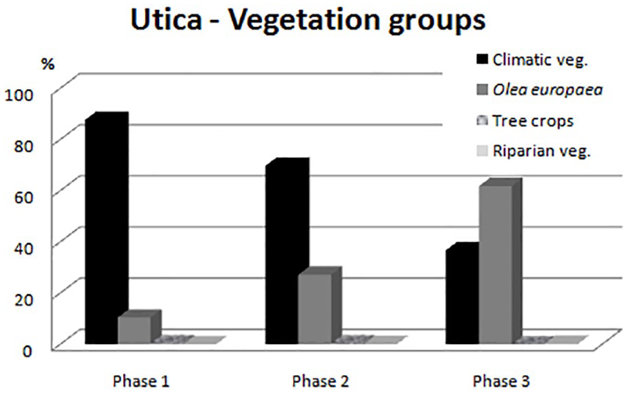
Evolution of the different vegetation groups and of the Olea Europaea during the three anthracological phases identified in Utica.
In the case of the Olea europaea we have opted to not include it in any of the vegetation groups since we could not differentiate between the wild and cultivated variety (Figure 4). Nonetheless, in the anthracological diagram (Figure 6), it is indicated as wild olive in phase 1, and in phase 3 as cultivated olive, while in phase 2 a mixture is made, when in doubt if it represents one or another variety for reasons we will discuss further on.
Among the riparian vegetation, or those that grow near water, we have identified Fraxinus sp. (ash) and Tamarix sp. (tamarisk).These last ones, in general, are developed near seasonal water courses or in areas with a certain degree of soils that contain salt. Nevertheless, the presence of both species among the charcoal samples that have been studied, is anecdotic, which indicates the inexistence of important water courses more or less near the site or that the wood of these riparian species was not recollected.
From a floral point of view we do not observe many changes, oscillating between 5 and 9 identified taxa. The three taxa that appear in all phases are: Olea europaea, Pistacia lentiscus and Phillyrea sp., which define the vegetation found in the landscape around Utica, formation characterized by shrubs and being thermophile. Nonetheless, the variations in the percentages of the two major taxa have allowed us to identify three anthracological phases. These phases are indicated in the first column of the diagram with the abbreviation of the site (UT) flowed by a number.
First anthracological phase UT1
This phase includes the stratigraphic phase IA from Sector 20, where an important amount of charcoal has been studied (Figure 6). It corresponds to the initial phase of the settlement.
In this phase there is a clear dominance of the Pistacia lentiscus, with a 71.7% of frequency. Phillyrea sp. with an 11.9% and Olea europaea with a 10.42% are the other two taxa with a significant representation. Of the remaining taxa only the Pinus halepensis presents a 2.4% frequency rate, while the remaining (Cistus sp., Monocotyledoneae, Quercus ilex/coccifera and Ziziphus) are 1% or lower.
The three main taxa define the natural vegetation, lentisk formation. This is a sclerophyll formation developed under warm thermo-mesomediterranean climatic parameters (Rivas-Martínez, 1987; Valle, 2004). Pistacia lentiscus requires less moisture than the Olea, being able to grow with and annual mean precipitation of 200mm, while the Olea develops optimally with an average annual rainfall exceeding 400 mm (Gammar, 2002; Spina and Pennisi, 1957). Therefore, the natural vegetation that the Phoenicians found when they arrived at Utica around the ninth century BC could have been lentiscar where the main species would be Pistacia lentiscus, Olea europaea, Phillyrea sp., some Cistus sp., Ziziphus and monocotyledoneae. This vegetation maintains an elevated cover of the ground and edaphic humidity. In some cases, this vegetal formation constitutes the first stage of degradation of the Quercus ilex formations, but when the ombrotype is semiarid (200–450 mm), which constitutes the climax formation in those territories, where forest formation is not possible.
The second anthracological phase UT2
This phase includes six stratigraphic phases, corresponding to the Initial Phoenician period documented in sectors 20 and 21, as well as the Phoenician-Punic and Roman Republican phases, all of which were documented in sectors 10 and 11. Chronologically they correspond to the time period between the last half of the ninth century BC and the first century AD, therefore representing and interval of approximately 800 years, in which the vegetation used as fuel by the inhabitants of Utica was fairly coherent and homogeneous in the six anthracological spectra that have been represented.
In this second anthracological phase the Pistacia lentiscus is still predominant, though its representation is lower than during Phase 1, with averages between 50 and 55%. This is followed by the Olea europaea, whose presence is higher than in the previous phase with averages between 16 and 35%. Finally the Phillyrea sp. sees its representation reduced with and average representation of 5%.
This important change in the percentages of the three main taxa could be interpreted in a triple sense: either due to climate change or due to anthropic action as a consequence of the introduction of the olive or to a change in wood collection strategy. We will this discuss this matter in the next section of the paper.
Next to these species there are Pinus halepensis and an important amount of Pinus sp., though not being able to identify the species, but it is very probable that they belong to the first one mentioned. These are developed in the surrounding and marginal areas. During the Phoenician period there is an important amount of Pinus nigra/silvestris (9.7%). It is significant that when these appear Pinus halepensis almost disappears, probably indicated the disappearance of the latter in the surroundings of Utica. The ecological requirements of these pine species, typically of mountainous areas and that live under supra-oromediterranean bioclimatic parameters, indicating that they would not come from the immediate surroundings of Utica, and that the presence of this wood in urban spaces must be related to constructive materials. They could have been brought to serve this purpose from the mountains of the North of Tunisia, were today there is no reference of their existence, or from other Mediterranean regions such as the Iberian Peninsula or Italy, with the possibility of Sardinia, which is only 2 days away by sail, a possible option taking into account the important Phoenician-Punic presence on the is and their relation to Utica, archaeologically evidenced since the earliest Phoenician period of the city, having located Sardinian ceramics (Jerbania, 2017; López Castro et al., 2016a).
The presence of Quercus ilex-coccifera is occasional, being scarce in the surrounding vegetation, and also taking into account that they are not part of Pistacia lentiscus formations, since its ecological requirements are more humid than the formation around Utica. It would possibly develop in the northern mountains.
In Phase 2, remains of cultivated trees appear, with Juglans regia walnut in the Punic period and Prunus dulcis in the Republican Roman. The scarcity of their presence could indicate, on one hand, that there were very few in the surroundings, or on the other that remains of pruning may have not been used as fuel. Though their presence is indicative that they probably developed and were cultivated in the area, either in fields or boundaries between them.
The third anthracological phase UT3
This phase includes of the Roman Imperial and Late Roman periods, archaeologically documented in sectors 10 and 11, with a chronology the first between the first century BC and first century AD and between fourth century and fifth century AD the second. However, its frequency is not very reliable because it has studied few charcoals and its representation has not been stabilized.
In this phase we observe an inversion of the percentages of the major taxa. In first place the Olea has a presence of 61%, followed by the Pistacia lentiscus, which is reduced to 12%. In this case we can identify, with almost complete certainty, the beginning of olive cultivation at a large scale, which also happens during this time period in other areas of the Western Mediterranean (Los Baños, Cástulo) (Rodríguez-Ariza and Montes, 2005). Olea europaea are now going to occupy areas that were previously occupied by Pistacia lentiscus formation, this vegetation being relegated to more or less marginal areas. Nevertheless, we observe a strong increase of Quercus ilex/coccifera, reaching 17%. This fact cannot be explained by an increment of its presences in the surrounding landscape, but rather to a change in the area of wood resource catchment. Since the natural vegetation, Pistacia lentiscus, are reduced to marginal areas, wood must be brought from other areas such as the mountains to the North or areas to the West of the site (Figure 3b), where the existing formation would consist mainly of Quercus ilex or Quercus coccifera trees formations, which explains the presence of some charcoals of Crataegus which grows in the undergrowth of these formations.
Evaluation and discussion
The anthracological diagram of Utica presents novel data regarding the vegetation of the surrounding landscape of the settlement and the management of wooden plants carried out by the inhabitants of Utica during the period under study. Furthermore, based on the results obtained, it raises new interpretations about the evolution of the wild olive and the beginning of its cultivation in Northern Africa. If we group the different taxa identified by the anthracoanalysis into vegetation groups we can identify three main groups:
– Natural climatic vegetation, represented by Pistacia lentiscus, Cistus sp., Crataegus sp., Monocotyledoneae, Pinus halepensis, Pinus nigra-sylvestris, Pinus sp., Quercus ilex/coccifera and Ziziphus.
– Waterside vegetation such as Fraxinus sp. and Tamarix sp.
– Tree crops, represented by Juglans regia and Prunus dulcis.
We must also add one more group, formed by Olea europaea. This is motivated by the anatomical impossibility of determining whether it is wild or cultivated and, therefore, could belong to the first or third groups, and also for its ecological and economic importance.
If we observe Figure 7, where the three groups belong in to the anthracological phases are compared, we can see how the vegetation that the Phoenicians found at their arrival at Utica was the natural vegetation, were riparian vegetation is inexistent and tree crops occasional. The presence of 10% of Olea is among the normal rate of wild olive in Pistacia lentiscus formation, documented in other sites throughout the Western Mediterranean, always at thermomediterranean and lower mesomediterranean belts (Carrión et al., 2010; Rodríguez-Ariza and Montes, 2005), identified at other sites such as Villaricos and Cerro de Montecristo, located in the southeast coast of the Iberian Peninsula (Rodríguez-Ariza, 2020).
During the second anthracological phase, we see an increase in Olea, up to 27%, with an inverse relation in the presence of climatic vegetation that descends from 87 to 70%. This natural increase of the Olea can be a consequence of, and has been interpreted as, climate change that tended to more humidity. We believe that this is not the case in anthracological phase 2. Nevertheless, the phenomenon of the expansion of the olea after a predominant phase of lentisks has been documented in the pollen study of Halk el Menjel, located in the Center of Tunisia, between pollen phase 3 and 4, with chronologies much older than those of Utica (Phase 3: 4946 ± 108 cal BP), 3972–3618 cal BC, which the authors associated to a humid episode between the Mid and Late-Holocene (Lebreton et al., 2015). Both here and in other areas of the Mediterranean this change is due to climate changes and is not related to human activity (Carrión et al., 2010; Di Rita and Magri, 2009; Jalut et al., 2009; Pantaléon-Cano et al., 2003; Yll et al. 1997).
Also has also been interpreted as a preferential selection of tree species, where the Pistacia lentiscus and olive wild were used as the main source of fuel by the inhabitants of Utica. This fact could occur since they are the most used species in most pyres of the sanctuary of the tophet of Carthage, dated between the sixth and fourth centuries BC. (Stuijts, 1991). However, the high number of charcoal studied, together with their recovery from different archaeological contexts and stratigraphic phases, we believe that it responds to the introduction of olive cultivation. This crop would still be incipient and not intensively developed.
Regarding the matter of the origin of olive oil production in Tunisia, it is still very complex matter. In fact, the pollen remains and seeds found within the sediment of the Punic canal in Carthage suggests that the olive production had a moderate importance in times of the Phoenicians until the fourth century BC (Bottema and van Zeiss, 1985; Van Zeist and Bottema, 1983; Van Zeist et al., 2001).
In anthracological phase 3, which corresponds to the Roman Imperial period, it seems to begin the systematic implantation of the olive fields, which contributes to the destruction of the natural surrounding vegetation. The transformation of the environment of Utica is done by breaking the “forest” and expanding the agricultural areas, leaving the natural vegetation reduced to stands and nearby mountainous areas. The decrease of the climatic vegetation to 36% seems to indicate that olives had occupied most of the flatlands around Utica, which seems to have not occurred in other areas of Tunisia. In Segermes, to the Northeast of Tunisia, the moderate presence of olive trees in the pollen spectrum of the Late-Holocene (Kolstrup, 1994) is interpreted as evidence for the Roman cultivation of olives though it would never become the economic mono-product of the area (Van Zeist et al., 2001).
In archaeobotanical studies of the sediments of the Roman port and the subsequent Byzantine occupation of Carthage, the cultivation of olive trees for consumption and export is poorly documented, while ancient texts attested the importance of the olive tree in the area’s economy (Van Zeist et al., 2001).
The Tripolitania pre-desertic area, paleoclimates research suggests that olive production began during the Roman-Libyan period, though Olea never surpassed 5% (Gilbertson et al., 1993, 1994, 2000). Despite this fact, the remains of Olea europaea have been found in contexts of open Roman-Libyan settlements and fortified villas in Libya (van der Veel et al., 1996).
Though the anthracological analysis has only identified two planted trees besides the olive tree, the presence of these charcoal give important notes regarding the introduction and development of arboriculture in the Western Mediterranean. As we have previously commented, Juglans regia has been documented in the Punic Phases. The appearance of charcoal of this species confirms its cultivation in the environment of Utica. Traditionally, the present of Juglans walnut pollen has been linked to the high dispersion rate it has, and the presence of Juglans walnut shells in Carthage was linked to imports from Europe or Turkey (Van Zeist et al., 2001).
The problem regarding the origin of the Juglans regia in Western Europe has been a highly debated matter. Many authors suggest that the Juglans regia essentially disappeared from Europe at the beginning of the Holocene (±11,700 BP), after the Last Glacier Maximum (Leslie and McGranahan, 1998), and was reintroduced by humans from Western Asia. The introduction of this species in the Aegean did not take place until the last half of the fourth millennium BP (Bottema, 2000). A second migration wave towards the southwest of Europe followed the Greek colonization between the eighth and fifth centuries BC (2800–2500 BP) (Sadori, 2013; Zohary and Hopf, 2000). Therefore, palynologists, after the study of Beug (1975) regarding the Dalmatian coast, established the “Juglans line,” which corresponds to the moment in which the walnut was introduced to the European Mediterranean, dated between the Iron Age and Romanization. The walnut tree became the signal that indicated the end of natural vegetation and the surging of a landscape extremely influenced by humans.
Recent studies based on the genetic diversity of 91 samples of euro-asiatic Juglans regia (Pollegioni et al., 2017) concluded that walnut trees existed in refuge areas of the Balkans and Western Europe during the Last Glacial period. The mixture between the Juglans germplasm of Anatolia and the Balkans began in the Early Bronze Age, while the Balkans and Western Europe mixed during the Roman Empire. Therefore, the presence of charcoal belonging to Juglans regia from the Punic phase of Utica can corroborate their introduction by the Greeks and, also, could indicate a new route of introduction of this species in the Southern Mediterranean and Northern Africa, linked to Phoenician colonization, which seems to be corroborated by the presence of a small Juglans curve since the second half of the sixth century BC in the Phoenician site of Villaricos in the Southeast of the Iberian Peninsula (Rodríguez-Ariza, 2020).
The presence of Prunus dulcis in the Roman Republican levels also seem to indicate the planting of this tree, probably having begun during an early phase, in correlation with the remains documented in the Punic levels of the port of Carthage, which in this case, contrary to what happens with Juglans regia, it is accepted that this tree could have been locally cultivated (Van Zeist et al., 2001). The expansion of the Prunus dulcis, as that of the Juglans regia, could be linked to the arrival of the Phoenicians, since in the South of the Iberian Peninsula we find remains at protoiberian levels such as at Los Baños of La Malahá (Rodríguez-Ariza, 2014), or at the Phoenician site of Cerro de Montectisto during the sixth century BC (Rodríguez-Ariza, 2020).
Footnotes
Funding
The author(s) disclosed receipt of the following financial support for the research, authorship, and/or publication of this article: Spanish Ministry of Economy and Competitiveness: research projects HAR2011-29880, HAR2014-53350-P and HAR2017-86334-R directed by J.L.L.C.