
Abstract
River rehabilitation has traditionally focused on hard-engineering projects, which often fail to address environmental protection concerns and social-ecological services in a larger territorial context. In particular, mountain rivers pose unique challenges due to their diverse hydrological and morphological conditions, which are often overlooked by traditional restoration methods. Consequently, water quality deteriorates and social-ecological imbalances arise. To address these challenges, we propose a holistic solution that integrates landscape infrastructure (LI), a soft-engineered biophysical structure and process. Our approach combines hydrological analysis, ecological sensitivity assessment, and ecological design solutions to develop an LI framework for the Xiaojiahe basin in the Chongqing Mountain range in southwest China. This framework emphasizes integration across the spatial scale of landscape networks and corridors. Our study reveals the existence of fragmented river systems and limited connectivity among green spaces in the research area. The adoption of a comprehensive Landscape Infrastructure (LI) framework facilitates the execution of culturally sensitive and practical design solutions for Mountain Urban River Restoration (MURR) at different levels. This approach reinstates the multifaceted environmental and socio-ecological benefits of the basin. We believe that our approach can be applied to other cases with similar contexts and challenges.
Keywords
Introduction
The expansion of urban areas and unrestricted use of river resources have led to increasing ecological issues for urban rivers (Guastella et al., 2019), including pollution, channelization, and loss of floodable areas. These actions have also made urban rivers more static and less dynamic. However, researchers worldwide have started implementing targeted ecological restoration measures to protect and restore river systems (Vorosmarty et al., 2010; Wang et al., 2018). In Europe, the Water Framework Directive (WFD) and Habitats Directive (92/43/EEC) have provided additional support for this growing awareness (Everard & Moggridge, 2012). Recently, developing countries have significantly invested in urban river restoration, and the implementation of such projects has gained momentum (Wyzga et al., 2018; Zingraff-Hamed et al., 2017).
Mountain rivers are distinct due to their diverse hydrological and morphological conditions, characterized by high slope and flow velocity. In recent decades, increasing attention has been given to the dynamics and biodiversity of mountain river restoration (Woellner et al., 2022). The study of ecological restoration methods in mountain rivers focuses on three main areas of interest: flow regime, sediment regime, and vegetation, including reach and catchment-wide aspects. However, most studies have focused on a single scale, primarily including catchment ecological status assessment and integrated ecological remediation methods at individual river sections (Hohensinner et al., 2021).
To enhance long-term sustainability, large-scale, holistic ecological restoration strategies that integrate river reaches with their respective basins are necessary (Wohl et al., 2005). However, past river restoration projects have tended to prioritize technical, engineering-driven approaches, and integrating social and cultural aspects into these approaches remains a challenge (Grêt-Regamey et al., 2016). This study aims to propose a comprehensive ecological restoration scheme that integrates various dimensions from a holistic perspective to enhance the long-term sustainability of restoration projects and fill these knowledge gaps.
In China, the “River Chief Governance” policy has been implemented to promote cross-catchment and cross-region governance, resulting in significant progress in river ecological restoration (Wang & Chen, 2020; Wang et al., 2021). However, the unique geography of mountain rivers, with their varying water fluctuations, water composition, and climatic elements, requires more extensive restoration to preserve the habitat dynamics and biodiversity of these systems and adapt them to climate change (Woellner et al., 2022). Additionally, China is currently undergoing urbanization in many impoverished cities situated in complex mountainous environments. These regions rely heavily on urban rivers due to the high costs associated with slope development and transportation, leading to increased river pollution. However, in recent years, the restoration of rivers in mountainous urban areas has gained attention, coinciding with increased investment in western development by the Chinese government. As such, large-scale and cross-scale connections are essential to ensuring the success of ecological restoration projects in mountain rivers.
The landscape serves as a comprehensive platform for assessing and understanding intentional landscape change and facilitating communication between science and practice (Prescott & Ninsalam, 2016). Landscape design modifies landscape patterns to provide ecosystem services that meet societal needs and respect societal values, bridging the gap between scientific knowledge of a landscape’s potential and ecological restoration (Nassauer & Opdam, 2008). Landscape infrastructure (LI) is an emerging concept of hybrid infrastructure that incorporates all infrastructures (e.g., green, blue, and gray) across the vast territory spectrum to build resilience and anticipate the uncertainty of climate change (Andersson et al., 2022). LI applies systems-based thinking to generate diverse ecosystem services and derive well-being for the benefit of humans and nature (Zhai et al., 2021). Research has been conducted on urban river restoration from the perspectives of blue-green infrastructure, gray infrastructure, and other approaches. For example, some studies have calculated the cost-effectiveness gap between gray and green infrastructure as components of urban drainage systems (Dong et al., 2017; Vojinovic et al., 2017). Ibrahim et al. (2020) proposed a park development plan based on green infrastructure to address local stormwater management issues. Guimarães et al. (2021), in their review of previous studies, emphasized the inclusion of both blue-green and gray infrastructure design considerations in river ecological restoration. Currently, most river restoration approaches lack comprehensive integration and tend to have scattered and singular objectives, failing to effectively coordinate the relationships between ecosystems, social needs, and economic benefits (Everard & Moggridge, 2012). The concept of landscape infrastructure emphasizes the integration of ecological restoration and urban development, breaking through land use limitations in urban river corridors and utilizing various potential spaces to achieve restoration goals collectively. The multifunctional nature of landscape infrastructure provides a practical approach for design implementation, while respecting the cultural and ecological characteristics of specific regions, making it possible to create resilient urban river spaces with a sense of place.
This study adopts the concept of LI as a source of inspiration and hybridity in design solutions for the holistic restoration of cross-scale connections across river sections, using the Xiaojia River in Chongqing, China, as an example. We develop an applicable and feasible LI framework that considers the needs of urban development and the health of river ecosystems to realize the full spectrum of river ecological services and values. Specifically, this study aims (1) to provide theoretical guidance and analyze the correlation of the MURR process with a spatial framework of LI; (2) to conduct cross-scale hydrological analysis and ecological assessments at both the river reach scale and in the catchment context; and (3) to develop pragmatic approaches that support the practical application of techniques and tools for MURR projects in the future.
Methods
Study Area
To investigate the potential of using landscape infrastructure for restoring urban river ecosystems, this study focuses on small urban rivers that are most affected by urbanization in built-up areas. The study area is situated in a renowned river city, but its secondary urban rivers in the main urban area suffer from severe ecological pollution. Since 2008, relevant government departments have issued numerous policy documents to assist in the comprehensive management of these primary and secondary rivers. Given the difficulty in acquiring data and the research scale, we selected the Xiaojiahe River, a significant secondary urban river in the main urban area, as the study subject.
The study area for this research is the Xiaojia River basin, located in the mountainous city of Chongqing in southwest China. Chongqing has a subtropical temperate monsoon climate, with an average annual temperature of 17.5°C and an average annual rainfall of 1085.3 mm. The flood season is mainly concentrated between April and October. The Xiaojia River is a first-class tributary on the north bank of the Yangtze River, covering an area of 53.68 km2 and dominated by shallow hilly terrain ranging from 250-370 m above sea level. Due to the hilly topography, the study area is susceptible to heavy rainfall during the flood season. The dynamic nature of the Yangtze River causes water levels in the estuaries of the basin to fluctuate constantly, with a difference of approximately 11 m between the highest and lowest water levels yearly. With increasing urbanization, urban built-up areas now account for 55.83% of the entire basin, leading to severe degradation of the Xiaojia River basin ecosystem due to human activities (Figure 1). Displays the location of Xiaojia River basin within Chongqing, a typical mountain city situated in the southeastern part of the Sichuan Basin. The city is characterized by its unique topography, built on mountains and surrounded by water, including two main rivers, the Yangtze and Jialing, and over 20 major secondary rivers of various sizes. The Xiaojia River, located on the left bank of the Yangtze River, is one of these secondary rivers and is classified as a first-class tributary.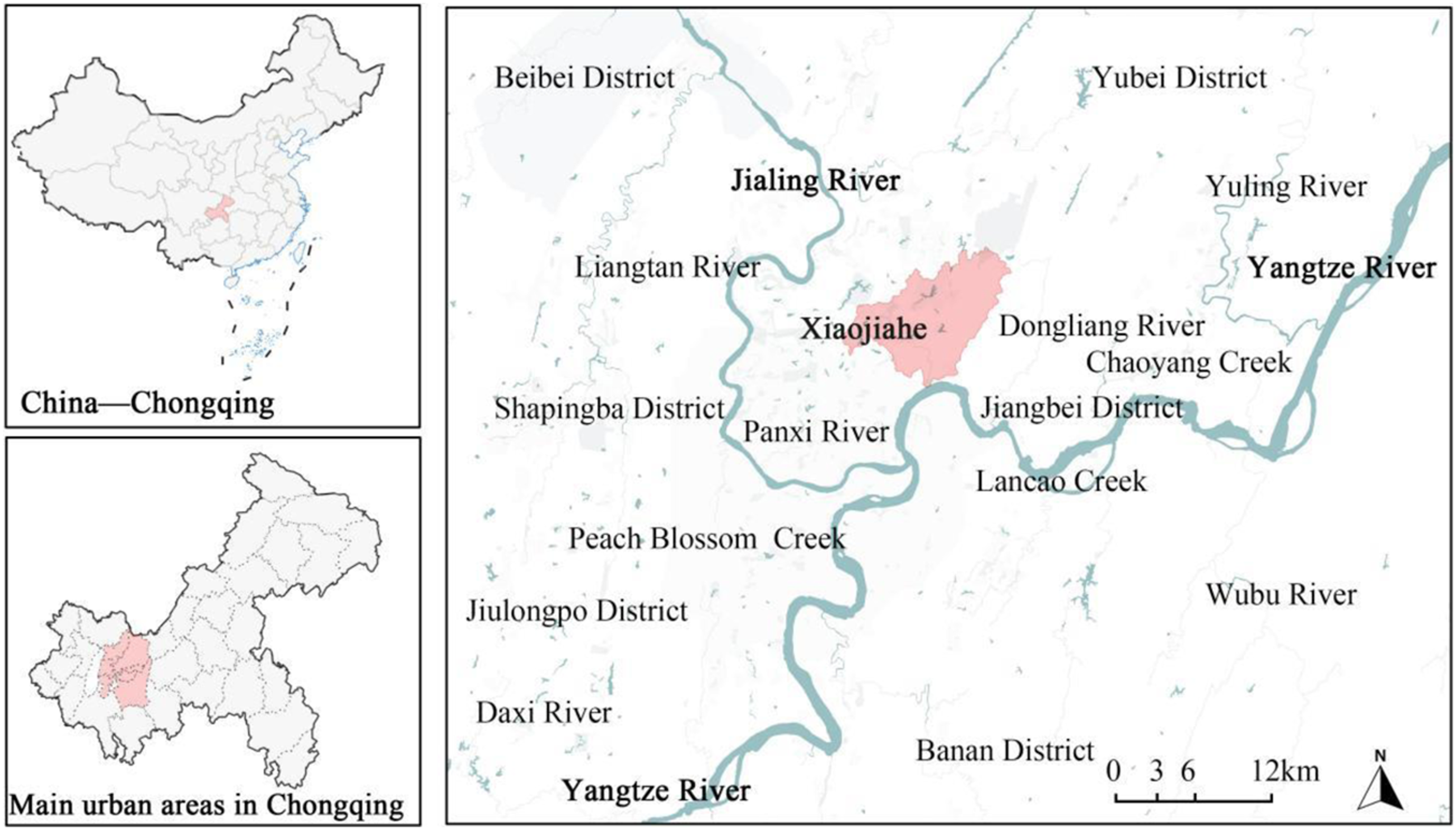
Theoretical Framework
There is a growing recognition of the need to shift river restoration approaches from engineered techniques and tools towards spatial analysis methods focused on understanding ecological spatial processes (Espinosa et al., 2016). However, implementing this shift in practice is challenging due to a lack of scientifically robust and pragmatic strategies and tools (Everard & Moggridge, 2012). To better serve the sustainable development goal of mountain urban river restoration (MURR), we embraced hybridity and systems-based thinking and proposed a twofold cross-scale spatial strategy. Firstly, at the basin scale, our objectives include compositing the network of ecological safety, stormwater purification, and storage. Secondly, at the reach scale, our objectives include implementing corridors of ecological restoration, landscape system construction, and cultural characteristic expression. The range of ecological processes involved in river ecosystems and the scope of hydrological processes often overlap at the basin scale. Therefore, it is essential to recognize hydrological processes when conducting ecological restoration for rivers (Wang, Yi & Fang, et al., 1999). Mountain rivers present even greater challenges due to their unique geographical characteristics and ecological sensitivity. Therefore, it is imperative to develop appropriate tools to identify and protect sensitive areas of the ecosystem during the restoration process, to avoid larger-scale damage (Shi et al., 2018; Zhang & Zhang, 2018). Tool development is therefore a prime concern for spatial planning, and with sensitive planning, the negative impacts of urban development on hydrological processes can be minimized (Whitford et al., 2001). In this research, to evaluate the effectiveness of restoration, we developed innovative metrics. Hydrological pathway analysis and ecological sensitivity assessment were chosen for the MURR, combined with our research objectives and LI spatial patterns, we proposed a multiscale and multipurpose framework for the MURR contextualized in a catchment context (Figure 2). Illustrates the LI framework for MURR, which consists of three main steps. Firstly, the correlation between the concept of LI and the objective of MURR is analyzed. Secondly, spatial patterns and objectives of LI are combined to develop LI-based strategies for MURR. Lastly, basin scale networks and reach scale corridors are deployed based on hydrological process analysis and ecological sensitivity assessment.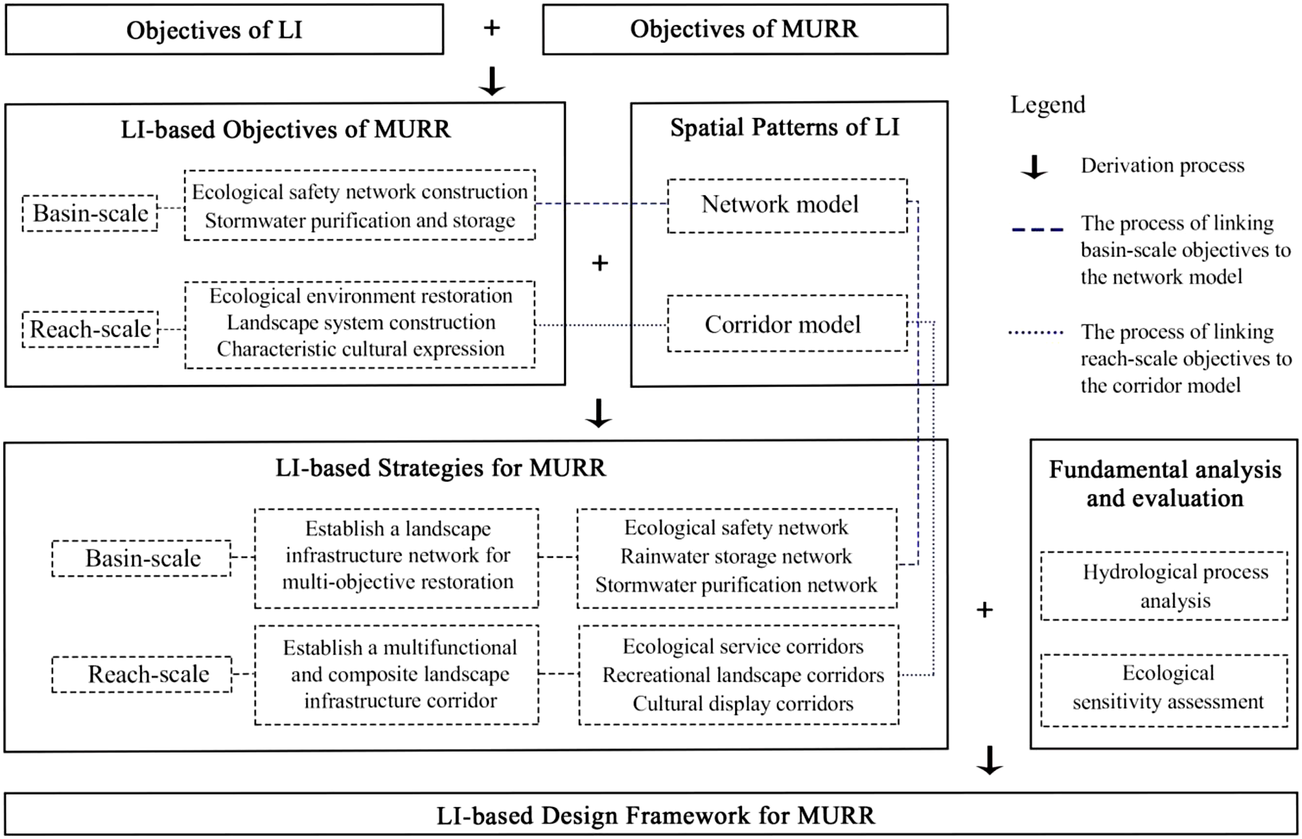
Hydrological Analysis
This section focuses on analyzing the hydrological processes in the Xiaojia River basin in terms of stormwater discharge routes. Comparing the catchment system in its natural state with the existing conditions will help identify obstacles within the current river systems. By simulating stormwater runoff in the basin, the “matrix-corridor-patch” structures associated with hydrological processes can be identified, and their relationship with landscape patterns can be reestablished. This exercise will prepare for resetting local river landscape patterns, ecological safety matrices, stormwater regulation, and storage networks according to their hydrological pathways.
To accomplish this, we first employ the Hydrology tool in ArcGIS to process the raw digital elevation model (DEM) data, including elevation, aspect, slope, and direction, to locate low-lying lands. We then use the Flow Direction Tool to obtain the flow direction. Since the size of the converging flow is proportional to the formation of surface runoff, we import the water flow direction data and utilize the fill accumulation tool to obtain the site confluence accumulation data to analyze the surface runoff. Finally, we conduct river network simulation with the Flow Length, Raster Calculator, and Stream Order tools.
This hydrological analysis will provide a better understanding of the basin’s stormwater discharge routes and allow us to identify potential areas for restoration. By integrating this analysis with the LI framework, we can develop effective strategies for restoring the river ecosystem and promoting the well-being of both humans and nature.
Ecological sensitivity assessment
Ian McHarg’s “layer-cake” theory is utilized to classify the suitability of a site by superimposing and weighting natural, biophysical, and built elements (Steiner, 2017). The theory emphasizes the need to protect ecological processes such as hydrology, geology, soil, flora, and fauna. The spatial patterns of the landscape formed by these ecological processes are used as the boundary to limit urban development and avoid construction in areas with high ecological sensitivity, ensuring the stability of the ecosystem and promoting sustainable urban development (Liu et al., 2009; Wu et al., 2017).
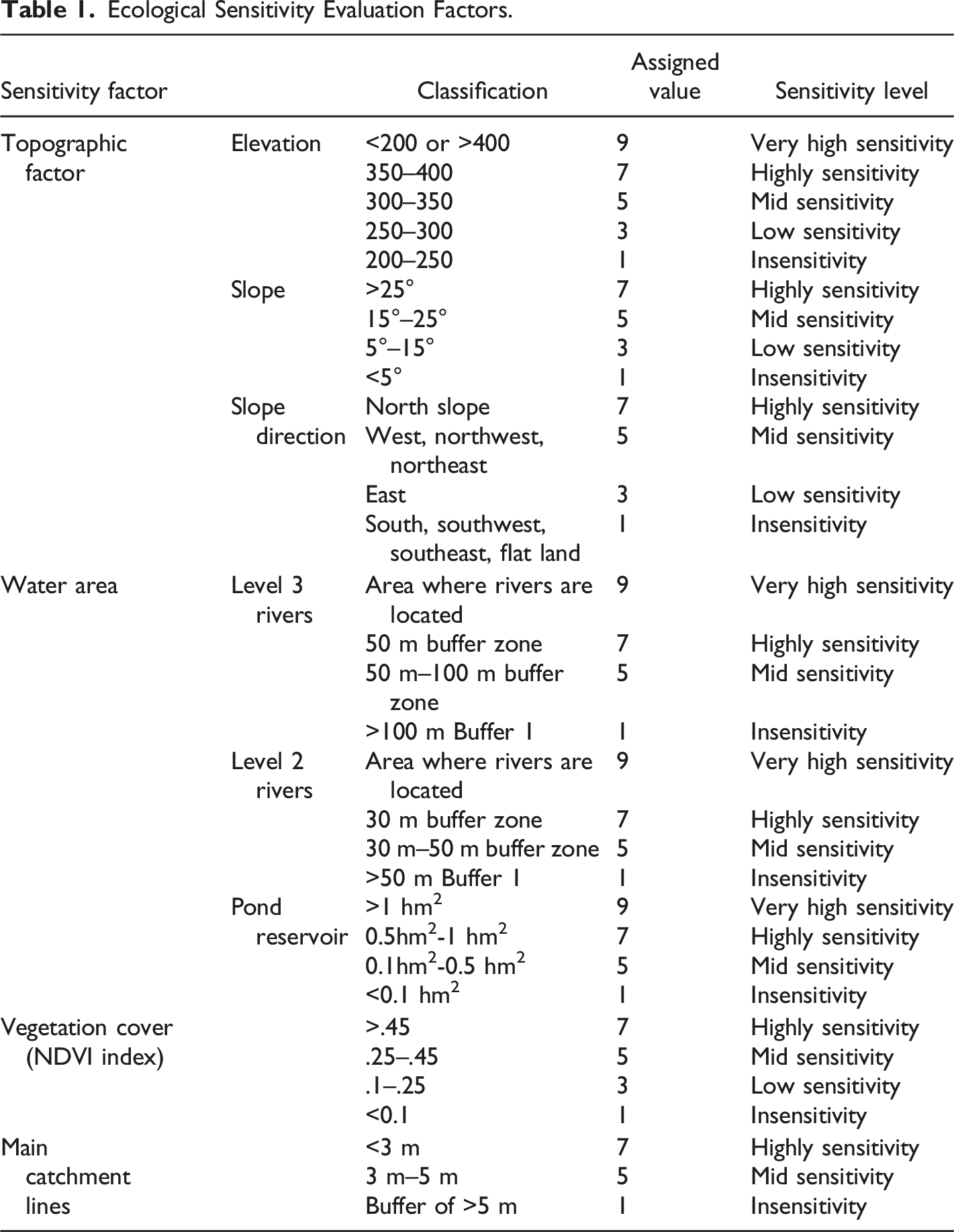
For this study, we selected ecological sensitivity factors closely related to the hydrological process in the Xiaojia River catchment for superposition analysis. The results were used as the basis for defining the site zoning. By combining expert scoring methods, we established an evaluation matrix, and then employed the hierarchical analysis method to evaluate the factors affecting river spaces. Finally, by employing the superposition analysis of GIS, we determined the sensitivity level for establishing the river ecological safety patterns.
Selection of Ecological Sensitivity Factors and Their Evaluation
Ecological Sensitivity Evaluation Factors.
Determining Indicator Weights the Ecological Sensitivity Evaluation
Weight Comparison Matrix.

The numbers in the table indicate the following meanings:
1: two compared, equally important;
3: compared to two, one is slightly more important than the other;
5: compared to two, one is significantly more important than the other;
7: compared to two, one is more strongly important than the other;
9: compared to two, one is more extremely important than the other;
2, 4, 6, 8: median value of adjacent judgments between two.
Inverse: if the importance ratio of factor i to factor j is a ij , then the importance ratio of factor j to factor i is the inverse a ji = 1/ a ij .
Calculation of the matrix weights (Al-Harbi, 2001):
(i) Calculate the product of elements in each row of the judgment matrix M
i
(u is the matrix of two comparisons, n is the order of the matrix, and i and j are two elements).
(ii) Calculate the nth root of Mi, and the result is noted as:
(iii) The square root vector W
i=
(
Then, the nth root of A=(a1, a2..., an).
(iv) One-time test.
a. Calculate the maximum characteristic root λ
max
, ((UA)
i
denotes the i-th element of vector U) of the judgment matrix.
b. Calculate the judgment matrix deviation consistency index C.I.
c. Calculate the random consistency ratio C.R. of the judgment matrix.
The judgment matrix is considered consistent when C.R. < .01, indicating that the weight assignment is reasonable; otherwise, the judgment matrix needs to be adjusted until satisfactory consistency is achieved. This validation method is used to assess the pairwise comparison matrices constructed based on expert ratings, aiming to identify any logical issues and ensure the reliability of the results. Finally, the consistency check of the matrix is performed: if the consistency ratio CR value is between 0 and .1 (CR = CI/RI), the matrix is correct; if it is out of range, the value is readjusted. The maximum eigenvalue λmax of the matrix was calculated from the discriminant matrix, and the consistency index CI = (λmax-n)/(n-1). Then, the required RI values are selected for the consistency test against the average randomness consistency index.
Integrated Evaluation and Analysis of Ecological Sensitivity
Site integrated ecological sensitivity was obtained by using a weighted sum model and a spatial superposition analysis of the single factor in ArcGIS.
Results
Hydrological Process Analysis
When calculating the water flow direction, the presence of low-lying areas can lead to unreasonable or incorrect flow direction data, which can affect the extraction of the river network. To address this issue, it is necessary to fill the original digital elevation model (DEM) data to obtain a DEM map without low-lying areas.
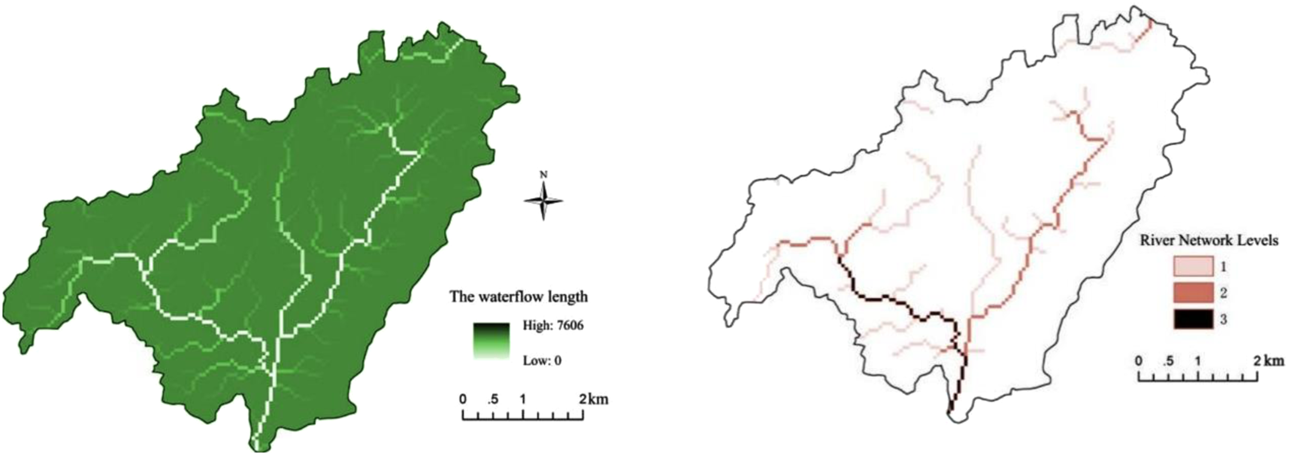
In ArcGIS, we identified improper low-lying lands based on the direction of the runoff and calculated their depths. We also set the fill threshold by referring to the site topography to obtain depression-free DEM data. This data was then inputted into the Flow Direction Tool to obtain the flow direction. We conducted statistical base confluence accumulation to analyze surface runoff (Figure 3). The flow length was calculated as the number of grids at the longest distance along the flow direction to the upstream grid. In this river network simulation, the river network grid calculation was vectorized and divided into three levels (Figure 4). Displays two maps of the study area. The left map depicts a digital elevation model (DEM) of the site, excluding low-lying areas. The depth of filling, ranging from a maximum of 514 to a minimum of 155, is indicated by the fill extract. The right map illustrates the extraction of flow direction, with rectangles colored in grayscale 1 to 128 indicating the flow direction. Presents two maps of the study area. The left map shows the water flow length, which is calculated by projecting the maximum ground distance between a point on the ground and the end of its flow direction onto the horizontal plane. The maximum length of the site flow is found to be 7606. The right map demonstrates the grading of the river network, where river types are identified based on the number of rivers, and the river network is divided into three levels.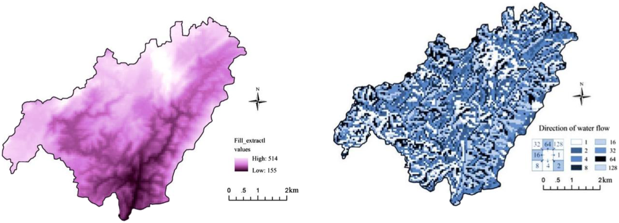
We identified three major issues in the river landscape patterns of the Xiaojia River basin by comparing the existing situation of the watercourse and green spaces with the catchment system. Firstly, there are discontinuous river systems, with many Level 1 reaches invaded and occupied by built elements and streets, and some Level 2 reaches replaced by culverts and piped drainage systems. This has interrupted the original water confluence mechanism, resulting in the rapid discharge of stormwater through underground drainage systems without collection and utilization, leading to a waste of rainwater resources and surface water pollution. It has also disrupted the stormwater transfer mechanism, leading to abnormal rain, flood regulation, and storage in the river basin, ultimately bringing severe flood threats to low-lying terrains.
Secondly, there is an insufficient width of river corridors. Studies show that a river corridor greater than a certain width can effectively control soil loss, improve habitat diversity, and filter pollutants effectively. However, parts of the Xiaojia River have a narrow width, which hinders the ecosystem functions of the river.
Finally, there is a lack of connection between green patches in the catchment, which limits the ecosystem services they can provide. Only by connecting separated patches to the river landscape pattern network in the catchment can we maximize their overall ecological benefits.
Ecological Sensitivity Assessment
In Section 2.4.1, we conducted an ecological sensitivity assessment of the Xiaojia River basin. To perform this assessment, we gridded the data on various factors in GIS and reclassified them based on the ecological sensitivity genus value. This allowed us to create an ecological sensitivity assessment diagram for each individual factor, as shown in Figure 5. Shows the outcomes of a single factor analysis of ecological sensitivity evaluation in the Xiaojia River catchment. To generate these results, we rasterized data from eight factors, namely elevation, slope, slope aspect, third-level river network, second-level river network, ponds and reservoirs, vegetation, and catchment lines, based on the ecological sensitivity evaluation factor table.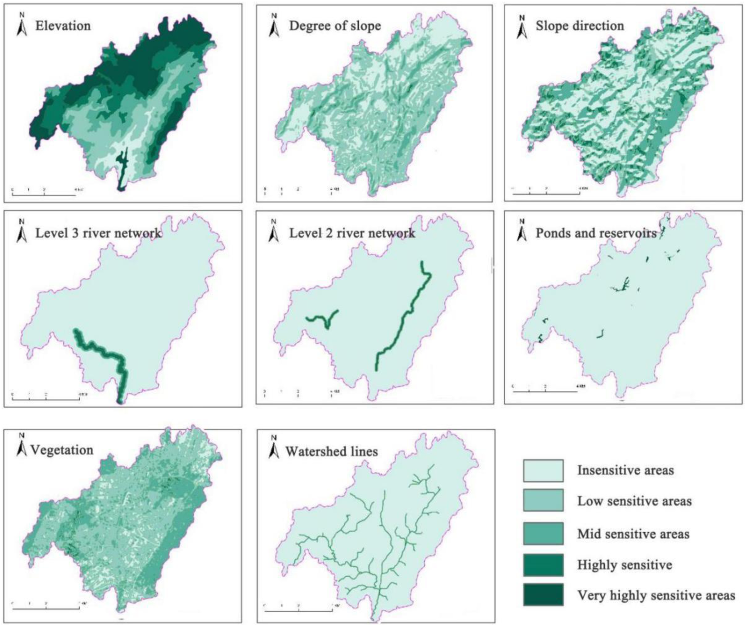
Mean Random Consistency Index R. I.

Using the final evaluation index weights of .083, .051, .037, .259, .178, .155, .099, and .137, we were able to prioritize areas for restoration and establish effective strategies for promoting sustainable urban development in the Xiaojia River catchment.
Comprehensive ecological Sensitivity Evaluation.

Deployment of LI-based Design Strategies for MURR
In recent years, there has been a significant increase in the implementation of urban river restoration projects, as the benefits of restored ecosystems on both social and ecological levels have become more widely recognized (Everard & Moggridge, 2012). To effectively restore river basins and achieve river continuity, new environmental configurations need to be considered (Thomas, 2022). In order to incorporate both environmental and sociocultural aspects of urban river restoration into the design process for the MURR project, we are exploring the use of LI strategies. LI involves the strategic design of natural and semi-natural features, creating networks and corridors to provide a wide range of ecosystem services at multiple scales and for multiple purposes.
LI Network at the Basin Scale
Ecological Safety Network
To establish an ecological safety network, it is necessary to overlay vertical and horizontal patterns to develop a river ecological safety pattern that consists of an “ecological matrix and interconnected network.”
We identified three ecological sensitivity zoning layouts for the Xiaojia River catchment: ecological protection, ecological control, and ecological guidance (Figure 5). The ecological protection zones have extremely high and high ecological sensitivity and are primarily located in the buffer areas of rivers, ponds, and reservoirs, as well as on the hills of Tongluo Mountain. These areas are sensitive and fragile and will be protected as ecological reserves, with strict control of urban development.
The intermediate eco-sensitivity areas are ecological control zones. While allowing low-intensity development in these areas, building density and environmental impacts should be under intensive monitoring to minimize the negative impact on the ecosystem.
The insensitive and low sensitivity areas are ecological guidance zones suitable for future urban development. However, studies on space capacity and ecological tolerance need to be carried out to avoid pollution and environmental damage caused by possible overdevelopment.
(1) Vertical pattern
Topography plays a critical role in shaping the unique functional structure of urban rivers in mountainous regions (Liu et al., 2011). It primarily involves vertical changes in slope, elevation, and slope aspect, which make up the vertical pattern of terrain. The protection scope of the vertical pattern is determined based on ecological sensitivity assessments of river systems, buffer zones, ponds and reservoirs, as well as hills in the Tongluo Mountain areas of the Xiaojia River Basin (Figure 6). These areas should mainly be subjected to ecological protection, with any landscape construction carried out only in compliance with natural ecological processes of the river and without causing any damage to it. Urban development, however, must be strictly prohibited. Illustrates the vertical protection pattern, which was developed by overlaying the results of ecological sensitivity analysis, including elevation, degree of slope, slope direction, level 3 river network, level 2 river network, pond and reservoir, vegetation, and catchment lines. The resulting pattern was divided into three zones: ecological protection zones, ecological control zones, and ecological guidance zones.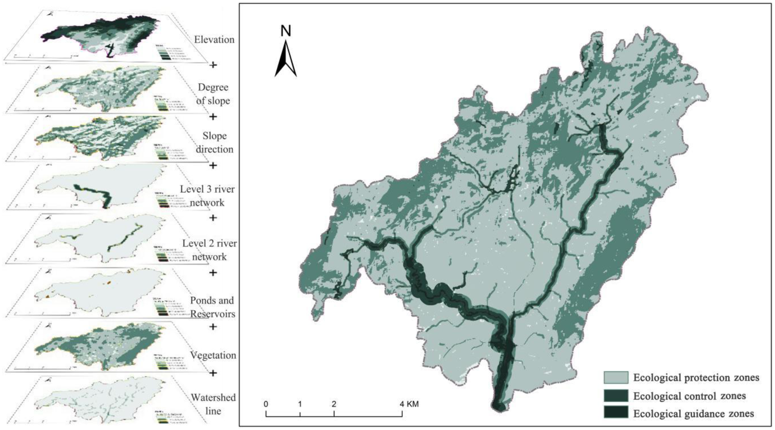
(2) Horizontal pattern
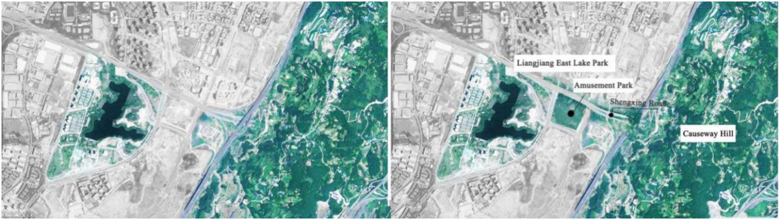
Based on the hydrological process analysis results presented in Section 2, we have developed adaptive strategies for improving the horizontal pattern of rivers in the Xiaojiahe basin, as follows: (i) Dredging key river corridors and restoring their continuity, focusing primarily on level 2 and 3 reaches. By removing obstacles from the rivers and incorporating linear greenways, street green spaces, and pocket parks, we aim to enhance connectivity between reaches at all levels. (ii) Expanding the width of the river corridors by linking protective green belts and other linear green spaces along rivers with widths less than 30 m to form a networked river buffer belt, thereby improving the delivery of ecosystem services. (iii) Enhancing the connection between green patches by reconnecting isolated vegetation patches with the river green network. To maximize ecosystem services, we are linking roads with surrounding green spaces, parks, and open spaces to construct new stormwater corridors along existing drainage pathways (Figure 7). Depicts the transformation of fragmented patch connections in Liangjiang East Lake Park. The park is currently isolated from the surrounding matrix, but we aim to embed it into the river basin by using Shengxing Avenue, a green road, to connect it with Tongluo Mountain.
The horizontal patterns are combined with the vertical patterns to create a river ecological security pattern with an “ecological matrix and connected network” (Figure 8). This pattern serves as the foundation for river ecological safety protection and forms the basic framework for the open space system. Illustrates the current status of river landscape patterns (left). The existing river system has been significantly impacted by urbanization, resulting in disrupted water catchment mechanisms, inadequate river corridor widths, culvert replacements in some sections, and fragmented green spaces. The proposed ecological safety networks (right) are formed by superimposing the horizontal patterns with the vertical patterns.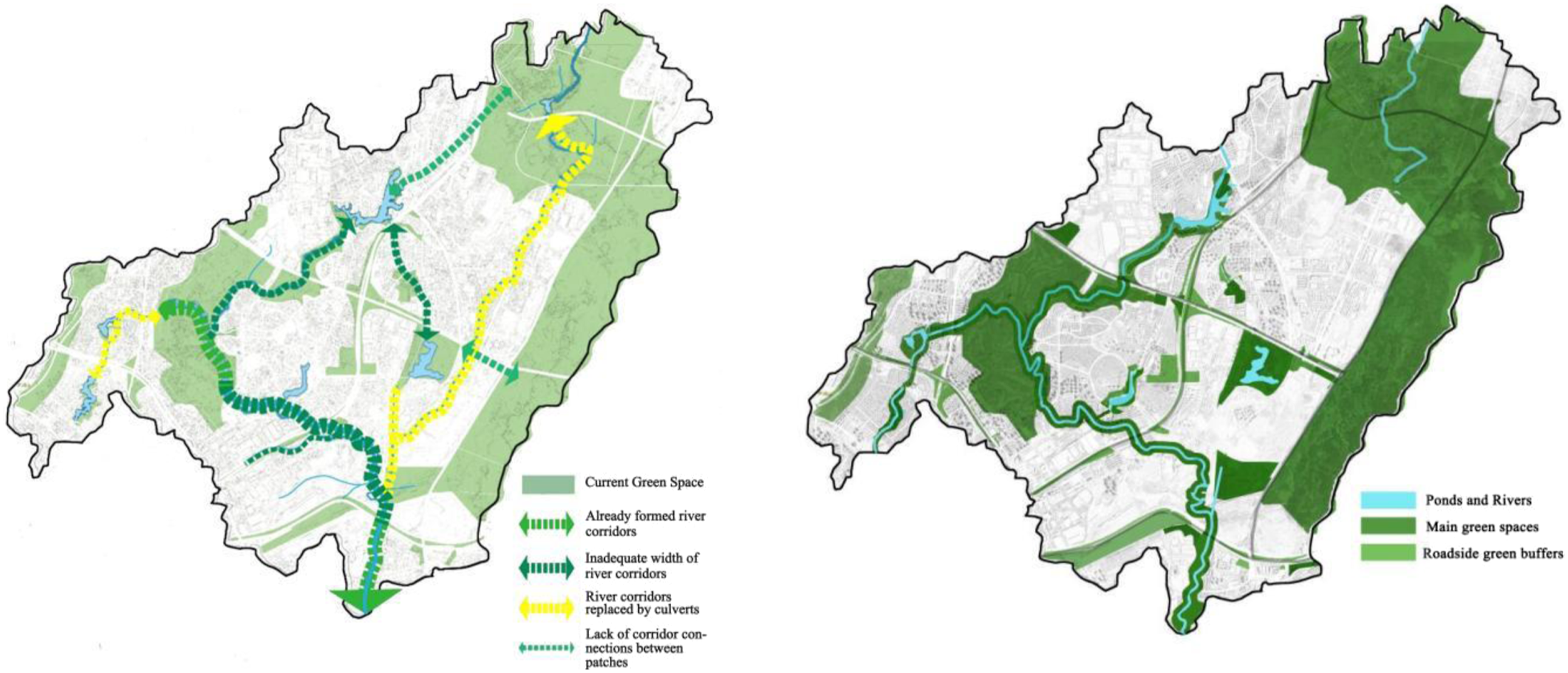
Stormwater Storage Network
(1) Decentralized stormwater management
In our study, we divided the Xiaojia River basin into 13 stormwater catchment units (Figure 9) using basin delineation. These units are interconnected, and each unit forms part of an independent stormwater collection, recycling, and utilization system. The objective is to safeguard the river in the basin and ensure primary stormwater purification and storage. Illustrates the decentralization of rainwater management units. The basin catchment area was delineated using the Shaw River catchment unit as the boundary. Then, by combining the water system with the road boundaries, the Xiaojia River basin was divided into 13 subcatchment units.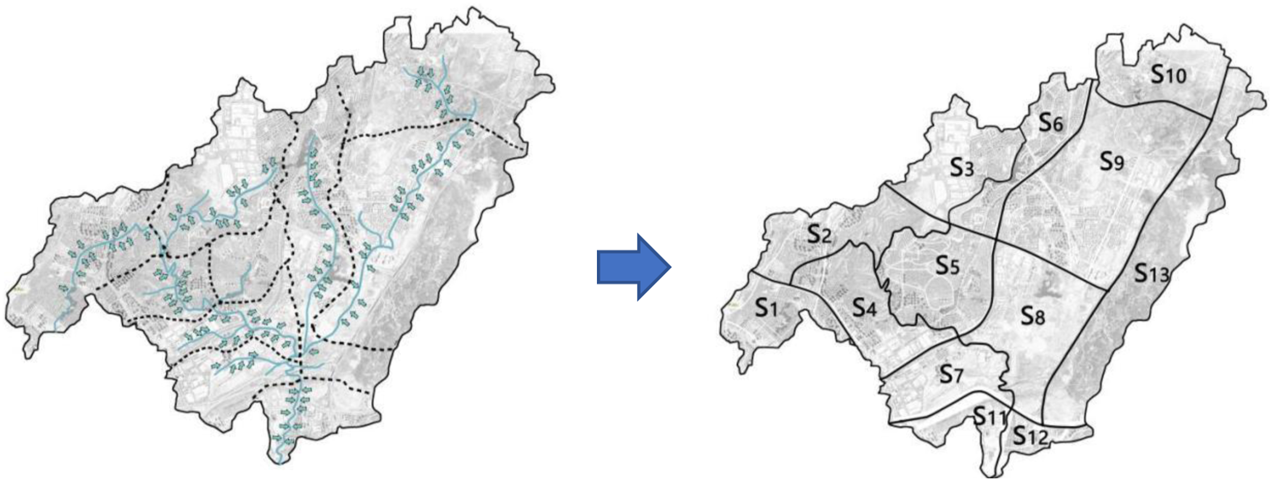
(2) Landscape Stormwater Pathways
The hydrological process analysis results presented in Section 2 revealed that rapid urbanization had disrupted the original water transfer mechanism in the Xiaojia River basin. Therefore, we analyzed the terrain and stormwater flow direction in the basin and proposed the connection of roads with surrounding green spaces and parks to create eight landscape stormwater corridors (Figure 10). These corridors offer several advantages, including reducing the flow rate of stormwater, collecting and storing stormwater nearby, purifying stormwater, filtering water pollutants, and enhancing landscape beautification. Depicts the deployment of landscape stormwater chains in the Xiaojia River basin. We constructed eight such chains by connecting green squares and parks in the basin based on the direction of the original flow paths.
(3) Stormwater storage networks
By establishing cross-scale connections, we integrated landscape stormwater corridors into the ecological security network to achieve macro-level networked stormwater regulation and storage. The network comprises flood detention wetlands and storage ponds, linear riverside buffer zones, landscape stormwater chains, and parks and green spaces. In this way, the two systems—the macro network-level stormwater and flood control system and the micro-level decentralized stormwater management system—complement and cooperate to regulate and store stormwater. Figure 11. Illustrates the spatial layout of the stormwater purification networks. We first integrated 8 landscape traction chains into the ecological security network through cross-scale connections. Simultaneously, we arranged the stormwater regulation functions for the newly formed network, creating a macro-level network control and a decentralized management system for stormwater regulation at the micro-level. These two aspects complement and collaborate with each other, collectively playing a role in stormwater regulation.
Stormwater Purification Networks
After determining the specific locations of the nonpoint source pollution and sewage treatment plants in the Xiaojia River Basin, we propose the following strategies to form water purification networks based on stormwater and flood storage networks: (1) Multilevel filter belts along rivers: to propose the riverbank stormwater purification system consist of purification ponds—stepping retaining walls—floating vegetation islands. (2) Purification wetlands (i) Lake and reservoir wetlands: These constructed wetlands are designed primarily for surface runoff purification before discharge into nearby water bodies. This front-end treatment system comprises regulation and sedimentation ponds. (ii) Terraced wetlands: Comprising an alternating sequence of stabilization ponds, submerged wetlands, and surface flow wetlands, these wetlands work in tandem with substrate, plants, microorganisms, and organisms to support crop and aquaculture production while simultaneously purifying runoff.
LI corridors at the reach scale
The LI corridors, comprising rivers, greenways, roads, and other multivariate spaces, combine infrastructural functions with ecological-social functions. By integrating with the surrounding green spaces and urban environment, they serve not only as linear carriers of blue or green networks but also as integral components of the open space system. This project aims to restore an urban river reach and surrounding parkland, providing an opportunity to meet ecological and societal needs within a broader environmental regeneration project. To this end, we have selected major branches at the mouth of the Yangtze River as the sites for reach scale corridor implementation, including corridors for ecological services, landscape leisure, and cultural display.
Ecosystem Service Corridors
The ecosystem service corridor aims to restore plants, water systems, and biological habitats through several specific strategies, including: (1) Restoring river banks and intermediate tidal zones by reconstructing ecological berms to restore substrate for plants and developing multiple vegetation restoration strategies, such as above and between intermediate tidal zones, pits, ponds, and ecological floating islands. (2) Implementing river diversion and water storage strategies, such as primary water supply through stormwater interception using LID techniques and ecological retaining dikes designed to raise water levels during the dry season. Secondary water supply involves connecting upstream reservoirs to maintain water levels and diverting municipal stormwater to meet high landscape water demands. (3) Restoring biological habitats by proposing four structural models for diversified biological habitat restoration based on topography and hydrological conditions of each reach, including terraces-deep pools, ecological floating islands, pit ponds and porous embankments, and ecological dikes. Figure 12 presents a practical graphic chart of the proposed models. Illustrates the restoration of biological habitats through four structural models: Terrence-deep pool model: A stepped water purification terraced wetland with reinforced stepped structures made of boulders, large stones, or trees in shallow water. Ecological floating islands: Water treatment plants on the island can host birds, while the rhizomes of plants under the island provide habitats for fish and aquatic insects. Pit ponds and coarse hole embankments: Rough stone structures designed around the banks of intermediate tidal zones, with flexible fish-feeding structures placed in the ponds. Ecological dike model: Dikes combined with fish passages to restore habitat continuity and hold minerals and inorganic salts brought by backwater to promote biological community succession.

Recreational service corridors
The recreational service corridors aim to create open and interactive spaces using the following strategies: (1) Creating interconnected open space systems by improving the Xiaojia River as the main axis and building multidimensional greenway systems. (2) Reshaping multiple interactive spaces using existing conditions and surrounding scenery, including: i. Creating hierarchical nodes in various spaces adapted to their hydrology and topography conditions, with resting places set according to different flooding levels and surrounding sceneries. ii. Developing fish-rice coexistence cup ponds combined with stormwater collection and purification, based on local farmers' past farming experience of creating a productive system suitable for unique mountain terrain and hydrological conditions. iii. Establishing scenic viewpoints based on topographic features of shallow and deep ponds, with scenic observation platforms arranged to showcase geomorphological features of mountainous rivers.
Cultural Interpreting Corridors
The Xiaojiahe River basin boasts a rich history and culture, including biographies of famous individuals, folk customs, local legends, traditional towns and streets, and historical relics. Our restoration project aims to reorganize, reintegrate, and reshape these elements to form contextualized cultural interpreting corridors linked by greenways through LI frameworks (see Figure 13). This will provide educational opportunities for visitors to learn about the area’s unique cultural heritage. Illustrates the cultural interpreting corridors formed by biographies of famous individuals, folk customs, local legends, traditional towns and streets, and historical relics (green circles), with black dotted lines indicating the cultural service corridors. Yellow circles indicate important historical sites.
Summary of LI Framework
To establish a comprehensive landscape infrastructure (LI)-based river ecological restoration framework, we conducted a hydrological analysis of the Xiaojiahe River basin. The hydrological analysis involved data preprocessing, flow direction extraction, flow accumulation, and digital river network simulation. Concurrently, we conducted an ecological sensitivity analysis, which focused on selecting ecological sensitivity factors, evaluating and analyzing single factors, determining indicator weights, and comprehensively evaluating and analyzing ecological sensitivity. The hydrological analysis aimed to extract and classify flow paths, while the ecological sensitivity analysis aimed to determine the scope of ecological protection areas, laying the foundation for subsequent strategies.
Based on this, we proposed a multi-objective LI network construction strategy at the basin scale, including strategies for ecological security network construction, stormwater regulation network construction, and water quality purification network construction. Furthermore, we presented a river segment-scale strategy for constructing multifunctional and composite landscape infrastructure corridors, encompassing strategies for ecological service corridor construction, landscape leisure corridor construction, and cultural exhibition corridor construction. This resulted in a complete LI planning and design framework covering both scales (as shown in Figure 14). Illustrates a framework for managing ecological restoration projects in mountain rivers using LI design strategies. The framework comprises two spatial models: the LI corridor and the LI network. These models are intended to provide a comprehensive consideration of environmental and sociocultural aspects of MURR and facilitate the effective utilization of ecosystem services. (Map images are from: www.mapbox.com).
Discussion
Urbanization is causing the continued deterioration of river ecosystems worldwide. Improper utilization and accelerated urbanization further restrict the play of various ecosystem service functions generated by urban rivers (Everard & Moggridge, 2012). Fortunately, there is an increasing recognition of the need for restoration and sustainable management of urban rivers by all levels of government around the world. To maintain the safety and health of rivers in the entire basin and provide multiple benefits for both the environment and society, this research takes a holistic ecosystem perspective to illustrate a multi-objective and multiscale LI framework. This framework recognizes and provides a means to quantify benefits to society, allowing the full spectrum of ecosystem services to be incorporated into urban river restoration. Our case study exemplifies crucial issues for the replicability and effectiveness of this hybrid social-ecological-infrastructural framework adopted for MURR: (1) The framework includes quantitative analysis of hydrological processes and ecological sensitivity assessment to fully understand the complexity and dynamics of mountainous rivers. The identification of riparian buffer areas, ponds, and reservoirs, as well as high ecological sensitivity zones, helps local authorities ensure the balance between ecosystem stability and sustainable urban development. (2) The LI framework, consisting of various types of networks and corridors at basin and reach scales, is an effective strategy and practical tool to reintegrate river spaces with the surrounding environment into a functional whole. The proposed solutions and measures are conducive to realizing each function layer, reshaping the overall ecosystem services of the river basin, including regulating stormwater runoff, purifying water bodies, and productivities. (3) The framework aims to apply opportunities for water-related activities within the social-cultural realm of river restoration. Suitable LI-based restoration for landscape aesthetic enhancement, recreational landscape, and cultural interpretation can enable better leisure and cultural services and improve the overall quality of ecosystem services.
Limitations and Conclusions
There is still room for improvement in this study in several aspects. Firstly, although the scores from each expert need to pass the consistency test to ensure their validity, the Analytic Hierarchy Process method still introduces some subjectivity due to the limited number of experts. Secondly, all data in this paper were obtained from public data platforms, and the author did not have access to more precise data. Although this study can reflect the hydrological conditions and approximate zoning of ecological sensitivity of the site, it may still contain some errors. Therefore, further in-depth research is required in the future. Thirdly, this study focused on ecological restoration, landscape leisure, and the representation of historical and cultural values in urban river ecological restoration design, but the research on its economic benefits is limited. It is hoped that future studies can strengthen research in this area.
In conclusion, our approach for Mountain Urban River Restoration (MURR) departs from traditional engineering-driven methods and embraces a holistic, multi-objective, and multiscale Landscape Infrastructure (LI) system. Our study has revealed the presence of fragmented river systems and a lack of connectivity between green spaces in the study area. By adopting a comprehensive LI framework, we can facilitate the implementation of culturally sensitive and practical design solutions for MURR at various levels. Our case study demonstrates how mountain urban river landscapes can serve multiple purposes, including stormwater purification, open space design, and ecological conservation. This approach reinstates the multifaceted environmental and socio-ecological benefits of the basin. The approach presented in this study provides practical guidance for MURR and establishes scientific criteria and parameters for high-quality restoration processes. We hope that policymakers and urban planners will take note of MURR from the perspective of hybrid infrastructure and further explore its potential to address broader urban challenges.
Footnotes
Declaration of Conflicting Interests
The author(s) declared no potential conflicts of interest with respect to the research, authorship, and/or publication of this article.
Funding
The author(s) received no financial support for the research, authorship, and/or publication of this article.
Correction (February 2024):
Article corrected to update the author byline. The first author is affiliated with both affiliations “Urban Planning & Design Institute of Shenzhen, Shenzhen, China” and “Department of Landscape Architecture, School of Architecture, Soochow University, Suzhou, P. R. China.”