




Abstract
In this study, we present the findings of a sediment core retrieved from Klisova lagoon, Western Greece, an area with a long record of documented human presence. The recovered deposits were subjected to sedimentological, XRF, and micropaleontological analyses. For the last 4700 cal BP, the freshwater influx, the progradation of the Evinos river delta and related geomorphological changes control the environmental conditions in the lagoon. Considering the centennial temporal resolution of our analyses, small offsets of c.a. 50 years due to lack of regional reservoir correction do not considerably impact the reported radiocarbon ages. Prior to 4000 cal BP, a relatively shallow water depth, significant terrestrial/freshwater input and increased weathering in the lagoon area are inferred. Elemental proxies and increased dinoflagellate cyst and foraminiferal abundances, which indicate marine conditions with prominent freshwater influxes, point to the gradual deepening of the lagoon up to 2000 cal BP. The marine and freshwater condition equilibrium sets at 1300 cal BP, with the lagoonal system reaching its present state. Maxima of anthropogenic pollen indicators during the Mycenaean (3200 cal BP), Hellenistic (2200 cal BP), and Late Byzantine (800 cal BP) periods suggest intervals of increased anthropogenic activities in the area.
Introduction
Lagoons and coastal wetlands are highly dynamic environments prone to quick responses from environmental/climatic modulations and anthropogenic forcing (Bao et al., 2007). The glaciohydroisostatic changes at the start of the Holocene period accompanied by the eustatic sea level rise (Lambeck, 2004; Lambeck and Purcell, 2005) triggered seawater flooding in the lowland plains, forming coastal barrier lagoons and wetlands. With the relative stabilization of the sea level around the mid-Holocene, fluvial sediment input in coastal areas of the Eastern Mediterranean was enhanced, leading to river delta progradation (Stanley and Warne, 1993) and the formation of new lagoonal systems.
From prehistoric times, those settings offered advantages such as easy access to freshwater sources and fertile soils that led to extensive human occupancy (Aberg and Lewis, 2000; Rapp and Kraft, 1994). In the Eastern Mediterranean region, early civilization expansions are recorded at least from the middle Holocene period (Izdebski et al., 2016; Roberts et al., 2011), and multiple studies underline the interlinkage between early societies and environmental changes (e.g. Kaniewski et al., 2013). In particular, Greece has a rich cultural heritage, with a long record of anthropogenic activity since the Paleolithic period and thus it is an ideal laboratory for studying the human-environment interaction (e.g. Finné et al., 2017; Pavlopoulos et al., 2006; Triantaphyllou et al., 2010; Weiberg et al., 2016).
The complexity of the Eastern Mediterranean regional climate, one of the main driving forces of lagoons evolution, can be attributed to its diverse topography and its location between high-latitude and subtropical circulation systems (Giorgi, 2006; Ulbrich et al., 2012). This regional heterogeneity, combined with early societal dynamics, requires a dense network of multi-proxy paleoenvironmental records such as pollen tracing vegetation dynamics (e.g. Kouli et al., 2012; Panagiotopoulos et al., 2014; Tzedakis et al., 2002; Wijmstra, 1969), sediment element composition detecting catchment processes (e.g. Bassukas et al., 2021; Francke et al., 2019; Seguin et al., 2020), and stable isotopes recording hydroclimatic variations (e.g. Finné et al., 2017; Roberts et al., 2008). Comparisons between well-dated regional records can reveal distinct local to larger-scale paleoenvironmental changes and how these were associated with climate forcing and early societal dynamics (e.g. Izdebski et al., 2016; Mercuri and Sadori, 2014; Mercuri et al., 2019; Weiberg et al., 2019). However, there are still relatively few multi-proxy studies that associate the regional archeological record with paleoenvironmental proxies in Greece and are usually limited to specific periods of interest (Bonnier and Finné, 2020; Finné et al., 2011; Luterbacher et al., 2012).
This study presents a multi-proxy archive from Klisova lagoon, Western Greece (Figure 1a and b), spanning the Late-Holocene period (4700 cal BP to present). The lagoon is situated at the eastern part of Greece biggest lagoonal complex, Messolonghi-Etoliko, and thus is of great environmental significance, protected under national and international treaties. Remnants of early human occupation across the lagoon with numerous harbors provide evidence for long-term human-environment interactions.

(a) Map of Greece with the study area highlighted as red square, (b) Topographical map of the study area (Stamen terrain basemap), with waterbodies and modern/ancient cities highlighted, (c) Geological map of the study area (based on Institute of Geology and Mineral Exploration, 1990: Messolonghion sheet) with the exact core location and the main lithological facies, (d) Mean annual precipitation map of central Greece, for period 1970–2000 CE (Fick and Hijmans, 2017). Key sites discussed in the text are presented as follows, 1: Gialova lagoon, 2: Agios Floros fen, 3: Asea valley, 4: Lake Lerna, 5: Vravron marsh, 6: Elefsis bay, 7: Alykh salt pond, 8: Lake Trichonida, 9: Lake Voulkaria, 10: Lake Prespa, 11: Lake Dojran, and 12: Drama plain.
Previous studies conducted in the Klisova lagoon focused on its current ecological status (Avramidis et al., 2017b and references within) and the Evinos delta system progradation during the Holocene (Maroukian and Karymbalis, 2004). However, a coherent evolutionary model of the lagoon is still lacking. Intending to fill this gap, we combine high-resolution geochemical proxies, micropaleontological, and palynological data obtained from a 4 m sediment core to reconstruct the lagoon evolution for the last 4700 cal BP. Inferred anthropogenic activities and land use changes are subsequently linked to the archeological record of the area.
Regional setting
Klisova Lagoon is situated in western Greece (Figure 1a) and is part of the Messolonghi-Aetoliko wetland complex (Figure 1b). The lagoon is located at the Evinos river deltaic fan (Figure 1c) and is of significant environmental and socio-economical interest, listed in European Commission network Natura 2000 network with code number GR2310015, and protected by the RAMSAR convention. The mean annual precipitation in the area is 800 mm, reaching local maxima between November and February, whereas the mean regional temperature ranges from 14°C to 18.4°C (Hellenic National Meteorological Service, 2020). The deltaic coastline is mostly shaped by the high precipitation regime of the area rather than the marine environment (Gulf of Patras; Maroukian and Karymbalis, 2004). Evinos river shifts during the Holocene period and the lack of fluvial sediment supply account for the formation of the Klisova lagoon (Piper and Panagos, 1981). Over the last 30 years, anthropogenic impact in the lagoon has been extensive, as presented in previous studies (Avramidis et al., 2010, 2017b; Christia and Papastergiadou, 2007; Christia et al., 2011; Hotos and Avramidou, 1997; Karageorgis et al., 2012; Marazioti et al., 2010; Papatheodorou et al., 2002).
The bedrock of the area consists of Triassic to Upper Cretaceous pelagic limestones (Figure 1c). Upper Eocene Flysch formations that are the primary sediment load supply from the Evinos river are located in the northern and northeastern part of the study area (Figure 1c). Unconsolidated sediments (scree and talus cones) and coarser products of the river erosion are detected near the Flysch formations (Figure 1c). The surrounding area of the Klisova lagoon and the coastal zone is composed of Holocene alluvial, fluvial, and lagoonal deposits, remnants of the Evinos river paleochannels, before the final shifting to the east (Figure 1c). Two small channels, not related to the Evinos river drainage, are located in the north part of the lagoon (Figure 1c) and are the main supply of freshwater today, but the discharge is highly affected by seasonal temperature/precipitation variations. The depth of the lagoon is ~1 m and fluctuates seasonally depending on the maximum discharge of those channels, seawater flooding, and the evaporation/precipitation regime.
Anthropogenic activity in the area has been well-documented since the Paleolithic, as indicated by stone and wooden tools found in the broader region (Papakonstantinou, 1991). Numerous remnants of historic settlements and towns discovered on the Evinos and Acheloos river deltas affirm the increasing occupation of sites in the vicinity of steady freshwater supply (Figure 1b). Archeological evidence from the area, point to maximum anthropogenic activity during the Mycenaean, Classical, and Hellenistic periods (Diamanti et al., 2014). Maximum rates of the Acheloos delta progradation were recorded at around 7500 cal BP after the stabilization of the relative sea level (Vött et al., 2007a). An example of the river delta rapid progradation is the current location of the Oiniades port that was constructed around 2700 cal BP and now lays around 5 km in the hinterland on Acheloos delta plain (Figure 1b).
Climatic conditions of Greece are characterized by spatial and temporal variability due to irregular topography and colliding atmospheric patterns. The mountain range of Pindos, extending from North-Central to South-Central Greece, plays a significant role in the atmospheric circulation, causing a rain-shadow effect on the eastward side (Figure 1d; Dotsika et al., 2010). The precipitation regime is primarily formed through shifts of the North Atlantic Oscillation (NAO) with negative (positive) phases creating wet (dry) conditions (Brandimarte et al., 2011; Feidas et al., 2007). The current climate is characterized by hot/dry summers and wet/mild winters with mean annual precipitation of 800 mm (Figure 1d). Local variations due to orographic precipitation and the formation of dynamic microclimates are common (e.g. Gofa et al., 2019).
Methodology
Coring, sampling, sedimentology, and XRF scanning
In the present study, a 4 m long sediment core was retrieved from the Klisova Lagoon (38, 340300 N, 21,433620 E), using a coring raft and a Russian type peat corer with 50 cm length and 5 cm diameter. The specific type of corer was selected since it provides undisturbed sequences and effective sampling in soft sediments. The extracted core sections were first macroscopically examined for an overview of sediment characteristics and to exclude any possibility of sediment loss during coring. Then, they were sealed with cling film and transported to the Department of Geology, University of Patras, Greece, where they were stored in cool rooms. For the exact core location, a Leica differential GPS was used. Before sampling, U-channels were extracted for XRF scanning of the undisturbed sediment sequence.
Standard sedimentological analysis was carried out on 45 samples (~8 cm resolution), including: (a) grain size analysis using a Malvern Mastersizer 2000 particle analyzer; (b) total organic content (TOC) using the Walkley and Black (1934) titration method (later validated by Avramidis et al., 2015); and (c) CaCO3 content, using a handheld FOGII/Digital soil calcimeter (BD Inventions; Jones and Kaiteris, 1983; Müller and Gastner, 1971). Magnetic susceptibility was measured using a Bartington MS2E surface sensor, with a step of 1 cm. Grain size results were classified according to Folk and Ward (1957) and sediment statistical parameters were calculated through Gradistat V.4 software (Blott and Pye, 2001).
XRF scanning was performed in the Institute of Geosciences, Kiel University, Germany, using the Avaatech scanning system. Before scanning, the U-channel sections were first photographed through a line scan camera, and the high-resolution images were later used for the extraction of the RGB spectra using ImageJ software. For the core-logging, a molybdenum tube was used, with the energy set at 10 and 30 kV and the exposure time at 60 s. The resolution of the scanning was set at 1 cm since no distinct micro-layers were detected. To avoid closed sum effects, elemental concentrations measured were presented in log(base10) ratios (Rollinson, 2014; Weltje and Tjallingii, 2008) and were compiled and statistically processed through R 1.3.1093 statistical software (R Core Team, 2013).
Micropaleontology: Foraminifera, ostracods, and palynomorphs
Foraminifera and ostracods were collected from 45 samples from the sediment core. For each sample ~10 g of dried sediment was treated with H2O2 in order to remove organic matter. The samples were first placed in an ultrasonic bath for 15 min and later sieved through a 125 μm sieve to remove detritus. A total of 300 specimens were collected from each sample whenever possible and were later identified to species level. To estimate species diversity, the Shannon-Wiener diversity index was calculated, using the Past3 software (Hammer et al., 2001).
Pollen analysis was performed on 44 weighted samples. Approximately 3 g of dry sediment from each sample were spiked with a Lycopodium tablet, chemically treated with HCl (37%), HF (37%), and sieved through a 10 μm sieve. Pollen, dinoflagellate cysts, green algae cysts, and other non-pollen palynomorphs (NPPs) as well as microscopic charcoal particles were identified using relevant literature and atlases (Beug, 2004; Mudie et al., 2017) and counted under a ×400 magnification using a light microscope. Microscopic charcoal particles were sorted according to their size in three classes (10–50, 50–125, and >125 μm). The pollen sum comprises all terrestrial pollen grains, and an average of 300 grains was calculated. Pollen diagrams were plotted using the TILIA 2.4 software and TILIA Graph (Grimm, 1992), pollen zones were defined by constrained cluster analysis using the CONISS software (Grimm, 1987) on terrestrial pollen percentages greater than 2%. The OJC (Olea, Juglans, Castanea) group is used as an indicator of anthropogenic land transformation mainly related to cultivation practices (Mercuri et al., 2013). Pollen grains of Poaceae were ascribed to Cerealia-type on the basis of the grain (>40 μm) and annulus diameter size (>10 μm). Marine dinoflagellate cyst concentrations (marine proxy-phytoplankton) comprise Operculodinium centrocarpum, Polysphaeridium zoharyi, Lingulodinium machaerophorum, and Spiniferites spp. Brackish to low salinity marine dinoflagellate cysts comprise Spiniferites cruciformis and Lingulodinium machaerophorum with processes <10 μm (Mudie et al., 2017). The mycorrhizal fungal ascospores of Glomus are used as a soil erosion indicator (Van Geel et al., 1989). The freshwater index (run-off proxy see Triantaphyllou et al., 2009) comprise concentrations of aquatic vascular plants, Botryococcus sp., Zygnemataceae, and Pseudoschizaea.
Radiocarbon dating
The chronological framework of the core was established through five accelerator mass spectrometry (AMS) datings that were conducted on Beta Analytics (Dublin) and Poznan radiocarbon laboratory (Poland) (Table 1). Macrofossil samples (Cerastoderma glaucum) that were used for dating were chosen on the criteria of being intact with both valves preserved, showing a lack of transport. Before dating, the samples were placed in an ultrasonic bath with distilled water for all sediment residues to be removed. Although the shells would be most likely influenced by hard water and marine reservoir effect, their dates appear to be in good stratigraphic order. Regional studies conducted in Zante and Piraeus, (western and eastern Greece respectively) by Reimer and McCormac (2002), suggest a reservoir correction of 17 ± 40 and 7 ± 40 respectively, at least for the past 6000–7000 years could be considered statistically insignificant chronological imprecision. A more robust reservoir correction for Patraikos gulf is lacking, and due to excessive anthropogenic interference in Klisova Lagoon in the last decades any estimation of reservoir correction would potentially be wrong.
List of all radiocarbon samples from core KL-1A that were included in the age-depth model. All ages are given in calendar years before present (cal BP). Calibrated 2σ ages were calculated through R package rbacon (Blaauw and Christen, 2011) using IntCal20 calibration curve (Reimer et al., 2020).

Results
Core description
The KL-1A core stratigraphy can be sub-divided into three main lithological units according to the main sedimentary characteristics including: (a) grain size, (b) sediment statistical parameters, (c) TOC, (d) CaCO3 content, (e) Magnetic Susceptibility (MS), and (f) RGB profile (Figure 2).

Log profile of KL-1A core presenting (from left to right) KL-1A line scan image, grain size distribution, stratigraphic column with the main sedimentological facies, statistical parameters of the sediment, Total Organic Carbon content (TOC) (%), CaCO3 content (%), Magnetic susceptibility (MS), and RGB spectrum profile.
Lithological Unit C (226–220, 210–200, 180–160, 154–150, 140–135, 110–80, 10 cm–top): Composed of coarse silt and characterized by sand fraction up to 31% (Figure 2). The sediment is fine to very fine skewed and platykurtic, with sorting values from poorly to very poorly sorted (Figure 2). TOC ranges from 0.34% to 0.96% with a mean value of 0.62% (Figure 2). CaCO3 content is highest at 226 cm, reaching 70% (Figure 2) due to increased biogenic carbonate remnants. MS values range from 0 to 4, with no significant variations (Figure 2). Sediment color is grayish blue to grayish brown, with relative light colors compared to the rest of the core, due to the lack of organic matter as measured by TOC (Figure 2).
Lithological Unit B (400–230, 210–220, 200–180, 160–154, 150–140, 135–111, 80–70, 60–10 cm): Is a medium silt that comprises most of the sediment core (Figure 2). The sand fraction ranges from 0.68% to 21.30% (Figure 2). The sediment is poorly to very poorly sorted, fine skewed to symmetrical, and mesokurtic to platykurtic. TOC is highest in this unit, with a mean value of 1.05% and a range from 0.45% to 2.33% (Figure 2). CaCO3 content is relatively low in the lower core (225–400 cm) and increases in toward the top (75–10 cm) (Figure 2). The mean CaCO3 content is 20.30% (Figure 2). MS ranges from 0 to 8.2, with higher values at 260–280, 305–340, 360–380 cm (Figure 2). The sediment color ranges from grayish brown to gray (Figure 2).
Lithological Unit A (60–70 cm): This unit is composed of fine silt that is poorly sorted, coarse skewed and mesokurtic (Figure 2). The sand fraction in this unit is <5%, and the lower measured in the sequence (Figure 2). TOC has a mean value of 0.96%, and CaCO3 content is 32.2% (Figure 2).
Chronology
The age-depth model of the study area was constructed in Rstudio (R Core Team, 2013) using the R package RBacon (v.2.3; Blaauw and Christen, 2011) and the IntCal20 calibration curve (Reimer et al., 2020) in all radiocarbon datings (Figure 3). The Bacon package is best suited for a reliable age-depth model since it first divides the core into small sections and through Markov Chain Monte Carlo analysis, calculates the sedimentation rate separately for each section. The top part of the core was assigned with the age 2017 AD, which was the year of coring. According to the Bayesian modeling used, the bottom of the core yields an age of 4700 cal BP (Figure 3). Accumulation rates were calculated using the same software for each section between radiocarbon dates, and they range from 0.03 to 0.11 cm/year, with highest values at 140–191 cm (0.09 cm/year), 191–257 cm (0.11 cm/year), and 257–400 cm (0.09 cm/year) (Figure 3). Despite the absence of radiocarbon dates below 257 cm depth, due to lack of dating material, the dates present good chronostratigraphic order and suggest a reliable age-depth model.

Bayesian age-depth model of core KL-1A and accumulation rates model constructed using R package rbacon (Blaauw and Christen, 2011) and IntCal20 calibration curve (Reimer et al., 2020). Blue tie points indicate the radiocarbon dates with the assigned 2σ error, and the red dotted line follows the mean ages.
XRF data: Principal component analysis (PCA)
PCA was applied on the measured elements, using the R software. Elemental intensities were log(base 10) transformed prior to the analysis, to reduce skewness.. The first two PC axes explain 73% of the total variance (Figure 4). PC1, defining 59.14% of the total variance, is associated with the detrital elements Al, Si, K, Ti, Mn, Fe, Zn, Rb, Zr (Figure 4). PC2 explains 14.08% of the total variance and is associated with the elements Ca, S, Al, Si, and Zr (Figure 4). PC1 distribution presents high correlation with log(Rb/Sr) which is associated with chemical weathering in the catchment (Heymann et al., 2013; Jin et al., 2006; Unkel et al., 2014; Xu et al., 2010). This correlation supports an interpretation of increased inflow of detrital sediment and use of log(Rb/Sr) as a weathering proxy (Seguin et al., 2019). The highest scores of PC1 are recorded in depths 50, 303–340, and 380 cm, and minimum values at depths 190–200 cm (Figure 4).
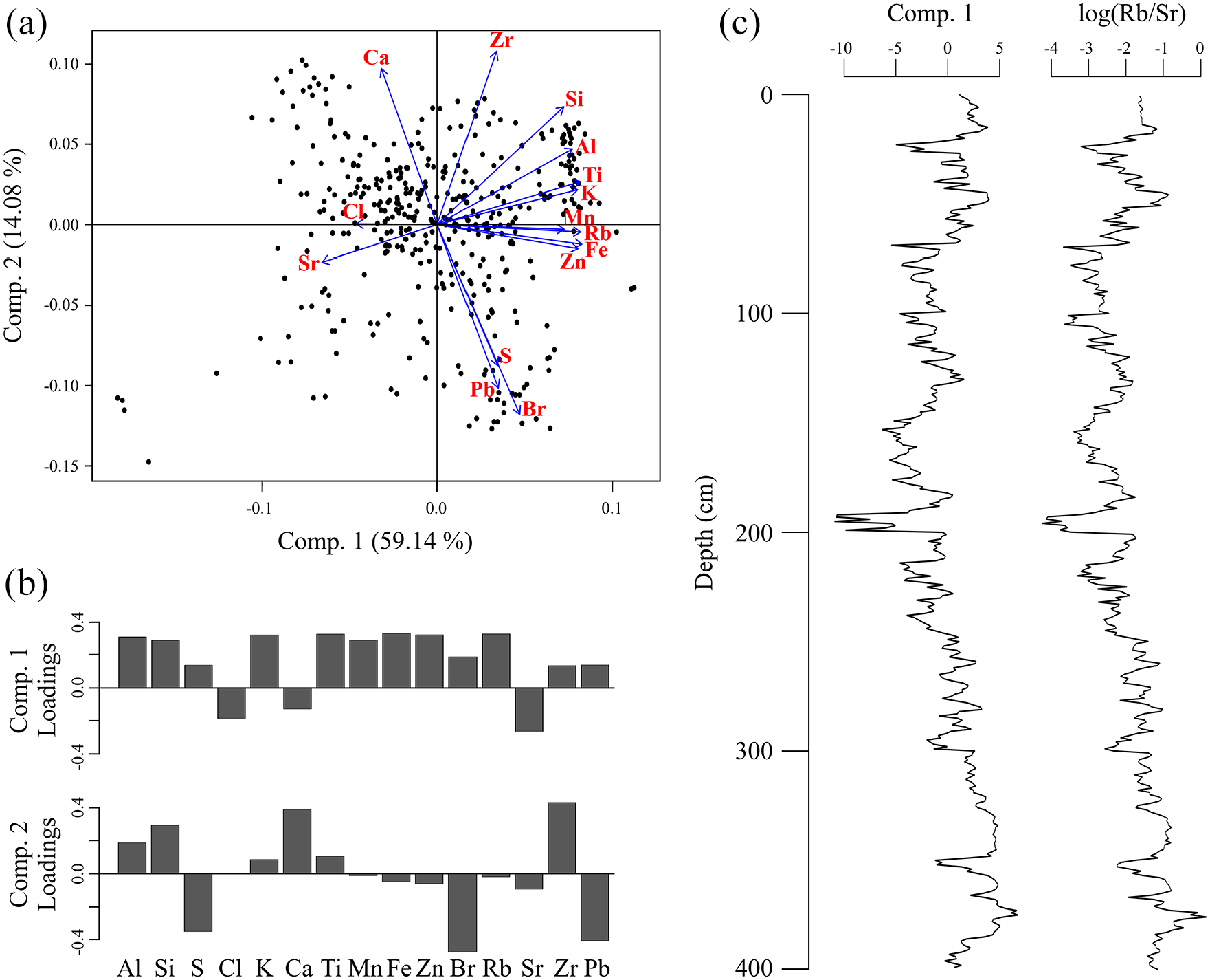
(a) PCA analysis of XRF data explaining 73.22% of the total variance, (b) variables loadings for the extracted components PC1 and PC2, and (c) component 1 scores (59.14%) and Rb/Sr distributions plotted against depth.
Foraminifera and ostracods
Foraminiferal and ostracods specimens that were identified in the studied samples are in a good state of preservation, indicating the relatively calm hydrodynamic status of the study area and also lack of carbonate dissolution due to oxic conditions in the shallow water of the lagoon. A total of 25 benthic foraminiferal species and eight ostracod species were identified (Figure 5). Minimum assemblages concentrations were found at 25 cm with ~500 foram/g, whereas all other samples assemblages ranged from ~750 to 3000 foram/g (Figure 5a).

(a) Relative assemblages (%) of the main foraminifera taxa identifies in the samples accompanied by foram/g and Shannon index distributions and (b) relative assemblages (%) of the main ostracods taxa identified in the samples.
The miliolids group, represented primarily by Quinqueloculina sp. and Spiroculina sp., presents increased relative abundances from 250 cm to top, with values ranging from 15% to 50% (Figure 5a). All studied samples showed high relative abundances of rotaliids (Ammonia tepida, Ammonia beccarii, Haynesina germanica, Haynesina depressula) (Figure 5a) with a distinct dominance of Ammonia tepida, especially from 250 to 400 cm (Figure 5a). Other taxa like Peneroplis pertusus, Elphidium crispum, Buccella frigida, Pararotalia spp., Rosalina spp., and Globorotalia spp., occurred only sporadically with relative abundances for all taxa <10% (Figure 5a). Higher values of the Shannon Wiener index are observed from 250 cm to top and range from 1.30 to 1.92 (Figure 5a). Lower values ranging from 0.80 to 1.68 are observed from 250 to 400 cm (Figure 5a).
Ostracod species are mostly represented by Cyprideis torosa and Loxoconcha elliptica, with the former presenting a monotonous distribution, excluding a decrease at 50 cm and a total absence at 375 cm (Figure 5b). In all other samples, assemblages of Cyprideis torosa presented relative abundances ranging from ~75% to 100% (Figure 5b). Sporadic presence of the freshwater taxa Cypria esculpta and Candona neglecta was observed from 50 to 150 cm and 125 to 175 cm, respectively (Figure 5b).
Palynology
A total of 84 pollen taxa (32 arboreal and 52 non-arboreal), 15 non-pollen palynomorphs, and 7 dinoflagellate cysts were identified and the dominant taxa for each palynomorph group are presented according to depth. Terrestrial pollen concentration (Figure 6) comprises a mean of 7000 grains g−1 and a maximum of 34,000 grains g−1 in the upper part of the sequence (KL-5) (Figure 6). Microscopic charcoal concentration (Figure 6) has a mean of 9000 particles g−1 and a maximum of 114,000 particles g−1 (KL-1). In contrast, dinoflagellate concentrations have a mean of 150 cysts g−1 and a maximum of 380 cysts g−1. Cluster analysis performed reveals five distinct zones that are comprised as follows.
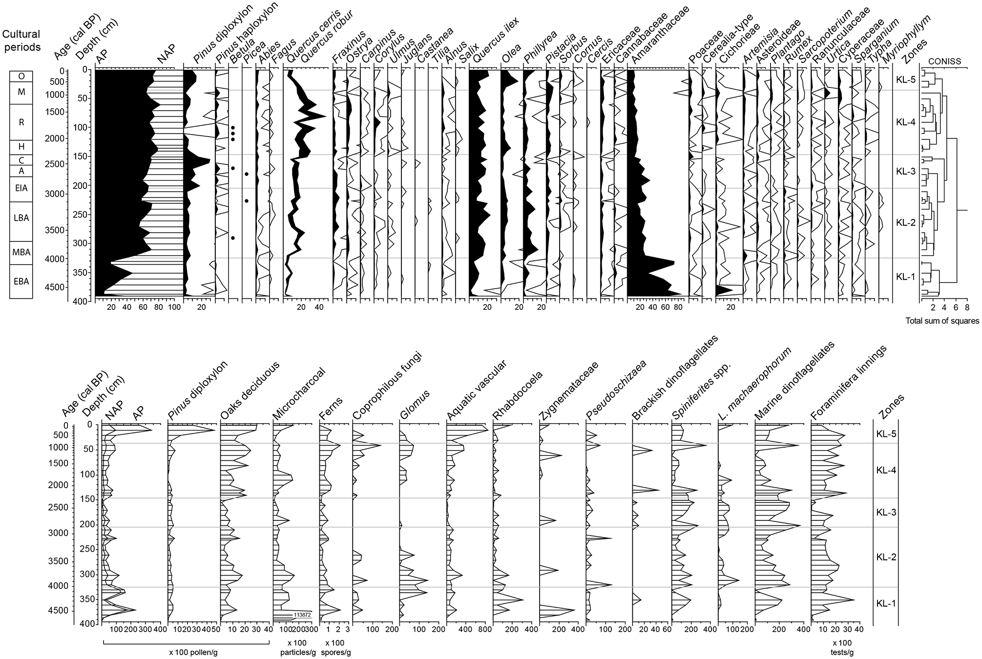
Pollen percentage diagram including selected arboreal and non-arboreal taxa (exaggeration ×10). Pollen assemblage zones (KL-1 to KL-5) based on cluster analysis for terrestrial pollen taxa (>2%) and cultural periods are shown. Concentration diagram of selected terrestrial and aquatic palynomorphs. The main Greek cultural boundaries, as specified by Weiberg et al. (2016) are presented next to the age column. Abbreviations are as follows, EBA: Early Helladic (5050–4050 a BP), MBA: Middle Helladic (4050–3650 a BP), LBA: Late Helladic/Mycenaean (3650–2850 a BP), EIA: Early Iron age (2850–2675 a BP), A: Archaic (2675–2429 a BP), C: Classical (2429–2273 a BP), H: Hellenistic (2273–1981 a BP), R: Roman (1981–1309 a BP), M: Medieval (1309–490 a BP), O: Ottoman (490–129 a BP), Md: Modern (129 a BP–Present).
Zone KL-1 (400–325 cm): High NAP (mean 75%, max 90%), high Amaranthaceae values (mean 60%, max 84%), Cichorieae (max 22%), high concentrations of charcoal (114,000 particles g−1), terrestrial pollen (23,400 grains g−1), ferns (max 214 spores g−1), Rhabdocoela (max 300 cocoons g−1), marine dinoflagellates (mean 68 and max 237 cysts g−1), and foraminifera (max 3500 test linings g−1) (Figure 6).
Zone KL-2 (325–205 cm): Higher AP values (mean 62%) than KL-1, increased deciduous Quercus (mean 15%, max 24%) evergreen Quercus (mean 15%, max 23%), Phillyrea (max 16%), Olea (mean 5.5%), reduced Amaranthaceae (mean 24%). Increased marine dinoflagellate cyst concentrations (mostly Spiniferites spp. and L. machaerophorum; mean 151 dinocysts g−1), Glomus present in concentrations up to 143 spores g−1.
Zone KL-3 (205–147 cm): AP (mean 67%), increase of Pinus (mean 17%, max 29%) Amaranthaceae (max 36%), deciduous Quercus (mean 17%, max 26%), reduced Phillyrea (max 7.5%), and Olea (mean 2.7%). Low terrestrial pollen concentration (mean 2500 grains g−1) with a pronounced minimum at 155 cm (676 grains g−1). Concentrations of marine dinoflagellate cysts (mean 240 and min 112 dinocysts g−1) foraminifera (mean 625 and min 22 test linings g−1), and microscopic charcoal (mean 4000 and min 750 particles g−1).
Zone KL-4 (147–36 cm): AP (mean 73%), increase of deciduous Quercus (mean 28.6%, max 47%), Ostrya (max 5.6%), Corylus (max 7.2%), Olea (mean 4.5%, max 11.3%), Pistacia (mean 3.7%), Cerealia-type (max 3%). Lower marine dinoflagellate cyst concentrations (mean 130 dinocysts g−1). S. cruciformis and L. machaerophorum with <10 μm processes maximum concentrations (44 dinocysts g−1). Increases in concentrations of aquatic vascular plant (mean 130 grains g−1), coprophilous fungi (max 140 spores g−1), and microscopic charcoal (mean 6050 particles g−1).
Zone KL-5 (36 cm–top): AP (mean72%), decrease of deciduous Quercus (mean 13.5%, min 9%) and increase of Pinus (max 11%), evergreen Quercus (max 21%), Olea (max 19%), Phillyrea (max 13%), Pistacia (max 8%). Increases in concentrations of terrestrial pollen (max 34,000 grains g−1), microscopic charcoal (max 15,500 particles g−1), aquatic vascular plants (max 850 grains g−1) (Figure 6).
Discussion
Evolution of Klisova lagoon
For the last 4700 years, the Klisova lagoon evolved primarily in response to Evinos river discharge and delta progradation, combined with climatic conditions and anthropogenic activity. The relatively uniform sediment textural characteristics in the core sequence, the absence of transported planktonic foraminifera, and small-scale grain size variations (Figure 2) reveal a relatively calm depositional environment, not prone to highly dynamic events. This is further supported by the good condition of faunal remnants and preservation of palynomorphs in the core. Rb/Sr ratio and PC1 present similar trajectories in the sequence (Figure 7) and reflect increased weathering in the catchment and clastic input in the lagoon (Heymann et al., 2013; Jin et al., 2006; Seguin et al., 2019; Unkel et al., 2010; Xu et al., 2010). During the weathering of the easily erodible Flysch formations (Maroukian and Karymbalis, 2004), due to enhanced precipitation in the area, Rb+ ions tend to substitute K+ ions due to differential absorption mechanisms (Heier and Billinus, 1970; Kylander et al., 2011). In contrast, Sr becomes more cumbersome in humid conditions (McLennan and Murray, 1999).
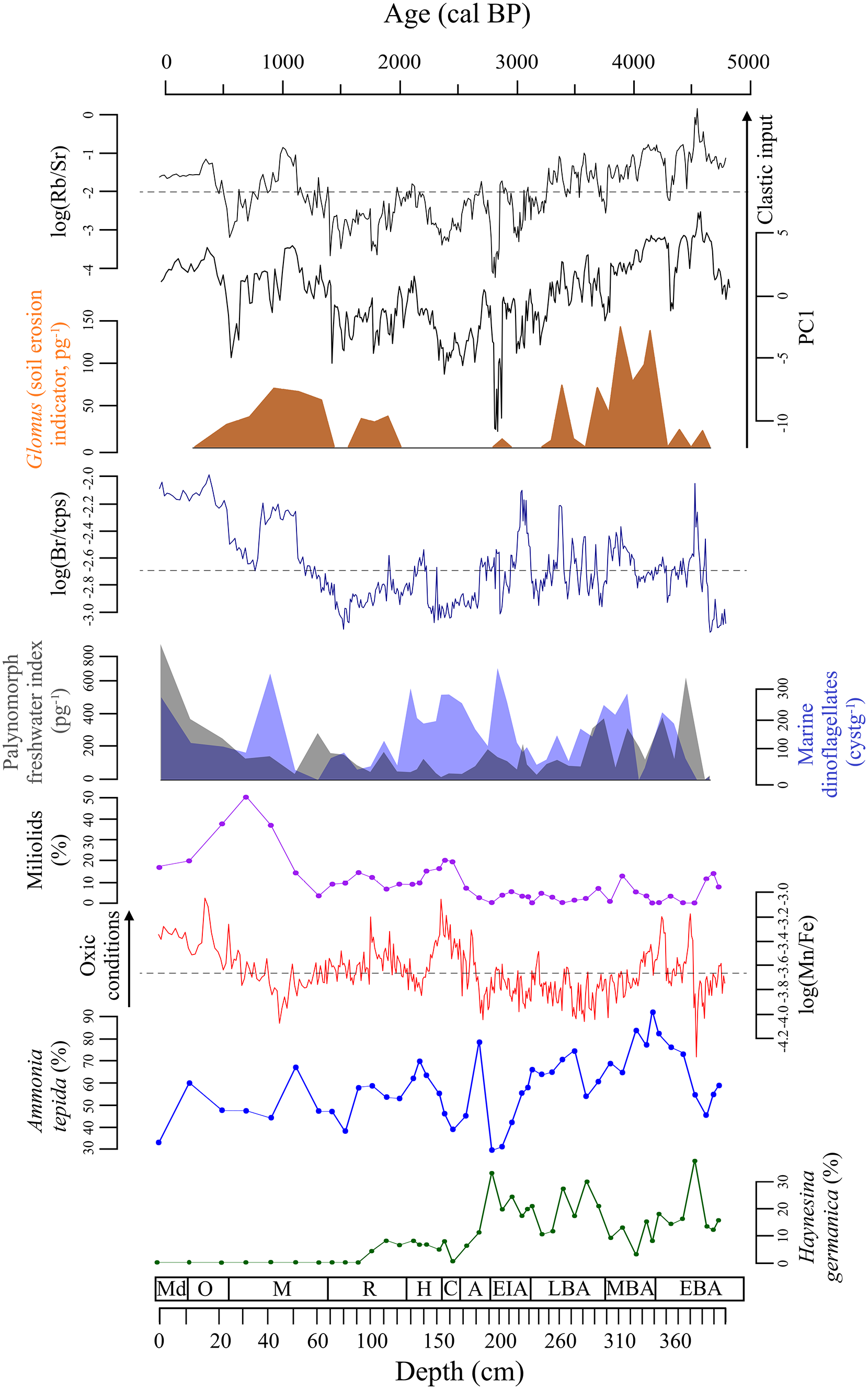
Synthetic diagram of selected micropaleontological, palynological, and geochemical proxies from KL-1A core, plotted against depth and age. The main Greek cultural boundaries, as specified by Weiberg et al. (2016) are presented next to the age column (for abbreviations see figure caption 6).
The salinity of the lagoon in modern times undergoes large seasonal variation depending on the evaporation and precipitation regime (Avramidis et al., 2010; Hotos and Avramidou, 1997), but overall brackish conditions prevail throughout the year. The dominance of brackish fauna in the sediment record of core KL-1A suggests similar conditions for the study interval. The shifts in the palynomorph-based freshwater index (Figure 7) point to changes in terrestrial runoff and are likely related to intervals of increased discharge of the two channels located in the northern part of the lagoon and Evinos river.
From 4700 to 2500 cal BP, the dominance of Ammonia tepida and Haynesina germanica (Figure 7) indicate a more closed lagoonal system (Melis and Violanti, 2006; Pavlopoulos et al., 2007, 2010; Ruiz et al., 2004; Triantaphyllou et al., 2003). Both species are tolerant in salinity fluctuations, so even in periods of increased freshwater influx, they were found in high relative abundances. The increased abundances of pollen from halophytic vegetation such as Amaranthaceae and the high concentrations of Rhabdocoela cocoons that occurs in the periphyton (Van Geel et al., 1980), between 4700 and 4000 cal BP point to a rather shallow water depth and to a proximal location of the coring site to the shore.
The most notable variation of faunal assemblages occurs at 2500 cal BP, with the gradual increase of the miliolid group (Figure 7), indicating a transition toward an open coastal environment rich in aquatic flora as found elsewhere by for example, Horne (1982), Cronin et al. (2001), Tsourou (2008), Triantaphyllou et al. (2010). This is also evidenced in the increasing abundances of aquatic vascular plants within zones KL-4 and KL-5 (Figure 6). Favorable conditions of aquatic flora and miliolids expansion during that period are further supported by the increase of Mn/Fe ratio (Figure 7), indicating oxic conditions (Koinig et al., 2003; Unkel et al., 2014) and high concentration of Mn ions which are essential in plant nutrition (Hurley and Keen, 1987).
Maxima of Rb/Sr and PC1 were recorded from 4700 to 3200 cal BP, 800 to 1100 cal BP, and 500 cal BP to present and are in good agreement with high Glomus concentrations showing increased soil erosion as well as peaks in the palynomorph freshwater index suggesting increased terrestrial run-off (Figure 7). Since those periods reflect enhanced weathering in the catchment, we can assume that humid climatic conditions prevailed in the area. A recent study based on geochemical and elemental analyses from neighboring lake Trichonida (Seguin et al., 2020) inferred similar trends. However, in such dynamic environments it becomes challenging to disentangle possible climatic forcing from local natural and anthropogenic drivers.
The dynamic environment of Klisova lagoon is characterized by fluctuations in marine and freshwater input during the studied interval. However, it appears that no stable barrier isolating the lagoon was formed. In the current state of the lagoon, the prodelta platform is still insufficient to damp down marine intrusions (Piper and Panagos, 1981). Freshwater fluxes inferred from the concentrations of Pseudoschizaea and Zygnemataceae suggest recurrent surges in terrestrial run-off throughout the entire sequence (Figure 6). The marine dinoflagellate cyst abundance peaks during the interval 3000 to 2000 and at 700 cal BP suggesting periodically amplified marine influence in the lagoon (Figure 6). Both intervals are also accompanied by a rise in the miliolid group and a relative decrease of Ammonia tepida (Figure 7). The mesohaline taxon Haynesina germanica (Koukousioura et al., 2012) is absent from 2500 cal BP to present (Figure 7), suggesting that the lagoon system entered into a state of higher salinity. Br ions, which are primarily transported from the marine environment (Hem, 1992), also increase after 1500 cal BP and reach maxima after 500 cal BP. After 500 cal BP, maxima in the palynomorph freshwater index (Figure 7) suggest an increase of terrestrial/fluvial run-off most likely related to climatic variability observed also in other regional records (e.g. Gogou et al., 2016; Lespez, 2003; Triantaphyllou et al., 2010).
Vegetation and land-use changes
Around 5000 BP, following the stabilization of the relative sea level rise in the Eastern Mediterranean (Grant et al., 2012), significant river delta progradation was accompanied by a distinct increase of human settlements in several coastal areas of Greece. In the study area, both the Acheloos and Evinos river deltas prograded with rates analogous to the Nile river delta (Poulos and Chronis, 1997). Examples of human activity intensification on delta plains can be observed in Eastern Greece at Lake Lerna (Jahns, 1993), Argos plain (Hansen and Nielsen, 2004), Tiryns (Rutter, 2001; Wiencke, 1989), Aliki salt pond (Emmanouilidis et al., 2020), and Vravron coastal marsh (Kouli, 2012; Triantaphyllou et al., 2010) and at the west at the ancient city of Pylos (Hope Simpson and Hagel, 2006), Kyllene harbor (Athanasoulis, 2013), and Zakynthos island (Avramidis et al., 2017b). In contrast, there is no significant human impact observed prior to the 3000 BP at the Croatian coast (Jahns and van Den Bogaard, 1998) and prior to the Roman times at the coastal Lake Butrint, located further north in Albania (Morellón et al., 2016, 2019). The pollen record of Klisova complements our knowledge on vegetation development and the impact of human activities in the surrounding area.
Between 4700 and 4000 cal BP (zone KL-1), corresponding to the Early Helladic period (Early Bronze Age; following Weiberg et al., 2016), the pollen record depicts a local vegetation signal that is characterized by the dominance of the halophytic vegetation (maximum in Amaranthaceae concentrations). The high concentration of freshwater indicators such as Zygnemataceae (Figure 6), herbaceous pollen (e.g. Asteroideae, Cichorieae, Rumex) and microscopic charcoal, suggest a dynamic depositional environment with increased terrestrial run-off (fluvial input) and is in good agreement with increased values of Rb/Sr ratio (Figure 8). Increased terrestrial run-off is inferred from Glomus, Pseudoschizaea, as well as terrestrial biomarker concentration peaks occurring between 5000 and 4000 cal BP in the Elefsis Bay (Attiki region; Kouli et al., 2021). During this period, a maximum concentration of arboreal pollen related to increased ecosystem productivity and maximum forest cover suggesting optimum growth conditions is reported from several lake sites across the southern Balkans, such as Lake Prespa (Panagiotopoulos et al., 2013) and Dojran (Masi et al., 2018). A period of ongoing warm and humid paleoclimatic conditions associated with the Mid-Holocene warm period (5400–4300 cal BP; Triantaphyllou et al., 2009, 2014) is also evident in the Aegean Sea.
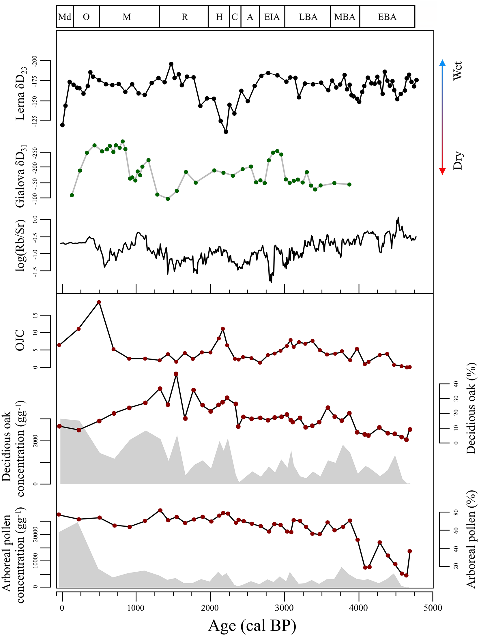
Comparison of pollen indices and Rb/Sr ratio of KL-1A core, with additional regional studies from Gialova lagoon (Katrantsiotis et al., 2018) and Lake Lerna (Katrantsiotis et al., 2019). The main Greek cultural boundaries, as specified by Weiberg et al. (2016) are presented next to the age column (for abbreviations see figure caption 6).
Within zone KL-2 covering the interval 4000–2900 cal BP (Middle Helladic/Middle Bronze Age to Early Iron Age), arboreal pollen dominates the assemblages recording vegetation at a regional scale (Figure 6). Pollen of Mediterranean sclerophyllous elements, such as Quercus ilex, Phillyrea, Olea, and Pistacia, indicate these trees were present in the lowlands surrounding the lagoon, while mesophilous mixed oak forest and conifers occupied the upland areas (Figure 6). The occurrence of synanthropic pollen taxa (such as Cerealia-type, Plantago, Sarcopoterium, Cichorieae), combined with high coprophilous fungal and microcharcoal concentrations, record the impact of human activities in the area during the Bronze Age (Figure 6). A gradual decrease in total AP concentration and reduced concentration of deciduous oaks, culminates within the end of the Late Helladic/Mycenaean Period indicating an opening of the landscape. Moreover, the peak abundances of Glomus, starting from the top of zone KL-1, indicate an increase in soil erosion, most likely associated with changes in land use, such as cultivation and animal husbandry. By 3100 cal BP, the concentrations of deciduous oaks and total AP reach a peak, suggesting a short phase of afforestation that implies a retreat in anthropogenic pressure in the area during the onset of the Early Iron Age.
Between 2900 and 2300 cal BP, (KL-3, Figure 6), a significant increase of Pinus pollen percentages is recorded at the expense of other tree species, such as Fraxinus, Ostrya, Corylus, and Ulmus. A similar expansion of pines has also been observed in several regional coastal records, like Voulkaria (Jahns, 2005), Lerna (Jahns, 1993), Vravron (Kouli, 2012), and Elefsis (Kyrikou et al., 2020). The short phase of woodland expansion at the end of the preceding zone KL-2 was reversed and a new phase of intensification of human activities during the Archaic and Classical Periods is inferred from decreasing concentration of AP and deciduous oaks. The maximum Pinus (Figure 6) and sand percentages at 155 cm (Figure 2) coincide with a minimum in terrestrial pollen (AP and NAP) and microscopic charcoal concentrations and may suggest a depositional artifact. Regional pollen records exhibit this increase of human activities corresponding to Bronze Age inhabitation for example, at Lake Voulkaria (Jahns, 2005), Kotychi lagoon (Lazarova et al., 2012), and regionally (Weiberg et al., 2016).
Favorable climatic conditions during the Mycenaean period in the Evinos and Acheloos delta basins may have been one of the main driving forces for the construction of the ancient cities of Kalydona and Plevron (Figure 1b), as well as Halkis, Pyleene, and Olenos (exact location of these cities is not verified yet) that flourished in the same period (Diamanti et al., 2014). Deforestation of the delta plains around 3280–2510 BP and increased denudation has been suggested for the Etoliko lagoon, to explain the increase of the sand fraction (Haenssler et al., 2013). At the same time, humid conditions are inferred from other regional records (Figure 8) such as Lake Lerna (Katrantsiotis et al., 2019) and the Asea valley (Unkel et al., 2014).
During the Early Iron Age (2850–2675 BP), Southern Greece is characterized by a decrease in human settlements (Weiberg et al., 2019), as a response to cultural and environmental change (e.g. Dickinson, 2006). The Klisova pollen record shows a short-lived decline in human activity in the area resulting in the afforestation of the landscape during the onset of the Early Iron Age. Transitions between dry and wet spells in the Archaic and Classical period are documented in the speleothem and lacustrine records of Peloponnese, while a wet spell is recorded at 2500–2400 cal BP (Boyd, 2015; Finné, 2014; Katrantsiotis et al., 2016; Norström et al., 2018; Figure 8). Around that time, the Oiniades port, which is now located 5 km inland, was constructed on the Acheloos river delta plain. The area of the seaport was gradually isolated as a result of the Acheloos river delta progradation and became inaccessible during winter due to the floods of the river (Vött et al., 2007b). A trend toward drier climatic conditions in the same period, with short wetter periods recorded from 2500 to 2200 cal BP has been inferred from the sedimentary record of Lake Trichonida, northern of Klisova (Seguin et al., 2020). The continuous human presence and induced disturbance in the area throughout the study interval do not allow for an unambiguous distinction between natural and anthropogenic drivers of landscape disturbance. In fact, across the whole Mediterranean region, inferring climate variability from pollen archives is hindered by the increasing human activity signal since around 4000 BP (Roberts et al., 2011; Sadori et al., 2011).
An expansion of mixed deciduous oak forests, as seen in maximum abundances of mesophilous tree pollen suggesting warm and humid conditions, is observed between 2300 and 800 cal BP (KL-4, Figure 6). The peak of Olea at the beginning of this interval is followed by peaks of Cerealia-type and Cichorieae, coprophilous fungi, and microcharcoal that indicate an intensification of human activities in the area since the onset of the Hellenistic period. Subsequently, between 2000 and 1700 cal BP, the decrease in deciduous oak concentration and the prominent peak in microcharcoal, record a period of intensive exploitation of natural resources during the Roman period. Despite the changes in land use featured in the fluctuations of synanthropic and soil erosion indicators, the oak forest cover appears unaffected until ~1000 cal BP. The Hellenistic period is characterized by increased anthropogenic activity in the area. Archeological evidence point to the construction of various cities that flourished in that period (Diamanti et al., 2014). In the Gialova record, there are no significant shifts in δD31 and δD23, during the Helenistic period (Western Greece; Katrantsiotis et al., 2018; Figure 8), while a gradual decrease of δD23 at Lake Lerna (Eastern Greece; Katrantsiotis et al., 2019; Figure 8) suggests a transition toward wetter conditions culminating during the Roman period. Since 1500 cal BP drier conditions are inferred from records from Western (e.g. Gialova, Agios Floros; Katrantsiotis et al., 2018; Norström et al., 2018) and Eastern (Lake Lerna; Katrantsiotis et al., 2019) Greece.
During the Medieval period, an increase in agricultural and animal herding indicators (Cerealia-type, Urtica, Cichorieae, coprophilous fungi) and increased soil erosion (Glomus) at 1100 cal BP is observed (Figure 6). This increase of anthropogenic impact indicators is concurrent with the peak of deciduous oak concentrations pointing to increased humidity. The peak of Rb/Sr ratio at 1100 cal BP, together with the decreasing δD31 values from Gialova lagoon (Katrantsiotis et al., 2018) indicate enhanced humidity and a common climatic trend in Western Greece (Figure 8). However, the inferred oak forest expansion could also be the result of an abandonment of higher elevation areas by the Byzantine population. A similar trend of increasing forest cover due to the abandonment of higher elevation areas during this period has been reported in other sites from northern Greece (e.g. Gogou et al., 2016; Kouli, 2020). This interval falls within the Medieval Climate Anomaly (MCA) period and is characterized by enhanced hydroclimatic variability in Greece (Finné, 2014; Gogou et al., 2016).
During the last 800 years (KL-5), a significant increase in Mediterranean vegetation elements (Q. ilex, Phillyrea, Pistacia), Pinus and a drop in deciduous Quercus percentages (Figure 6) was observed. A parallel maximum in evergreen vegetation percentages and concentrations (e.g. 7300 Q. ilex grains g−1) points to an expansion of the Mediterranean sclerophyllous vegetation in the lowlands. Within this interval, the maximum values of Olea resulting in a peak of OJC group point to extensive olive cultivation in the surrounding area during the Late Byzantine period (Figure 8). AP, Pinus diploxylon, and deciduous oaks reach their maximum concentration suggesting a period of increased forest cover in areas of higher elevation. The apparent discrepancy between low percentages and high concentrations of deciduous oak pollen occur within a period characterized by low sedimentation rates and can be most likely attributed to an amplification of the Mediterranean evergreen vegetation signal. Moreover, maxima in aquatic vascular plants, such as Sparganium type and Typha latifolia type (Figure 6) suggest decreasing water depth and/or distance of the coring site from the shore that might explain the aforementioned shift in the pollen signal.
The distinct peak in the palynomorph freshwater index suggests increased terrestrial run-off and fluvial discharge during a period that corresponds to the Little Ice Age (LIA). Intensified riverine run-off activity during the LIA has been reported from several sites, for example, Drama plain (Northern Greece; Lespez, 2003), the north Aegean marine record (Dimiza et al., 2020; Gogou et al., 2016), and at Vravron (Kouli, 2012; Triantaphyllou et al., 2010). The increase of Rb/Sr can potentially respond to the climatic forcing during the Little Ice Age (LIA) and is also detected in the Gialova lagoon δD31 and Lake Lerna δD23 records (Figure 8; Katrantsiotis et al., 2018, 2019). Similar patterns of increased clastic input into coastal systems can be observed since 1450 AD in the neighboring lagoon of Etoliko (Koutsodendris et al., 2017).
Conclusion
The multi-proxy record from the Klisova Lagoon infers notable environmental changes and anthropogenic activity for the last 4700 years. The lagoon evolution in the earliest stage is primarily constrained by the Evinos river delta progradation and the inflow of clastic material from the hinterland, controlled by prevailing climatic and environmental conditions. Foraminifera assemblages reflect two main phases, responding to the hydrological regime (primarily salinity) of the lagoon. From 4700 to 2500 cal BP, the dominance of brackish lagoonal taxa Ammonia tepida and Haynesina germanica, characterize the early phase of the lagoon development with enhanced freshwater inflow from the Evinos river and favorable conditions for these taxa. Peaks in palynomorph freshwater index and Glomus values during this interval point to increases in terrestrial run-off fluxes and erosion. Since 4000 cal BP, the pollen assemblages record Mediterranean evergreen and deciduous components capturing regional shifts in vegetation. Between 2500 to present, the lagoon shifted to a more open coastal system, as indicated by the increase of the miliolid group. This shift seems to be primarily attributed to changes in the Evinos river mouth and decreased freshwater inflow into the system. Periods of increased anthropogenic activity in the area were recorded as maxima of anthropogenic pollen indicators during the Mycenaean (~3200 cal BP), Hellenistic (~2200 cal BP), and late Byzantine (~800 cal BP) periods and correspond with an increase in settlement density in the area. Our study provides a more in-depth understanding of the evolution of Greece’s biggest lagoonal complex and how anthropogenic activities can be traced in a sedimentological archive.
Footnotes
Funding
The author(s) disclosed receipt of the following financial support for the research, authorship, and/or publication of this article: This research is co-financed by Greece and the European Union (European Social Fund – ESF) through the Operational Programme «Human Resources Development, Education and Lifelong Learning» in the context of the project “Strengthening Human Resources Research Potential via Doctorate Research” (MIS-5000432), implemented by the State Scholarships Foundation (ΙΚΥ).
